HIGHLIGHTS
- Third drill rig on site adding to the two already in operation at Eastmain
- Drilling capacity increased to c.1,500m/week - 38,000m drilled to date, on track to achieve the 2021 plan of 50,000m
- Drilling targeting DHEM conductors down-plunge of A and C Zones and extensions to E Zone
- Over 15,000 samples from 52 drillholes awaiting assays
- New style of mineralisation discovered at E Zone associated with a tonalite intrusion located structurally between the Kotak and Mine trend with visible gold observed
Toronto, Ontario--(Newsfile Corp. - October 20, 2021) - Benz Mining Corp. (TSXV: BZ) (ASX: BNZ) (the Company or Benz) is pleased to provide an update on its 2021 drilling campaign. The third drill rig, originally booked for September, is now on site at Eastmain and drilling electromagnetic targets down-plunge from the existing resource.
CEO, Xavier Braud, commented: "The third rig we needed to accelerate our drilling program is now in operation at Eastmain. Our current drilling capacity has increased to ~1,500m per week which will see us achieve our original target of 50,000m of drilling this year. We currently have over 15,000 samples awaiting assay results. Turnaround time at the laboratory has been extremely slow especially with the need for metallic screen fire assays. The discovery of a new mineralised system with visible gold at E Zone is also very exciting and we look forward to sharpening our understanding of this new fertile system. Eastmain is still surprising us which augurs very well for the future."

Figure 1: Eastmain Gold Project with 2021 drillholes pending assays, 2021 drilling with logged visible gold, DHEM conductors modelled to date and current drill rig location
To view an enhanced version of Figure 1, please visit:
https://orders.newsfilecorp.com/files/1818/100286_40359210d43bebaa_001full.jpg

Figure 2: Map view of the Eastmain Project with historical and current high grade drill results and 2021 drilling pending assays with EM conductors and simplified geology
To view an enhanced version of Figure 2, please visit:
https://orders.newsfilecorp.com/files/1818/100286_40359210d43bebaa_002full.jpg
Tonalite Zone discovery
At E Zone, drilling encountered a tonalite intrusion structurally located between the Kotak horizon and the Mine horizon.
This tonalite has a variable thickness over the area.
The tonalite shows numerous zones of alteration with silicification, sericitization and albitisation. Quartz veins are present with associated tourmaline and carbonate.
The tonalite also shows sulphide mineralisation as disseminations in the veins and on their margins. Sulphides include pyrite, pyrrhotite and chalcopyrite with occasional sphalerite and molybdenite. Garnet porphyroblasts are observed in the strongest alteration zones. Sulphide mineralisation coincides broadly with the conductors identified by downhole EM.
Quartz veins with carbonate within the tonalite contain visible gold.
Visible gold was also observed in the upper sheared contact between the tonalite and the overlying alternation of volcanics and ultramafics.

Figure 3: NE-SW Schematic geological cross section showing the newly discovered
mineralised tonalite intrusion at E Zone
To view an enhanced version of Figure 3, please visit:
https://orders.newsfilecorp.com/files/1818/100286_40359210d43bebaa_003full.jpg
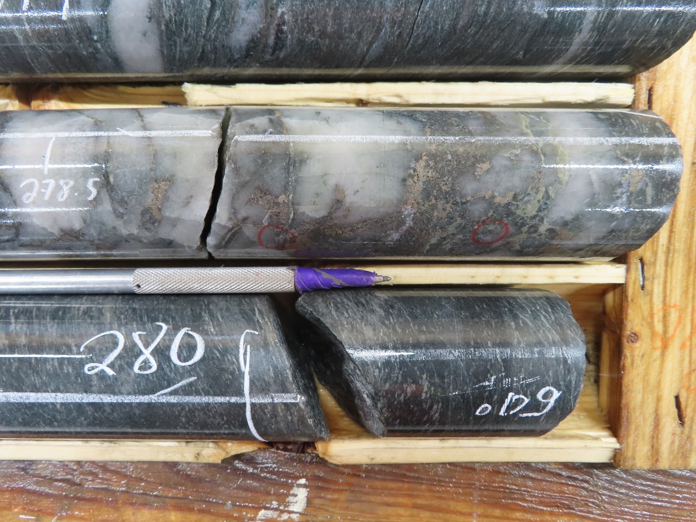
Figure 4: Mineralised tonalite contact with visible gold associated with quartz-pyrrhotite
veining (Hole EM21-167, 278.6m)
To view an enhanced version of Figure 4, please visit:
https://orders.newsfilecorp.com/files/1818/100286_40359210d43bebaa_004full.jpg
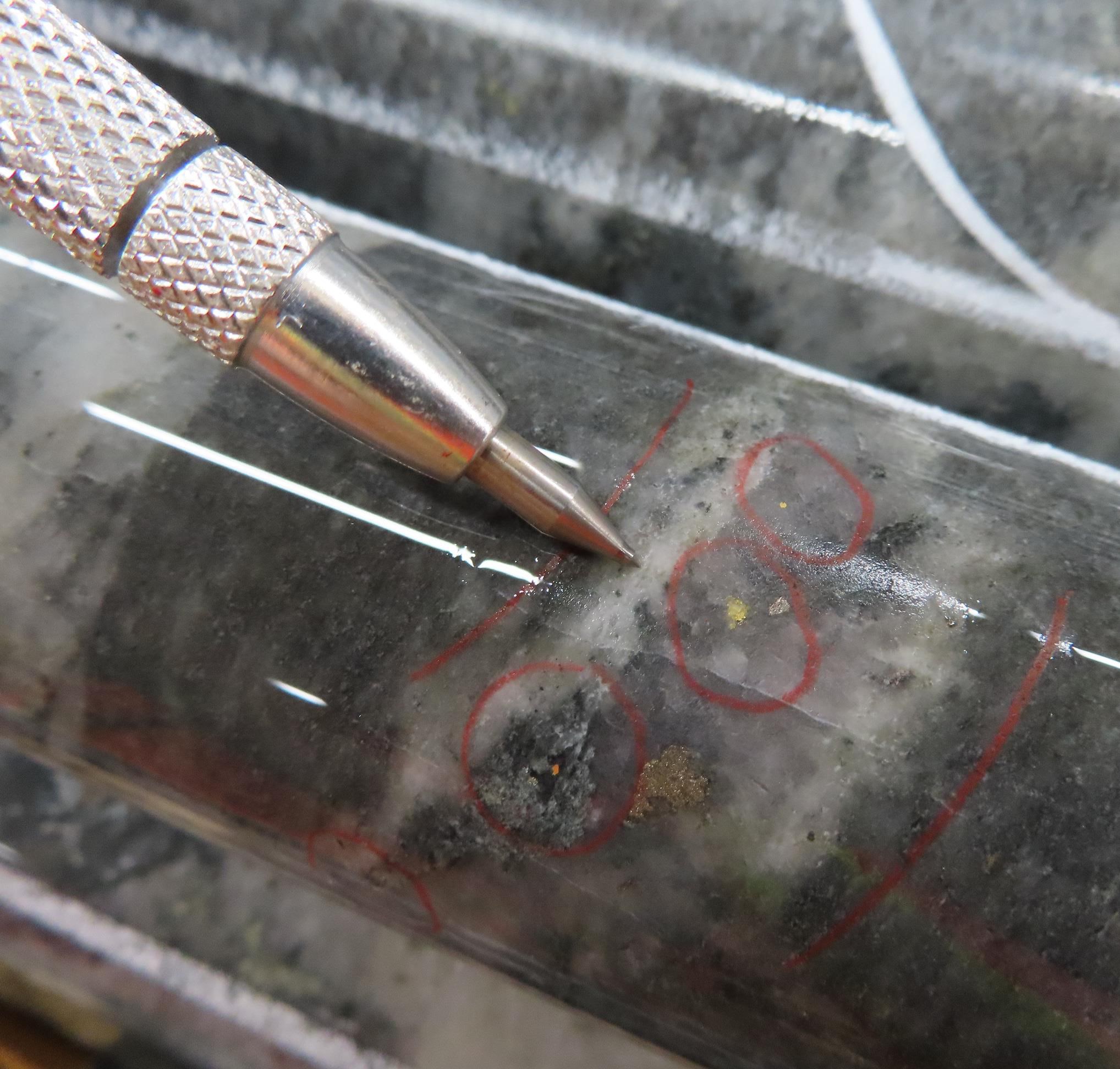
Figure 5:Mineralised vein is hosted in a moderately biotitized, silicified and albitized tonalite with tourmaline-quartz carbonate veins and local garnet porphyroblasts. (Hole EM21-207, 342.2m)
To view an enhanced version of Figure 5, please visit:
https://orders.newsfilecorp.com/files/1818/100286_40359210d43bebaa_005full.jpg
A and C Zones extensions at depth guided by DHEM
Drilling of DHEM conductors down-plunge from A and C Zones show that the mineralised system carries out at depth. The current drilling in those areas follows the same methodology applied by Benz in the last 12 months at Eastmain with 100m step-outs. Whilst this spacing is too wide to establish a resource estimate from the current drilling, it gives the Company a much better understanding of the potential footprint of the deposit before planning infill drilling.

Figure 6: C Zone depth extension (EM21-205, 601.0m)
To view an enhanced version of Figure 6, please visit:
https://orders.newsfilecorp.com/files/1818/100286_40359210d43bebaa_006full.jpg

Figure 7: A Zone depth extension, Mine horizon with quartz, pyrrhotite, pyrite and chalcopyrite (EM21-204B, 564.7m)
To view an enhanced version of Figure 7, please visit:
https://orders.newsfilecorp.com/files/1818/100286_40359210d43bebaa_007full.jpg
Eastmain Gold Project
The Eastmain Gold Project, situated on the Upper Eastmain Greenstone Belt in Quebec, Canada, currently hosts a NI 43-101 and JORC (2012) compliant resource of 376,000oz at 7.9gpt gold (Indicated: 236,500oz at 8.2gtp gold, Inferred: 139,300oz at 7.5gtp gold). The existing gold mineralisation is associated with 15-20% semi-massive to massive pyrrhotite, pyrite and chalcopyrite in highly deformed and altered rocks making it amenable to detection using electromagnetic techniques. Multiple gold occurrences have been identified by previous explorers over a 10km long zone along strike from the Eastmain Mine with very limited but highly encouraging testing outside the existing resource area. Benz has subsequently identified over 150 DHEM conductors over a strike length of 6km which is open in all directions.
This press release was prepared under supervision and approved by Dr. Danielle Giovenazzo, P.Geo, acting as Benz's qualified person under National Instrument 43-101.
About Benz Mining Corp.
Benz Mining Corp. brings together an experienced team of geoscientists and finance professionals with a focused strategy to acquire and develop mineral projects with an emphasis on safe, low risk jurisdictions favourable to mining development. Benz is earning a 100% interest in the former producing high grade Eastmain gold mine, Ruby Hill West and Ruby Hill East projects in Quebec.
The Eastmain Gold Project is situated within the Upper Eastmain Greenstone Belt in Quebec, Canada and currently hosts a NI 43-101 and JORC (2012) compliant resource of 376,000oz at 7.9gpt gold. The existing gold mineralization is associated with 15-20% semi-massive to massive pyrrhotite, pyrite and chalcopyrite making it amenable to detection by electromagnetics. Several gold mineralization occurrences have been identified by previous explorers over a 10km long zone along strike from the Eastmain Mine with very limited testing outside the existing resource area.

Figure 8: Benz tenure over Upper Eastmain Greenstone Belt simplified geology.
To view an enhanced version of Figure 8, please visit:
https://orders.newsfilecorp.com/files/1818/100286_40359210d43bebaa_008full.jpg
On behalf of the Board of Directors of Benz Mining Corp.
Xavier Braud, CEO
For more information please contact:
Paul Fowler
Head of Corporate Development (Canada)
Benz Mining Corp.
Telephone: +1 416 356 8165
Email: info@benzmining.com
Xavier Braud
CEO, Head of Corporate Development (Aus)
Benz Mining Corp.
Telephone +61 423 237 659
Email: info@benzmining.com
Forward-Looking Information: Certain statements contained in this news release may constitute "forward-looking information" as such term is used in applicable Canadian securities laws. Forward-looking information is based on plans, expectations and estimates of management at the date the information is provided and is subject to certain factors and assumptions, including, that the Company's financial condition and development plans do not change as a result of unforeseen events and that the Company obtains regulatory approval. Forward-looking information is subject to a variety of risks and uncertainties and other factors that could cause plans, estimates and actual results to vary materially from those projected in such forward-looking information. Factors that could cause the forward-looking information in this news release to change or to be inaccurate include, but are not limited to, the risk that any of the assumptions referred to prove not to be valid or reliable, that occurrences such as those referred to above are realized and result in delays, or cessation in planned work, that the Company's financial condition and development plans change, and delays in regulatory approval, as well as the other risks and uncertainties applicable to the Company as set forth in the Company's continuous disclosure filings filed under the Company's profile at www.sedar.com. The Company undertakes no obligation to update these forward-looking statements, other than as required by applicable law.
NEITHER THE TSX VENTURE EXCHANGE NOR ITS REGULATION SERVICES PROVIDER (AS THAT TERM IS DEFINED IN THE POLICIES OF THE TSX VENTURE EXCHANGE) ACCEPTS RESPONSIBILITY FOR THE ACCURACY OR ADEQUACY OF THIS RELEASE.
Competent Person's Statements: The information in this report that relates to Exploration Results is based on and fairly represents information and supporting information compiled by Mr Xavier Braud, who is a member of the Australian Institute of Geoscientists (AIG membership ID:6963). Mr Braud is a consultant to the Company and has sufficient experience in the style of mineralization and type of deposits under consideration and qualifies as a Competent Person as defined in the 2012 edition of the "Australasian Code for Reporting of Exploration Results, Mineral Resources and Ore Reserves". Mr Braud holds securities in Benz Mining Corp and consents to the inclusion of all technical statements based on his information in the form and context in which they appear.
The information in this announcement that relates to the Inferred Mineral Resource was first reported under the JORC Code by the Company in its prospectus released to the ASX on 21 December 2020. The Company confirms that it is not aware of any new information or data that materially affects the information included in the original market announcement and confirms that all material assumptions and technical parameters underpinning the estimate continue to apply and have not materially changed. The Company confirms that the form and context in which the Competent Person's findings are presented have not been materially modified from the original market announcement.
Appendix 1: Collar Table 2021 Drilling
| DDH ID | X_NAD83_Z18N | Y_NAD83_Z18N | Elevation | Azimuth (planned) | Azimuth (measured) | Dip planned | Dip (measured) | Planned Depth | Total Drilled length |
| EM21-143 | 698713 | 5798618 | 485.0 | 215 | 215.35 | -56.9 | 56.92 | 550 | 567 |
| EM21-144 | 698568 | 5799058 | 485 | 215 | 215.1 | -75 | 75 | 450 | 477 |
| EM21-145 | 698315 | 5799210 | 487 | 215 | 215.3 | -60 | 60 | 350 | 333 |
| EM21-146 | 698280 | 5799265 | 495 | 215 | 215 | -60 | 60 | 350 | 297 |
| EM21-147 | 698184 | 5799041 | 490 | 220 | 220 | -55 | 55 | 200 | 225 |
| EM21-148 | 698192 | 5799167 | 491 | 220 | 220 | -60 | 55 | 265 | 265 |
| EM21-149 | 698014 | 5799532 | 487 | 217 | 217 | -55 | 54.9 | 220 | 225 |
| EM21-150 | 698182 | 5799743 | 510 | 217 | 217.1 | -55 | 54.9 | 165 | 201 |
| EM21-151 | 698569 | 5798713 | 483 | 216 | 216.19 | -60 | 60.4 | 620 | 657 |
| EM21-152 | 699236 | 5798936 | 508 | 225 | 225 | -75 | 74.9 | 600 | 636 |
| EM21-153 | 699248 | 5798810 | 480 | 225 | 225.3 | -80 | 80.5 | 620 | 619.3 |
| EM21-154 | 699247 | 5799006 | 484 | 225 | 225.16 | -75 | 75 | 610 | 675 |
| EM21-155 | 698518 | 5798790 | 486 | 220 | 219.88 | -60 | 60.4 | 575 | 585 |
| EM21-156 | 698582 | 5799177 | 485 | 215 | 215.04 | -75 | 75.3 | 450 | 507 |
| EM21-157 | 698434 | 5799154 | 485 | 240 | 239.9 | -60 | 58 | 450 | 471 |
| EM21-158 | 698405 | 5799250 | 483 | 245 | 249 | -60 | 59 | 600 | 648 |
| EM21-159 | 698520 | 5799290 | 484 | 245 | 244.5 | -65 | -64.9 | 450 | 450 |
| EM21-160 | 700655 | 5797357 | 503 | 215 | 214.66 | -70 | -70.4 | 450 | 477 |
| EM21-161 | 701002 | 5797424 | 499 | 215 | 214.9 | -60 | -60.2 | 300 | 351 |
| EM21-162 | 700174 | 5798070 | 488 | 210 | 210.4 | -65 | -65.3 | 550 | 651 |
| EM21-163 | 701190 | 5797310 | 509 | 215 | 215.3 | -60 | -60 | 300 | 201 |
| EM21-164 | 701030 | 5797282 | 524 | 210 | 210.4 | -60 | -60.2 | 200 | 273 |
| EM21-165 | 700394 | 5798111 | 487 | 210 | -74 | -73.9 | 800 | 783 | |
| EM21-166 | 701160 | 5797442 | 494 | 215 | 214.9 | -60 | -60.6 | 380 | 411 |
| EM21-167 | 701401 | 5797480 | 503 | 180 | 180.1 | -70 | -70.2 | 360 | 468 |
| EM21-168 | 700280 | 5798134 | 485 | 210 | 210.3 | -75 | -75 | 680 | 687 |
| EM21-169 | 701246 | 5797779 | 490 | 210 | 209.6 | -75 | -74.6 | 450 | 621 |
| EM21-170 | 700276 | 5797965 | 490 | 210 | 210.3 | -70 | -70.4 | 600 | 636 |
| EM21-171 | 700171 | 5797963 | 489 | 210 | 210 | -70 | -70.3 | 525 | 567 |
| EM21-172 | 700605 | 5797443 | 495 | 210 | 209.9 | -60 | -60 | 450 | 453 |
| EM21-173 | 700297 | 5797805 | 492 | 210 | 204.3 | -70 | -71 | 460 | 463 |
| EM21-174 | 701371 | 5798073 | 484 | 210 | 209.65 | -65 | -65.3 | 800 | 781.45 |
| EM21-175 | 700226 | 5797876 | 487 | 206 | 207.71 | -70 | -70 | 550 | 573 |
| EM21-176 | 701210 | 5798045 | 483 | 213 | 212.8 | -67 | -67 | 610 | 624 |
| EM21-177 | 700114 | 5797875 | 486 | 210 | 209.9 | -70 | -70.1 | 465 | 471 |
| EM21-178 | 700263 | 5798666 | 481 | 215 | 215.3 | -65 | -65 | 600 | 603 |
| EM21-179 | 700062 | 5797789 | 485 | 210 | 209.9 | -70 | -70.1 | 400 | 444 |
| EM21-180 | 700357 | 5798529 | 482 | 210 | 210.1 | -70 | -70.5 | 650 | 648 |
| EM21-181 | 700181 | 5797790 | 487 | 210 | 209.9 | -65 | -65.2 | 490 | 486 |
| EM21-182 | 700341 | 5798224 | 484 | 210 | 209.9 | -75 | -75.2 | 700 | 780 |
| EM21-183 | 700080 | 5798025 | 485 | 210 | 209.8 | 68 | -67 | 600 | 669 |
| EM21-184 | 700368 | 5797902 | 491 | 210 | 210.2 | -70 | -70.1 | 600 | 573 |
| EM21-185 | 700305 | 5798405 | 486 | 210 | 209.47 | -70 | -70.02 | 800 | 804 |
| EM21-186 | 700262 | 5797716 | 494 | 210 | 209.5 | -70 | -70.1 | 420 | 474 |
| EM21-187 | 700428 | 5798232 | 487 | 210 | 205.65 | -75 | -75.2 | 780 | 831 |
| EM21-188 | 700188 | 5797587 | 492 | 210 | -70 | -70.1 | 380 | 342 | |
| EM21-189 | 700039 | 5797566 | 495 | 210 | 209.45 | -70 | -69.94 | 350 | 309 |
| EM21-190 | 700675 | 5797450 | 497 | 210 | 210.7 | -65 | -65.88 | 450 | 474 |
| EM21-191 | 700474 | 5798085 | 492 | 210 | 208.3 | -70 | -69.83 | 680 | 696 |
| EM21-192 | 701121 | 5797475 | 504 | 215 | 215 | -60 | -59.9 | 380 | 429 |
| EM21-193 | 701204 | 5797420 | 494 | 215 | 215.2 | -60 | -59.9 | 430 | 420 |
| EM21-194 | 700230 | 5798513 | 490 | 210 | 209.7 | -70 | -70.1 | 800 | 837 |
| EM21-195 | 701352 | 5797496 | 500 | 185 | 184.8 | -70 | -70.1 | 460 | 513 |
| EM21-196 | 701352 | 5797496 | 500 | 215 | 215.4 | -60 | -59.7 | 750 | 750 |
| EM21-197 | 700253 | 5798660 | 479 | 200 | 196.7 | -82 | -83 | 550 | 798 |
| EM21-198 | 701457 | 5797479 | 505 | 185 | 185.4 | -70 | -70.4 | 550 | 591 |
| EM21-199 | 699463 | 5798380 | 480 | 215 | 214.7 | -70 | -69.9 | 650 | 720 |
| EM21-200 | 701470 | 5797599 | 513 | 185 | 184.83 | -70 | -69.9 | 550 | 654 |
| EM21-201 | 699599 | 5798581 | 484 | 210 | 209.6 | -70 | -70 | 750 | 816 |
| EM21-202 | 701389 | 5797381 | 502 | 185 | 184.9 | -70 | -70 | 450 | 528 |
| EM21-203 | 699776 | 5798523 | 483 | 215 | 215.1 | -70 | -70.1 | 670 | 627 |
| EM21-204-B | 699141 | 5799038 | 487 | 215 | 215.4 | -70 | -70.1 | 600 | 711 |
| EM21-205 | 699783 | 5798534 | 482 | 215 | 214.9 | -80 | -79.9 | 700 | 693 |
| EM21-206 | 701545 | 5797486 | 513 | 185 | 185.1 | -70 | -69.9 | 550 | 600 |
| EM21-207 | 701411 | 5797582 | 505 | 185 | N/A | -70 | N/A | 480 | 591 |
| EM21-208 | 699050 | 5799080 | 493 | 215 | 215.89 | -70 | -70.28 | 650 | 588 |
| EM21-209 | 699735 | 5798655 | 482 | 215 | 215.7 | -75 | -75.02 | 650 | 741 |
| EM21-210 | 701222 | 5797541 | 503 | 215 | 214.33 | -65 | -65.51 | 500 | 510 |
| EM21-211 | 699095 | 5798740 | 485 | 220 | 220.91 | -70 | -69.92 | 500 | 471 |
| EM21-212 | 699647 | 5798671 | 477 | 215 | N/A | -70 | N/A | 700 | In progress |
| EM21-213 | 700971 | 5797181 | 531 | 215 | 215.05 | -60 | -60.1 | 300 | In progress |
| EM21-214 | 699169 | 5798821 | 481 | 220 | 219.8 | -70 | -69.8 | 550 | In progress |
Appendix 2: JORC Tables
Section 1 Sampling Techniques and Data
(Criteria in this section apply to all succeeding sections.)
| Criteria | JORC Code explanation | Commentary |
| Sampling techniques |
|
|
| Drilling techniques |
|
|
| Drill sample recovery |
|
|
| Logging |
|
|
| Sub-sampling techniques and sample preparation |
|
|
| Quality of assay data and laboratory tests |
|
|
| Verification of sampling and assaying |
|
|
| Location of data points |
|
|
| Data spacing and distribution |
|
|
| Orientation of data in relation to geological structure |
|
|
| Sample security |
|
|
| Audits or reviews |
|
|
Section 2 Reporting of Exploration Results
(Criteria listed in the preceding section also apply to this section.)
| Criteria | JORC Code explanation | Commentary |
| Mineral tenement and land tenure status |
|
|
| Exploration done by other parties |
|
|
| Geology |
|
|
| Drill hole Information |
|
|
| Data aggregation methods |
|
|
| Relationship between mineralisation widths and intercept lengths |
|
|
| Diagrams |
|
|
| Balanced reporting |
|
|
| Other substantive exploration data |
|
|
| Further work |
|
|
![]()
To view the source version of this press release, please visit https://www.newsfilecorp.com/release/100286
Source: Benz Mining Corp.