HIGHLIGHTS:
Third lens discovery - Step out drilling has uncovered a new third lens approximately 70m south east of the second lens:
11m at 5.5g/t gold from 196m (25GLR039)
20m at 2.6g/t gold from 507m (25GLR035)
Including 5m at 5.4g/t gold
Exploration efforts will now prioritise this new lens horizon, with systematic drilling planned to define its scale and continuity which currently exceeds over 300m of vertical extent.
Deep extension below Lens 2 - Drilling beneath the second lens has confirmed significant vertical and grade continuity, extending the known mineralisation over 100m down plunge:
10m at 6.1g/t gold from 450m (25GLR033)
Including 3m at 16.8g/t gold
Within a broader zone of 108m at 0.9g/t gold from 408m
5m at 13.5g/t gold from 361m (25GLR037)
Within a broader zone of 123m at 1g/t gold from 355m
6m at 7.4g/t gold from 300m (25GLR039)
The discovery confirms Benz's breakthrough structural model, showing that earlier drilling at Glenburgh missed key mineralised zones due to incorrect orientation. Two RC rigs continue drilling on site, fully funded by recently completed A$13.5m capital raise.
Vancouver, British Columbia--(Newsfile Corp. - July 30, 2025) - Benz Mining Corp (ASX: BNZ) (TSXV: BZ) ("Benz" or the "Company") is pleased to report further strong results from ongoing drilling at the Zone 126 prospect within the Glenburgh Gold Project in Western Australia. The latest results have successfully confirmed two major developments:
- the discovery of a new third lens or mineralisation; and
- a significant 100m down-dip extension of known mineralisation beneath the second lens.
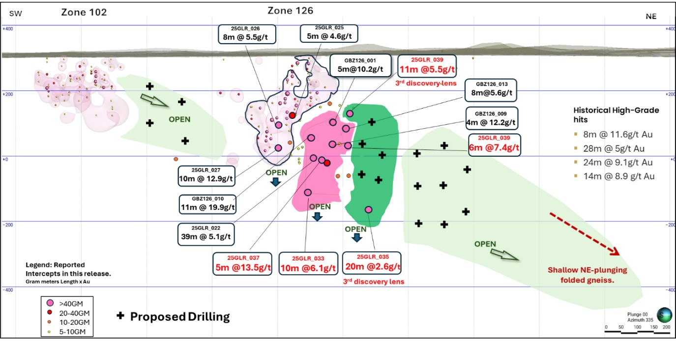
Figure 1 Long section view looking north of Zone 126 trend. Proposed drilling demarcated by black crosses. Current release results in red text. Previous results released on 6 November 2024 and 3 April 2025.
To view an enhanced version of this graphic, please visit:
https://images.newsfilecorp.com/files/1818/260789_13f04f74e46e4ae7_001full.jpg
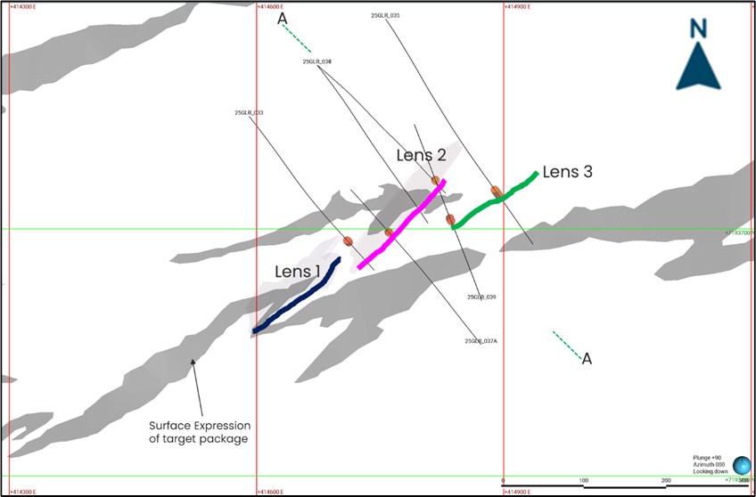
Figure 2 Plan View of new Lens 3 discovery in green, with Lens 2 in pink, and Lens 1 in Dark blue . Grey polygon is surface gold expression of target package. Collars in this release plotted.
To view an enhanced version of this graphic, please visit:
https://images.newsfilecorp.com/files/1818/260789_13f04f74e46e4ae7_002full.jpg
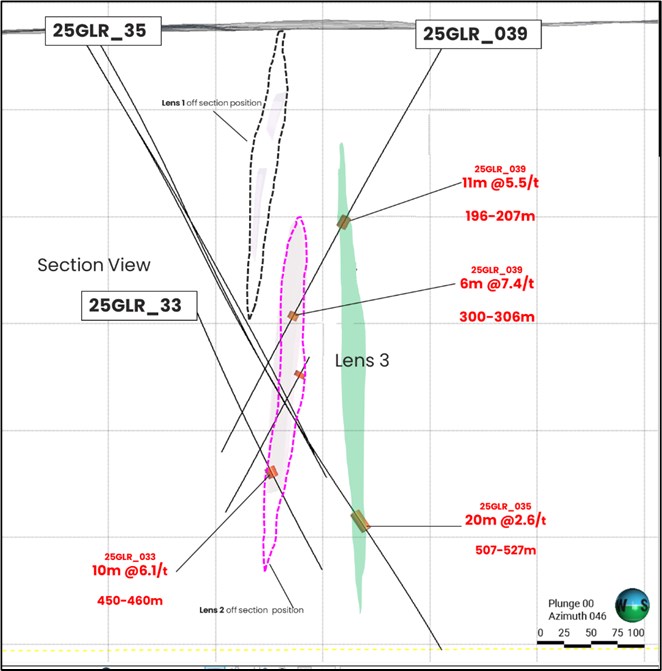
Figure 3 Section View A-A looking NE.
To view an enhanced version of this graphic, please visit:
https://images.newsfilecorp.com/files/1818/260789_13f04f74e46e4ae7_003full.jpg
High Grade Third Lens Discovery
Step-out drilling approximately 70 metres down plunge from the existing second lens has intersected a previously unrecognised third lens of high-grade gold mineralisation. The third lens has been intersected with 2 drill holes, with hole 25GLR_039 intersecting the lens at 196m with drill hole 25GLR_035 intersecting the same lens at 507m representing a potential down dip target zone of over 300m in length.
This emerging lens further validates Benz's structural targeting model which suggested that gold mineralisation at Zone 126 plunges to the north east as opposed to previous exploration that targetted a south westerly plunge.
Hole 25GLR_039 also intersected the second lens, returning additional high-grade mineralisation (25GLR_039: 6m at 7.4/t gold) that reinforces the continuity of the system between the second and newly identified third lenses.
Exploration efforts will now prioritise this new lens horizon, with systematic drilling planned to test its full scale and continuity. The discovery opens up significant potential for high grade near-resource growth and underlines the broader structural complexity and fertility of the system with the system continuing to be open along the strike of the north easterly plunge as well to surface and depth.
Deep Extension Below Lens 2
In addition to the new lens discovery, drilling below the second lens has confirmed substantial vertical continuity of mineralisation, extending the system by more than 100 metres down-dip. This demonstrates that the gold system at Zone 126 remains open at depth and continues to exhibit strong grade characteristics at increasing depths.
These results confirm the presence of a large, vertically extensive gold system at Zone 126. Importantly, both Lens 1 and Lens 2 remain open at depth, with further drilling planned to test the full extent of this mineralisation along plunge and down dip.
The ongoing success of the drilling program at Zone 126 continues to highlight the exceptional upside potential at Glenburgh, with high-grade discoveries emerging alongside the Project's growing bulk-tonnage footprint.
Benz CEO, Mark Lynch-Staunton, commented:
"Glenburgh just keeps delivering. This latest discovery of a third high-grade lens at Zone 126 not only extends the system down plunge, but also further validates our structural model - a model that continues to unlock new growth across the Project.
"To see consistent high grades and widths over 50 gram metres continuously being intersected in now 2 new discoveries gives us great confidence that we are beginning to unlock a high grade underground gold project.
"Developing these exciting high grade discoveries alongside the large-scale bulk tonnage system at Icon-Apollo is what makes Glenburgh truly special.
"We believe Glenburgh has the hallmarks of a tier 1, multi-million-ounce opportunity, and we're only just getting started."
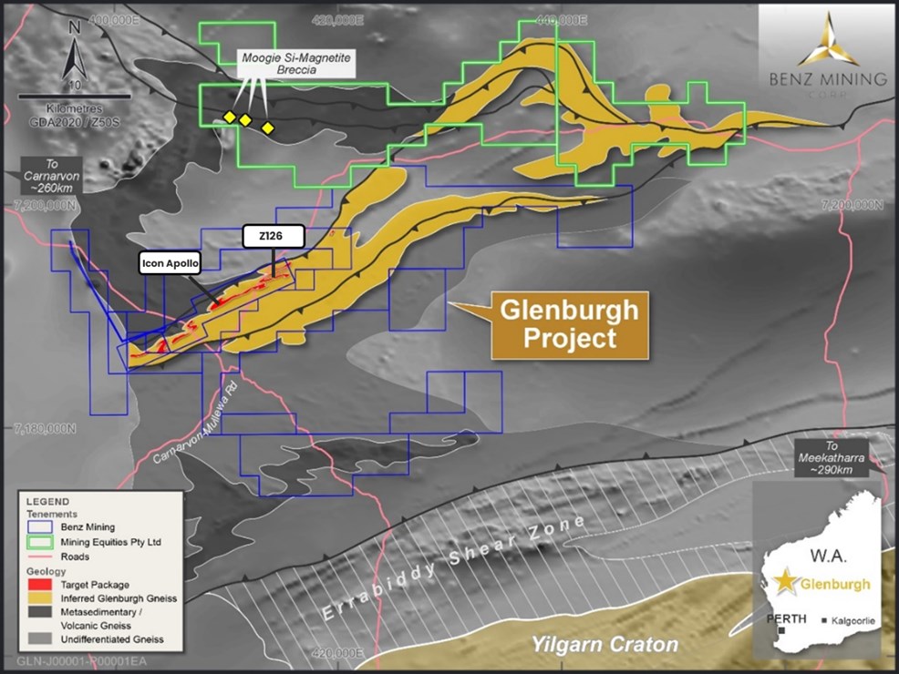
Figure 4 Glenburgh Project Geology overview.
To view an enhanced version of this graphic, please visit:
https://images.newsfilecorp.com/files/1818/260789_13f04f74e46e4ae7_004full.jpg
This announcement has been approved for release by the Board of Benz Mining Corp.
For more information please contact:
Mark Lynch-Staunton
Chief Executive Officer
Benz Mining Corp.
E: mstaunton@benzmining.com
T: +61 8 6143 6702
About Benz Mining Corp.
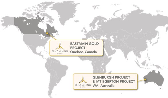
Benz Mining Corp. (TSXV: BZ) (ASX: BNZ) is a pure-play gold exploration company dual-listed on the TSX Venture Exchange and Australian Securities Exchange. The Company owns the Eastmain Gold Project in Quebec, and the recently acquired Glenburgh and Mt Egerton Gold Projects in Western Australia.
Benz's key point of difference lies in its team's deep geological expertise and the use of advanced geological techniques, particularly in high-metamorphic terrane exploration. The Company aims to rapidly grow its global resource base and solidify its position as a leading gold explorer across two of the world's most prolific gold regions.
The Glenburgh Gold Project features a Historical (for the purposes of NI 43-101) Mineral Resource Estimate of 16.3Mt at 1.0 g/t Au (510,100 ounces of contained gold)1. A technical report prepared under NI 43-101- Standards of Disclosure for Mineral Projects (NI 43-101) titled "NI 43-101 Technical Report on the Glenburgh - Egerton Gold Project, Western Australia" with an effective date of 16 December 2024 has been filed with the TSX Venture Exchange and is available under the Company's profile at www.sedarplus.ca.
The Eastmain Gold Project in Quebec hosts a Mineral Resource Estimate dated effective May 24, 2023 and prepared in accordance with NI 43-101 and JORC (2012) of 1,005,000 ounces at 6.1g/t Au2, also available under the Company's profile at www.sedarplus.ca, showcasing Benz's focus on high-grade, high-margin assets in premier mining jurisdictions.
To view an enhanced version of this graphic, please visit:
https://images.newsfilecorp.com/files/1818/260789_13f04f74e46e4ae7_005full.jpg
For more information, please visit: https://benzmining.com/.
Qualified Person's Statement (NI 43-101)
The disclosure of scientific or technical information in this news release is based on, and fairly represents, information compiled by Mr Mark Lynch-Staunton, who is a Qualified Person as defined by NI 43-101 and a Member of Australian Institute of Geoscientists (AIG) (Membership ID: 6918). Mr Lynch-Staunton has reviewed and approved the technical information in this news release. Mr Lynch-Staunton owns securities in Benz Mining Corp.
Historical Mineral Resource Estimates
All mineral resource estimates in respect of the Glenburgh Gold Project in this news release are considered to be "historical estimates" as defined under NI 43-101. These historical estimates are not considered to be current and are not being treated as such. These estimates have been prepared in accordance with the Australasian Code for Reporting of Exploration Results, Mineral Resources and Ore Reserves prepared by the Joint Ore Reserves Committee of the Australasian Institute of Mining and Metallurgy, Australian Institute of Geoscientists and Minerals Council of Australia (JORC Code) and have not been reported in accordance with NI 43-101. A qualified person (as defined in NI 43-101) (Qualified Person) has not done sufficient work to classify the historical estimates as current mineral resources. A Qualified Person would need to review and verify the scientific information and conduct an analysis and reconciliation of historical data in order to verify the historical estimates as current mineral resources.
Forward-Looking Statements
Statements contained in this news release that are not historical facts are "forward-looking information" or "forward looking statements" (collectively Forward-Looking Information) as such term is used in applicable Canadian securities laws. Forward-Looking Information includes, but is not limited to, disclosure regarding the exploration potential of the Glenburgh Gold Project and the anticipated benefits thereof, planned exploration and related activities on the Glenburgh Gold Project. In certain cases, Forward-Looking Information can be identified by the use of words and phrases or variations of such words and phrases or statements such as "anticipates", "complete", "become", "expects", "next steps", "commitments" and "potential", in relation to certain actions, events or results "could", "may", "will", "would", be achieved. In preparing the Forward-Looking Information in this news release, the Company has applied several material assumptions, including, but not limited to, that the accuracy and reliability of the Company's exploration thesis in respect of additional drilling at the Glenburgh Gold Project will be consistent with the Company's expectations based on available information; the Company will be able to raise additional capital as necessary; the current exploration, development, environmental and other objectives concerning the Company's Projects (including Glenburgh and Mt Egerton Gold Projects) can be achieved; and the continuity of the price of gold and other metals, economic and political conditions, and operations.
Forward-looking information is subject to a variety of risks and uncertainties and other factors that could cause plans, estimates and actual results to vary materially from those projected in such forward-looking information. Factors that could cause the forward-looking information in this news release to change or to be inaccurate include, but are not limited to, the early stage nature of the Company's exploration of the Glenburgh Gold Project, the risk that any of the assumptions referred to prove not to be valid or reliable, that occurrences such as those referred to above are realized and result in delays, or cessation in planned work, that the Company's financial condition and development plans change, and delays in regulatory approval, as well as the other risks and uncertainties applicable to the Company as set forth in the Company's continuous disclosure filings filed under the Company's profile at www.sedarplus.ca and www.asx.com.au. Accordingly, readers should not place undue reliance on Forward-Looking Information. The Forward-looking information in this news release is based on plans, expectations, and estimates of management at the date the information is provided and the Company undertakes no obligation to update these forward-looking statements, other than as required by applicable law.
NEITHER THE TSX VENTURE EXCHANGE NOR ITS REGULATION SERVICES PROVIDER (AS THAT TERM IS DEFINED IN THE POLICIES OF THE TSX VENTURE EXCHANGE) ACCEPTS RESPONSIBILITY FOR THE ACCURACY OR ADEQUACY OF THIS RELEASE.
Appendix 1: Collar Table. Coordinates system: GDA94/MGA Zone 50
| Hole number | Easting | Northing | Elevation | End Depth | Dip | Azimuth |
| 25GLR_039 | 414873 | 7193613 | 306 | 450 | 58 | 340 |
| 25GLR_037 | 414872 | 7193560 | 309 | 510 | 56 | 322 |
| 25GLR_035 | 414757 | 7193955 | 307 | 660 | 60 | 145 |
| 25GLR_033 | 414591 | 7193837 | 311 | 558 | 61 | 141 |
| 25GLR_031 | 414674 | 7193899 | 314 | 454 | 60 | 130 |
| 25GLR_030 | 414674 | 7193899 | 314 | 480 | 60 | 141 |
Appendix 2: Significant Intercepts Tables.
High Grade Intercepts: A nominal 1 g/t Au lower cut off has been applied to results, with up to 6m internal dilution included unless otherwise stated.
| holeid | from | to | Au_ppm | length | comment |
| 25GLR_039 | 196 | 207 | 5.5 | 11 | Lens 3 |
| 25GLR_039 | 300 | 306 | 7.4 | 6 | Lens 2 |
| 25GLR_037 | 361 | 366 | 13.5 | 5 | Lens 2 |
| 25GLR_037 | 385 | 394 | 2.0 | 9 | |
| 25GLR_037 | 462 | 464 | 1.7 | 2 | |
| 25GLR_035 | 431 | 436 | 3.8 | 5 | |
| 25GLR_035 | 507 | 527 | 2.6 | 20 | Lens 3, including 5m at 5.4g/t gold |
| 25GLR_033 | 426 | 433 | 1.9 | 7 | |
| 25GLR_033 | 450 | 460 | 6.1 | 10 | Lens 2 |
| 25GLR_031 | 398 | 402 | 1.2 | 4 | |
| 25GLR_031 | 412 | 414 | 5.5 | 2 | |
| 25GLR_031 | 428 | 435 | 1.1 | 7 | |
| 25GLR_030 | 387 | 390 | 1.7 | 3 | |
| 25GLR_030 | 399 | 410 | 1.1 | 11 | |
| 25GLR_030 | 439 | 442 | 1.5 | 3 |
Bulk potential intercepts reported with a nominal 0.3 g/t Au lower cut off with no maximum internal dilution length applied.
| holeid | from | to | Length | Au_ppm |
| 25GLR_039 | 169 | 177 | 8 | 0.3 |
| 25GLR_039 | 186 | 306 | 120 | 0.9 |
| 25GLR_037 | 298 | 308 | 10 | 0.3 |
| 25GLR_037 | 340 | 343 | 3 | 0.7 |
| 25GLR_037 | 355 | 478 | 123 | 1.0 |
| 25GLR_035 | 376 | 527 | 151 | 0.5 |
| 25GLR_033 | 408 | 516 | 108 | 0.9 |
| 25GLR_031 | 391 | 441 | 50 | 0.7 |
| 25GLR_030 | 369 | 459 | 90 | 0.5 |
Appendix 3: JORC Tables
JORC Code, 2012 Edition - Table 1 report template
Section 1 Sampling Techniques and Data
(Criteria in this section apply to all succeeding sections.)
| Criteria | Commentary |
| Sampling techniques |
|
| Drilling techniques |
|
| Drill sample recovery |
|
| Logging |
|
| Sub-sampling techniques and sample preparation |
|
| Quality of assay data and laboratory tests |
|
| Verification of sampling and assaying |
|
| Location of data points |
|
| Data spacing and distribution |
|
| Orientation of data in relation to geological structure |
|
| Sample security |
|
| Audits or reviews |
|
Section 2 Reporting of Exploration Results
(Criteria listed in the preceding section also apply to this section.)
| Criteria | Commentary |
| Mineral tenement and land tenure status |
|
| Exploration done by other parties |
|
| Geology |
|
| Drill hole Information |
|
| Data aggregation methods |
|
| Relationship between mineralisation widths and intercept lengths |
|
| Diagrams |
|
| Balanced reporting |
|
| Other substantive exploration data |
|
| Further work |
|
________________________
1 Indicated: 13.5Mt at 1.0g/t Au for 430.7koz; Inferred: 2.8Mt at 0.9g/t Au for 79.4koz. See Historical Mineral Resource Estimates, below
2 Indicated: 1.3Mt at 9.0g/t Au for 384koz; Inferred: 3.8Mt at 5.1g/t Au for 621koz
![]()
To view the source version of this press release, please visit https://www.newsfilecorp.com/release/260789
Source: Benz Mining Corp.