- Hole four successfully intersected widespread copper sulphide mineralisation from surface to bottom of hole at 446 metres.
- First phase drilling now complete, with all holes intersecting copper sulphides, supporting potential for a very large copper system at Mostazal.
- All holes logged and sampled - assay results pending.
- Detailed deeper-penetrating geophysical survey in progress.
Vancouver, British Columbia--(Newsfile Corp. - April 7, 2022) - Solis Minerals Ltd. (ASX: SLM) (TSXV: SLMN) (FSE: 08W) ("Solis Minerals" or "the Company") is pleased to announce it has completed the fourth hole in the first phase drilling campaign at the Company's Mostazal Copper Project in Chile ("Mostazal" or "the Project"). All four holes have now successfully encountered broad zones of copper sulphide mineralisation, for the most part starting from surface, supporting potential for the existence of a large copper system at Mostazal.
Logging of the Company's fourth diamond hole (MODD004) is now complete and indicates that the hole has intersected mainly porphyritic amygdaloidal and andesitic volcanic rocks, lesser volcanic breccia and aphanitic andesite to the bottom of the hole. Core logging highlighted widespread sulphide mineralisation from traces to +1% sulphides observed from the surface to the bottom of the hole. The sulphide minerals observed include chalcopyrite, bornite, primary chalcocite and lesser pyrite[1].
CEO Jason Cubitt commented:
"Drilling of our initial campaign at Mostazal was completed on time, on budget, and with significant intersections of copper sulphide mineralisation in all four holes. This first phase of drilling was designed to test the presence and extent of copper sulphide mineralisation in both previously explored near surface manto structures as well as a deeper "feeder" target.
"It's clear from mineralisation observed in drill core that a large copper bearing system is present at depth and appears to be related to mineralisation reported near surface. We are encouraged by the potential size of the mineralised system at Mostazal, especially at depths never before tested on the project. We're looking forward to receipt of assay results, and have commenced planning the second phase of drilling."
Hole MODD004 was a deep vertical hole drilled to 446.1m located due east of the main zone (refer to Appendix 1 Table 1 for collar location details) of the mantos mineralisation, where mineralisation is observed on surface and exposed in the small-scale underground mines. The fourth hole was designed to test the continuity of the manto style mineralisation to the eastern part of the Mostazal manto deposit area where very little drilling has previously occurred (see Figure 1 below).
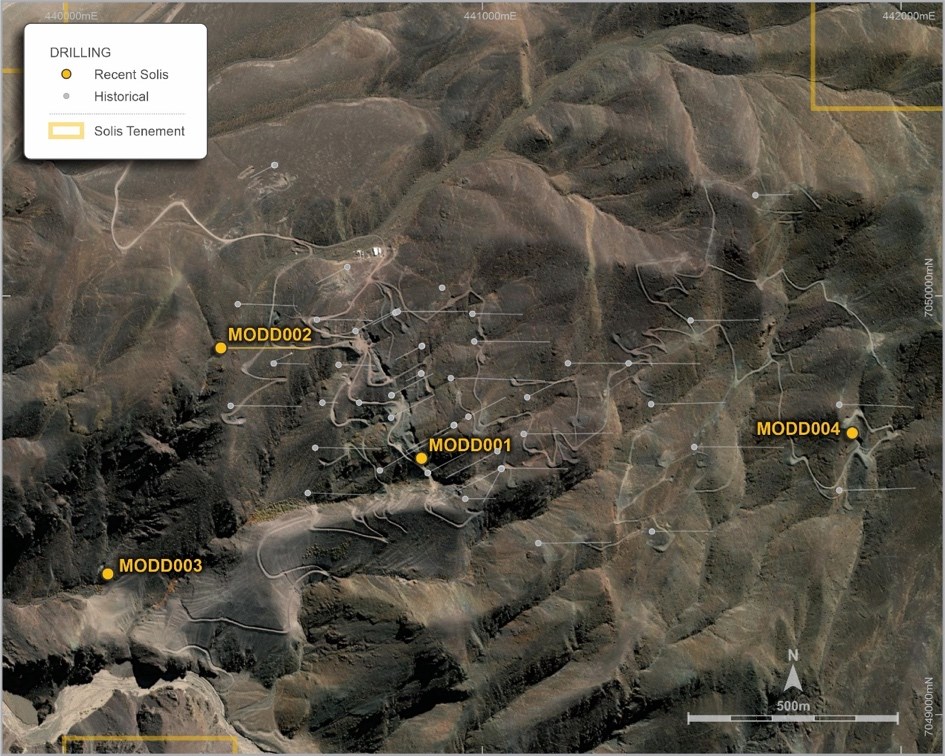
Figure 1: Mostazal Copper Project - Solis Minerals Ltd. diamond drill hole location plan
To view an enhanced version of Figure 1, please visit:
https://orders.newsfilecorp.com/files/1134/119621_1f2cd6ec9408690b_002full.jpg

Figure 2: Hole 4 - Chalcocite veining encountered at depth of 35m
To view an enhanced version of Figure 2, please visit:
https://orders.newsfilecorp.com/files/1134/119621_1f2cd6ec9408690b_003full.jpg

Figure 3: Excavations made by artisanal miners near MODD004 showing the presence of copper oxide mineralisation (green staining)
To view an enhanced version of Figure 3, please visit:
https://orders.newsfilecorp.com/files/1134/119621_1f2cd6ec9408690b_004full.jpg
Next Steps
While the Company awaits assays from the first four holes, it is currently conducting a more detailed and deeper-penetrating geophysical program, together with detailed structural and geological mapping, which, when combined with the pending assay results, will refine the targeting strategy for the second round of drilling at Mostazal.
Southernrock Geophysics based in Santiago, Chile has been engaged to conduct a geophysical survey, consisting of 12.9 line kilometres of Pole-Dipole Induced Polarisation ("PDIP") and Magnetotellurics ("MT"), and an additional 10.5 line kilometres of MT over previously surveyed IP lines. The program of combined PDIP and MT is now underway; the PDIP will provide resistivity and chargeability sections to an effective depth of investigation well below 500m from surface, while the MT will allow much deeper resistivity sections. This survey is expected to be completed by mid-April.

Figure 4: Mostazal Copper Project area, with proposed PDIP-MT survey lines (green), MT only lines (blue), property outline (in red)
To view an enhanced version of Figure 4, please visit:
https://orders.newsfilecorp.com/files/1134/119621_1f2cd6ec9408690b_005full.jpg
This survey is designed to produce higher-fidelity modelling of the interpreted deep mineralised feeder system along the four-kilometre northeast trending IP chargeability zone identified in historic work. The survey will also provide a more comprehensive and deeper penetrating data set for the entire project area which will enhance the identification of both existing and new deep targets.
The Company has begun the drill permitting process for its second phase in anticipation of the resumption of drilling.
The high level of exploration activity across the industry, as well as ongoing impacts of COVID and the pressures that has placed on workforces and service providers has meant assays for the first holes are yet to be received by the Company. The Company is confident we will start to see these results in the next few weeks.
About Solis Minerals Ltd.
Solis Minerals is a Latin American-focused mining exploration company. The Company may earn up to a 100% interest in the Mostazal Copper Project in Chile's Atacama Desert, one of the world's premier copper production jurisdictions. The Company also holds a 100% interest in a package of highly prospective IOCG (iron oxide copper/gold) and porphyry copper projects in southwestern Peru within the country's prolific coastal copper belt - a source of nearly half of Peru's copper production.
Issued on the directive of the board of Solis.
For further information please contact:
Jason Cubitt
President and CEO
Solis Minerals Ltd.
+01 (604) 209 1658
Stephen Moloney
Investor Relations
Corporate Storytime
+61 (0)403 222 052
Neither the TSX Venture Exchange nor its Regulation Service Provider (as the term is defined in the policies of the TSX Venture Exchange) accepts responsibility for the adequacy of accuracy of this news release.
Forward-Looking Statements
This news release contains certain forward-looking statements, which relate to future events or future performance and reflect management's current expectations and assumptions. Such forward-looking statements reflect management's current beliefs and are based on assumptions made by and information currently available to the Company. Readers are cautioned that these forward-looking statements are neither promises nor guarantees, and are subject to risks and uncertainties that may cause future results to differ materially from those expected including, but not limited to, market conditions, availability of financing, actual results of the Company's exploration and other activities, environmental risks, future metal prices, operating risks, accidents, labour issues, delays in obtaining governmental approvals and permits, and other risks in the mining industry. All the forward-looking statements made in this news release are qualified by these cautionary statements and those in our continuous disclosure filings available on SEDAR at www.sedar.com. These forward-looking statements are made as of the date hereof and the Company does not assume any obligation to update or revise them to reflect new events or circumstances save as required by applicable law.
Qualified Person Statement
Fred Tejada, P. Geo. (30021), is a qualified person and a consultant to the Company and has reviewed and approved the technical content of this news release.
Competent Person Statement
The information in this ASX release in relation to Geological Information and Exploration Results is based on and fairly represent information compiled by Mr Anthony Greenaway, a Competent Person who is a Member of the Australasian Institute of Mining and Metallurgy. Mr Greenaway is an employee of Solis Minerals Ltd. and has sufficient experience which is relevant to the style of mineralisation and types of deposit under consideration and to the exploration activities undertaken to qualify as a Competent Person as defined in the 2012 Edition of the "Australian Code for Reporting of Mineral Resources and Ore Reserves". Mr Greenaway consents to the inclusion in this report of the matters based on information in the form and context in which it appears. Mr Greenaway has provided his prior written consent as to the form and context in which the Geological Information and Exploration Results and supporting information are presented in this Announcement.
All information relating to exploration results that have been previously released to the market is appropriately referenced in this document.
APPENDIX 1
Table 1
Mostazal Copper Project Drill Collar Table
| Hole ID | Hole Status | East (m) | North (m) | RL (m) | Planned (m) | EOH (m) | DIP | AZI |
| MODD001 | Complete | 440,853 | 7,049,571 | 2748 | 500 | 362.0 | -90 | 0 |
| MODD002 | Complete | 440,374 | 7,049,835 | 2760 | 500 | 494.7 | -65 | 90 |
| MODD003 | Complete | 440,103 | 7,049,295 | 2521 | 500 | 528 | -90 | 0 |
| MODD004 | Complete | 441,881 | 7,049,630 | 2949 | 500 | 446.1 | -90 | 0 |
Table 2
Visual Estimates of Sulphide Mineralisation
| Hole ID | Depth From (m) | Depth To (m) | Interval (m) | Mineralisation Style | Sulphide Mineralisation | Estimated Sulphide % |
| MODD004 | 1.70 | 3.90 | 2.2 | Fractures (ox); vnlts (sulph) and amygdales | Chalcopyrite>bornite>>chalcocite | Tr |
| MODD004 | 24.50 | 30.50 | 6 | Fractures (ox); vnlts (sulph) and amygdales | Bornite-chalcocite | Tr |
| MODD004 | 30.50 | 31.60 | 1.1 | Vnlts and amygdales | Bornite-chalcocite | Tr-1% |
| MODD004 | 31.60 | 33.00 | 1.4 | Fractures (ox); vnlts (sulph) and amygdales | Bornite-chalcocite | Tr-1% |
| MODD004 | 33.00 | 34.50 | 1.5 | Fractures (ox); vnlts (sulph) and amygdales | Bornite-chalcocite | Tr-1% |
| MODD004 | 34.50 | 35.90 | 1.4 | Fractures (ox); vnlts (sulph) and amygdales | Bornite-chalcocite | 1-5% |
| MODD004 | 35.90 | 41.60 | 5.7 | Vnlts and amygdales | Bornite-chalcocite | Tr |
| MODD004 | 41.60 | 46.40 | 4.8 | Sulphide traces in calcite veins and amygdales | Bornite-chalcocite-pyrite>chalcopyrite | Tr |
| MODD004 | 46.40 | 51.00 | 4.6 | Vnlts and amygdales | Bornite-chalcocite-pyrite>chalcopyrite | Tr |
| MODD004 | 51.00 | 56.15 | 5.15 | Vnlts and amygdales | Bornite-chalcocite-pyrite>chalcopyrite | Tr |
| MODD004 | 56.15 | 58.60 | 2.45 | Vnlts and amygdales | Bornite-Chalcocite-pyrite>chalcopyrite | Tr |
| MODD004 | 59.27 | 60.00 | 0.73 | Vnlts and amygdales | Bornite-chalcocite-pyrite>chalcopyrite | Tr |
| MODD004 | 60.00 | 63.90 | 3.9 | Vnlts and amygdales | Bornite-chalcocite-pyrite>chalcopyrite | Tr |
| MODD004 | 63.90 | 67.80 | 3.9 | Vnlts and amygdales | Bornite-chalcocite-pyrite>chalcopyrite | Tr |
| MODD004 | 67.80 | 70.30 | 2.5 | Vnlts and amygdales | Bornite-chalcocite-pyrite>chalcopyrite | Tr |
| MODD004 | 72.15 | 84.80 | 12.65 | Vnlts and amygdales | Bornite-chalcocite-pyrite>chalcopyrite | Tr |
| MODD004 | 86.40 | 94.80 | 8.4 | Vnlts and amygdales | Bornite-chalcocite-pyrite>chalcopyrite | Tr |
| MODD004 | 94.80 | 100.80 | 6 | Vnlts and amygdales | Bornite-chalcocite-pyrite>chalcopyrite | Tr |
| MODD004 | 100.80 | 101.15 | 0.35 | Vnlts and amygdales | Bornite-chalcocite-pyrite>chalcopyrite | Tr |
| MODD004 | 101.15 | 108.00 | 6.85 | Vnlts and amygdales | Bornite-chalcocite-pyrite>chalcopyrite | Tr |
| MODD004 | 113.00 | 118.00 | 5 | Vnlts and amygdales | Bornite-chalcocite-pyrite>chalcopyrite | Tr |
| MODD004 | 124.20 | 128.94 | 4.74 | Vnlts and amygdales | Bornite-chalcopyrite | Tr |
| MODD004 | 128.94 | 133.40 | 4.46 | Amygdales | Bornite > chalcopyrite | Tr |
| MODD004 | 128.94 | 134.33 | 5.39 | disseminated in cement of breccia | Bornite >> chalcopyrite | 1-5% |
| MODD004 | 134.33 | 143.15 | 8.82 | amygdales > veinlets | Bornite > > chalcopyrite | Tr |
| MODD004 | 146.40 | 149.10 | 2.7 | Amygdales | Bornite | Tr |
| MODD004 | 151.65 | 158.71 | 7.06 | Amygdales + veinlets | Bornite > chalcopyrite | Tr-1% |
| MODD004 | 158.71 | 163.97 | 5.26 | On fractures >> disseminated | Chalcopyrite > bornite | Tr |
| MODD004 | 163.97 | 164.60 | 0.63 | Amygdales + veinlets | Bornite | Tr-1% |
| MODD004 | 164.60 | 165.00 | 0.4 | Disseminated in breccia cement | Chalcopyrite > chalcocite | Tr |
| MODD004 | 165.00 | 168.24 | 3.24 | 0 | ||
| MODD004 | 168.24 | 169.50 | 1.26 | Amygdales | Chalcocite - bornite | Tr |
| MODD004 | 169.50 | 185.45 | 15.95 | On fracs | Chalcopyrite | Local tr |
| MODD004 | 185.45 | 188.40 | 2.95 | Disseminated > veinlets | Chalcopyrite | Tr |
| MODD004 | 188.40 | 190.23 | 1.83 | Amygdales | Bornite >> chalcopyrite | Tr-1% |
| MODD004 | 190.23 | 192.40 | 2.17 | Amygdales | Chalcopyrite >> chalcocite | Tr |
| MODD004 | 192.40 | 196.00 | 3.6 | Amygdales + veinlets | Bornite > chalcocite | Tr-1% |
| MODD004 | 196.00 | 196.50 | 0.5 | Amygdales | Chalcopyrite | Tr-1% |
| MODD004 | 197.00 | 197.33 | 0.33 | Disseminated | Chalcopyrite | Tr-1% |
| MODD004 | 197.80 | 198.40 | 0.6 | Amygdales >> veinlets | Bornite > chalcocite | Tr-1% |
| MODD004 | 198.40 | 200.20 | 1.8 | Amygdales | bornite | Tr |
| MODD004 | 200.20 | 201.00 | 0.8 | Veinlets | Chalcopyrite > bornite >> chalcocite | Tr-1% |
| MODD004 | 201.00 | 205.65 | 4.65 | Amygdales | Bornite > chalcopyrite | Tr |
| MODD004 | 205.65 | 207.10 | 1.45 | Veinlets > disseminated | Bornite > chalcopyrite | Tr-1% |
| MODD004 | 207.10 | 212.00 | 4.9 | Veinlets + disseminated | Bornite > chalcopyrite >> chalcocite | Tr |
| MODD004 | 212.00 | 213.00 | 1 | Amygdales | Bornite > chalcopyrite | Tr-1% |
| MODD004 | 213.00 | 214.49 | 1.49 | Amygdales | Chalcopyrite >> bornite | Tr-1% |
| MODD004 | 214.49 | 216.00 | 1.51 | Amygdales | Chalcopyrite >> chalcocite | Tr |
| MODD004 | 216.00 | 217.00 | 1 | Amygdales | Chalcocite | Tr |
| MODD004 | 217.00 | 219.10 | 2.1 | Amygdales | Chalcopyrite > chalcocite | Tr |
| MODD004 | 219.10 | 221.00 | 1.9 | In small hydrothermal breccia and amygdales | Chalcopyrite >> bornite | Tr |
| MODD004 | 221.00 | 224.83 | 3.83 | Disseminated + fracs (with chlorite) | Chalcopyrite | Tr |
| MODD004 | 224.83 | 228.10 | 3.27 | Amygdales | Chalcopyrite + bornite | Tr |
| MODD004 | 228.10 | 230.00 | 1.9 | Amygdales | Chalcopyrite + bornite | Tr |
| MODD004 | 230.00 | 231.30 | 1.3 | Amygdales | Bornite, chalcopyrite | Tr |
| MODD004 | 232.00 | 233.75 | 1.75 | amygdales > veinlets | Bornite | Tr |
| MODD004 | 240.10 | 244.60 | 4.5 | Amygdales + diss. | Bornite > chalcopyrite > chalcocite | Tr |
| MODD004 | 244.60 | 247.05 | 2.45 | Amygdales | Bornite >> chalcocite | Tr |
| MODD004 | 247.05 | 248.88 | 1.83 | Amygdales | Bornite, chalcopyrite | Tr |
| MODD004 | 248.88 | 249.15 | 0.27 | Amygdales | Bornite > chalcocite | Tr-1% |
| MODD004 | 249.15 | 250.90 | 1.75 | Amygdales | Chalcopyrite | Tr |
| MODD004 | 250.90 | 252.20 | 1.3 | Disseminated and in narrow stringers | Chalcopyrite | Tr |
| MODD004 | 252.20 | 253.34 | 1.14 | Disseminated an in veinlets | Chalcopyrite, pyrite | Tr |
| MODD004 | 253.34 | 253.70 | 0.36 | Veinlet | chalcopyrite | Tr |
| MODD004 | 262.77 | 266.06 | 3.29 | Disseminated (very local) | Bornite - chalcocite | Tr |
| MODD004 | 266.06 | 269.25 | 3.19 | Disseminated | Chalcopyrite; sphalerite (?) | Tr |
| MODD004 | 285.00 | 287.20 | 2.2 | Amygdales > veinlets | Bornite > chalcocite | Tr |
| MODD004 | 302.43 | 311.00 | 8.57 | Disseminated in amygdales and breccias | Bornite >> chalcopyrite > chalcocite | Tr |
| MODD004 | 312.10 | 318.10 | 6 | Amygdales | Bornite > chalcocite | Tr |
| MODD004 | 319.75 | 330.34 | 10.59 | Disseminated (very local) | Chalcopyrite | Tr |
| MODD004 | 330.34 | 334.57 | 4.23 | Disseminated >> veinlets | Chalcopyrite >> bornite | Tr |
| MODD004 | 334.57 | 341.20 | 6.63 | Disseminated | Chalcopyrite >> bornite | Tr |
| MODD004 | 341.20 | 347.65 | 6.45 | Amygdales >> veinlets | Chalcopyrite >> bornite | Tr-1% |
| MODD004 | 347.65 | 348.10 | 0.45 | Amygdales | Chalcopyrite | Tr-1% |
| MODD004 | 348.10 | 355.24 | 7.14 | Disseminated (very local) | Chalcopyrite | Tr |
| MODD004 | 355.24 | 358.85 | 3.61 | Disseminated (very local) | Chalcopyrite | Tr |
| MODD004 | 358.85 | 361.70 | 2.85 | Amygdales (close to the lower contact only) | Chalcopyrite | Tr |
| MODD004 | 341.20 | 374.53 | 33.33 | Amygdales | Chalcopyrite | Tr |
| MODD004 | 379.00 | 380.58 | 1.58 | veinlets (with chlorite) + disseminated | Chalcopyrite | Tr |
| MODD004 | 381.29 | 391.21 | 9.92 | Amygdales > veinlets | Chalcopyrite | Tr-1% |
| MODD004 | 391.21 | 392.10 | 0.89 | Amygdales > veinlets | Chalcopyrite | Tr-1% |
| MODD004 | 392.10 | 398.00 | 5.9 | Amygdales | Bornite, chalcopyrite | Tr-1% |
| MODD004 | 399.54 | 401.42 | 1.88 | Amygdales | Chalcopyrite | Tr5 |
| MODD004 | 401.42 | 405.14 | 3.72 | Amygdales | Chalcopyrite | Tr |
| MODD004 | 405.14 | 408.89 | 3.75 | Amygdales | Chalcopyrite | Tr |
| MODD004 | 408.89 | 415.04 | 6.15 | Amygdales | Chalcopyrite | Tr |
| MODD004 | 415.04 | 416.82 | 1.78 | Amygdales | Chalcopyrite | Tr |
| MODD004 | 416.82 | 424.88 | 8.06 | Amygdales | Chalcopyrite | Tr |
| MODD004 | 424.88 | 430.55 | 5.67 | Amygdales | Pyrite > chalcopyrite | Tr-1% |
| MODD004 | 430.55 | 436.80 | 6.25 | Amygdales | Pyrite >> chalcopyrite | Tr-1% |
| MODD004 | 436.80 | 440.20 | 3.4 | Diss. and in amygdales | Pyrite | Tr-1% |
| MODD004 | 440.20 | 442.40 | 2.2 | Amygdales and fractures | Pyrite | Tr |
| MODD004 | 443.00 | 446.10 | 3.1 | Amygdales | Pyrite | Tr-1% |
Cautionary note:
The Company stresses that the reported visually estimated percentages in Table 2 above, relate specifically to the abundance of sulphides logged in the drill core and is not an estimated grade for the interval.
In relation to the disclosure of visual results, the Company cautions that visual estimates of mineral abundance should never be considered a proxy or substitute for a laboratory analysis. Assay results are required to determine the widths and grade of the visual mineralisation in preliminary geological logging. The Company will update the market when laboratory results become available.

Figure 5: Mostazal Copper Project location
To view an enhanced version of Figure 5, please visit:
https://orders.newsfilecorp.com/files/1134/119621_1f2cd6ec9408690b_006full.jpg
APPENDIX 2
JORC Code, 2012 Edition - Table 1
Section 1 Sampling Techniques and Data
(Criteria in this section apply to all succeeding sections)
| Criteria | JORC Code explanation | Commentary |
| Sampling techniques |
|
|
| Drilling techniques |
|
|
| Drill sample recovery |
|
|
| Logging |
|
|
| Sub-sampling techniques and sample preparation |
|
|
| Quality of assay data and laboratory tests |
|
|
| Verification of sampling and assaying |
|
|
| Location of data points |
|
|
| Data spacing and distribution |
|
|
| Orientation of data in relation to geological structure |
|
|
| Sample security |
|
|
| Audits or reviews |
|
|
Section 2 Reporting of Exploration Results
(Criteria listed in the preceding section also apply to this section)
| Criteria | JORC Code explanation | Commentary |
| Mineral tenement and land tenure status |
|
|
| Exploration done by other parties |
|
|
| Geology |
|
|
| Drill hole Information |
|
|
| Data aggregation methods |
|
|
| Relationship between mineralisation widths and intercept lengths |
|
|
| Diagrams |
|
|
| Balanced reporting |
|
|
| Other substantive exploration data |
|
|
| Further work |
|
|
[1] Refer to Appendix 1 Table 2
To view the source version of this press release, please visit https://www.newsfilecorp.com/release/119621
Source: Solis Minerals Ltd.