Vancouver, British Columbia--(Newsfile Corp. - June 28, 2019) - Rise Gold Corp. (CSE: RISE) (OTCQB: RYES) (the "Company") is pleased to announce the successful completion of the initial surface exploration drilling program, the estimation of a significant Initial Exploration Target based on recent exploration drilling, and the Company's strategy to advance the Idaho-Maryland ("I-M") Gold Project towards the re-opening of the mine.
The Company has completed 19 drill holes, totalling 20,584 meters, over the past 20 months in the Company's initial surface exploration drilling program at the Idaho-Maryland Gold Project.
Drilling has confirmed the presence of significant extensions of previously mined veins and structures. Numerous high-grade gold intercepts have been encountered, both near the existing mine workings and to depths of over 1 km below historic mining areas.
The Company has calculated an Initial Exploration Target based on Rise Gold's exploration drill results supported by historic data from the Idaho-Maryland Gold Project. The initial target represents the mineralized material in close proximity to and accessible from the existing mine workings that can be readily drilled from surface and/or underground to define a mineral resource.
The Initial Exploration Target provides a basis for the engineering required to permit and plan for the re-opening of Idaho-Maryland Mine. The Company is now focusing its resources on engineering work to advance the project. The Company has temporarily curtailed surface exploration drilling.
The Company has commenced engineering work to support an application for a Use Permit from Nevada County to allow the following activities:
- Dewatering of the underground mine workings.
- Underground exploration drilling.
- Full commercial mining with onsite mineral processing at the historic throughput of 1,000 tons per day.
Information on regulatory and environmental aspects of the Idaho-Maryland Gold Project was previously released on May 17, 20191.
The Initial Exploration Target is estimated to range between 2,280,000 tons - 3,410,000 tons of mineralized material, as detailed in Table 1. Approximately 50% of the mineralized material is hosted in wide zones, estimated to average ~29 feet (9 m) in true width, and potentially amenable to high productivity sub level long hole mining methods. The remaining mineralized material is estimated to average ~10 feet (3 m) in true width and would likely require more selective mining methods such as cut and fill mining.
The grade of this mineralized material cannot reliably be estimated without more extensive sampling. However, Rise Gold's drill core assays in conjunction with historic geological information show high grade gold values similar to grades that were encountered in historic operations at the Idaho-Maryland Mine.
Past production of the Idaho-Maryland for the period from 1866 to 1955 is estimated at 2,414,000 oz of gold at an average mill head grade of 0.50 oz per ton (17 grams per tonne) gold. Over the five years from 1937-1941 before the mine was forced to shutdown during WWII, the mine produced an average of 941 tons per day at an average head grade of 0.34 oz per ton (11.6 grams per tonne) and 116,000 oz gold per year2.
The Company cautions investors that the potential quantity and grade of the Initial Exploration Target is conceptual in nature and there has been insufficient exploration to define a mineral resource. The exploration target therefore does not represent, and should not be construed to be, an estimate of a mineral resource or mineral reserve. It is uncertain if further exploration will result in the target being delineated as a mineral resource.
The Initial Exploration Target is derived from Rise Gold's drill intercepts where geology can be correlated to historic workings. Many of Rise Gold's recent drill intercepts are excluded from the estimate until further drilling can allow the full and reliable interpretation of this data. An exceptionally high gold intercept encountered below the modeled exploration target in drill hole I-18-10 was excluded from the Initial Exploration Target. This interval assayed 4.35 oz per ton gold over 22.4 feet and included 63.85 oz per ton gold over 1.5 ft. This high-grade interval may represent a new and significant high-grade discovery but further drilling in this area is required to understand the orientation and nature of the mineralization.
Numerous known veins shown by historic drilling and mapping, pillars, and broken ore inventory in historic shrinkage stopes are excluded from the Initial Exploration Target. The Company believes there is significant potential in these tertiary targets that will be best targeted, in the future, from underground.
The large mineral potential to depth, as described in Rise Golds news release dated May 21st 20193, is not included in the Initial Exploration Target and justifies extensive exploration. The Company believes that the potential for gold mineralization to depth is very significant and that it may be possible to delineate resources similar to or greater than the past production achieved at the Idaho-Maryland Mine.
TABLE 1 - Initial Exploration Target Summary
| Tons Mineralized Material | Estimated True Width | |||||
| Block | Zone | Level | Low Case | Base Case | feet | meters |
| A | Idaho #2 | I2700L - B3280L | 540,000 | 810,000 | 33 | 10.1 |
| B | Idaho #2 | I2700L | 200,000 | 300,000 | 16 | 4.9 |
| C | Idaho #2 - Splays | I2400L | 170,000 | 250,000 | 8 | 2.4 |
| D | Idaho #1 Morehouse | I2400L - B3280 L | 170,000 | 250,000 | 8 | 2.4 |
| E | Idaho #1 | I2400L - B3280 L | 320,000 | 480,000 | 8 | 2.4 |
| F | Brunswick #1 | B1600L - B1880L | 290,000 | 440,000 | 26 | 7.9 |
| G | Brunswick #32 | B1300L-B1880L | 120,000 | 180,000 | 11 | 3.3 |
| H | Brunswick #10HW | B1600L - B1880L | 80,000 | 120,000 | 8 | 2.5 |
| I | Brunswick #10 FW | B1600L - B1880L | 90,000 | 130,000 | 9 | 2.7 |
| J | Brunswick #41 | B1880L - B2650L | 300,000 | 450,000 | 23 | 6.9 |
| TOTAL | 2,280,000 | 3,410,000 | ||||
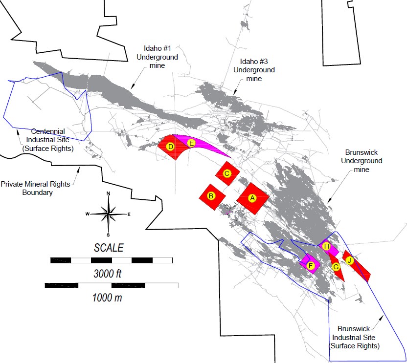
FIGURE 1 - Location of Areas Included in Initial Exploration Target
To view an enhanced version of Figure 1, please visit:
https://orders.newsfilecorp.com/files/2255/45965_d51dd87554873972_002full.jpg
IDAHO #2 VEIN & RECENT DRILL RESULTS
Recent drill hole I-19-14A provided important geological information to prepare a substantial exploration target estimate for a portion of the Idaho #2 Vein. This zone of mineralization is estimated to have a true width of ~33 ft (10 m) and range in size from 540,000 - 800,000 tons.
Drill hole I-19-14A assayed 1.4 gpt gold over 14.9 m (0.04 oz per ton / 49.1 ft) including 6.2 gpt gold over 1.9 m (0.18 oz per ton / 6.3 feet).
Information from Drill hole I-19-14A provides geological context to previous intersections and historic information in this area of the Idaho #2 Vein. Drilling shows two important veins of the Idaho #2 zone which should be composited into a single zone.
Therefore, the previously released intersection for this area from drill hole I-19-13A is restated as 27.1 gpt gold over 14.8 m (0.79 oz gold per ton over 48.7 feet) with a true width of 14.1 m (46.4 ft). All drill hole intersections in this area of the Idaho #2 Vein are shown in Table 3.
A diabase dike is consistently present in the hanging wall of the mineralized zone. A gold-quartz vein is present immediately adjacent to the diabase (hanging wall vein). A second vein is separated from the hanging wall vein by approximately 18 ft (the center vein). The rock between the two veins is intensely altered and contains persistent but lower grade gold values. A weaker vein (footwall vein), occurs at a distance of approximately 20 ft from the center vein.
Historic drill hole I-2800-5 shows a similar style of mineralization with a hanging wall, center, and footwall vein. The historic operator did not assay the mineralized material between the veins and therefore 31 feet of the 63-foot mineralized interval in historic drill hole I-2800-5 is assigned a zero-gold grade.
Drill hole I-19-13 and I-19-13A are closely spaced, approximately 1.5 m (5 ft) apart, and show consistent geology but differ in grade substantially due to the coarse nature of the gold occurrence in this zone. For example, a section of the center vein in I-19-13A assayed 458 gpt gold over 0.81 m (13.35 oz per ton gold / 2.7 feet) and showed coarse gold in the retained half of the drill core as shown in Figure 2. The corresponding sample from I-19-13 assayed 12.5 gpt gold over 0.85 m (0.36 oz per ton gold / 2.8 feet). Rise Gold geologists inspected the retained half core from the corresponding I-19-13 interval and noted gold just below the surface of the drill core. This retained sample was split and revealed coarse gold present (shown in Figure 3), which may have resulted in a much higher assay if the entire core was submitted for assay.
Drill hole I-19-14A intersected the Idaho #2 Vein ~25.9 m (~85 feet) north of the mineralized intervals in drill holes I-19-13 and I-19-13A.
Drill hole I-19-14 intersected the Idaho #2 Vein 19.8 m (~65 feet) north of I-19-14A. The vein shows a sharp change in strike in this location, mirroring the historic drifting above on the I2700 level, and results in a significant decrease in vein widths, intensity of alteration, and gold grades. Based on historic records from the I2700 level above, it is suspected that gold grades may improve as the strike of the Idaho #2 Vein turns towards the Idaho #3 Vein, approximately 70 m (230 ft) north of the I-19-14 intercept.
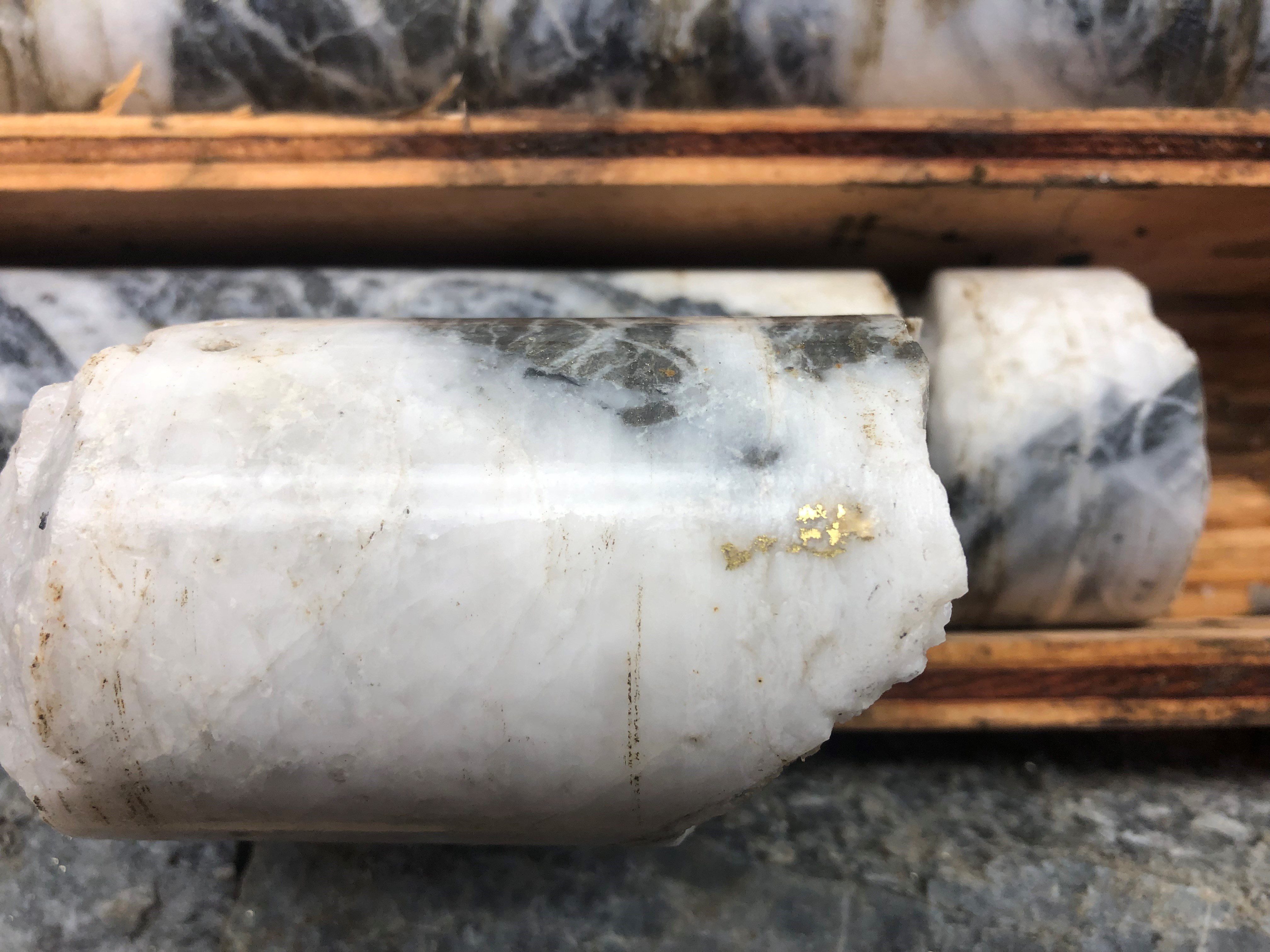
FIGURE 2 - Visible Gold in Drill Intercept I-19-13A (in retained half core)
(Assayed 13.35 oz per ton / 2.7 feet)
To view an enhanced version of Figure 2, please visit:
https://orders.newsfilecorp.com/files/2255/45965_d51dd87554873972_003full.jpg

FIGURE 3 - Visible Gold in Drill Intercept I-19-13 (in retained half core)
(Assayed 0.36 oz per ton / 2.8 feet)
To view an enhanced version of Figure 3, please visit:
https://orders.newsfilecorp.com/files/2255/45965_d51dd87554873972_005full.jpg
INITIAL EXPLORATION TARGET
The Company prepared an estimate of potential tonnages for a number of exploration targets where recent drill results can be correlated with historic geology and operational data. Each zone was modelled using Rise Gold's drill hole information along with historic mapping and historic drilling where it was available. To account for uncertainty in geometry, a low case value of 67% of the base case value is presented in the exploration target summary. The historic mineralized material density of 12 ft3 / ton was used for tonnage estimates.
The Initial Exploration Target only includes mineralization above the B3280 level which is the lowest level of the existing historic mine. Rise Gold has drilled several important intersections much deeper than the B3280 level which suggests important gold mineralization extends well below the B3280 level. The historic operator also anticipated that gold mineralization continued well below the B3280 level and invested significant capital to upgrade the mine hoist and was actively sinking the shaft towards the 5000 ft level below surface. The historic operator reached a depth of 3470 ft below surface when the mine was forced to close in 1942.
Drawings showing the location and geometry of the zones included in the Initial Exploration Target can be downloaded from the following link. All drawings are in imperial units and shown in mine grid coordinates. The mine grid uses an elevation of 10,000 ft as the datum for sea level. Mine grid north is similar to true north.
https://riseg.sharefile.com/d-s59c224538744036b
The estimated dimensions used for the calculation of the Initial Exploration Target is displayed in Table 2. Drill intersections used for the modelling of the Initial Exploration target are displayed in Table 3 through Table 5. Important Rise Gold drill intersections which were excluded from the Initial Exploration Target are presented in Table 6.
TABLE 2 - Estimated Dimensions for Initial Exploration Target
| Estimated | |||||
| Block | Zone | Strike Length (ft) | Dip Length (ft) | True Width (ft) | Dip (deg) |
| A | Idaho #2 | 574 | 510 | 33 | 30 |
| B | Idaho #2 | 454 | 485 | 16 | 0 (flat) |
| C | Idaho #2 - Splays | 454 | 421 | 2 x 8 = 16 | 0 (flat) |
| D | Idaho #1 Morehouse | 497 | 754 | 8 | 35 |
| E | Idaho #1 | 1340 | 533 | 8 | 45 - 90 |
| F | Brunswick #1 | 438 | 461 | 26 | 35 |
| G | Brunswick #32 | 300 | 659 | 11 | 60 |
| H | Brunswick #10HW | 480 | 378 | 8 | 60 |
| I | Brunswick #10 FW | 480 | 378 | 9 | 60 |
| J | Brunswick #41 | 222 | 1085 | 23 | 45 |
TABLE 3 - Rise Gold & Historic Drill Intersections within Idaho #2 Initial Exploration Target
| Hole | From (ft) | To (ft) | From (m) | To (m) | Gold (gpt) | Gold (oz per ton) | Intercept Length (ft) | Intercept Length (m) | Estimated True Width (ft) | Estimated True Width (m) | Vein |
| I-19-13 | 3273.0 | 3323.8 | 997.60 | 1013.09 | 2.9 | 0.09 | 50.9 | 15.50 | 44.75 | 13.64 | I2 - Bk-A |
| Including | 3307.0 | 3323.8 | 1007.97 | 1013.09 | 5.5 | 0.16 | 16.8 | 5.12 | 14.78 | 4.51 | center vn |
| I-19-13A | 3263.6 | 3312.3 | 994.75 | 1009.57 | 27.0 | 0.79 | 48.7 | 14.83 | 46.40 | 14.14 | I2 - Bk-A |
| Including | 3298.3 | 3312.3 | 1005.31 | 1009.57 | 90.4 | 2.63 | 14.0 | 4.27 | 13.35 | 4.07 | center vn |
| Including | 3309.6 | 3312.3 | 1008.77 | 1009.57 | 458.0 | 13.35 | 2.7 | 0.81 | 2.53 | 0.77 | center vn |
| I-19-14A | 3328.2 | 3377.0 | 1014.42 | 1029.31 | 1.4 | 0.04 | 48.8 | 14.89 | 44.60 | 13.59 | I2 - Bk-A |
| Including | 3328.2 | 3334.5 | 1014.42 | 1016.36 | 6.2 | 0.18 | 6.3 | 1.94 | 5.80 | 1.77 | hw vn |
| I-2800-5 (hist) | 348.1 | 411.3 | 106.10 | 125.38 | 6.1 | 0.18 | 63.2 | 19.27 | 20.80 | 6.34 | I2 - Bk-A |
| Including | 348.1 | 358.6 | 106.10 | 109.30 | 7.3 | 0.21 | 10.5 | 3.20 | 3.45 | 1.05 | I2 - Bk-A |
| Including | 381.1 | 400.1 | 116.15 | 121.94 | 13.8 | 0.40 | 19.0 | 5.79 | 6.25 | 1.91 | I2 - Bk-A |
| Including | 408.8 | 411.3 | 124.61 | 125.38 | 19.2 | 0.56 | 2.5 | 0.76 | 0.82 | 0.25 | I2 - Bk-A |
| I-18-10 | 3168.0 | 3189.0 | 965.61 | 972.01 | 3.2 | 0.09 | 21.0 | 6.40 | 18.40 | 5.61 | I2 - Bk-B |
| I-2400-31 (hist) | 623.6 | 668.9 | 190.07 | 203.87 | 11.1 | 0.32 | 45.3 | 13.80 | 13.89 | 4.23 | I2 - Bk-B |
| Including | 634.3 | 664.3 | 193.33 | 202.47 | 16.5 | 0.48 | 30.0 | 9.14 | 9.21 | 2.81 | I2 - Bk-B |
| I-18-11 | 3197.4 | 3204.4 | 974.57 | 976.70 | 10.9 | 0.32 | 7.0 | 2.13 | 5.77 | 1.76 | I2- Bk-C |
| I-18-11 | 3255.4 | 3262.6 | 992.25 | 994.44 | 11.9 | 0.35 | 7.2 | 2.19 | 5.87 | 1.79 | I2- Bk-C |
| Including | 3256.9 | 3258.6 | 992.70 | 993.22 | 35.6 | 1.04 | 1.7 | 0.52 | 1.39 | 0.42 |
TABLE 4 - Historic Drill Intersections & Channels within Idaho #1 Initial Exploration Target
| Hole | From (ft) | To (ft) | From (m) | To (m) | Gold (gpt) | Gold (oz per ton) | Intercept Length (ft) | Intercept Length (m) | Estimated True Width (ft) | Estimated True Width (m) | Vein |
| I-2400 W historic channels | 0.0 | 497.0 | 0.00 | 151.49 | 16.3 | 0.47 | 497.0 | 151.49 | 8.00 | 2.44 | I1 - Mh |
| Including | 0.0 | 37.3 | 0.00 | 11.37 | 37.3 | 1.09 | 37.3 | 11.37 | 8.00 | 2.44 | I1 - Mh |
| Including | 93.2 | 205.1 | 28.41 | 62.51 | 17.7 | 0.52 | 111.9 | 34.11 | 8.00 | 2.44 | I1 - Mh |
| Including | 248.6 | 329.4 | 75.77 | 100.40 | 47.3 | 1.38 | 80.8 | 24.63 | 8.00 | 2.44 | I1 - Mh |
| Including | 317.0 | 329.4 | 96.62 | 100.40 | 187.3 | 5.46 | 12.4 | 3.78 | 8.00 | 2.44 | I1 - Mh |
| I-2400-40 (hist) | 191.1 | 204.5 | 58.25 | 62.33 | 6.5 | 0.19 | 13.4 | 4.08 | 8.54 | 2.60 | I1 |
| Including | 195.7 | 198.4 | 59.65 | 60.48 | 24.0 | 0.70 | 2.7 | 0.82 | 1.72 | 0.52 | |
| I-2400-40 (hist) | 217.1 | 233.1 | 66.17 | 71.05 | 2.9 | 0.08 | 16.0 | 4.88 | 8.85 | 2.70 | I1 |
TABLE 5 - Drill Intersections within Brunswick Initial Exploration Target
| Hole | From (ft) | To (ft) | From (m) | To (m) | Gold (gpt) | Gold (oz per ton) | Intercept Length (ft) | Intercept Length (m) | Estimated True Width (ft) | Estimated True Width (m) | Vein |
| B-17-01 | 2096.1 | 2145.0 | 638.89 | 653.80 | 12.2 | 0.36 | 48.9 | 14.90 | 26.00 | 7.92 | B1 |
| Including | 2112.0 | 2121.0 | 643.74 | 646.48 | 62.7 | 1.83 | 9.0 | 2.74 | 4.79 | 1.46 | B1 Center |
| Including | 2116.0 | 2118.0 | 644.96 | 645.57 | 266.0 | 7.76 | 2.0 | 0.61 | 1.06 | 0.32 | B1 Center |
| B-18-04 | 1696.0 | 1709.2 | 516.94 | 520.96 | 8.0 | 0.23 | 13.2 | 4.02 | 10.80 | 3.29 | B32 |
| Including | 1696.0 | 1699.5 | 516.94 | 518.01 | 23.0 | 0.67 | 3.5 | 1.07 | 2.86 | 0.87 | |
| B-18-04 | 2051.4 | 2060.5 | 625.27 | 628.04 | 4.0 | 0.12 | 9.1 | 2.77 | 7.30 | 2.23 | B10 HW |
| B-18-04 | 2090.0 | 2100.0 | 637.03 | 640.08 | 4.4 | 0.13 | 10.0 | 3.05 | 8.10 | 2.47 | B10 FW |
| B-18-07 | 2449.1 | 2461.1 | 746.49 | 750.14 | 4.0 | 0.12 | 12.0 | 3.66 | 9.10 | 2.77 | B10 HW |
| B-18-07 | 2488.4 | 2501.1 | 758.45 | 762.34 | 2.2 | 0.06 | 12.8 | 3.89 | 9.70 | 2.96 | B10 FW |
| B-18-06 | 2509.5 | 2544.3 | 764.90 | 775.50 | 4.2 | 0.12 | 34.8 | 10.61 | 26.90 | 8.20 | B41 |
TABLE 6 - Important Rise Gold Drill Intersections Excluded from the Initial Exploration Target
| Hole | From (ft) | To (ft) | From (m) | To (m) | Gold (gpt) | Gold (oz per ton) | Intercept Length (ft) | Intercept Length (m) | Estimated True Width (ft) | Estimated True Width (m) | Vein |
| I-18-10 | 3240.7 | 3263.1 | 987.77 | 994.58 | 149.3 | 4.35 | 22.4 | 6.81 | ? | I2 footwall | |
| Including | 3259.3 | 3260.8 | 993.42 | 993.88 | 2190.0 | 63.85 | 1.5 | 0.46 | |||
| B-18-05 | 5212.0 | 5258.0 | 1588.62 | 1602.64 | 8.8 | 0.26 | 46.0 | 14.02 | ? | ? | I2/3 (deep) |
| Including | 5217.0 | 5231.5 | 1590.14 | 1594.56 | 23.7 | 0.69 | 14.5 | 4.42 | ? | ? | |
| Including | 5228.3 | 5229.7 | 1593.59 | 1594.01 | 230.0 | 6.71 | 1.4 | 0.43 | ? | ? | |
| B-18-05 | 6192.5 | 6202.2 | 1887.47 | 1890.43 | 10.9 | 0.32 | 9.7 | 2.96 | ? | ? | I3/5 (deep) |
| Including | 6198.7 | 6200.3 | 1889.36 | 1889.85 | 61.0 | 1.78 | 1.6 | 0.49 | ? | ? | |
| I-19-12B | 4485.8 | 4505.3 | 1367.27 | 1373.22 | 9.4 | 0.27 | 19.5 | 5.95 | ? | ? | I1 (deep) |
| Including | 4485.8 | 4495.1 | 1367.27 | 1370.11 | 18.5 | 0.54 | 9.3 | 2.84 | ? | ? | I1 |
| Including | 4491.6 | 4495.1 | 1369.04 | 1370.11 | 46.3 | 1.35 | 3.5 | 1.07 | ? | ? | I1 |
| Including | 4493.9 | 4495.1 | 1369.74 | 1370.11 | 111.5 | 3.25 | 1.2 | 0.37 | ? | ? | I1 |
| B-18-05 | 3209.0 | 3226.0 | 978.10 | 983.28 | 22.4 | 0.65 | 17.0 | 5.18 | ? | ? | B40? |
| Including | 3209.0 | 3213.0 | 978.10 | 979.32 | 93.2 | 2.72 | 4.0 | 1.22 | ? | ? | |
| B-17-01 | 3647.0 | 3697.0 | 1111.61 | 1126.85 | 4.5 | 0.13 | 50.0 | 15.24 | ? | ? | ? |
| Including | 3648.5 | 3653.5 | 1112.06 | 1113.59 | 40.6 | 1.18 | 5.0 | 1.52 |
Quality Control and Assay Methods
Richard Lippoth, M.Sc, Reg. SME, the qualified person for the exploration drill results disclosure contained in this news release, has studied the drill core discussed in this news release and has reviewed the analytical and quality control results. Mr. Lippoth has reviewed and approved the scientific and technical contents of this news release.
Benjamin Mossman, P.Eng, CEO of Rise Gold, is the qualified person for the historic production disclosure and exploration target estimate contained in this news release. Historic production at the Idaho-Maryland Mine is disclosed in the Technical Report on the Idaho-Maryland Project dated June 1st, 2017 and available on www.sedar.com.
Rise has implemented a quality control program for its drill program to ensure best practice in the sampling and analysis of the drill core. This includes the insertion of blind blanks, duplicates and certified standards. HQ- and NQ-sized drill core is saw cut with half of the drill core sampled at intervals based on geological criteria including lithology, visual mineralization, and alteration. The remaining half of the core is stored on-site at the Company's warehouse in Grass Valley, California. Drill core samples are transported in sealed bags to ALS Minerals analytical assay lab in Reno, Nevada.
All gold assays were obtained using a method of screen fire assaying. This procedure involves screening a large pulverized sample of up to 1 kg at 100 microns. Any +100 micron material remaining on the screen is retained and analyzed in its entirety by fire assay with gravimetric finish and reported as the Au (+) fraction result. The -100 micron fraction is homogenized and two sub-samples of 30-50 grams are analyzed by fire assay with AAS finish. If the grade of the material exceeds 10 gpt the sample is re-assayed using a gravimetric finish. The average of the two results is taken and reported as the Au (-) fraction result. All three values are used in calculating the combined gold content of the plus and minus fractions.
____________________
About Rise Gold Corp.
Rise Gold is an exploration-stage mining company. The Company's principal asset is the historic Idaho-Maryland Gold Mine located in Nevada County, California, USA. Past production of the Idaho-Maryland for the period from 1866 to 1955 is estimated at 2,414,000 oz of gold at an average mill head grade of 17 gpt gold. Historic production at the Idaho-Maryland Mine is disclosed in the Technical Report on the Idaho-Maryland Project dated June 1st, 2017 and available on www.sedar.com. Rise Gold is incorporated in Nevada, USA and maintains its head office in Vancouver, British Columbia, Canada.
On behalf of the Board of Directors:
Benjamin Mossman
President, CEO and Director
Rise Gold Corp.
For further information, please contact:
RISE GOLD CORP.
Suite 650, 669 Howe Street
Vancouver, BC V6C 0B4
T: 604.260.4577
info@risegoldcorp.com
www.risegoldcorp.com
The CSE has not reviewed, approved or disapproved the contents of this news release.
Forward-Looking Statements
This press release contains certain forward-looking statements within the meaning of applicable securities laws. Forward-looking statements are frequently characterized by words such as "plan", "expect", "project", "intend", "believe", "anticipate", "estimate" and other similar words or statements that certain events or conditions "may" or "will" occur.
Although the Company believes that the expectations reflected in the forward-looking statements are reasonable, there can be no assurance that such expectations will prove to be correct. Such forward-looking statements are subject to risks, uncertainties and assumptions related to certain factors including, without limitation, obtaining all necessary approvals, meeting expenditure and financing requirements, compliance with environmental regulations, title matters, operating hazards, metal prices, political and economic factors, competitive factors, general economic conditions, relationships with vendors and strategic partners, governmental regulation and supervision, seasonality, technological change, industry practices, and one-time events that may cause actual results, performance or developments to differ materially from those contained in the forward-looking statements. Accordingly, readers should not place undue reliance on forward-looking statements and information contained in this release. Rise undertakes no obligation to update forward-looking statements or information except as required by law.
To view the source version of this press release, please visit https://www.newsfilecorp.com/release/45965
Source: Rise Gold Corp.