Vancouver, British Columbia--(Newsfile Corp. - March 6, 2023) - Commander Resources Ltd. (TSXV: CMD) ("Commander") is pleased to report that it has received results for its inaugural drill program at the Burn Copper and Gold porphyry project located 100 km north of Smithers, British Columbia (the "Burn Property"). Freeport-McMoRan Mineral Properties Canada Inc. ("Freeport") is earning into the Burn Property and Commander is the operator. Commander completed four drill holes totaling 1,513 metres ("m") from three drill sites in October 2022.
Highlights:
- Burn represents a new greenfields porphyry copper and gold discovery.
- 1,513 metre inaugural drill program.
- Area tested includes a large, exposed, quartz-magnetite stockwork zone, a chargeability (induced polarization) anomaly and a zone of elevated gold in soils.
- Hole BU22-01 returned 50 metres @ 0.11% Cu and 0.20 g/t Au (0.24% CuEq).
- Hole BU22-02 returned 83.5 metres grading 1.08 g/t Au.
- Targets are open in all directions as well as additional untested areas.
Drill hole BU 22-01 encountered two intervals of copper-bearing intrusive including an interval of 50 m grading 0.11% Cu and 0.20 grams gold per tonne ("g/t Au") (0.24% CuEq) starting at 84 m downhole and a gold dominant interval in hole BU22-02 from 4.5 m of 83.5 metres grading 1.08 g/t Au. The Burn Property, which covers 17,675 ha was acquired directly by Commander in 2018 to cover prominent gossans exposed along ridges. The property has seen limited historical exploration and this is the first time the property has been drill tested.
Robert Cameron, President and CEO, stated, "We are very excited with these promising inaugural drill results from the Burn project. This is brand new grassroots copper and gold discovery in a well-established porphyry copper and gold district. It was acquired directly by Commander following a regional data compilation and a single day of ground prospecting, which is a testament to the strength and expertise of our technical team. Our partner, Freeport-McMoRan, recognised the potential and partnered with us at an early stage funding the systematic evaluation of this large tenure package that has culminated in this drill discovery."
The Burn Property is located within the Babine Porphyry belt 70 km north of two past producing mines at Bell and Granisle (Figure 1). Initial work at Burn in 2018 identified widespread phyllic-style alteration with trace amounts of chalcopyrite. There is no record of previous geophysical surveys or drilling. Past work by Commander, funded by Freeport, included a property wide airborne magnetic survey which outlined two prominent circular magnetic rings and several linear magnetic highs that coincide with stocks and dykes of Eocene age. A property-wide sampling program of stream sediment sampling, soil and rock sampling, and geological mapping has identified four alteration zones of which the largest is referred to as the Central zone. The Central zone, is the focus of this year's drill program and is underlain by numerous phases of feldspar-biotite-hornblende porphyry dykes and stocks exhibiting alteration from chlorite to chlorite-magnetite, and moderate quartz-sericite-pyrite (QSP) to intense QSP with local quartz veinlets.
Drill results are presented below in Table 1
Table 1: Drill Hole Summary
| Hole | from (m) | to (m) | Length (m) 1 | Cu % | Au (g/t) | Ag (g/t) | CuEq.2 |
| BU22-01 | 4.0 | 52.0 | 48.0 | 0.11 | 0.05 | 0.59 | 0.14 |
| 84.0 | 134.0 | 50.0 | 0.11 | 0.20 | 0.58 | 0.24 | |
| BU22-02 | 4.5 | 154.0 | 149.5 | 0.66 | 1.85 | ||
| including | 4.5 | 88.0 | 83.5 | 1.08 | 2.47 | ||
| including | 28.0 | 32.0 | 4.0 | 11.1 | 3.88 |
Notes
1: length is core length. True widths are unknown.
2: CuEq.: Copper equivalent is calculated using metals prices ($US) of $3.50/ lb for Cu, $1750/oz for Au and $20/lb for Ag and assumed net metal recoveries of 85% for Cu, 72% for Au and 65% for Ag summarized in the following formula. CuEq % = Cu% + ((Au g/t * (Au recovery / Cu recovery) * (Au $ per oz/ 31.1034768) / (Cu $ per lb* 22.05)) + ((Ag g/t * (Ag recovery / Cu recovery) * (Ag $ per oz/ 31.103) / (Cu $ per lb* 22.05)). Metal prices are not economic parameters and are used solely for determining relative weighting factors in CuEq calculations. Recoveries are arbitrary and informed from peer company practice and documented metallurgical studies of similar nearby deposits. No metallurgical work has been completed at Burn.

Figure 1: Location Map
To view an enhanced version of this graphic, please visit:
https://images.newsfilecorp.com/files/4050/157283_75ccbeb034624a6c_001full.jpg
Discussion of Drill Results
Drill collar locations are presented in Table 2 and drill plans and section are presented in (Figures 2 to 4).
Drill hole BU22-01 and BU22-04
Drill hole BU22-01 was collared at the base of a prominent talus slope that is comprised of intense oxidised and phyllic-altered felspar porphyry intrusive and towards azimuth 022. Its goal was to undercut a partially exposed copper bearing exposure of intense quartz-magnetite stockwork. Two copper intervals were encountered in core including an interval from surface to 48.0 m grading 0.11% Cu with low gold within phyllic-altered intrusive followed by a weakly altered and barren post-mineral dyke and then a 50.0 metre interval grading 0.11% Cu and 0.20 g/t Au (0.24% CuEq). The remainder of the hole was sporadically mineralized to depth.
Drill hole BU22-04 was collared from the same pad as hole BU22-01 towards azimuth 088. It cored mixed feldspar porphyry intrusive, and intrusive breccia before ending in sericite and hornfels sediments. Copper and gold values are generally low to very low throughout except for sporadic 2-metre intervals of slightly elevated tenor.
Drill Hole BU22-02
Drill hole BU22-02 was collared some 1000 m west of hole BU22-01 and was drilled towards azimuth 088. The hole was designed to test and area of exceptionally high gold in soils (3 samples > 1000 ppb Au). It cored 0.66 g/t Au from surface to 149.5 m including a shorter interval from surface to 83.5 m grading 1.08 g/t Au. A high-grade interval at 28 m graded 4.0 m of 11.1 g/t Au. Rock types encountered in core are dominated by felspar porphyry and related intrusive breccia and intermittent dykes of more mafic hornblende felspar porphyry. Gold values correlate closely with the hornblende-bearing units and sericite alteration with pyrite and isolated sphalerite veins up to 1 cm in width.
Drill Hole BU22-03
Drill hole BU22-03 was drilled towards a prominent magnetic feature and encountered low values of copper and gold in phyllic-altered felspar porphyry and hornfels sediments. It bottomed in phyllic-altered sediments.
Table 2: Drill Hole Locations
| HoleID | E_83z9 | N_83z9 | Elev (m) | Azimuth | Dip | Length (m) |
| BU22-01 | 653300 | 6165897 | 1563 | 022 | -60.5 | 304 |
| BU22-02 | 652292 | 6166264 | 1586 | 088 | -60 | 457 |
| BU22-03 | 652710 | 6166552 | 1461 | 188 | -50 | 301 |
| BU22-04 | 653298 | 6165893 | 1563 | 232 | -60.5 | 451 |
Future Work
Compilation of drill results is ongoing. The Company has engaged Condor Consulting to reprocess and refine the airborne magnetic data and to complete parametric magnetic inversions or modelling of the central zone area to guide follow-up drilling. The scale of the follow-up drill program in 2023 is currently being determined but will include follow-up step-outs from the high gold zone encountered in hole BU22-02 and testing of similar magnetic features to those encountered in hole BU22-01.
Summary of Freeport Earn-In Agreement terms.
Freeport has been granted the right to earn up to a 75 % interest in the Burn Property through staged option payments and work expenditures totaling $2,500,000 in exploration expenditures and $560,000 in payments to Commander. Following which the companies would enter a 75% Freeport/25% Commander Joint Venture. On October 6, 2022, the Burn property was expanded by optioning a 100% interest in a seven mineral tenure cells (127 ha.) from private vendors for aggregate payments of $290,000.
QA/QC (Quality Assurance/Quality Control)
Commander's 2022 exploration program was supervised by Stephen Wetherup P. Geo., Commander's Vice President of Exploration. The drill contractor was ITL Drilling of Smithers BC. Half-core NQ (47.6 mm) sawed samples from continuous intervals throughout the reported drill holes were sealed on site and shipped to Bureau Veritas ("BV") labs in Vancouver, BC. where fire assay and multielement analyses were completed. Drill core was crushed, pulverized and analyzed for 48 elements using a four-acid dissolution followed by ICP-MS (MA250) with a 30 g sample analyzed for gold by fire assay and fusion Au by ICP-ES (FA330-Au) with overlimit gold analysed by lead collection fire assay 30g fusion with gravimetric finish (FA530). Blanks and commercially certified reference materials were inserted blind into the sample stream with an overall insertion rate of 10%. Field duplicates representing a quarter core split of the original sample are inserted at 2.5%. In addition, pulp and crush duplicates are inserted by the laboratory. The QAQC results were reviewed and the QA/QC results for the reported drill holes are acceptable.
Qualified Person
Robert Cameron, P. Geo. is a qualified person within the context of National Instrument 43-101 and has read and takes responsibility for the technical aspects of this release. All fieldwork completed to date and on-site supervision of the drill program was by Stephen Wetherup.
About Commander Resources
Commander Resources is a Canadian focused exploration company that has leveraged its success in exploration through a combination of partnerships and sole funded exploration. Commander has a portfolio of base and precious metal projects across Canada. Commander also retains royalties from properties that have been partnered, optioned, or sold.
On behalf of the Board of Directors
Robert Cameron, P. Geo.
President and CEO
For further information, please call:
Robert Cameron, President and CEO
Toll Free: 1-800-667-7866
info@commanderresources.com
@CommanderCMD
www.commanderresources.com
Neither TSX Venture Exchange nor its Regulation Services Provider (as that term is defined in the policies of the TSX Venture Exchange) accepts responsibility for the adequacy or accuracy of this release.
This news release may include forward-looking statements that are subject to risks and uncertainties. All statements within, other than statements of historical fact, are to be considered forward looking. Although the Company believes the expectations expressed in such forward-looking statements are based on reasonable assumptions, such statements are not guarantees of future performance and actual results or developments may differ materially from those in forward-looking statements. Factors that could cause actual results to differ materially from those in forward-looking statements include market prices, exploitation and exploration successes, continued availability of capital and financing, and general economic, market or business conditions. There can be no assurances that such statements will prove accurate and, therefore, readers are advised to rely on their own evaluation of such uncertainties. We do not assume any obligation to update any forward-looking statements except as required under the applicable laws.

Figure 2: Drill Plan Projected on Total Field Magnetics and Au Soil Geochemistry
To view an enhanced version of this graphic, please visit:
https://images.newsfilecorp.com/files/4050/157283_75ccbeb034624a6c_003full.jpg
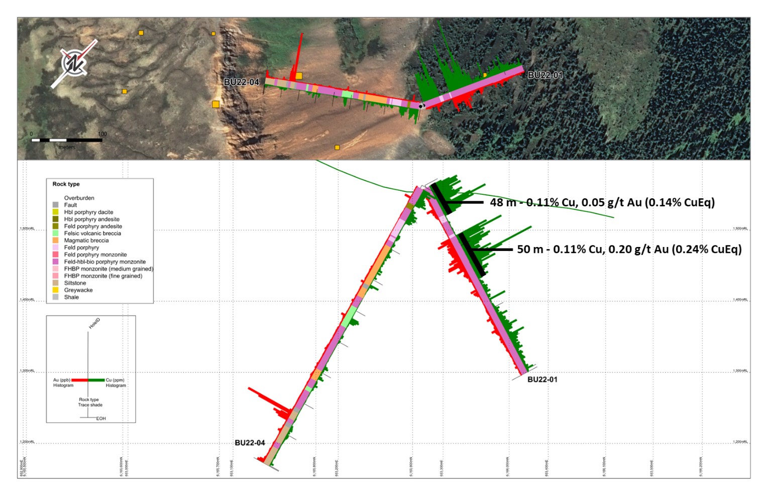
Figure 3: Section BU22-01, BU22-04
To view an enhanced version of this graphic, please visit:
https://images.newsfilecorp.com/files/4050/157283_75ccbeb034624a6c_004full.jpg
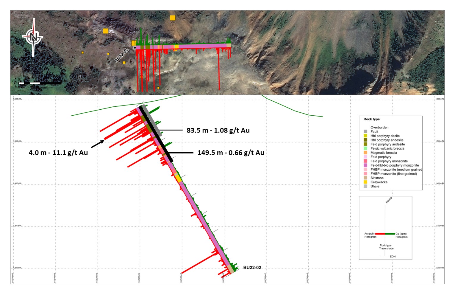
Figure 4: Section BU22-02
To view an enhanced version of this graphic, please visit:
https://images.newsfilecorp.com/files/4050/157283_75ccbeb034624a6c_005full.jpg
![]()
To view the source version of this press release, please visit https://www.newsfilecorp.com/release/157283
Source: Commander Resources Ltd.