Vancouver, British Columbia--(Newsfile Corp. - December 22, 2021) - Cross River Ventures Corp. (CSE: CRVC) (OTCQB: CSRVF) (FSE: C6R) (the "Company") is pleased to announce a 5,000-meter diamond drilling program will commence at its 100% owned McVicar Gold Project in Q1 2022. The 120 square kilometer McVicar Gold Project is located in the Patricia Mining Division, approximately 150 km east of Red Lake, and 80 km west of Pickle Lake, in the Superior Province, northwest Ontario, Canada. Gold exploration targets are hosted in a prolific Archean greenstone belt with numerous high grade gold discoveries, active mines, and past producers.
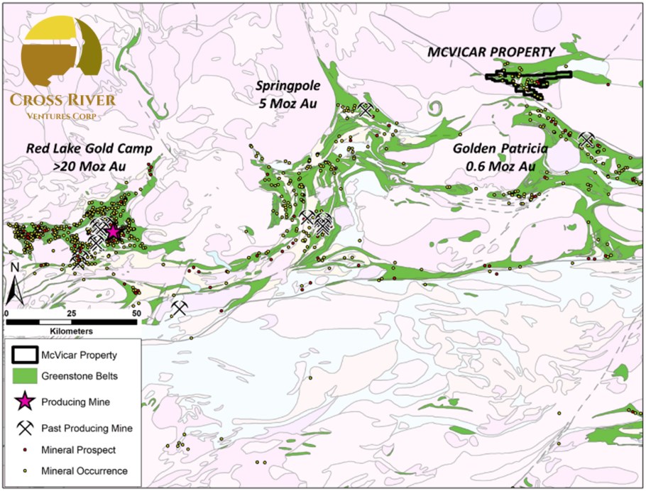
Image 1: Location of the 12,000-ha McVicar Gold Project, NW Ontario, Canada
To view an enhanced version of Image 1, please visit:
https://orders.newsfilecorp.com/files/7276/108298_29f8c4b124275bf2_002full.jpg
The winter drill program is fully funded, and the Company has received all relevant permits. This initial drill program will focus on two high-grade gold trends located at the Altered Zone and the newly discovered Bear Head Zone.
"A lot of prep work has gone into the project so far," said CEO, Alex Klenman. "Our tech team has spent countless hours going through historical data and generating new favourable data through airborne surveys, ground reconnaissance and sampling programs. The project is large and has multiple zones of interest that all make a compelling case for drill testing. This is an exciting first step for us and we're eager to begin the next phase of exploration at McVicar," continued Mr. Klenman.
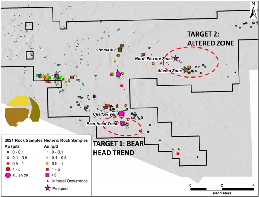
Image 2: Initial target zones, McVicar Gold Project
To view an enhanced version of Image 2, please visit:
https://orders.newsfilecorp.com/files/7276/108298_29f8c4b124275bf2_003full.jpg
The Winter 2022 drill program builds on the successful Phase 1 field campaign reported in the Company's New Release dated October 5, 2021. The Phase 1 field program confirmed the locations of historic bedrock gold occurrences. In addition, new outcropping gold mineralization was discovered.
Importantly, the 2021 field work identified and outlined a new mineralized trend structure south of the historic Chellow Vein, named the "Bear Head" Zone. The Bear Head Zone is characterized by an extensive NW-trending multi-kilometer damage zone in altered mafic volcanic rocks, coincident with braided lineaments and structural breaks identified in (topographic) Lidar features as well as magnetic datasets.

Image 3: Location of the new Bear Head Trend, 550m south of and parallel to the Chellow Vein
To view an enhanced version of Image 3, please visit:
https://orders.newsfilecorp.com/files/7276/108298_29f8c4b124275bf2_004full.jpg
Target One - The Bear Head Zone
The Bear Head is a newly discovered, undrilled, minimum 700-meter-long, high-grade gold corridor, nested within a multi-kilometer gold-bearing crustal-scale break. Two samples collected from sheared and silicified mafic metavolcanic rocks containing smoky-blue quartz veins (1-10 centimeter-wide), returned gold values of 19.75 grams-per-tonne ("g/t") gold ("Au") and 1.415 g/t Au, respectively (see Company news release dated October 5, 2021).
Field crews identified this new trend approximately 600 meters south of the historic Chellow Vein. The Bear Head Zone is situated near the southern contact between mafic metavolcanic rocks and granite outboard of the Bear Head Fault Zone.
The surface exposure of the shear zone shows up clearly as a discrete WNW trending break on the 2021 Lidar survey data. Magnetic data shows a coincident linear anomaly (high and magnetic edge feature).
The drill program will test the extent of the anomaly at depth across the recessive zone at and adjacent to the structural/magnetic breaks which are coincident with the mapped gold zones.
Target Two - The Altered Zone
Shallow historic drilling at the prospective Altered Zone target intercepted 6.46 g/t Au over 10.09m (including 33 g/t Au over 1.86m) (drillhole ML-86-27[1]), 5.7 g/t Au over 7.71m (drillhole ML-03-01[2]), amongst other high-grade results. Trenching of the shear zone approximately 200m north of the claims returned 6.89 g/t Au over 1.55m (trench AZ-03-05; Continuum Resources Ltd.[3]).
New geologic modelling by Cross River in 2021 utilizes historic drilling data and suggests that the high-grade gold bearing structure continues at depth, coincident with lithologic breaks and a broader damage zone corridor characterized by an intense hydrothermal alteration overprint. The gold bearing structure at the Altered Zone is open in all directions (strike and depth). The upcoming drill program is designed to test the gold grade and continuity along strike, down-dip and down-plunge and will also test for new gold shoots and domains at several locations along the broader Altered Zone structural trend.
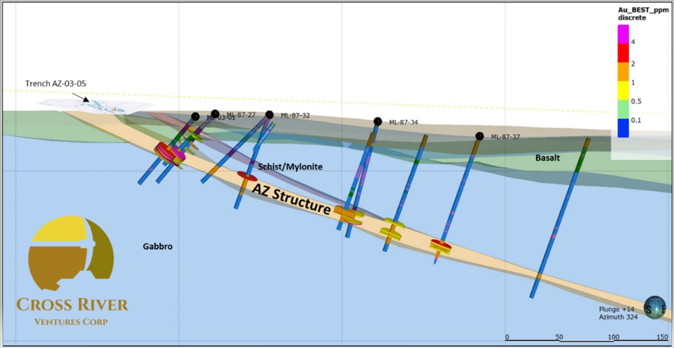
Image 4: Cross section view of the Altered Zone with historic drilling. The AZ Structure is inferred target containing high-grade intercepts from previous drilling.
To view an enhanced version of Image 4, please visit:
https://orders.newsfilecorp.com/files/7276/108298_29f8c4b124275bf2_005full.jpg
The Company received Early Exploration Permits for the McVicar property in June 2021. These permits allow Cross River to advance the property through diamond drilling in the Altered Zone and along the Bear Head Gold Trend. However, an unusual fire season inhibited field work at McVicar until late in the year.
The upcoming Q1 helicopter-supported program will stage from the Cat Lake Winter Road. The window for the winter road will dictate the exact timing of the 2022 5000m drilling campaign.
About the McVicar Project
Cross River's McVicar Gold Project is a district-scale gold exploration project that covers the main structural elements of the entire Lang Lake greenstone belt located in the Patricia Mining Division, approximately 150 km east of Red Lake, and 80 km west of Pickle Lake, in NW Ontario, Canada.
The McVicar project covers all the major fertile structural and lithostratigraphic elements of the greenstone belt, which is bound to the south by the major NW trending Bear Head Fault zone (within which the historic Golden Patricia Mine is situated).
Historic drilling at McVicar Lake in the Altered and North Flexure Zones include[4]:
- 6.46 g/t Au over 10.09 m including 29.86 g/t Au over 1.86 m
- 5.5 g/t Au over 3.6 m including 12.2 g/t Au over 0.98m
The McVicar Lake claims also host the Chellow Vein zone, which is a narrow quartz vein that consists of smoky grey to white quartz mineralized with minor pyrite and visible gold. The vein system yielded high grade gold at surface including grab samples^ that yielded 827.4 g/t Au and 578.1 g/t Au[5].
Limited drill testing below the known showings in the early 1990's didn't yield significant gold assay values; however, the Cross River technical team believe the Chellow Vein is hosted in a much broader (1-2km wide) high-strain deformation corridor, characterized by a series of parallel-trending shears that have not been systematically tested.
^ Grab samples are selective by nature and may not represent the true grade or style of mineralization across the property.
Dr. Rob Carpenter, P.Geo., Ph.D., a Qualified Person as defined under National Instrument 43-101, reviewed, and approved the technical content disclosed in this press release. Historical assay results contained in this press release were not verified by the Company. However, the historical reports referenced were authored by experienced geoscientists and copies of laboratory assay sheets were commonly inserted in the reports.
About Cross River Ventures
Cross River is a gold exploration company focused on the development of top tier exploration properties located in emerging Greenstone Districts of NW Ontario, Canada. The Company controls a 28,000-ha, multiple project portfolio with highly prospective ground in and among prolific, gold bearing greenstone belts. Cross River's common shares trade in Canada under the symbol "CRVC" on the CSE, and in the US under the symbol "CSRVF" on the OTCQB. Please visit www.crossriverventures.com for more information.
On behalf of the Board of Directors of
CROSS RIVER VENTURES CORP.
Alex Klenman
CEO
604-227-6610
aklenman@crossriverventures.com
www.crossriverventures.com
Neither the Canadian Securities Exchange nor its Regulation Services Provider (as that term is defined in the policies of the Canadian Securities Exchange) accepts responsibility for the adequacy or accuracy of this release.
This news release may contain forward-looking statements. These statements are based on current expectations and assumptions that are subject to risks and uncertainties. Actual results could differ materially because of factors discussed in the management discussion and analysis section of our interim and most recent annual financial statement or other reports and filings with the Canadian Securities Exchange and applicable Canadian securities regulations. We do not assume any obligation to update any forward-looking statements, except as required by applicable laws.
[1]McKay D.B. Diamond Drill Log - McVicar Lake: Continuum Resources Ltd. http://www.geologyontario.mndm.gov.on.ca/mndmfiles/afri/data/imaging/52O11SW2004/52O11SW2004.pdf
Ibid.
[2]McKay D.B. Diamond Drill Log - McVicar Lake: Continuum Resources Ltd. http://www.geologyontario.mndm.gov.on.ca/mndmfiles/afri/data/imaging/52O11SW2004/52O11SW2004.pdf
[4] McKay D.B, 2004. Report on the 2003 Overburden Stripping, Geologic Mapping and Sampling Program conducted on the McVicar Lake Property: Continuum Resources Ltd and Prospector Consolidated Resources Inc.
www.geologyontario.mndm.gov.on.ca/mndmfiles/afri/data/imaging/52O11SW2003/52O11SW2003.pdf
[5] Waldie C.J. Report of Diamond Drilling McVicar Lake Area Patricia Mining Division: BHP Minerals Canada Ltd. http://www.geologyontario.mndm.gov.on.ca/mndmfiles/afri/data/imaging/52O11SW0014/52O11SW0014.pdf
![]()
To view the source version of this press release, please visit https://www.newsfilecorp.com/release/108298
Source: Cross River Ventures Corp.