Assays confirm copper grades up to 18.48% over 13.6 metres in the new discovery area
Four rigs drilling at Kamoa North to delineate the extent of the discovery and assess its potential to be fast-tracked to production to increase Kamoa-Kakula's early copper grades
East-west-striking fault structure associated with the Kamoa North Bonanza Zone can be traced for up to 20 kilometres onto the adjacent Western Foreland exploration licences that are 100%-owned by Ivanhoe Mines
Drilling extends the nine-kilometre corridor of shallow, high-grade copper at the Kamoa Far North discovery to the boundary of Ivanhoe's Western Foreland licences
Kolwezi, Democratic Republic of Congo--(Newsfile Corp. - May 2, 2019) - Robert Friedland and Yufeng "Miles" Sun, Co-Chairmen of Ivanhoe Mines (TSX: IVN) (OTCQX: IVPAF), announced today that the strike length of the shallow, thick, massive copper sulphide mineralization at Kamoa North that was discovered earlier this year in drill hole DD1450 on the Kamoa-Kakula mining licence in the Democratic Republic of Congo (DRC) − 13.05% copper over 22.3 metres (true thickness), at a 2% copper cut-off grade − has been significantly extended by assays received from ongoing drilling.
Recent drilling has confirmed that the discovery zone of bonanza-grade copper mineralization at Kamoa North ─ the Kamoa North Bonanza Zone ─ is continuous over a strike length of at least 350 metres and a width of up to 60 metres. The mineralized zone has a drilled thickness of between six and 30 metres, and is approximately 170 to 220 metres below surface, with grades ranging as high as 18.48% copper over 13.6 metres, at both a 2% and a 3% cut-off grade.
The Kamoa North Bonanza Zone represents a new style of copper mineralization at Kamoa-Kakula, where massive to semi-massive chalcopyrite, bornite and chalcocite have locally replaced pyrite in the Kamoa Pyritic Siltstone (KPS) - a pyritic siltstone that lies immediately above the basal diamictite unit that typically hosts the copper mineralization at Kamoa-Kakula.
Assay results for 10 new holes have been received from the Kamoa North drilling (see Table 1 on page 15 for a complete list of assays).
Significant new drilling intercepts at the Kamoa North Bonanza Zone include:
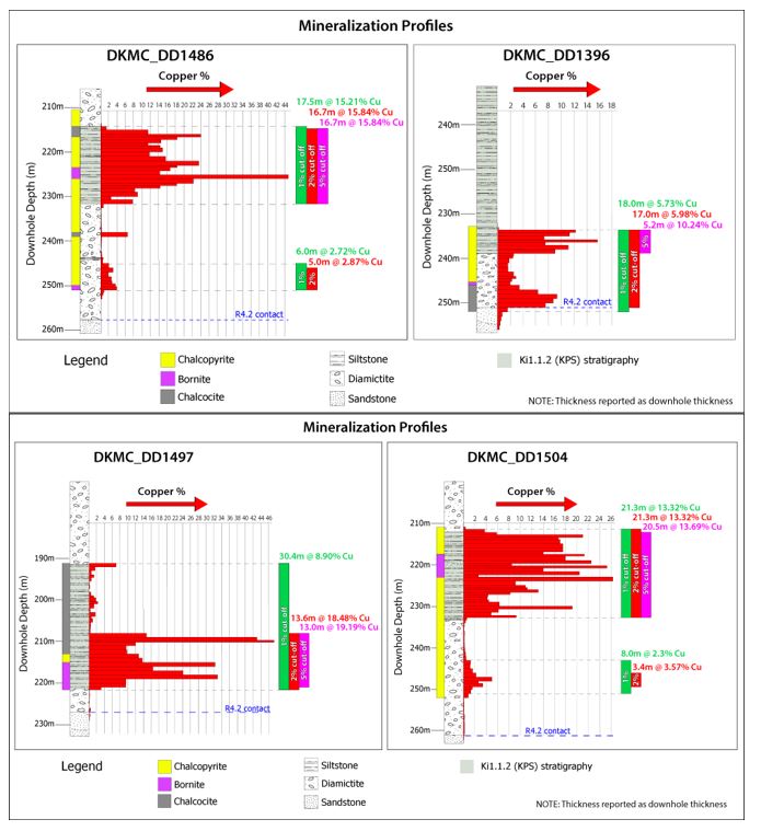
- DD1486 intersected 16.70 metres of 15.84% copper, at a 3% and 2% copper cut-off, in semi-massive sulphide KPS-hosted mineralization, beginning at a downhole depth of 215 metres; and 17.46 metres of 15.21% copper at a 1% cut-off.
- DD1494 intersected 13.15 metres of 9.88% copper, at a 3%, 2% and 1% copper cut-off, in semi-massive sulphide KPS-hosted mineralization, beginning at a downhole depth of 215.50 metres.
- DD1497 intersected 13.60 metres of 18.48% copper, at a 3% and 2% copper cut-off, in semi-massive sulphide KPS-hosted mineralization, beginning at a downhole depth of 208.00 metres; and 30.37 metres of 8.90% copper at a 1% cut-off.
- DD1498 intersected 16.48 metres of 10.94% copper, at a 3% and 2% copper cut-off, in semi-massive sulphide KPS-hosted mineralization, beginning at a downhole depth of 222 metres; and 16.48 metres of 10.94% copper at a 1% cut-off.
- DD1499 intersected 16.93 metres of 11.31% copper, at a 3% copper cut-off, and 17.35 metres of 11.10% copper, at a 2% copper cut-off, in semi-massive sulphide KPS-hosted mineralization, beginning at a downhole depth of 205 metres; and 18.35 metres of 10.57% copper at a 1% cut-off.
- DD1504 intersected 21.25 metres of 13.32% copper, at a 3%, 2% and 1% copper cut-off, in semi-massive sulphide KPS-hosted mineralization, beginning at a downhole depth of 211.15 metres.
"After more than 10 years of exploration on the 400-square-kilometre Kamoa-Kakula licence area, it is highly encouraging that we still are making new discoveries of thick zones of massive sulphide with copper grades in excess of 18%," said Dr. David Broughton, Ivanhoe's Senior Advisor, Exploration and Geology.
"The grades and thicknesses encountered at shallow depths at the new Kamoa North discovery are truly exceptional. These results underscore the world-class status of the Kamoa-Kakula Project, as well as the outstanding potential for major new copper discoveries on our adjoining 100%-owned Western Foreland exploration licences."
Discovery of the new style of KPS-hosted mineralization at Kamoa North opens the door to multiple exploration opportunities at Kamoa-Kakula and the adjoining Western Foreland ground
The ultra-high copper grades intercepted to date in the Kamoa North Bonanza Zone are believed to be the result of the controlling east-west growth fault structure having allowed oxidized, copper-rich brines to bypass the lower redox interface at the Roan-Nguba contact that is the typical mineralized horizon at Kamoa-Kakula. Instead, the copper-rich brines accessed the overlying, highly-sulphidic and reduced KPS, resulting in a new, upper mineralized zone hosted in the KPS and characterized by the bonanza-grade copper found in the vicinity of hole DD1450.
The growth fault structure is characterized by a wide zone of sub-parallel, low-angle, fault planes dipping at approximately 40 degrees to the south through the KPS (see Figure 4). Replacement of pyrite in the vicinity of these fault planes, as a result of a combination of cross-stratal and stratabound fluid flow, has created a 50-to 60-metre-wide zone of mineralization that transects the KPS from top in the north to bottom in the south.
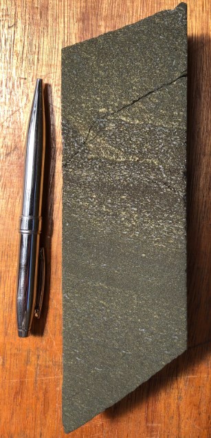
Pyrite is an excellent reductant, and consequently in many places the pyrite has been completely replaced by chalcopyrite, bornite and chalcocite (see figures 7, 8 and 9). The copper content of chalcopyrite is approximately 35%, while the copper content of bornite is approximately 63% and is nearly 80% for chalcocite.
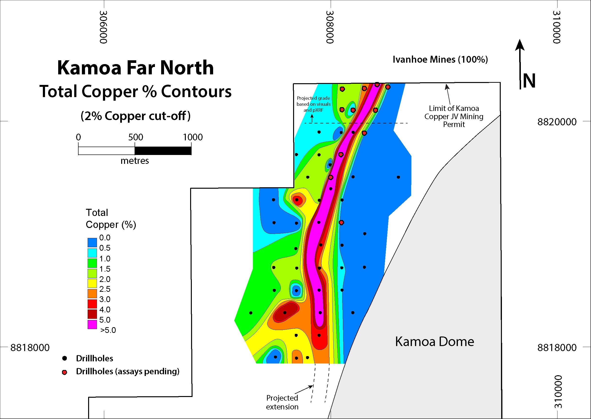
The Kamoa North Bonanza Zone remains open along a westerly-easterly strike for a considerable distance. An east-west lineament, thought to represent the controlling growth structure, can be traced in aeromagnetic data for up to 20 kilometres, across the western side of the Kamoa-Kakula Mining Licence and onto Ivanhoe's adjoining, 100%-owned Western Foreland exploration licences (see Figure 2).
The controlling east-west structure was previously intersected in holes DD0015, DD1200 and DD1396 that were drilled as part of an earlier, wide-spaced resource delineation drilling program. The recent, detailed drilling in the hole DD1450 discovery area has led Kamoa geologists to consider that these earlier holes may have intercepted the same structure that hosts the KPS bonanza-grade copper, inferring a corridor of high-grade copper of at least 2.7 kilometres. See Figure 2 for the location of holes DD0015, DD1200 and DD1396, and Table 1 for the composite assays.
"The recognition of this new, structurally-controlled KPS-hosted copper mineralization has opened up multiple new, high-priority exploration targets at Kamoa-Kakula and on Ivanhoe's Western Foreland licences," said David Edwards, Geology Manager for the Kamoa-Kakula Project.
Three additional drill rigs have been added at Kamoa North, bringing the total to four, to accelerate testing along the strike of the east-west trending structure. Twenty-one drill holes now have been completed along the mineralized trend and assays are pending for 11 recent holes.
Kamoa North rapidly emerging as a prospective, ultra-high-grade resource area with the potential to be fast-tracked to development and increase Kamoa-Kakula's early copper grades
Given the shallow depth, remarkable thickness and massive copper sulphide mineralization discovered within the Kamoa North Bonanza Zone, Kamoa-Kakula's engineers are evaluating potential options to accelerate the development of this new discovery. Based on the shallow depth of the high-grade mineralized intercepts to date, the discovery zone may be accessed by way of a surface box-cut and decline, similar to those at the Kakula and Kansoko deposits, in a relatively short time-frame.
Any material mined at Kamoa North could be processed at a nearby, standalone plant, or hauled to the plant that will be constructed at Kakula. This has the potential of significantly increasing the copper grades during the initial stages of production at Kamoa-Kakula.
"Kamoa North is a unique opportunity to potentially enhance the project's initial cash flows," said Mr. Friedland. "Our objective now is to move quickly to an initial resource estimate, providing the basis for our engineers to assess the impact that early mining and processing of the bonanza-grade material will have on the project's economics."
The Kamoa North discovery is on the Kamoa-Kakula mining licence, approximately 18 kilometres north of the project's planned initial mine and milling facility at the Kakula Deposit and approximately eight kilometres north of another planned mine − Kansoko − at the Kamoa Deposit.
Drilling also is continuing at the Kamoa Far North discovery, located north of the Kamoa North Bonanza Zone, near the northern border of Kamoa-Kakula mining licence. Exploration in this area is targeting a "typical" Kamoa-Kakula mineralized horizon, which follows a north-south-trending corridor of high-grade copper (see Figure 1). Drilling to date has extended the corridor of shallow, high-grade copper mineralization at the Kamoa Far North discovery to the northern border of the Kamoa-Kakula mining licence and within 15 metres of Ivanhoe's 100%-owned Western Foreland exploration licences.
Figure 1: Kamoa-Kakula mining licence, showing the Kamoa North Area, the Kamoa Far North Area, the planned mines at Kakula and Kansoko, and part of the 100%-owned Western Foreland exploration licences.

To view an enhanced version of Figure 1, please visit:
https://orders.newsfilecorp.com/files/3396/44499_2f753850946f48b0_002full.jpg
Figure 2: Location plan map of the Kamoa North Bonanza Zone (drill intercepts shown at a 2% copper cut-off).

To view an enhanced version of Figure 2, please visit:
https://orders.newsfilecorp.com/files/3396/44499_2f753850946f48b0_003full.jpg
The Kamoa-Kakula Project is approximately 25 kilometres west of the mining centre of Kolwezi in the DRC. It is a joint venture between Ivanhoe Mines (39.6%), Zijin Mining Group (39.6%), Crystal River Global Limited (0.8%) and the DRC government (20%). Ivanhoe Mines and Zijin Mining are co-funding development of the Kamoa-Kakula Copper Project.
Based on existing mineral resources, Kamoa-Kakula has been independently ranked as the world's fourth-largest copper deposit and Kamoa-Kakula's copper grades are the highest, by a wide margin, of the world's top 10 copper deposits.
Kamoa-Kakula is unique as it combines ultra-high copper grades in thick, shallow and relatively flat-lying deposits ─ allowing for large-scale, highly-productive, mechanized underground mining operations. Kakula, the first of multiple planned mines expected to be placed into production at Kamoa-Kakula, is projected to have an average grade of 6.8% copper over the initial five years of operations, and 6.4% copper over the first 10 years ─ grades that are orders of magnitude higher than the majority of the world's other major copper mines.
Figure 3: Plan view of Kamoa North Bonanza Zone drill-hole collars and interpreted high-grade corridor (drill intercepts shown at a 2% copper cut-off).

To view an enhanced version of this graphic, please visit:
https://orders.newsfilecorp.com/files/3396/44499_2f753850946f48b0_004full.jpg
Drill intersections for the holes in this release are reported as drilled thicknesses pending more detailed drilling and analysis; however, preliminary interpretation of drill sections indicates that the majority of drill holes transected the zone at approximately perpendicular angles (see Figure 4 below for an illustration).
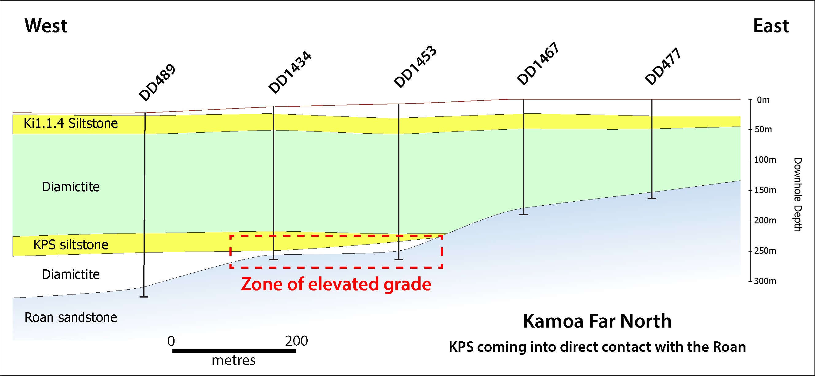
Figure 4 shows the diamictite layer (in white) that is the typical mineralized horizon at Kamoa and Kakula, as well as the overlying KPS siltstone layer (in yellow) that hosts the Kamoa North Bonanza Zone mineralization.
Figure 4: Section view through the Kamoa North Bonanza Zone.

To view an enhanced version of Figure 4, please visit:
https://orders.newsfilecorp.com/files/3396/44499_2f753850946f48b0_005full.jpg
Figure 5: Copper grade profiles of recent holes across Kamoa North Bonanza Zone showing dominant copper sulphide, copper assay values and composite grades at 1%, 2% and 5% copper cut-offs.
To view an enhanced version of Figure 5, please visit:
https://orders.newsfilecorp.com/files/3396/44499_figure5_enhanced.jpg
Figure 6: Comparative copper grade profiles from Kansoko, Kakula and Kamoa North discoveries.

To view an enhanced version of Figure 6, please visit:
https://orders.newsfilecorp.com/files/3396/44499_2f753850946f48b0_010full.jpg
Figure 7: Examples of mineralization from the Kamoa North Bonanza Zone.

To view an enhanced version of Figure 7, please visit:
https://orders.newsfilecorp.com/files/3396/44499_figure7_enhanced.jpg
Figure 8: Very strong bornite mineralization in siltstone from a new Kamoa North hole, DD1522, at a depth of approximately 201.8 metres. Assays are pending for this high-grade hole, which currently is defining the eastern limit of the 350-metre drill tested zone.

To view an enhanced version of Figure 8, please visit:
https://orders.newsfilecorp.com/files/3396/44499_2f753850946f48b0_020full.jpg
Figure 9: Very strong chalcopyrite mineralization in siltstone from a depth of 221.8 metres in new hole DD1524. Assays are pending for this high-grade hole, which currently is defining the western limit of the 350-metre drill tested zone.
To view an enhanced version of Figure 9, please visit:
https://orders.newsfilecorp.com/files/3396/44499_2f753850946f48b0_021full.jpg
Drilling extends the nine-kilometre corridor of shallow, high-grade copper at the Kamoa Far North discovery to the boundary of Ivanhoe's 100%-owned Western Foreland exploration licences
Kamoa-Kakula geologists also are exploring another zone of shallow, high-grade copper mineralization in the far northern region of the Kamoa-Kakula mining licence.
The Far North exploration target is the more typical stratiform mineralization characteristic of the majority of the Kamoa-Kakula copper deposits. The high-grade zone follows a north-south trend controlled by growth faulting and by the pinching out of the basal diamictite and the KPS against the Roan sandstone on the western flank of the Kamoa Dome. The pinching out results in the sulphide-rich upper portion of the diamictite and the KPS being brought into direct contact with the Roan Aquifer, resulting in the high copper grades seen at Kamoa Far North (see Figure 11 for an illustration). The resulting mineralized corridor trends for more than nine kilometres and is projected to continue onto the adjacent Western Foreland exploration licences.
The Kamoa Geology team has been drill testing the high-grade trend to the north of Kamoa North and has successfully followed it to within 15 metres of the northern boundary of the Kamoa-Kakula mining licence. Assays from 11 holes currently are pending from drilling in this area. The outline of the mineralized zone delineated to date at the Kamoa Far North exploration area is shown in Figure 10 below.
Figure 10: Kamoa Far North exploration target, showing the high-grade mineralized zone delineated to date.
To view an enhanced version of Figure 10, please visit:
https://orders.newsfilecorp.com/files/3396/44499_2f753850946f48b0_022full.jpg
Figure 11: Illustration of Kamoa Far North discovery area, showing how the basal diamictite and the KPS siltstone pinch out against the Roan sandstone on the western flank of the Kamoa Dome, creating a zone of elevated copper grades.
To view an enhanced version of Figure 11, please visit:
https://orders.newsfilecorp.com/files/3396/44499_2f753850946f48b0_023full.jpg
Table 1: Summary of composites for all Kamoa North holes with assays received.

To view an enhanced version of Table 1, please visit:
https://orders.newsfilecorp.com/files/3396/44499_2f753850946f48b0_024full.jpg
Drill intersections are reported as drilled thicknesses pending more detailed analysis. Preliminary interpretation of drill sections (see Figure 4) indicates that the majority of drill holes transected the zone at approximately perpendicular angles to the interpreted dip of the mineralized zone.
Table 2: Collars of drill holes discussed in this release.

To view an enhanced version of Table 2 please visit:
https://orders.newsfilecorp.com/files/3396/44499_2f753850946f48b0_025full.jpg
*All collars surveyed by differential GPS except DKMC_DD1522.
Qualified Person and Quality Control and Assurance
Scientific and technical information in this news release has been reviewed and approved by Stephen Torr, P.Geo., Ivanhoe Mines' Vice President, Project Geology and Evaluation, a Qualified Person under the terms of National Instrument 43-101. Mr. Torr is not independent of Ivanhoe Mines. Mr. Torr has verified the technical data disclosed in this news release.
Ivanhoe Mines maintains a comprehensive chain of custody and quality assurance and quality control (QA/QC) program on assays from its Kamoa-Kakula Project. Half-sawn core is processed at the Kamoa-Kakula on-site preparation laboratory and prepared samples then are shipped by secure courier to Bureau Veritas Minerals (BVM) Laboratories in Australia, an ISO17025-accredited facility. Copper assays are determined at BVM by mixed-acid digestion with ICP finish. Industry-standard certified reference materials and blanks are inserted into the sample stream prior to dispatch to BVM. For detailed information about assay methods and data verification measures used to support the scientific and technical information, please refer to the March 2019 technical report titled "Kamoa-Kakula 2019 Integrated Development Plan", on the Ivanhoe Mines SEDAR profile at www.sedar.com and available at www.ivanhoemines.com.
About Ivanhoe Mines
Ivanhoe Mines is a Canadian mining company focused on advancing its three principal projects in Southern Africa: the development of new mines at the Kamoa-Kakula copper discovery in the Democratic Republic of Congo (DRC) and the Platreef palladium-platinum-nickel-copper-gold discovery in South Africa; and the extensive redevelopment and upgrading of the historic Kipushi zinc-copper-germanium-silver mine, also in the DRC. The company also is exploring for new copper discoveries on its wholly-owned Western Foreland exploration licences, adjacent to the Kamoa-Kakula mining licence.
Information contacts
Investors: Bill Trenaman +1.604.331.9834
Media: Kimberly Lim +1.778.996.8510
Cautionary statement on forward-looking information
Certain statements in this release constitute "forward-looking statements" or "forward-looking information" within the meaning of applicable securities laws, including without limitation, (1) statements regarding that Kamoa North Bonanza Zone has an implied strike length of at least 2.7 kilometres; (2) statements regarding Kamoa-Kakula's engineers are evaluating potential options to accelerate the development of the Kamoa North Bonanza Zone; (3) statements regarding the Kamoa North discovery zone may be accessed by way of a surface box-cut and decline, similar to those at the Kakula and Kansoko deposits, in a relatively short time-frame; (4) statements regarding any material mined at Kamoa North could be processed at a nearby, standalone plant, or hauled to the plant that will be constructed at Kakula and that this has the potential of significantly increasing the copper grades during the initial stages of production at Kamoa-Kakula.
Such statements involve known and unknown risks, uncertainties and other factors which may cause the actual results, performance or achievements of the company, or industry results, to be materially different from any future results, performance or achievements expressed or implied by such forward-looking statements or information. Such statements can be identified by the use of words such as "may", "would", "could", "will", "intend", "expect", "believe", "plan", "anticipate", "estimate", "scheduled", "forecast", "predict" and other similar terminology, or state that certain actions, events or results "may", "could", "would", "might" or "will" be taken, occur or be achieved. These statements reflect the company's current expectations regarding future events, performance and results and speak only as of the date of this release.
All such forward-looking information and statements are based on certain assumptions and analyses made by Ivanhoe Mines' management in light of their experience and perception of historical trends, current conditions and expected future developments, as well as other factors management believe are appropriate in the circumstances. These statements, however, are subject to a variety of risks and uncertainties and other factors that could cause actual events or results to differ materially from those projected in the forward-looking information or statements including, but not limited to, unexpected changes in laws, rules or regulations (including retroactive application), the failure of contractual agreements with the State to be honoured in whole or in part, or in the enforcement or application of laws, rules and regulations by applicable authorities; the failure of parties to contracts to perform as agreed; social or labour unrest; changes in commodity prices, including the price of copper; unexpected failure or inadequacy of infrastructure, or delays in the development of infrastructure, the failure of exploration programs or other studies to deliver anticipated results or results that would justify and support continued studies, development or operations, and the results of economic studies and evaluations. Other important factors that could cause actual results to differ from these forward-looking statements also include those described under the heading "Risk Factors" in the company's most recently filed MD&A as well as in the most recent Annual Information Form filed by Ivanhoe Mines. Readers are cautioned not to place undue reliance on forward-looking information or statements. The factors and assumptions used to develop the forward-looking information and statements, and the risks that could cause the actual results to differ materially are set forth in the "Risk Factors" section and elsewhere in the company's most recent Management's Discussion and Analysis report and Annual Information Form, available at www.sedar.com.
This news release also may contain references to estimates of Mineral Resources. The estimation of Mineral Resources is inherently uncertain and involves subjective judgments about many relevant factors. Mineral Resources that are not Mineral Reserves do not have demonstrated economic viability. The accuracy of any such estimates is a function of the quantity and quality of available data, and of the assumptions made and judgments used in engineering and geological interpretation, which may prove to be unreliable and depend, to a certain extent, upon the analysis of drilling results and statistical inferences that may ultimately prove to be inaccurate.
Mineral Resource estimates may have to be re-estimated based on, among other things: (i) fluctuations in copper prices or other mineral prices; (ii) results of drilling; (iii) results of metallurgical testing and other studies; (iv) changes to proposed mining operations, including dilution; (v) the evaluation of mine plans subsequent to the date of any estimates; (vi) the possible failure to receive required permits, approvals and licences, or changes to any such permits, approvals or licences; and (v) changes in laws, rules or regulations, including changes to tax, VAT, and royalty rates whether to be applied prospectively or retroactively.
Although the forward-looking statements contained in this news release are based upon what management of the company believes are reasonable assumptions, the company cannot assure investors that actual results will be consistent with these forward-looking statements. These forward-looking statements are made as of the date of this news release and are expressly qualified in their entirety by this cautionary statement. Subject to applicable securities laws, the company does not assume any obligation to update or revise the forward-looking statements contained herein to reflect events or circumstances occurring after the date of this news release.
To view the source version of this press release, please visit https://www.newsfilecorp.com/release/44499
Source: Ivanhoe Mines Ltd.