Vancouver, British Columbia--(Newsfile Corp. - October 22, 2025) - Golden Spike Resources Corp. (CSE: GLDS) (OTCQB: GSPRF) (FSE: L5Y) ("Golden Spike" or the "Company") is pleased to announce the drill results from the recently completed Winkie drilling on its 100%-owned Gregory River Copper-Gold Property ("the Property"), located in western Newfoundland.
Selected highlights from the drill hole analytical results include:
Lower Mitchell Target
- 0.68 grams per tonne ("g/t") gold equivalent* ("AuEq") over 29.45 m (hole WD25-08, 13.2 m to 42.65 m)
– Including, 1.02 g/t AuEq over 11.65 m (31.0 m to 42.65 m)
– Including, 1.76 g/t AuEq over 3.0 m (31.0 m to 34.0 m)
– Including, 5.46 g/t AuEq over 0.5 m (31.0 m to 31.5 m)
- 0.30 g/t AuEq over 53.4 m (hole WD25-05, 9.5 m to 62.9 m)
– Including, 1.48 g/t AuEq over 0.5 m (38.2 m to 38.7 m)
– and 0.65 g/t AuEq over 11.4 m (47.1 m to 58.5 m)
- 0.40 g/t AuEq over 5.3 m (hole WD25-03, 8.2 m to 13.5 m)
– Including, 0.86 g/t AuEq over 1.5 m (12.0 m to 13.5 m
*AuEq is defined below Table 1
A complete summary of the significant drill hole results is provided in Tables 1 and 2.
Golden Spike CEO, Keith Anderson, commented, "We are very pleased with the Winkie drill results, which certainly exceeded our expectations. The drilling not only resulted in several significant gold, copper and zinc intercepts, but across much wider intervals than the previous surface work indicated. The true overall dimensions and potential grades of this early-stage prospect remain to be determined, and our technical team will be reviewing these results in more detail and planning additional work, including diamond drilling. As we have stated on numerous occasions, we believe that the Gregory River property holds strong exploration potential for several styles of copper, gold and zinc mineralization, and we are still in the early days of discovery."
Winkie Drilling Results
The Winkie drilling program included eight, shallow drill holes, totalling approximately 423.7 m that tested several high-priority, ATV trail-accessible targets. The Winkie drill is a mobile diamond drill rig designed as a prospecting tool to test near-surface prospects and anomalies and is capable of drilling to lengths of about 50-70 m. If warranted, significant results can be followed up with a larger rig capable of deeper holes and larger diameter core. Three areas were drilled during the program, Lode 9 Northeast, Lower Mitchell and the Western Vein Zone (Figure 1). The most significant drill results of this program were returned from the Lower Mitchell Target.
Lower Mitchell
Drill holes WD25-03, 04, 04, 07 and 08 tested the Lower Mitchell Target (Figure 2), where an east to east-northeast trending breccia-stockwork copper-gold+/-zinc prospect is exposed on surface. The host basaltic rocks are mostly weathered and gossanous, however brecciation textures and pervasive chlorite-carbonate alteration, along with local silicification is evident. The rocks are cut by multiple quartz-carbonate veins with many of the veins and breccia-infill mineralized with limonite and occasional unweathered sulphides, including pyrite, chalcopyrite, sphalerite and arsenopyrite. The target is only exposed in two small outcrops (maximum 2-5 m wide), spaced 15 m apart, within a large 90 m by 30 m clearing, which is devoid of vegetation and mostly covered with subcrop rubble (the Western Showing). A second clearing and a mineralized outcrop occur approximately 100 m to the southeast (the Eastern Showing).
The target was first discovered during the 1950's when Cape Copper Mines reportedly completed overburden stripping and drove a short exploration adit below the Eastern Showing, however there is no documentation of the results, and the adit entrance is no longer exposed. Several companies subsequently completed small programs of surface prospecting, including RioCanex (Rio Tinto) during the 1980's and Noranda during the early 1990's. Noranda completed soil sampling, which was analysed for copper and zinc resulting in anomalies of 190 ppm to 1,140 ppm copper and 188 ppm to 1,916 ppm zinc, which are coincident with the Western Showing and additional copper (80 ppm to 286 ppm) and zinc (110 ppm to 392 ppm) soil anomalies approximately 250 m to the west southwest, providing some evidence of potential strike extension of the prospect. Since the companies that collected the historical surface rock and soil samples were large, reputable companies that would have had sampling methodologies and quality control processes in place that were considered industry-standard for that time, the QP feels that it is reasonable to report these results as historical and to use them as a guide for on-going exploration at these prospects.
Golden Spike sampled the area in 2022 collecting several grab and float samples, along with two channel sample lines across the two outcrops. Many of the grab and float samples returned anomalous copper, gold and zinc values, along with arsenic anomalies in the range of 0.07 to 2.45% copper, 0.05 to 1.53 g/t gold and trace to 0.41% zinc (refer to press release dated December 21, 2022, "Golden Spike Announces Reconnaissance Sampling Results"). The two channel chip sample lines returned 0.08% copper, 0.24 g/t gold and 0.22% zinc over 2 m, and 2.73% copper, 0.14 g/t gold and 0.34% zinc over 5 m, including 12.9% copper, 0.23 g/t gold, 11.5 g/t silver and 0.27% zinc over 1 m.
Based on the historical and previous Golden Spike work, the Lower Mitchell prospect was previously interpreted to be in the range of 2 to 5 m wide, with an unknown depth or strike length potential. The Winkie drilling was designed to test below these mineralized outcrops and determine the width and grade potential of the target.
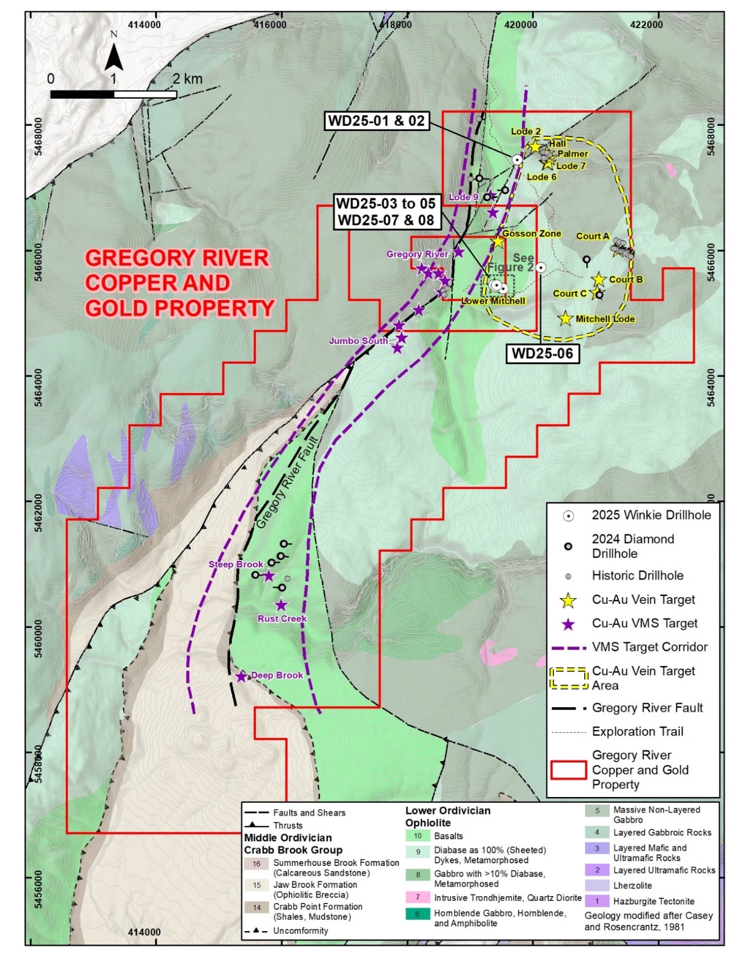
Figure 1 - Location of Winkie Drill Holes
To view an enhanced version of this graphic, please visit:
https://images.newsfilecorp.com/files/8310/271382_ea038a87d43b7822_001full.jpg
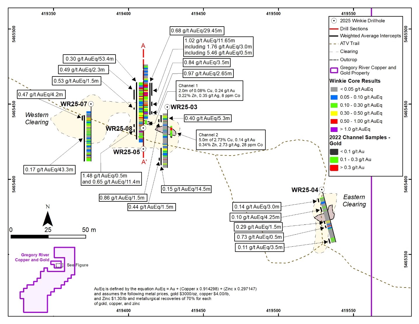
Figure 2 - Lower Mitchell Target - Plan View of Winkie Drill Holes
To view an enhanced version of this graphic, please visit:
https://images.newsfilecorp.com/files/8310/271382_ea038a87d43b7822_002full.jpg
A total of five holes were drilled at Lower Mitchell, four (WD25-03, 05, 07, 08) at the Western Clearing and one (WD25-04) at the Eastern Clearing (Figure 2). All drill holes intersected variably brecciated, and chlorite-carbonate altered basalt with zones of strong silicification. The rocks are cut by a series of quartz-carbonate veins and stockworks of varying intensity, mineralized with trace-40% sulphides, including pyrite, chalcopyrite, sphalerite and arsenopyrite. Drill holes WD25-05 and 08 were both drilled towards the north at -45 degrees on a north-oriented drill fence, returning significant assay results as shown below, on Table 1 and on Figure 3. The strongest mineralization occurs in an interpreted steeply dipping zone that returned:
WD25-05: 0.45 g/t gold, 0.09% copper, 0.42% Zn (0.65 g/t AuEq) over 11.4 m (47.1 m to 58.5 m)
WD25-08: 0.62 g/t gold, 0.33% copper, 0.35% Zn (1.02 g/t AuEq) over 11.65 m (31.0 m to 42.65 m)
Arsenic values are anomalous through the drill holes at Lower Mitchell, with grades within the mineralized intervals generally averaging between 100 and 500 ppm. Within the overall drill hole assay database there are 17 additional assay intervals with arsenic values exceeding the upper limit of the ICP analytical technique used by the laboratory (>1,000 ppm).
Drill holes WD25-03, 04 and 07, were collared on sections approximately 14 m east, 120 m east, and 36 m west, of holes WD25-05 and 08, respectively and all were drilled towards the south at -45 degrees. Each of these holes intersected similar variably altered and brecciated basalt, with varying amounts of breccia and veinlet hosted sulphides, but with less significant gold, copper and zinc anomalies (Table 1).
Early interpretations suggest that the Eastern Showing may be on a separate, subparallel trend to the Western showing, however additional work will be required to better establish the geometry of the mineralization.
Lode 9 Northeast
The first two drill holes of the program, WD25-01 and 02 were both drilled to investigate an induced polarization/resistivity ("IP") anomaly in the northeast corner of the Lode 9 volcanogenic massive sulphide ("VMS") target (refer to press release "Golden Spike Announces IP Survey Results from Gregory River, October 17, 2024) that is coincident with historical copper and zinc soil anomalies collected by Noranda in 1991. Both holes were collared at the same location, but drilled on a fence in opposite directions, to the east and west, respectively. Both holes crossed intervals of carbonate-chlorite altered massive basalt flows mixed with hyaloclastic breccias. Mineralization occurs as trace to 30% sulphides as stringers and disseminated pyrite and chalcopyrite +/- sphalerite, and a few local zones of semi-massive sulphides.
The significant intervals from the two holes at Lode 9 Northeast are summarized in Table 2 and below:
– 0.54% copper, 0.10 g/t gold and 0.08% zinc over 2 m (WD25-01, 7 to 9 m)
– 1.06% copper, 0.04 g/t gold and 0.05% zinc over 0.6 m (WD25-01, 33.35 to 33.85 m)
– 0.56% copper, 0.21 g/t gold and 0.02% zinc over 0.75 m (WD25-02, 34.95 to 35.7 m)
The intersections from holes WD25-01 and 02 are significant since they validate the IP anomaly and ground truth the historical copper soil anomalies that resulted from the 1991 Noranda survey. More importantly, they reveal a new zone of stratabound and/or stockwork copper (+/- gold) mineralization approximately 750 m to the northeast of the main Lode 9 zone that was drilled during 2024.
West Vein Zone
Drill hole WD25-06 tested a copper (149 ppm -299 ppm) -arsenic (55 ppm to 96 ppm) - zinc (105 ppm to 299 ppm) soil anomaly resulting from the Company's 2022 in-fill soil sampling program (refer to Press Release dated March 6, 2023 "Golden Spike Announces Soil Sampling Results and Receipt of Exploration Permits"). The drill hole crossed an interbedded sequence of basalt flows and gabbro, but no significant assay results and early interpretations indicate the drill hole may have been collared too far south and overstepped the target.
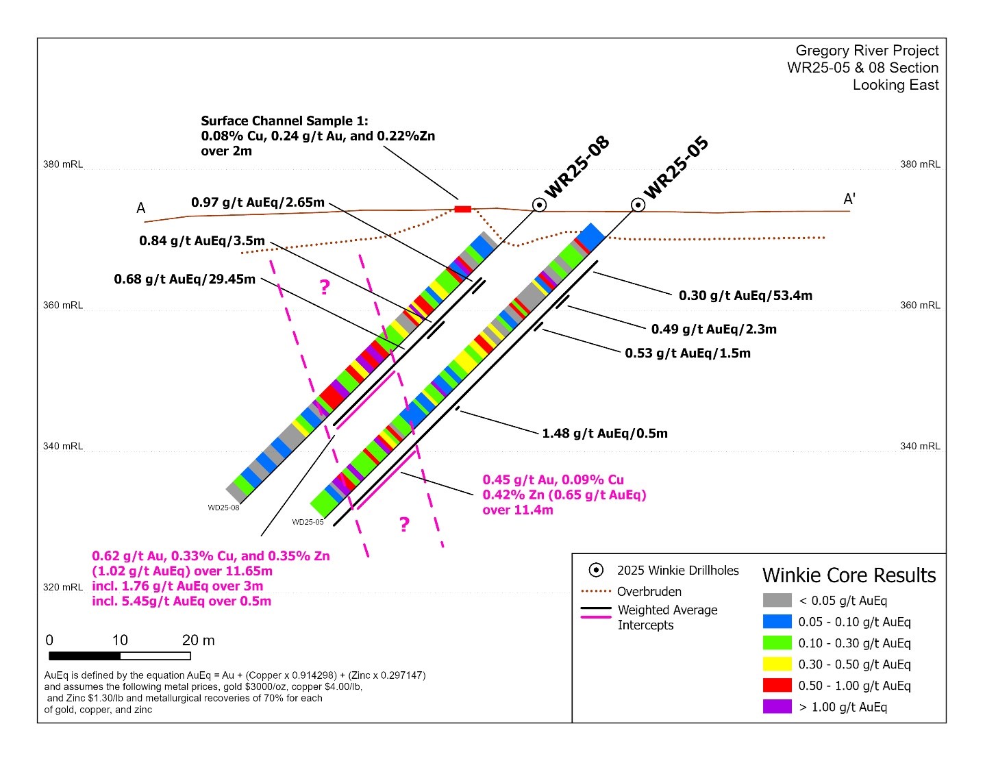
Figure 3 - Cross Section A-A' showing Drill Holes WR25-05 and 08
To view an enhanced version of this graphic, please visit:
https://images.newsfilecorp.com/files/8310/271382_ea038a87d43b7822_003full.jpg
Table 1: Lower Mitchell Target -Significant Winkie Drill Intercepts
| Drill Hole | From (m) | To (m) | Length (m) | Au (g/t) | Cu (%) | Zn (%) | AuEq (%) |
| WD25-03 | 8.2 | 13.5 | 5.3 | 0.24 | 0.08 | 0.31 | 0.40 |
| including | 12 | 13.5 | 1.5 | 0.48 | 0.19 | 0.72 | 0.86 |
| WD25-03 | 39 | 40.5 | 1.5 | 0.41 | 0.02 | 0.03 | 0.44 |
| WD25-04 | 30 | 31.5 | 1.5 | 0.24 | 0.04 | 0.04 | 0.29 |
| WD25-04 | 34.5 | 35 | 0.5 | 0.08 | 0.69 | 0.07 | 0.73 |
| WD25-05 | 9.5 | 62.9 | 53.4 | 0.16 | 0.06 | 0.28 | 0.30 |
| including | 16.1 | 18.4 | 2.3 | 0.20 | 0.13 | 0.56 | 0.49 |
| and | 21.5 | 23 | 1.5 | 0.09 | 0.22 | 0.78 | 0.53 |
| and | 38.2 | 38.7 | 0.5 | 1.21 | 0.08 | 0.68 | 1.48 |
| and | 47.1 | 58.5 | 11.4 | 0.45 | 0.09 | 0.42 | 0.65 |
| WD25-07 | 10.5 | 53.8 | 43.3 | 0.07 | 0.05 | 0.19 | 0.17 |
| including | 11 | 15.2 | 4.2 | 0.22 | 0.13 | 0.45 | 0.47 |
| WD25-08 | 13.2 | 42.65 | 29.45 | 0.34 | 0.21 | 0.51 | 0.68 |
| including | 13.2 | 15.85 | 2.65 | 0.20 | 0.37 | 1.44 | 0.97 |
| and | 21 | 24.5 | 3.5 | 0.22 | 0.24 | 1.36 | 0.84 |
| and | 31 | 42.65 | 11.65 | 0.62 | 0.33 | 0.35 | 1.02 |
| including | 31 | 34 | 3 | 1.49 | 0.15 | 0.48 | 1.76 |
| including | 31 | 32 | 1 | 3.19 | 0.09 | 0.43 | 3.40 |
| including | 31 | 31.5 | 0.5 | 5.21 | 0.08 | 0.59 | 5.46 |
There is an Insufficient amount of drilling to determine the true widths of the mineralization reported in the table; AuEq is defined by the equation AuEq =Au +(copper x 0.914298) + (zinc x 0.297147) and assumes the following metal prices, gold $3,000/oz, copper $4.00/lb, and zinc $1.30/lb and metallurgical recoveries of 70% for each of gold, copper, and zinc. No metallurgical testwork has been completed for mineralization at Lower Mitchell, and it is still considered a very early-stage prospect, however based on a review of other similar projects it is assumed that the elements included in the metal equivalent calculation have a reasonable prospect to be economically recovered.
Table 2: Lode 9 Northeast Target -Significant Winkie Drill Intercepts
| Drill Hole | From (m) | To (m) | Length (m) | Au (g/t) | Cu (%) | Zn (%) |
| WD25-01 | 7 | 9 | 2 | 0.10 | 0.54 | 0.08 |
| WD25-01 | 33.25 | 33.85 | 0.6 | 0.04 | 1.06 | 0.05 |
| WD25-02 | 34.95 | 35.7 | 0.75 | 0.21 | 0.56 | 0.02 |
There is an Insufficient amount of drilling to determine the true widths of the mineralization reported in the table.
Drilling Details
Drilling was completed by Majors Contracting Ltd., based in Deer Lake, Newfoundland and took place from July 9 to August 2, 2025, using a UTV-mounted Winkie drill rig producing AQ diameter core (27 mm). Drill holes were collared at -45° and drilled in various directions to drilled depths ranging between 34 m and 63 m. All drill holes had excellent core recovery, averaging greater than 95% recovery. Table 3 summarizes the drill hole details and Figures 1 and 2 show the locations of the drill holes.
Table 3: Gregory River 2025 Winkie Drilling - Collar Information
| Drill Hole | UTM EASTING | UTM NORTHING | Elevation (masl) | Length (m) | Azimuth (degrees) | Dip (degrees) | Target |
| WD25-01 | 419753 | 5467445 | 280 | 53.5 | 90 | -45 | Lode 9 Northeast |
| WD25-02 | 419752 | 5467443 | 280 | 51.0 | 270 | -45 | Lode 9 Northeast |
| WD25-03 | 419426 | 5465448 | 376 | 57.0 | 180 | -45 | Lower Mitchell |
| WD25-04 | 419529 | 5465393 | 387 | 51.0 | 165 | -45 | Lower Mitchell |
| WD25-05 | 419410 | 5465420 | 375 | 62.9 | 360 | -45 | Lower Mitchell |
| WD25-06 | 420132 | 5465724 | 433 | 34.5 | 180 | -45 | Vein Zone West |
| WD25-07 | 419375 | 5465450 | 372 | 53.8 | 180 | -45 | Lower Mitchell |
| WD25-08 | 419410 | 5465434 | 375 | 60.0 | 360 | -45 | Lower Mitchell |
| Total | Drilling | 423.7 |
Notes: Collar coordinates were surveyed using a handheld GPS and are reported using NAD83 datum.
Core was logged and sampled by a Golden Spike contractor (Alex Bugden, P. Geo.) at the drill site during the drilling and were logged for lithology, alteration, mineralization, veining, structure and geotechnical parameters. Given the small diameter of the core, it was decided that all core should be sampled to ensure the most representative sample. Once sample intervals were marked the samples were immediately bagged and sealed shut and sealed into rice bags. Sample lengths were variable, ranging between 0.5 m and 1.5 m and averaging 0.94 m.
Samples were delivered by Golden Spike contractors to Eastern Analytical Laboratory ("Eastern") in Springdale Newfoundland for sample preparation and analyses. Samples were crushed to 80% passing 110 mesh, and a 250 g split was pulverized to 95% passing 150 mesh. Samples were then analysed for gold by 30-gram fire assay with an AA finish and for 34 elements by ICP-OES, using a 4-acid digestion. The ICP analysis included target elements, such as copper, zinc and silver, as well as various pathfinder and other elements, including arsenic and antimony. Overlimits for copper and zinc were further analysed by Eastern. Eastern is a well-recognized laboratory, mainly servicing Newfoundland and Labrador and is independent of Golden Spike. Eastern has implemented a quality system compliant with the International Standards Organization (ISO) requirements for the competence of testing and calibration laboratories. Eastern regularly participates in the Canmet Round-Robin proficiency test and passes all criteria. In 2014 Eastern achieved ISO 17025 accreditation in fire assay gold, as well as multi-acid ore grade assays in Cu, Pb, Zn, Ag, Fe and Co.
The Company has incorporated a quality assurance/quality control ("QA/QC") program during the drill hole sampling, which includes the regular insertion of Company standards (commercially purchased certified reference material and coarse blanks at a frequency of approximately one QAQC insertion per 20 samples.
Next Steps
With the successful completion of the Winkie drilling program, the Golden Spike technical team will now focus on the integration and technical analysis of the drill results, incorporating data from surface geochemistry, field mapping and airborne geophysics to plan additional exploration at Lower Mitchell and other key targets at Gregory River. The Company is planning to complete a program of geophysics over Lower Mitchell to better understand the orientation of the mineralization followed by diamond drilling. It is important to note that the Lower Mitchell Target is relatively flat and accessible by ATV and therefore limited helicopter time would be required for drill testing this target.
The Company is planning to return to the Property later this fall to complete additional prospecting and rock/soil sampling over several key target areas that are accessible by ATV trails. The areas to be explored are being determined by the Company's exploration team and will be reported when the program is initiated.
In addition, the Company is still awaiting the analytical results of the completed grid of 623 soil samples over the Steep Brook North target area, which is a high-priority segment of the Gregory River VMS-Target Corridor that occurs immediately north of the Steep Brook target and has seen very limited amounts of historical exploration. Significant portions of the area are covered by overburden with limited amounts of outcrop exposure, making soil sampling a good first pass exploration tool to evaluate new target areas. Analytical results will be released once received and reviewed by the Company's technical team. The Company is anticipating that the soil results will be available by late October or early November.
Qualified Person
The scientific and technical information in this news release has been reviewed and approved for disclosure by Mr. Robert Cinits, P.Geo, a Director of the Company and a "Qualified Person" within the meaning of National Instrument 43-101 - Standards of Disclosure for Mineral Projects.
About Golden Spike
Golden Spike Resources Corp. (CSE: GLDS) (OTCQB: GSPRF) (FSE: L5Y) is a Canadian mineral exploration company focused on identifying, acquiring and unlocking value in mineral opportunities in Canada and other low-risk jurisdictions. The Company currently holds 100% interest in the 5,175-hectare Gregory River Property in Newfoundland, strategically centered over an approximate 11-kilometre-long stretch of the Gregory River VMS-belt, a north-northeast trending corridor of very prospective ground with potential to host Cyprus-type polymetallic VMS deposits. In addition, the Property hosts a cluster of historically explored, high-grade, copper ±gold vein structures. Golden Spike Resources remains dedicated to sustainable exploration practices and continues to collaborate with local communities, consultants, and stakeholders as it progresses its exploration initiatives.
For further information, please contact: Keith Anderson, President, Golden Spike Resources Corp. Tel: 604-786-7774, Email: kanderson7774@gmail.com
Website: https://www.goldenspikeresources.com
ON BEHALF OF THE BOARD OF DIRECTORS
Keith Anderson
Golden Spike Resources Corp.
830 - 1100 Melville St.,
Vancouver, BC, V6E 4A6
+1 (604) 786-7774
info@goldenspikeresources.com
www.goldenspikeresources.com
"Neither the Canadian Securities Exchange (the "CSE") nor its Regulation Services Provider (as that term is defined in policies of the CSE) accepts responsibility for the adequacy or accuracy of this release."
Cautionary Note Regarding Forward-Looking Statements
This release includes certain statements and information that may constitute forward-looking information within the meaning of applicable Canadian securities laws. Forward-looking statements relate to future events or future performance and reflect the expectations or beliefs of management of the Company regarding future events. Generally, forward-looking statements and information can be identified by the use of forward-looking terminology such as "intends" or "anticipates", or variations of such words and phrases or statements that certain actions, events or results "may", "could", "should", "would" occur.
Additionally, forward-looking information involve a variety of known and unknown risks, uncertainties and other factors which may cause the actual results to be materially different from any future plans, intentions, activities, results, performance or achievements expressed or implied by such forward-looking statements. Such risks include, without limitation: the volatility of global capital markets, political instability, unanticipated costs, risks relating to the extent and duration of the conflict in Eastern Europe and its impact on global markets, the lack of availability of capital and financing, general economic, market or business conditions, adverse weather conditions, failure to maintain all necessary government permits, approvals and authorizations, failure to maintain community acceptance (including First Nations), increase in costs, litigation, failure of counterparties to perform their contractual obligations, failure of the exploration program, including the recent IP survey and the recent drilling programs to result in the discovery of significant precious and/or base metal mineralization, and those risks, uncertainties and factors set forth in the Company's disclosure record under the Company's profile on SEDAR+ at www.sedarplus.ca . Although management of the Company has attempted to identify important factors that could cause actual results to differ materially from those contained in forward-looking statements or forward-looking information, there may be other factors that cause results not to be as anticipated, estimated or intended. Accordingly, readers should not place undue reliance on forward-looking statements and forward-looking information contained herein. Readers are cautioned that reliance on such information may not be appropriate for other purposes. The Company does not undertake to update any forward-looking statement or forward-looking information disclosed herein, except in accordance with applicable securities laws.
![]()
To view the source version of this press release, please visit https://www.newsfilecorp.com/release/271382
Source: Golden Spike Resources Corp.