Exciting growth opportunities at Brucejack, Red Chris and Havieron continue to deliver high grade results
At Brucejack, drilling confirms the potential for resource growth at the Valley of the Kings deposit, with further high grade returned from North Block and 1080 Level East, which are both located outside the current resource.
At North Block, VU-3489 returned 28.5m @ 262g/t Au from 70.5m, including 1.0m @ 7,400g/t Au from 87m.
At 1080 Level East, VU-3570 returned 17m @ 41g/t Au from 189m, including 1m @ 662g/t Au from 205m, and 16.5m @ 35g/t Au from 252m, including 1m @ 205g/t Au from 252m and including 1m @ 316g/t Au from 266m, and 34.5m @ 16g/t Au from 286.5m, including 1m @ 359g/t Au from 301m.
Drilling has also expanded the footprint of the high grade mineralisation at Golden Marmot, located 3.5 kilometres north of the Brucejack Mine.
- At Golden Marmot, SU-786 returned 20.0m @ 187g/t Au from 268m, including 0.5m @ 6,700g/t Au from 270.5m and including 0.5m @ 770g/t Au from 285m. In addition, SU-843 returned 38.5m @ 27g/t Au from 106.5m, including 0.5m @ 1,925g/t Au from 138.3m, and 21m @ 6.9g/t Au from 187.5m, including 0.5m @ 250g/t Au from 188.4m.
At Red Chris, drilling continues to expand the footprint and confirm continuity of higher grade mineralisation at East Ridge.
RC750W returned 96m @ 0.77g/t Au & 0.61% Cu from 1,454m, including 46m @ 1.3g/t Au & 1.0% Cu from 1,502m and 82m @ 0.69g/t Au & 0.61% Cu from 1,578m, including 32m @ 1.2g/t Au & 1.0% Cu from 1,582m. RC779 returned 560m @ 0.35g/t Au & 0.45% Cu from 1,216m, including 98m @ 0.59g/t Au & 0.72% Cu from 1,502m, including 12m @ 1.1g/t Au & 1.2% Cu from 1,542m. Both RC750W and RC779 remain open at depth.
RC785 extended the corridor to the east, a further 100m beyond RC740 (previously reported) returning 214m @ 0.26g/t Au & 0.37% Cu from 1,532m, including 24m @ 0.83g/t Au & 1.1% Cu from 1,532m. RC785 is also the deepest significant intercept returned from East Ridge and remains open at depth and to the east.
Drilling to define the extent of the East Ridge mineralised corridor is ongoing.
At Havieron, growth drilling continues to expand the system footprint and identify high grade extensions to the mineralisation in the Eastern Breccia, South East Crescent Zone, Northern Breccia and North West Pod target areas. Highlights include:
In the Eastern Breccia, new results from HAD145W1 returned 150.1m @ 3.7g/t Au & 0.15% Cu from 1,827.9m, including 42.3m @ 8.6g/t Au & 0.4% Cu from 1,854m. The intercept is approximately 100m to the north west of HAD104^^ which returned 62.5m @ 5.9g/t Au & 0.30% Cu from 1,546.5m, including 49.4m @ 7.1g/t Au & 0.38% Cu from 1,554.6m. These intercepts confirm the potential for the North West trending Eastern Breccia corridor to host Crescent style high grade mineralisation.
In the South East Crescent, results for HAD133W6^ were received which finalises the reported intercept to 173.2m @ 1.9g/t Au & 0.18% Cu from 1,424.6 m, including 43.1m @ 3.7g/t Au & 0.34% Cu from 1,425.9m. This intercept is the deepest high-grade mineralised intercept for the project to date, at approximately 250m below the current Mineral Resource and demonstrates that the high grade mineralisation remains open at depth.
In the Northern Breccia and North West Pod targets, crescent-like intercepts have been returned in infill drilling with HAD089W4 intersecting 52.7m @ 7.1g/t Au & 0.04% Cu from 1,074m including 31.4m @ 12g/t Au & 0.03% Cu from 1,094.9m on the northwest margin of the breccia. In addition, HAD085W6 intersected 52m @ 3.0g/t Au & 0.09% Cu from 1,327m including 17.9m @ 7.7g/t Au & 0.07% Cu from 1,361.1m within the Northern Breccia Inferred Resource.
Melbourne, Australia--(Newsfile Corp. - April 27, 2022) - Newcrest (ASX: NCM) (TSX: NCM) (PNGX: NCM) Managing Director and Chief Executive Officer, Sandeep Biswas, said, "We are absolutely delighted to release the exceptional drilling results at Brucejack today, following completion of the Pretium transaction in March 2022. Brucejack is very early in its mine life and offers significant exploration upside with the land package largely unexplored. The drilling results today confirm the significant upside potential adjacent to and beyond the Valley of the Kings deposit with high grade intercepts identified in a number of targets outside of the current resource. Golden Marmot has also delivered incredible results, further expanding the footprint of high grade mineralisation and creating exciting potential."
"The results at our East Ridge discovery at Red Chris continue to expand the higher grade footprint of the mineralised corridor, with the strike extents of this prospect remaining open to the east and at depth. Havieron also continues to deliver encouraging results, with several high grade drill results in target areas including the Eastern Breccia that sit outside of our Inferred Mineral Resource estimate." said Mr Biswas.
Brucejack, British Columbia, Canada(1)
In March 2022, Newcrest completed the acquisition of Pretium Resources Inc. (Pretium), owner of the Brucejack mine located 65km northwest of Stewart in northern British Columbia, Canada.
The Brucejack Property hosts the Valley of the Kings high-grade gold deposit. The nature of the mineralisation at the Valley of the Kings deposit is characterised by multiple occurrences of higher grade over selected intervals hosted within broader zones of stockwork and vein arrays. Growth activities are focused on both resource expansion within the existing mine area, as well as brownfields exploration activities within 4kms of the mine area. Both work programs delivered very strong results for the period.
Resource expansion drilling was focused on newly defined targets in the 1080 HBx Zone, Eastern Promises and Bridge Zone. A total of 12,278m in 65 drill holes were completed using 3 drill rigs and assays are pending. During the quarter, final assay results were received from the North Block Phase 4, 1080 Level East and Golden Marmot programs.
At North Block Phase 4, 11,465m of resource expansion drilling was completed in 60 drill holes extending the footprint of the mineralisation. All drill holes intersected gold mineralisation, with 11 of the 60 drill holes intersecting higher grade, in excess of 5 grams per tonne gold. Phase 4 drilling extended the North Block an additional 100 meters to the west, with the majority of the high-grade gold mineralisation located within 25m of existing infrastructure.
Drilling at North Block has now expanded the zone over an area 375m wide, 350m long, and 300m high. North Block remains open to the north and at depth and is currently outside the existing Mineral Resource estimate. Definition drilling is currently underway.
Results for the reporting period include:
- VU-3469
- 60m @ 31g/t Au from 39m
- including 1m @ 527g/t Au from 39m
- including 1m @ 1,235g/t Au from 79m
- VU-3474
- 46.5m @ 20g/t Au from 6m
- including 1m @ 911g/t Au from 21.7m
- VU-3478
- 16.5m @ 34g/t Au from 42m
- including 1m @ 547g/t Au from 42m
- VU-3489
- 28.5m @ 262g/t Au from 70.5m
- including 1m @ 7,400g/t Au from 87m
At 1080 Level East, 15,618m of drilling was completed in 65 drill holes. Fifty-nine (59) drill holes intersected gold mineralisation, with 13 of the 65 drill holes intersecting higher grade, in excess of 5 grams per tonne gold. Drilling was planned to infill the initial 4 drill fans completed in 2020, with the results showing continuity of gold mineralisation up to 100 meters east and 200 meters below the existing Mineral Resource Estimate.
Drilling at 1080 East Level has now expanded the zone over an area 150m wide, 250m long, and 200m high. 1080 East Level remains open to the south, east, and at depth. Follow up drilling is currently underway in the 1080 HBx Zone towards the south, where extended drill holes from the 2021 program encountered gold mineralisation, with drilling also planned for Eastern Promises towards the east.
Results for the reporting period include:
- VU-3417
- 21m @ 15g/t Au from 72m
- including 1m @ 252g/t Au from 83.5m
- VU-3490
- 22m @ 17g/t Au from 180m
- including 1m @ 248g/t Au from 201m
- VU-3568
- 19.5m @ 21g/t Au from 214.5m
- including 1m @ 370g/t Au from 227.1m
- VU-3570
- 17m @ 41g/t Au from 189m
- including 1m @ 662g/t Au from 205m
- 16.5m @ 35g/t Au from 252m
- including 1m @ 205g/t Au from 252m
- including 1m @ 316g/t Au from 266m
- 34.5m @ 16g/t Au from 286.5m
- including 1m @ 359g/t Au from 301m
At Golden Marmot, brownfield activities included 8,378m of drilling in 26 drill holes. All drill holes intersected gold mineralisation, with 7 of 26 drill holes intersecting higher grade, in excess of 5 grams per tonne gold.
Golden Marmot is part of a four-kilometre trend of highly altered rocks which outcrop from Hanging Glacier in the northwest to Bridge Zone in the southeast. The area is accessible via exploration trail from the Brucejack Mine. Mineralisation at Golden Marmot occurs as coarse-grained electrum hosted in strongly quartz-sericite-pyrite altered volcanic and sedimentary facies of the Lower Hazelton Group. Results from the initial drilling identified 7 preliminary mineralisation domains broadly trending east-west and north-south. To date, these domains extend over an area 250m wide, 300m long, and 300m high and display many of the salient geological features that characterise the Valley of the Kings deposit immediately to the south.
Mineralisation at Golden Marmot remains open in all directions and to depth. Golden Marmot is a new discovery located outside of the Mineral Resource estimate. Follow up drilling is currently being planned for the 2022 exploration field season.
Results for the reporting period include:
- SU-772
- 19m @ 36g/t Au from 114m
- including 1m @ 268g/t Au from 124m
- including 1m @ 233g/t Au from 130.9m^^
- SU-786
- 20m @ 187g/t Au from 268m
- including 0.5m @ 6,700g/t Au from 270.5m
- including 0.5m @ 770g/t Au from 285m^^
- SU-800
- 17m @ 32g/t Au from 192m
- including 0.5m @ 1,055g/t Au from 198m
- 30.9m @ 16g/t Au from 272.5m
- including 1.04m @ 351g/t Au from 282.42m
- SU-843
- 38.5m @ 27g/t Au from 106.5m
- including 0.5m @ 1,925g/t Au from 138.3m
- 21m @ 6.9g/t Au from 187.5m
- including 0.5m @ 250g/t Au from 188.4m
Approximately 54,000m of resource expansion drilling and 35,000 meters of brownfield exploration drilling targeting mineralisation definition and continuity are planned during calendar year 2022 with three drill rigs underground and four drill rigs on surface.
Refer to Appendix 1 for additional information, and the Drill hole data table for all results reported during the period.

Figure 1. Plan view map of the Brucejack Property, spanning the 4km gossanous trend from Golden Marmot in the north to Bridge Zone in the South. Cross section for Figure 2 views parallel to the Brucejack Fault.
To view an enhanced version of Figure 1, please visit:
https://orders.newsfilecorp.com/files/7614/121968_newcrestfigure1.jpg

Figure 2. Long section view (looking west) of the Brucejack Property.
To view an enhanced version of Figure 2, please visit:
https://orders.newsfilecorp.com/files/7614/121968_newcrestfigure2.jpg

Figure 3. Plan view map of the 1080 level in the Brucejack Mine, showing the North Block Phase 4 and 1080 East Level drill programs, gold assays >5g/t Au, and the modelled extents of two prominent domains, Domain 13 and Domain 20.
To view an enhanced version of Figure 3, please visit:
https://orders.newsfilecorp.com/files/7614/121968_newcrestfigure3.jpg

Figure 4. Plan view map of the Golden Marmot prospect showing drill results, gold assays >1g/t and preliminary domains.
To view an enhanced version of Figure 4, please visit:
https://orders.newsfilecorp.com/files/7614/121968_newcrestfigure4.jpg
Red Chris, British Columbia, Canada(2)
Red Chris is a joint venture between Newcrest (70%) and Imperial Metals Corporation (30%) which is operated by Newcrest.
The Brownfield Exploration program is focused on the discovery of additional zones of higher-grade mineralisation within the Red Chris porphyry corridor, including targets outside of Newcrest's initial Mineral Resource estimate. During the period, there were up to eight diamond drill rigs in operation. A further 17,543m of drilling has been completed from 20 drill holes, with all drill holes intersecting mineralisation (except 10 drill holes which were dedicated geotechnical holes). This contributed to a total of 234,892m of drilling from 219 drill holes since Newcrest acquired its interest in the joint venture in August 2019.
At East Ridge, located adjacent to the East Zone, drilling is ongoing with 38 holes completed and 5 in progress. The follow up drilling is being completed on a nominal 100m x 100m grid to determine the footprint of the mineralisation, characterise the mineralisation and demonstrate the continuity of the higher-grade mineralisation. Drilling to date has tested a corridor 800m long and to a vertical extent of 1,000m within which zones of higher grade mineralisation have been identified.
Results for the reporting period include:
- RC750W
- 96m @ 0.77g/t Au & 0.61% Cu from 1,454m
- including 46m @ 1.3g/t Au & 1.0% Cu from 1,502m
- 82m @ 0.69g/t Au & 0.61% Cu from 1,578m
- including 32m @ 1.2g/t Au & 1.0% Cu from 1,582m
- RC773
- 256m @ 0.34g/t Au & 0.47% Cu from 826m,
- including 54m @ 0.82g/t Au & 0.89% Cu from 958m,
- including 18m @ 1.4g/t Au & 1.3% Cu from 994m
- 168m @ 0.51g/t Au & 0.51% Cu from 1,276m
- including 24m @ 2.8g/t Au & 1.8% Cu from 1,278m
- including 22m @ 2.9g/t Au & 1.9% Cu from 1,278m
- RC777
- 480m @ 0.42g/t Au & 0.41% Cu from 1,012m
- including 78m @ 0.79g/t Au & 0.74% Cu from 1,324m
- including 10m @ 1.6g/t Au & 1.1% Cu from 1,324m
- RC779
- 560m @ 0.35g/t Au & 0.45% Cu from 1,216m
- including 98m @ 0.59g/t Au & 0.72% Cu from 1,502m
- including 12m @ 1.1g/t Au & 1.2% Cu from 1,542m
- RC785
- 214m @ 0.26g/t Au & 0.37% Cu from 1,532m
- including 24m @ 0.83g/t Au & 1.1% Cu from 1,532m
Drilling continues to define the continuity of the higher grade. Holes RC750W, RC773, RC777 and RC779 all returned higher grade with holes RC750W and RC777 remaining open at depth.
Drilling also continues to expand the strike extent of the East Ridge mineralisation. RC785 located a further 100m east of RC740 (previously reported) returned 214m @ 0.26g/t Au & 0.37% Cu from 1,532m, including 24m @ 0.83g/t Au & 1.1% Cu from 1,532m. RC785 also returning the deepest significant intercept on the property which remains open at depth and further east.
The East Ridge mineralised corridor (>0.4g/t Au and >0.4% Cu) extends over 800m long, up to 1,000m high and 125m wide, with higher grade (>0.8g/t Au and >0.8% Cu) in several smaller pods over an area 500m high, 400m long and 100m wide.
East Ridge is located east of East Zone and is outside of Newcrest's initial Mineral Resource estimate. Follow-up drilling is in progress to further define the extent and continuity of this high grade mineralisation.
At Main Zone, final results were returned from a nominal 100 x 100m grid southwest of the open pit, following up RC679^^ (previously reported) which returned 456m @ 0.37g/t Au & 0.42% Cu from 418m, including 98m @ 0.71g/t Au & 1.0% Cu from 440m. Several significant intercepts were returned from RC753, RC765, RC769, RC775, RC776, RC778 and RC782 with the results being reviewed to determine further follow up. Drilling is planned northwest of the open pit targeting higher-grade intercepts to the west and at depth beneath the current open pit, external to the current resource.
Approximately 50,000m of growth-related drilling targeting mineralisation definition and continuity is planned for calendar year 2022 from eight drill rigs.
Refer to Appendix 2 for additional information, and the Drillhole data table for all results reported during the period.

Figure 5. Schematic plan view map of the Red Chris porphyry corridor spanning East Ridge, East Zone, Main Zone and Gully Zone showing significant Newcrest intercepts (drill intercepts have been reported in Appendix 2 of this report), 0.3g/t Au, 1g/t Au, 0.3% Cu and 1% Cu shell projections generated from a LeapfrogTM model.
To view an enhanced version of Figure 5, please visit:
https://orders.newsfilecorp.com/files/7614/121968_newcrestfigure5.jpg

Figure 6. Long section view (looking North West) of the Red Chris porphyry corridor showing drill hole locations and gold distribution.
To view an enhanced version of Figure 6, please visit:
https://orders.newsfilecorp.com/files/7614/121968_newcrestfigure6.jpg

Figure 7. Oblique schematic section view of the Red Chris porphyry corridor showing gold distribution. 0.3 g/t Au,1 g/t Au, 0.3% Cu and 1% Cu shell projections generated from the LeapfrogTM model.
To view an enhanced version of Figure 7, please visit:
https://orders.newsfilecorp.com/files/7614/121968_newcrestfigure7.jpg
Havieron Project, Western Australia, Australia(3)
The Havieron Project is operated by Newcrest under a Joint Venture Agreement (JVA) with Greatland Gold. Newcrest holds a 70% interest in the Havieron Project and has an option to acquire an additional 5% joint venture interest at fair value. Newcrest continued to progress the process to determine the option price for the 5% joint venture interest in accordance with the JVA during the period. The JVA includes tolling principles reflecting the intention of the parties that, subject to a successful exploration program, Feasibility Study and a positive decision to mine, the resulting joint venture mineralised material will be processed at Telfer.
The Havieron Project is centred on a deep magnetic anomaly located 45km east of Telfer in the Paterson Province. The deposit is overlain by more than 420m of post mineral Permian cover. The Joint Venture commenced drilling during the June 2019 quarter and has completed 237,444m of drilling from 285 drill holes to date (excluding holes in progress, abandoned holes, or drill holes which have not been sampled).
Drilling activities in the period have produced a further 10,952m of drilling from 13 holes. New assay results are reported from 15 drill holes, including additional results reported for 2 holes for which partial results were reported during the December 2021 quarter. Of the reported holes, 10 holes returned significant assay intercepts in excess of 50 gram metres Au (Au ppm x length m).
Drilling in the quarter was focused on potential resource growth at the South East Crescent Zone, Northern Breccia, Eastern Breccia and regional exploration holes outside the main Havieron mineralised system. Assays reported include drilling from:
- South East Crescent Deeps - assay results reported for four drill holes, two holes awaiting assays.
- Northern Breccia & North West Pod - assay results reported for five drill holes, one further drill hole was completed for geotechnical investigations and was not assayed.
- Eastern Breccia - assay results reported for four drill holes, two holes awaiting assays.
- First pass drill testing of geophysical targets outboard of the Havieron system, with two drill holes reported from Zipa, and two drill holes pending from step out drilling north and south of the Havieron system.
At the Eastern Breccia, assays for an additional four holes targeting strike extensions from previously reported drill holes have been received. As reported in the December 2021 quarter, HAD104^^ returned 62.5m @ 5.9g/t Au & 0.30% Cu from 1,546.5m, including 49.4m @ 7.1g/t Au & 0.38% Cu from 1,554.6m, approximately 200m to the southwest of previous drilling. New results from HAD145W1 testing approximately 100m to the northwest of HAD104 has returned 150.1m @ 3.7g/t Au & 0.15% Cu from 1,827.9m, including 42.3m @ 8.6g/t Au & 0.4% Cu from 1,854m.
HAD104^^ and HAD145W1 represent the most significant intercepts in the Eastern Breccia zone to date and confirm the potential for this separate northwest trending corridor to host crescent style high grade mineralisation. Drilling is now focused on defining the extents of this higher-grade mineralisation which remains open in all directions.
Results include:
- HAD093
- 76.7m @ 1.9g/t Au & 0.07% Cu from 1,306.1m
- including 18.2m @ 3.7g/t Au & 0.17% Cu from 1,347.8m
- HAD104^
- 62.5m @ 5.9g/t Au & 0.30% Cu from 1,546.5m
- including 49.4m @ 7.1g/t Au & 0.38% Cu from 1,554.6m
- 85m @ 1.2g/t Au & 0.37% Cu from 1,717m
- HAD145W1
- 59.2m @ 0.91g/t Au & 0.14% Cu from 1,633m
- 32.9m @ 1.5g/t Au & 0.63% Cu from 1,730.4m
- 150.1m @ 3.7g/t Au & 0.15% Cu from 1,827.9m
- including 42.3m @ 8.6g/t Au & 0.4% Cu from 1,854m
- HAD152
- 63m @ 0.98g/t Au & 0.13% Cu from 1,767m
South East Crescent Deeps growth drilling continued during the quarter targeting higher grade mineralisation at depth below the current Mineral Resource. Results were received from three drill holes, and updated results from one drill hole HAD133W6^, which is now reported in full. Results from HAD133W7 and HAD133W8 are approximately 250m below the Inferred Mineral Resource and west of what is interpreted to be the steeply southeast plunging high grade Crescent Zone. The best mineralisation to date is developed next to the dolerite dyke in HAD133W6^ which returned 173.2m @ 1.9g/t Au & 0.18 % Cu from 1,424.6 m, including 43.1m @ 3.7g/t Au & 0.34% Cu from 1,425.9m, which remains the deepest high-grade mineralised intercept for the project to date, at approximately 250m below the current Mineral Resource estimate. Further drilling is planned to test potential for high-grade resource extensions.
Results include:
- HAD085W7
- 35.7m @ 2.3g/t Au & 0.04% Cu from 1,534m
- HAD133W6^
- 173.2m @ 1.9g/t Au & 0.18% Cu from 1,424.6m
- including 43.1m @ 3.7g/t Au & 0.34% Cu from 1,425.9m
- HAD133W7
- 22.7m @ 1.2g/t Au & 0.08% Cu from 1,525.3m
- HAD133W8
- 41.6m @ 0.82g/t Au & 0.07% Cu from 1,471.9m
- including 13m @ 1.4g/t Au & 0.14% Cu from 1,474m
Northern Breccia infill drilling has targeted known high-grade mineralisation around the North West Pod (NW Pod) Target on the northwest margin of the Breccia, in addition to internal higher-grade mineralisation within the core of the Breccia. Both high grade "NW Pod" mineralisation (hole HAD089W4) and broader lower grade Northern Breccia mineralisation (HAD093) were intersected.
Results include:
- HAD085W6
- 64.4m @ 2.1g/t Au & 0.06% Cu from 1,174.3m
- including 23.7m @ 5.3g/t Au & 0.1% Cu from 1,199.6m
- 52m @ 3.0g/t Au & 0.09% Cu from 1,327m
- including 17.9m @ 7.7g/t Au & 0.07% Cu from 1,361.1m
- HAD089W4
- 52.7m @ 7.1g/t Au & 0.04% Cu from 1,074m
- including 31.4m @ 12g/t Au & 0.03% Cu from 1,094.9m
- HAD093
- 273.6m @ 1.1g/t Au & 0.14% Cu from 886.6m
- HAD104^^
- 20.1m @ 3.4g/t Au & 0.43% Cu from 835m.
- 136.4m @ 0.72g/t Au & 0.09% Cu from 956.2m.
- HAD141W2
- 88m @ 0.98g/t Au & 0.03% Cu from 1,314m
Drilling to test geophysical targets outside of the known Havieron system is ongoing, including evaluating the Havieron dolerite at multiple intervals north and south of the Havieron mineralised pipe. HAD154 and HAD155 tested the Havieron dolerite 400m north and south of Havieron respectively, with results pending. Results were received for ZIP001 and ZIP002, testing the Zipa target, located approximately 2km to the north of Havieron and centred on a prominent gravity high anomaly. No significant results were reported for the two completed Zipa drillholes, although both holes intersected diorite like lithologies in metasediment, a rock type considered significant to mineralisation at Havieron.
The reduced quantity of holes and new assays reported in this period reflect the seasonal reduction in drill rigs over the wet season. Drilling activity has returned to seven drill rigs. Growth drilling targeting mineralisation definition and continuity continues to show potential for resource additions outside of the existing Inferred Mineral Resource limits, including:
- Extension of the South East Crescent Zone at depth below the Updated Mineral Resource
- Expansion of multiple higher-grade zones including Northern Breccia and North West Pod
- Extensions of the Eastern Breccia including definition of internal higher grade zones identified in HAD104^^ and HAD145W1
- Drilling is continuing to target geophysical targets outside of the main Havieron system.
Refer to Appendix 3 for additional information and Drillhole data table for all results reported during the period.

Figure 8. 3D Plan view schematic showing the spatial association north-west trending mineralised corridors which host the South East Crescent, Northern Breccia, North West Pod and Eastern Breccia targets in relation to the Inferred Resource extents. Also highlighted are selected previously reported intercepts >100 gram metres (Au ppm x length) that have been intersected outside of the Inferred Mineral Resource.
To view an enhanced version of Figure 8, please visit:
https://orders.newsfilecorp.com/files/7614/121968_newcrestfigure8.jpg

Figure 9. 3D oblique view of the Havieron system viewed from the south-east, showing the position of high-grade intercepts and mineralised zones outside of the current Mineral Resource extents. Further higher-grade mineralisation and assay results continue to support incremental expansion of the northern breccia, as well as significant extensions for the South East Crescent deeps and Eastern Breccia targets outside of the current Inferred Resource.
To view an enhanced version of Figure 9, please visit:
https://orders.newsfilecorp.com/files/7614/121968_newcrestfigure9.jpg

Figure 10. Plan view schematic of a horizontal slice at 3850mRL through the Crescent Sulphide Zone and Breccia-hosted Zones, showing the extents of the 0.5 and 1.0 g/t Au LeapfrogTM grade shells with highlighted newly reported intercepts for this period. This diagram highlights >50gram metres intersections drilled during the period which are, refer to inset diagram for relationship to all Havieron drilling.
To view an enhanced version of Figure 10, please visit:
https://orders.newsfilecorp.com/files/7614/121968_newcrestfigure10.jpg
Wilki Project, Western Australia, Australia
The Wilki Project is an exploration farm-in and joint venture with Antipa Minerals Limited (Antipa). The project area covers a strategic landholding of ~2,200km2 surrounding the Telfer operation and is adjacent to the Havieron Project. Newcrest entered into this exploration farm-in and joint venture agreement with Antipa on 11 March 2020. Newcrest currently has a 9.9% shareholding in Antipa.
As previously highlighted, Newcrest has elected to proceed to the next stage (Stage 1) of the farm-in agreement following completion of the initial exploration expenditure commitment (A$6 million). Newcrest has the potential to earn a 51% joint venture interest in the Wilki Project through expenditure of a further A$10 million by March 2025 during Stage 1(4).
Field programs are in preparation and will be ready for execution once access can be safely obtained following the wet season.
Juri Joint Venture, Western Australia, Australia
The Juri Joint Venture is a farm-in and joint venture agreement with Greatland Gold with respect to the Black Hills and Paterson Range East projects, located within the Paterson Province approximately 50km from the Telfer operation and in proximity to the Havieron Project. The joint venture covers an area of approximately 248km2.
As previously highlighted, Newcrest has met the Stage 1 exploration expenditure (A$3 million) and now holds a 51% interest in the Juri Joint Venture. Under the terms of the agreement, Newcrest has the potential to earn an additional 24% joint venture interest (for a cumulative 75% joint venture interest) through expenditure of a further A$17 million over three years during Stage 2(4).
Field programs are in preparation and will be ready for execution once access can be obtained following the wet season.
Tennant East, Northern Territory, Australia
Work programs have identified 6 undercover targets at the Tennant East project (located 200km east of Tennant Creek). Targets for scout drilling in calendar year 2022 have been identified on the basis of coincident gravity, magnetic and induced polarisation anomalies.
Nevada, USA
Newcrest has provided notice of termination with respect to the remaining option agreements underlying the Jarbidge project.
Drilling commenced at the Fortuity89 project in south-western Nevada. Five RC drill holes have been completed for 1,663m. Samples have been submitted for assay and results are pending.
Central Andes, Northern Chile
Drilling was conducted across Newcrest's Chilean exploration project portfolio with 2,216m drilling completed during the quarter at Mioceno (Option and Farm-in Agreement with Cornerstone Capital Resources Inc.) and Esparta (Option Agreement with private individuals). Complete assays were received, with no significant results and interpretation of the data is ongoing.
A geochem survey (soils and lag) combined with detailed geological reconnaissance was conducted over prospective areas of the Gorbea-Mioceno-Silencio district during the quarter with a focus on high sulphidation epithermal systems.
During the quarter, Newcrest exited the Vicuna farm-in and option agreement with Compañía Minera del Pacífico.
Northern Andes, Ecuador
Scout drilling continued at the Gamora Project, located in southeast Ecuador. This work is being conducted by Newcrest as the operator under an earn-in agreement with Lundin Gold. Pursuant to which Newcrest can earn up to a 50% interest in eight exploration concessions. During the period, Newcrest met the Stage One expenditure requirements (US$4 million) and now has the option to elect to move to Stage Two, which includes expenditure of US$6 million over 18 months for a 25% interest. The concession area covers strategic landholdings to the north and south of Lundin Gold's Fruta del Norte mining operation.
The program at Gamora is focused on testing priority copper-gold porphyry targets. Two core holes were completed during the quarter which detected low-level porphyry style copper mineralisation. Drilling is ongoing.
During the quarter, Newcrest gave notice to exit the Cana Brava farm-in and option agreement with Cornerstone Capital Resources Inc.
Appendix 1
Brucejack (100% Newcrest): JORC Table 1
Section 1: Sampling Techniques and Data
| Criteria | Commentary |
| Sampling techniques | Core samples are obtained from core drilling. HQ diameter diamond core was drilled on a 3m run. Core was whole core sampled at 1.5m intervals except where visible gold was identified, in which case the sample was shortened to 1.0 or 0.5m. |
| Drilling techniques | Core drilling was advanced with HQ diameter coring configuration. Core from select inclined drill holes are oriented on 3m runs using an electronic core orientation tool (Reflex ACTIII). At the end of each run, the bottom of hole position is marked by the driller, which is later transferred to the whole drill core run length with a bottom of hole reference line. |
| Drill sample recovery | Core recovery is systematically recorded from the commencement of coring to end of hole, by reconciling against driller's depth blocks in each core tray with data recorded in the database. Drillers depth blocks provided the depth, interval of core recovered, and interval of core drilled. Core recoveries were typically 100%, with isolated zones of lower recovery. |
| Logging | Geological logging recorded qualitative descriptions of lithology, alteration, mineralisation, veining, and structure (for all core drilled - 35,461m). Geotechnical measurements were recorded including Rock Quality Designation (RQD) fracture frequency, solid core recovery and qualitative rock strength measurements. All geological and geotechnical logging was conducted at the Brucejack Mine. Digital data logging was captured, validated and stored in a GeoSpark database. All drill cores were photographed, prior to sampling the core. |
| Sub-sampling techniques and sample preparation | Sampling, sample preparation and quality control protocols are considered appropriate for the material being sampled. Golden Marmot: Half core HQ samples; split by saw and sampled at the Brucejack Core Facility. Half core samples of typically 1.5m were collected in plastic bags together with pre-numbered sample tags and grouped into shipping bins for dispatch to the laboratory. Sample weights typically varied from 5-7 kg, with an average of 5.6 kg. Sample sizes are considered appropriate for the style of mineralisation and project phase. North Block Phase 4 and 1080 East Level: Whole core HQ samples. Whole core samples were collected in plastic bags together with pre-numbered sample tags and grouped into shipping bins for dispatch to the laboratory by dedicated transport. Sample lengths were typically 1.5m, and weights typically varied from 11 to 15kg, with an average weight of approximately 12.5 Kg. Sample sizes are considered appropriate for the style of mineralisation. All drill core samples were freighted by road to the laboratory via hired transport. Golden Marmot: Sample preparation was conducted at the independent ISO 9001 certified and ISO 17025 accredited ALS Global preparation laboratories. Samples were dried at 600C, and crushed to 90% passing 2 mm, and split to obtain up to 500 g sub-sample, which was pulverised to a minimum fineness standard of 85% passing 75μm. Duplicate samples were reported for crush and pulp samples at a rate of 1:20. Duplicate results show an acceptable level of variability for the material sampled and style of mineralisation. Half core duplicate samples were also obtained for Golden Marmot at a rate of 1 in 20 for the majority of holes. North Block Phase 4 and 1080 East Level: Sample preparation was conducted at the independent ISO 9001 certified and ISO 17025 accredited ALS Global preparation laboratories. Samples were dried at 600C, and crushed to 90% passing 2 mm, and split to obtain up to 1 kg sub-sample, which was pulverised (using LM2) to produce a pulped product with the minimum standard of 85% passing 75μm. Duplicate sample data are available from crush and pulp samples at a rate of approximately 1:20. Duplicate results show an acceptable level of variability for the material sampled and style of mineralisation. |
| Quality of assay data and laboratory tests | Golden Marmot: Assaying of drill core samples was conducted at ALS in North Vancouver. All samples were assayed for 48 elements using a 4-acid digestion followed by ICP-AES/ICP-MS determination (method ME-MS61). Gold analyses were determined by 30g fire assay with atomic absorption finish (Au-AA23; with trigger to Au-Gra21 30g gravimetric overlimit at 10 ppm). North Block Phase 4 and 1080 East Level: Assaying of drill core samples was conducted at ALS in North Vancouver. All samples were assayed for 33 elements using a 4-acid digestion followed by ICP-OES determination (method ME-ICP61). Gold analyses were determined by 50g fire assay with atomic absorption finish (method Au-AA26; with trigger to Au-Gra22 50g gravimetric overlimit method at 18 ppm). Sampling and assaying quality control procedures consisted of inclusion of certified reference material (CRMs), coarse residue and pulp duplicates with each batch (at least 1:20). Assays of quality control samples were compared with reference samples in the Geospark SQL database and verified as acceptable prior to formal use of data from analysed batches. Laboratory quality duplicates including replicates and preparation duplicates are captured in the Geospark SQL database and assessed. Prepared pulp splits for mineralized samples were sent to MS Analytical Labs in Langley BC for secondary lab check work by comparable Au and ICP methods to ensure agreement with original results; check pulps were prepared for 20 samples, from 5 of the Golden Marmot holes, and overall a representative 5-7% of mineralized samples for VOK drilling was sent for secondary lab checks, including North Block Phase 4 and 1080 East level drilling. Comparisons are acceptable. Analysis of the available quality control sample assay results indicates that an acceptable level of accuracy and precision has been achieved. The database contains no analytical data that has been numerically manipulated. The assaying techniques and quality control protocols used are considered appropriate for the data to be used for reporting exploration drilling results. |
| Verification of sampling and assaying | Sampling intervals defined by the geologist are electronically assigned sample identification numbers prior to core sampling. Corresponding sample numbers matching pre-labelled sample tags are assigned to each interval. All sampling and assay information were stored in a secure GeoSpark database with restricted access. Sample submission forms providing the sample identification number accompany each submission to the laboratory. Assay results from the laboratory with corresponding sample identification are loaded directly into the GeoSpark database. Assessment of reported significant assay intervals was verified by review of visible gold identified in the drill core and review of high resolution core photography. The verification of significant intersections has been completed by company personnel and the Competent Person/Qualified Person. No adjustments are made to assay data, and no twinned holes have been completed. Drilling intersects mineralisation at various angles. There are no currently known drilling, sampling, recovery, or other factors that could materially affect the accuracy or reliability of the data. |
| Location of data points | All collar coordinates are provided in the North American Datum (NAD83 Zone 9N). Golden Marmot: Several collar locations were picked up using a Trimble 7-series differential GPS; however 18 drill holes from seven set-ups require pick up in 2022 by either DGPS or total station. Planned coordinates are currently used for these seven pad locations. Comparison of existing pickups suggest collar locations will be conservatively within 10 metres from planned coordinates. Collar pickups will be obtained prior to inclusion in a resource estimate. The topography is generally steep, with collar elevations ranging from 1552-1776m. Drill rig alignment was attained using a compass and fore/back sights. Downhole survey data was collected by single shot Reflex EZ-Trac in non-magnetic terrain. The collar azimuth and dip was projected from the first downhole measurement, taken at 25m, single shot measurements were taken at 50m intervals down the hole, starting at 25m. North Block Phase 4 and 1080 East Level: Underground drill collar locations are marked up by the survey department with spray paint, and a back site and foresight are provided to enable alignment; Drills are then aligned by the drill contractor based on the markup and sights, and a TN-14 collar Gyro is used to confirm orientation prior to drilling. Topographic control is established from 2014 Lidar. |
| Data spacing and distribution | Golden Marmot: Drill hole spacing ranges from 50m to 130m in lateral extent within an area of 1.5km2 at Golden Marmot. The current drill hole spacing does not provide sufficient information for the estimation of a Mineral Resource at Golden Marmot. North Block Phase 4 and 1080 East Level: Drill hole spacing ranges from 15-30m in lateral extent within an area of 1.5km2 at North Block, 1.5km2 at 1080 East Level. The current drill hole spacing does provide sufficient information for the estimation of a Mineral Resource at North Block and 1080 East Level. No sample compositing is applied to samples. |
| Orientation of data in relation to geological structure | Drill holes at Golden Marmot are oriented towards either 200 or 070 in order to intersect the broadly east-west and north-south trending, steeply dipping mineralisation domains. Drill holes intersected shallowly dipping, recumbently folded volcanic and sedimentary strata of the Lower Hazelton Group. A porphyritic intrusion of unknown extents was intersected in the southernmost drill holes. Drill holes at North Block are oriented towards 015, drilling perpendicular to the NW oriented domains, with the exception of drill fan 1080_NB4_L5, which was drilled towards 030 in order to infill a gap in drilling. Drill holes in 1080L East are oriented towards 205, drilling perpendicular to the mineralisation domains which strike towards 295 degrees. Drill holes at North Block and 1080 East Level intersected moderately dipping sedimentary facies of the Lower Hazelton Group and a subvertical dioritic intrusion. |
| Sample security | The security of samples is ensured by tracking samples from drill rig to database and by using trusted transportation services, and third party laboratories with security protocols. Drill core was delivered from the drill rig to the Brucejack Core Facility. Geological and geotechnical logging, high resolution core photography and whole core sampling was undertaken at the Brucejack Core Facility. Sample numbers are obtained from pre-made sample tag books, first ensuring no duplication of sample ID's in the database. Sample tags are inserted into labelled plastic bags together with the sample, and the bagged sample secured with a zip tie. Samples were grouped in sequence into rice bags, then placed into dedicated sample shipment bins for transport offsite. Samples are transported by road to the preparation lab where transfer of custody occurs. Verification of sample numbers and identification is conducted by the laboratory on receipt of samples, and sample receipt advice issued to Newcrest. Details of all sample shipments are recorded in a shipment tracking table and require offsite removal forms prior to leaving the Brucejack site. Shipping dates, Hole IDs, sample ranges, and special instructions are recorded with the dispatch of samples to the laboratory analytical services. Receiving laboratories have a workorder template of methods and duplicates by which to process the samples unless otherwise specified. Any discrepancies noted during sample login at the laboratory are communicated and addressed. |
| Audits or reviews | Due to the limited duration of the program, no external audits or reviews have been undertaken. Internal verification and audit of Newcrest exploration procedures and databases are periodically undertaken. |
Section 2: Reporting of Exploration Results
| Criteria | Commentary |
| Mineral tenement and land tenure status | Brucejack comprises 346 mineral tenures including four mining leases and is 100% owned by Newcrest Mining Limited. All obligations with respect to legislative requirements including minimum expenditure are maintained in good standing. |
| Exploration done by other parties | Granduc, Esso, Newhawk, Lacana Mining Corp., and Silver Standard conducted exploration in the area between 1960 and 2010. Pretium Resources acquired the Brucejack Property in 2010 and drilled the discovery hole at the Valley of the Kings in 2011. North Block and 1080 level were first drilled in 2020. Golden Marmot was previously drilled in 1988 and 2011. |
| Geology | The Brucejack Project is located in the Stikine terrane of north-western British Columbia, 50 km north of the town of Stewart. Early Jurassic sedimentary and volcanic rocks of the Lower Hazelton Group host mineralisation. A pervasive quartz-pyrite-sericite alteration event predates the main stage of epithermal mineralisation. Gold mineralisation at Brucejack consists of electrum hosted in vein stockworks, sheeted veins, and veinlets. |
| Drill hole information | As provided. |
| Data aggregation methods | Significant assay intercepts are reported as length-weighted averages exceeding 0.6g/t Au greater than or equal to 10m, with less than 7.5m of consecutive internal dilution. Also reported are intervals greater than 150g/t Au. Intervals below a cutoff of 1.0gt Au were not reported as significant results. No top cuts are applied to intercept calculations. |
| Relationship between mineralisation widths and intercept lengths | Significant assay intervals reported represent apparent widths. Insufficient geological information is available to confirm the geological model and true width of significant assay intervals. |
| Diagrams | As provided. |
| Balanced reporting | This is the first release of Exploration Results for this project made by Newcrest. Exploration drilling programs are ongoing and further material results will be reported in subsequent Newcrest releases. |
| Other substantive exploration data | Nil. |
| Further work | Further drilling is planned to define the extents of the Golden Marmot Zone. Drilling at 1080 Level East will focus on high grade mineralisation encountered near the end of the holes. Infill drilling at North Block is in progress. |
Drillhole data(1)
Brucejack, British Columbia, Canada
Reporting Criteria: Intervals are reported as length-weighted averages exceeding 0.6g/t Au greater than or equal to 10m, with less than 7.5m of consecutive internal dilution. Also reported are intervals greater than 150g/t Au. Intervals below a cutoff of 1.0gt Au were not reported as significant results. Samples are from core drilling which is HQ in diameter. Core is photographed and logged by the geology team before being whole core sampled and sent for assay. Each assay batch is submitted with duplicates and standards to monitor laboratory quality.
| Hole ID | Hole Type | Easting (m) | Northing (m) | RL (m) | Total Depth (m) | Azimuth | Dip | From (m) | To (m) | Interval (m) | Au (ppm) | Cut off |
| VU-3469 | DD | 426610 | 6258187 | 1085 | 137.7 | 28.0 | -56.5 | 7.5 | 9 | 1.5 | 162 | 150 |
| 39 | 99 | 60 | 30.7 | 0.6 | ||||||||
| Incl | 39 | 40 | 1 | 527 | 150 | |||||||
| Incl | 79 | 80 | 1 | 1235 | 150 | |||||||
| 120 | 138 | 17.7 | 4.3 | 0.6 | ||||||||
| VU-3470 | DD | 426610 | 6258187 | 1086 | 140.6 | 27.9 | -45.0 | 39 | 78 | 39 | 1.6 | 0.6 |
| 90 | 129 | 38.5 | 1.6 | 0.6 | ||||||||
| VU-3471 | DD | 426610 | 6258187 | 1086 | 83.6 | 27.9 | -34.3 | 4.5 | 15 | 10.5 | 13 | 0.6 |
| VU-3472 | DD | 426610 | 6258187 | 1086 | 74.6 | 28.0 | -24.3 | 31.5 | 51 | 19.5 | 1.4 | 0.6 |
| VU-3473 | DD | 426609 | 6258186 | 1087 | 65.5 | 28.1 | -10.6 | 1.5 | 20.5 | 19 | 2.0 | 0.6 |
| 34.5 | 63 | 28.5 | 2.7 | 0.6 | ||||||||
| VU-3474 | DD | 426610 | 6258186 | 1087 | 86.8 | 28.3 | 2.2 | 6 | 52.5 | 46.5 | 20 | 0.6 |
| Incl | 21.7 | 22.7 | 1 | 911 | 150 | |||||||
| VU-3475 | DD | 426610 | 6258186 | 1087 | 122.8 | 27.8 | 12.0 | 6 | 16.5 | 10.5 | 2.0 | 0.6 |
| VU-3476 | DD | 426609 | 6258186 | 1088 | 188.8 | 28.1 | 19.5 | 45 | 81 | 36 | 1.0 | 0.6 |
| VU-3477 | DD | 426609 | 6258186 | 1088 | 182.7 | 28.0 | 27.3 | 7.5 | 31 | 23.5 | 1.4 | 0.6 |
| 70.5 | 84 | 13.5 | 1.8 | 0.6 | ||||||||
| VU-3478 | DD | 426609 | 6258186 | 1089 | 167.6 | 28.3 | 35.7 | 9 | 22.5 | 13.5 | 1.0 | 0.6 |
| 42 | 58.5 | 16.5 | 34 | 0.6 | ||||||||
| Incl | 42 | 43 | 1 | 547 | 150 | |||||||
| 87 | 101 | 13.5 | 2.6 | 0.6 | ||||||||
| VU-3479 | DD | 426588 | 6258180 | 1085 | 132.0 | 28.2 | -39.4 | 61.5 | 102 | 40.5 | 2.2 | 0.6 |
| VU-3480 | DD | 426589 | 6258180 | 1085 | 125.9 | 27.9 | -32.0 | 51 | 110 | 58.5 | 1.9 | 0.6 |
| VU-3481 | DD | 426589 | 6258180 | 1085 | 113.8 | 27.9 | -25.2 | 18 | 39 | 21 | 1.8 | 0.6 |
| VU-3482 | DD | 426588 | 6258180 | 1085 | 107.8 | 28.0 | -17.2 | 51 | 107 | 55.5 | 1.3 | 0.6 |
| VU-3483 | DD | 426588 | 6258180 | 1086 | 105.0 | 27.9 | -9.2 | 58.5 | 105 | 46.5 | 1.1 | 0.6 |
| VU-3484 | DD | 426588 | 6258180 | 1086 | 113.7 | 28.1 | -0.1 | 75 | 110 | 34.5 | 1.2 | 0.6 |
| VU-3485 | DD | 426588 | 6258180 | 1087 | 128.7 | 28.0 | 8.7 | 39 | 55.5 | 16.5 | 1.5 | 0.6 |
| 79.5 | 104 | 24 | 1.1 | 0.6 | ||||||||
| VU-3486 | DD | 426589 | 6258180 | 1087 | 149.6 | 27.8 | 15.9 | 13.5 | 33 | 19.5 | 2.1 | 0.6 |
| 42 | 61.5 | 19.5 | 17 | 0.6 | ||||||||
| Incl | 42 | 43 | 1 | 311 | 150 | |||||||
| 108 | 125 | 16.5 | 1.5 | 0.6 | ||||||||
| VU-3487 | DD | 426589 | 6258180 | 1088 | 164.6 | 28.0 | 21.9 | 47 | 91.5 | 44.5 | 3.5 | 0.6 |
| VU-3488 | DD | 426588 | 6258180 | 1088 | 164.5 | 27.8 | 29.0 | 54 | 88.5 | 34.5 | 1.4 | 0.6 |
| VU-3489 | DD | 426588 | 6258180 | 1089 | 119.3 | 28.0 | 36.7 | 6 | 36 | 30 | 1.5 | 0.6 |
| 70.5 | 99 | 28.5 | 262 | 0.6 | ||||||||
| Incl | 87 | 88 | 1 | 7400 | 150 | |||||||
| VU-3531 | DD | 426571 | 6258174 | 1085 | 23.6 | Hole abandoned due to misalignment | ||||||
| VU-3531A | DD | 426571 | 6258174 | 1085 | 161.6 | 24.9 | -37.7 | No significant assays | ||||
| VU-3532 | DD | 426571 | 6258174 | 1085 | 167.7 | 25.1 | -31.0 | No significant assays | ||||
| VU-3533 | DD | 426571 | 6258174 | 1085 | 164.7 | 25.2 | -24.8 | 90 | 129 | 39 | 1.0 | 0.6 |
| VU-3534 | DD | 426571 | 6258174 | 1085 | 155.7 | 25.0 | -18.4 | 58.5 | 123 | 64.5 | 1.3 | 0.6 |
| 135 | 147 | 12 | 1.3 | 0.6 | ||||||||
| VU-3535 | DD | 426571 | 6258174 | 1086 | 155.5 | 25.0 | -13.4 | 90 | 147 | 57 | 1.6 | 0.6 |
| VU-3536 | DD | 426571 | 6258174 | 1086 | 149.8 | 25.0 | -6.7 | No significant assays | ||||
| VU-3537 | DD | 426571 | 6258174 | 1086 | 149.7 | 25.0 | -0.4 | 1.5 | 15 | 13.5 | 1.1 | 0.6 |
| 93 | 150 | 56.7 | 1.6 | 0.6 | ||||||||
| VU-3538 | DD | 426571 | 6258174 | 1086 | 149.7 | 25.3 | 7.4 | 107.3 | 147 | 39.7 | 1.4 | 0.6 |
| VU-3539 | DD | 426571 | 6258174 | 1086 | 158.8 | 25.1 | 13.2 | 73 | 90 | 17 | 1.5 | 0.6 |
| 139.5 | 153 | 13.5 | 1.6 | 0.6 | ||||||||
| VU-3540 | DD | 426571 | 6258174 | 1087 | 155.8 | 25.0 | 19.0 | 114 | 116 | 1.5 | 198 | 150 |
| VU-3541 | DD | 426571 | 6258174 | 1087 | 152.8 | 25.3 | 25.2 | No significant assays | ||||
| VU-3542 | DD | 426570 | 6258174 | 1088 | 209.8 | 17.0 | 24.9 | 10.5 | 28.5 | 18 | 6.6 | 0.6 |
| VU-3543 | DD | 426570 | 6258174 | 1087 | 200.4 | 17.0 | 18.7 | No significant assays | ||||
| VU-3544 | DD | 426570 | 6258174 | 1087 | 194.6 | 17.2 | 12.6 | No significant assays | ||||
| VU-3545 | DD | 426570 | 6258174 | 1086 | 191.9 | 17.1 | 7.1 | 147 | 188 | 40.5 | 2.1 | 0.6 |
| VU-3546 | DD | 426570 | 6258174 | 1086 | 189.2 | 16.9 | -0.2 | No significant assays | ||||
| VU-3547 | DD | 426570 | 6258174 | 1086 | 192.3 | 17.1 | -7.1 | 162 | 189 | 27 | 1.2 | 0.6 |
| VU-3548 | DD | 426570 | 6258174 | 1086 | 195.1 | 16.8 | -13.8 | 157.5 | 195 | 37.6 | 2.0 | 0.6 |
| VU-3549 | DD | 426570 | 6258174 | 1086 | 201.0 | 17.0 | -19.1 | 165 | 201 | 36 | 1.4 | 0.6 |
| VU-3550 | DD | 426570 | 6258174 | 1085 | 210.2 | 17.1 | -25.2 | 3 | 28.5 | 25.5 | 1.6 | 0.6 |
| 181.5 | 210 | 28.7 | 10.9 | 0.6 | ||||||||
| Incl | 193 | 194 | 1 | 284 | 150 | |||||||
| VU-3551 | DD | 426570 | 6258174 | 1085 | 221.9 | 17.1 | -31.0 | 3 | 15 | 12 | 2.8 | 0.6 |
| VU-3552 | DD | 426570 | 6258174 | 1085 | 203.5 | 17.1 | -38.0 | No significant assays | ||||
| VU-3622 | DD | 426517 | 6258175 | 1084 | 263.7 | 27.7 | -31.5 | No significant assays | ||||
| VU-3623 | DD | 426517 | 6258175 | 1085 | 252.1 | 27.7 | -25.3 | 204 | 230 | 25.5 | 1.1 | 0.6 |
| VU-3624 | DD | 426517 | 6258175 | 1085 | 248.8 | 28.2 | -19.4 | No significant assays | ||||
| VU-3625 | DD | 426517 | 6258175 | 1085 | 240.3 | 28.1 | -12.6 | No significant assays | ||||
| VU-3626 | DD | 426517 | 6258175 | 1085 | 233.9 | 27.8 | -6.4 | 3 | 13.5 | 10.5 | 20 | 0.6 |
| 193.5 | 221 | 27 | 2.6 | 0.6 | ||||||||
| VU-3627 | DD | 426517 | 6258175 | 1086 | 231.2 | 28.1 | -0.4 | 193.5 | 214 | 20 | 2.1 | 0.6 |
| VU-3628 | DD | 426517 | 6258175 | 1086 | 231.3 | 28.0 | 5.6 | No significant assays | ||||
| VU-3629 | DD | 426517 | 6258175 | 1086 | 227.8 | 28.0 | 11.6 | No significant assays | ||||
| VU-3630 | DD | 426517 | 6258175 | 1086 | 353.9 | 15.1 | 15.2 | No significant assays | ||||
| VU-3631 | DD | 426517 | 6258175 | 1086 | 342.3 | 14.9 | 7.3 | No significant assays | ||||
| VU-3632 | DD | 426517 | 6258175 | 1086 | 342.2 | 15.0 | -0.2 | No significant assays | ||||
| VU-3633 | DD | 426517 | 6258175 | 1085 | 348.3 | 15.0 | -7.4 | 144 | 161 | 16.5 | 1.2 | 0.6 |
| VU-3634 | DD | 426517 | 6258175 | 1085 | 351.1 | 15.0 | -15.3 | No significant assays | ||||
| VU-3635 | DD | 426517 | 6258175 | 1085 | 369.0 | 15.0 | -24.4 | 117 | 128 | 10.5 | 1.1 | 0.6 |
| VU-3636 | DD | 426517 | 6258175 | 1084 | 399.2 | 15.0 | -32.9 | 280.5 | 296 | 15 | 1.3 | 0.6 |
| VU-3637 | DD | 426517 | 6258175 | 1084 | 399.1 | 15.0 | -41.5 | 94.5 | 105 | 10.5 | 1.1 | 0.6 |
| 376.5 | 392 | 15 | 22 | 0.6 | ||||||||
| Incl | 390 | 392 | 1.5 | 171 | 150 | |||||||
| VU-3412 | DD | 426853 | 6257942 | 1085 | 213.0 | 204.9 | -58.1 | 55.5 | 79.5 | 24 | 1.2 | 0.6 |
| 121.5 | 135 | 13.5 | 4.2 | 0.6 | ||||||||
| VU-3413 | DD | 426853 | 6257942 | 1085 | 234.0 | 205.2 | -50.1 | No Significant Assays | ||||
| VU-3414 | DD | 426853 | 6257942 | 1085 | 267.4 | 205.0 | -42.0 | 30 | 43.5 | 13.5 | 3.3 | 0.6 |
| 52 | 73.5 | 21.5 | 11 | 0.6 | ||||||||
| VU-3415 | DD | 426853 | 6257942 | 1085 | 309.0 | 205.1 | -35.4 | 279 | 291 | 12 | 3.8 | 0.6 |
| VU-3416 | DD | 426853 | 6257942 | 1086 | 399.7 | 204.7 | -28.3 | 1.5 | 22.5 | 21 | 1.4 | 0.6 |
| 235.5 | 269 | 33 | 5.4 | 0.6 | ||||||||
| 291 | 305 | 13.5 | 1.2 | 0.6 | ||||||||
| 352.5 | 400 | 47.2 | 1.2 | 0.6 | ||||||||
| VU-3417 | DD | 426853 | 6257942 | 1086 | 264.1 | 205.1 | -22.0 | 6 | 25.5 | 19.5 | 1.5 | 0.6 |
| 72 | 93 | 21 | 15 | 0.6 | ||||||||
| Incl | 83.5 | 84.5 | 1 | 252 | 150 | |||||||
| VU-3418 | DD | 426853 | 6257942 | 1086 | 261.5 | 205.3 | -15.2 | No Significant Assays | ||||
| VU-3419 | DD | 426853 | 6257942 | 1086 | 249.6 | 205.2 | -8.1 | 67.4 | 68.4 | 1 | 1185 | 150 |
| 124.5 | 141 | 16.5 | 1.7 | 0.6 | ||||||||
| 151.5 | 174 | 22.5 | 6.5 | 0.6 | ||||||||
| 210 | 248 | 38 | 1.5 | 0.6 | ||||||||
| VU-3420 | DD | 426853 | 6257942 | 1086 | 249.2 | 205.1 | 0.2 | 0 | 13.5 | 13.5 | 2.4 | 0.6 |
| 21.65 | 36 | 14.35 | 1.1 | 0.6 | ||||||||
| 82.5 | 93 | 10.5 | 1.7 | 0.6 | ||||||||
| 144 | 173 | 28.5 | 3.4 | 0.6 | ||||||||
| VU-3421 | DD | 426853 | 6257942 | 1087 | 249.4 | 205.0 | 7.9 | 109.5 | 129 | 19.5 | 2.9 | 0.6 |
| 138 | 161 | 22.5 | 3.9 | 0.6 | ||||||||
| VU-3422 | DD | 426853 | 6257942 | 1087 | 134.8 | 205.0 | 18.1 | 0 | 52.5 | 52.5 | 1.6 | 0.6 |
| VU-3423 | DD | 426853 | 6257942 | 1088 | 119.6 | 205.0 | 30.4 | 58 | 78 | 20 | 4.3 | 0.6 |
| VU-3424 | DD | 426685 | 6258008 | 1082 | 267.2 | 205.0 | -38.0 | No Significant Assays | ||||
| VU-3425 | DD | 426685 | 6258008 | 1082 | 309.1 | 205.0 | -30.8 | No Significant Assays | ||||
| VU-3426 | DD | 426685 | 6258008 | 1082 | 291.3 | 205.0 | -24.0 | 244.9 | 266 | 20.6 | 1.1 | 0.6 |
| VU-3427 | DD | 426685 | 6258008 | 1082 | 279.1 | 205.0 | -18.1 | No Significant Assays | ||||
| VU-3428 | DD | 426685 | 6258008 | 1082 | 321.3 | 205.0 | -11.1 | 240 | 255 | 15 | 1.1 | 0.6 |
| VU-3429 | DD | 426685 | 6258008 | 1083 | 312.4 | 205.1 | -4.1 | 163.5 | 197 | 33 | 2.3 | 0.6 |
| VU-3430 | DD | 426685 | 6258008 | 1083 | 59.9 | 205.1 | 9.3 | No Significant Assays | ||||
| VU-3431 | DD | 426685 | 6258009 | 1084 | 53.9 | 205.0 | 22.1 | No Significant Assays | ||||
| VU-3432 | DD | 426685 | 6258009 | 1085 | 50.5 | 205.3 | 36.0 | No Significant Assays | ||||
| VU-3490 | DD | 426737 | 6257979 | 1082 | 212.7 | 205.4 | -57.7 | 180 | 202 | 22 | 17 | 0.6 |
| Incl | 201 | 202 | 1 | 248 | 150 | |||||||
| VU-3491 | DD | 426737 | 6257978 | 1082 | 236.7 | 205.1 | -50.1 | No Significant Assays | ||||
| VU-3492 | DD | 426737 | 6257978 | 1082 | 267.0 | 205.0 | -42.3 | No Significant Assays | ||||
| VU-3493 | DD | 426737 | 6257977 | 1082 | 309.0 | 205.0 | -35.0 | 172.87 | 174 | 1 | 1665 | 150 |
| VU-3494 | DD | 426737 | 6257977 | 1083 | 294.6 | 205.4 | -28.0 | 119 | 129 | 10 | 1.5 | 0.6 |
| VU-3495 | DD | 426737 | 6257977 | 1083 | 279.4 | 205.0 | -22.4 | No Significant Assays | ||||
| VU-3496 | DD | 426737 | 6257977 | 1084 | 261.0 | 205.2 | -15.2 | No Significant Assays | ||||
| VU-3497 | DD | 426737 | 6257977 | 1084 | 219.4 | 205.0 | -8.1 | No Significant Assays | ||||
| VU-3498 | DD | 426737 | 6257977 | 1084 | 248.9 | 205.3 | 0.0 | 163.5 | 185 | 21 | 1.0 | 0.6 |
| 214.5 | 245 | 30 | 1.1 | 0.6 | ||||||||
| VU-3499 | DD | 426737 | 6257977 | 1085 | 249.4 | 205.0 | 8.0 | No Significant Assays | ||||
| VU-3500 | DD | 426736 | 6257977 | 1085 | 74.5 | 205.1 | 16.1 | No Significant Assays | ||||
| VU-3501 | DD | 426737 | 6257977 | 1086 | 50.6 | 205.0 | 24.3 | No Significant Assays | ||||
| VU-3502 | DD | 426737 | 6257977 | 1086 | 38.3 | 204.9 | 34.0 | No Significant Assays | ||||
| VU-3503 | DD | 426823 | 6257948 | 1086 | 269.9 | 205.0 | -15.3 | 130.5 | 156 | 25.5 | 1.0 | 0.6 |
| 174.5 | 219 | 44.5 | 1.2 | 0.6 | ||||||||
| 236.65 | 251 | 14.35 | 2.7 | 0.6 | ||||||||
| VU-3504 | DD | 426823 | 6257948 | 1086 | 264.2 | 205.0 | -8.1 | 132.8 | 134 | 1 | 388 | 150 |
| 151.5 | 180 | 28.5 | 10 | 0.6 | ||||||||
| Incl | 171.4 | 172 | 1 | 221 | 150 | |||||||
| 189 | 224 | 34.7 | 1.8 | 0.6 | ||||||||
| VU-3505 | DD | 426823 | 6257948 | 1086 | 270.2 | 205.1 | 0.0 | No Significant Assays | ||||
| VU-3506 | DD | 426823 | 6257948 | 1087 | 269.8 | 205.1 | 8.2 | No Significant Assays | ||||
| VU-3507 | DD | 426823 | 6257948 | 1087 | 134.8 | 205.1 | 17.1 | No Significant Assays | ||||
| VU-3508 | DD | 426823 | 6257948 | 1088 | 113.9 | 205.1 | 30.1 | No Significant Assays | ||||
| VU-3553 | DD | 426795 | 6257962 | 1084 | 212.8 | 205.0 | -58.0 | 138.75 | 140 | 1 | 560 | 150 |
| VU-3554 | DD | 426795 | 6257962 | 1084 | 233.8 | 205.0 | -50.0 | 83.8 | 84.8 | 1 | 421 | 150 |
| 88.15 | 89 | 0.85 | 191 | 150 | ||||||||
| 125.5 | 127 | 1 | 319 | 150 | ||||||||
| 144.68 | 146 | 1 | 792 | 150 | ||||||||
| VU-3555 | DD | 426795 | 6257961 | 1084 | 269.9 | 205.2 | -42.1 | 207 | 218 | 10.5 | 1.4 | 0.6 |
| VU-3556 | DD | 426795 | 6257961 | 1084 | 309.4 | 205.1 | -34.9 | 91 | 107 | 15.5 | 2.8 | 0.6 |
| VU-3557 | DD | 426795 | 6257961 | 1084 | 426.3 | 205.3 | -28.1 | 202.5 | 218 | 15 | 3.5 | 0.6 |
| 250.5 | 262 | 11.86 | 3.9 | 0.6 | ||||||||
| 322.5 | 357 | 34.5 | 11 | 0.6 | ||||||||
| Incl | 338.22 | 339 | 1 | 334 | 150 | |||||||
| 373.5 | 414 | 40.5 | 2.3 | 0.6 | ||||||||
| VU-3558 | DD | 426795 | 6257961 | 1084 | 425.0 | 205.0 | -22.0 | 54 | 73.5 | 19.5 | 2.0 | 0.6 |
| 288 | 306 | 17.75 | 1.0 | 0.6 | ||||||||
| 327 | 425 | 98 | 1.2 | 0.6 | ||||||||
| VU-3559 | DD | 426795 | 6257961 | 1085 | 261.2 | 205.2 | -15.1 | 174 | 255 | 81 | 2.1 | 0.6 |
| VU-3560 | DD | 426795 | 6257961 | 1085 | 249.0 | 205.0 | -8.0 | 90.3 | 113 | 22.2 | 2.0 | 0.6 |
| 183 | 249 | 66 | 1.5 | 0.6 | ||||||||
| VU-3561 | DD | 426795 | 6257961 | 1085 | 249.0 | 205.1 | 0.2 | 106.5 | 120 | 13.5 | 1.2 | 0.6 |
| 169.5 | 185 | 15 | 2.0 | 0.6 | ||||||||
| 205.5 | 249 | 43.5 | 2.2 | 0.6 | ||||||||
| VU-3562 | DD | 426795 | 6257961 | 1086 | 249.0 | 205.0 | 8.0 | 106.5 | 117 | 10.5 | 1.4 | 0.6 |
| 205.5 | 246 | 40.5 | 1.7 | 0.6 | ||||||||
| VU-3563 | DD | 426795 | 6257961 | 1086 | 240.0 | 205.0 | 16.0 | 222 | 240 | 18 | 1.9 | 0.6 |
| VU-3564 | DD | 426795 | 6257961 | 1087 | 153.0 | 204.9 | 25.0 | No Significant Assays | ||||
| VU-3565 | DD | 426795 | 6257961 | 1087 | 161.3 | 205.0 | 35.8 | No Significant Assays | ||||
| VU-3566 | DD | 426767 | 6257970 | 1083 | 212.8 | 204.8 | -58.1 | 153 | 167 | 13.5 | 1.0 | 0.6 |
| VU-3567 | DD | 426767 | 6257970 | 1083 | 234.0 | 205.0 | -50.0 | 196.5 | 210 | 13.5 | 2.6 | 0.6 |
| VU-3568 | DD | 426767 | 6257970 | 1083 | 267.2 | 204.9 | -41.8 | 73.5 | 84 | 10.5 | 2.3 | 0.6 |
| 117 | 131 | 13.5 | 1.1 | 0.6 | ||||||||
| 214.5 | 234 | 19.5 | 21 | 0.6 | ||||||||
| Incl | 227.1 | 228 | 1 | 370 | 150 | |||||||
| VU-3569 | DD | 426767 | 6257970 | 1083 | 309.2 | 205.1 | -35.1 | 185.6 | 187 | 1 | 4390 | 150 |
| VU-3570 | DD | 426767 | 6257970 | 1084 | 426.3 | 204.9 | -28.2 | 189 | 206 | 17 | 41 | 0.6 |
| Incl | 205 | 206 | 1 | 662 | 150 | |||||||
| 252 | 269 | 16.5 | 35 | 0.6 | ||||||||
| Incl | 252 | 253 | 1 | 205 | 150 | |||||||
| Incl | 266 | 267 | 1 | 316 | 150 | |||||||
| 286.5 | 321 | 34.5 | 16 | 0.6 | ||||||||
| Incl | 301 | 302 | 1 | 359 | 150 | |||||||
| 337.5 | 392 | 54 | 3.0 | 0.6 | ||||||||
| VU-3571 | DD | 426767 | 6257970 | 1084 | 426.4 | 204.8 | -22.8 | 370.5 | 425 | 54 | 1.2 | 0.6 |
| VU-3572 | DD | 426767 | 6257970 | 1084 | 261.0 | 205.2 | -14.8 | 191.95 | 202 | 10.05 | 1.8 | 0.6 |
| VU-3573 | DD | 426767 | 6257970 | 1084 | 252.3 | 204.9 | -8.2 | 120 | 164 | 43.5 | 1.0 | 0.6 |
| VU-3574 | DD | 426767 | 6257970 | 1085 | 249.3 | 205.0 | -0.1 | No Significant Assays | ||||
| VU-3575 | DD | 426767 | 6257970 | 1085 | 249.2 | 204.9 | 8.0 | 94.5 | 110 | 15 | 1.3 | 0.6 |
| VU-3576 | DD | 426767 | 6257970 | 1086 | 167.9 | 204.8 | 17.6 | No Significant Assays | ||||
| VU-3577 | DD | 426767 | 6257970 | 1086 | 162.0 | 204.9 | 27.9 | No Significant Assays | ||||
| SU-766 | DD | 425824 | 6261685 | 1771 | 212.1 | 220.3 | -45.1 | 199.5 | 210 | 10.5 | 6.8 | 0.6 |
| SU-772 | DD | 425629 | 6261857 | 1721 | 314.1 | 203.8 | -45.1 | 75 | 97.5 | 22.5 | 1.5 | 0.6 |
| 114 | 133 | 19.0 | 36 | 0.6 | ||||||||
| Incl | 124 | 125 | 1.0 | 268 | 150 | |||||||
| Incl | 130.87 | 132 | 1.0 | 233 | 150 | |||||||
| 150 | 151 | 1.0 | 171 | 150 | ||||||||
| SU-773 | DD | 425437 | 6261417 | 1552 | 207.2 | 251.3 | -43.8 | No Significant Assays | ||||
| SU-775 | DD | 425494 | 6261708 | 1677 | 322.2 | 79.8 | -43.3 | 94.5 | 108 | 13.5 | 5.4 | 0.6 |
| 171 | 197 | 25.5 | 2.2 | 0.6 | ||||||||
| 231 | 246 | 15 | 3.6 | 0.6 | ||||||||
| SU-778 | DD | 425629 | 6261857 | 1721 | 431.6 | 201.3 | -61.7 | 153 | 182 | 28.5 | 1.9 | 0.6 |
| 225 | 248 | 22.5 | 12 | 0.6 | ||||||||
| Incl | 239.4 | 240 | 1 | 208 | 150 | |||||||
| 346.5 | 368 | 21 | 2.6 | 0.6 | ||||||||
| SU-783 | DD | 425494 | 6261758 | 1693 | 280.6 | 127.1 | -45.6 | No Significant Assays | ||||
| SU-784 | DD | 425494 | 6261758 | 1693 | 400.9 | 127.2 | -60.1 | No Significant Assays | ||||
| SU-785 | DD | 425494 | 6261758 | 1693 | 355.4 | 75.4 | -46.1 | 73 | 105 | 31.96 | 1.1 | 0.6 |
| 129 | 180 | 51 | 3.1 | 0.6 | ||||||||
| 264 | 291 | 27 | 1.7 | 0.6 | ||||||||
| SU-786 | DD | 425494 | 6261758 | 1693 | 428.8 | 75.1 | -59.9 | 90 | 107 | 17 | 1.1 | 0.6 |
| 143 | 182 | 38.5 | 2.7 | 0.6 | ||||||||
| 190.5 | 214 | 23.5 | 1.1 | 0.6 | ||||||||
| 248 | 258 | 10 | 9.2 | 0.6 | ||||||||
| Incl | 251.5 | 252 | 0.5 | 172 | 150 | |||||||
| 268 | 288 | 20 | 187 | 0.6 | ||||||||
| Incl | 270.5 | 271 | 0.5 | 6700 | 150 | |||||||
| Incl | 285 | 286 | 0.5 | 770 | 150 | |||||||
| SU-799 | DD | 425494 | 6261858 | 1700 | 377.1 | 75.3 | -60.5 | No Significant Assays | ||||
| SU-800 | DD | 425494 | 6261858 | 1700 | 455.2 | 102.6 | -60.6 | 192 | 209 | 17 | 32 | 0.6 |
| Incl | 198 | 199 | 0.5 | 1055 | 150 | |||||||
| 272.5 | 303 | 30.9 | 16 | 0.6 | ||||||||
| Incl | 282.42 | 283 | 1.04 | 351 | 0.6 | |||||||
| SU-816 | DD | 425494 | 6261758 | 1689 | 277.0 | 288.5 | -45.3 | No Significant Assays | ||||
| SU-817 | DD | 425494 | 6261758 | 1689 | 301.8 | 287.5 | -60.2 | No Significant Assays | ||||
| SU-818 | DD | 425494 | 6261758 | 1689 | 271.7 | 254.7 | -45.2 | No Significant Assays | ||||
| SU-826 | DD | 425494 | 6261858 | 1700 | 196.5 | 73.9 | -44.9 | No Significant Assays | ||||
| SU-835 | DD | 425494 | 6261708 | 1677 | 404.0 | 79.8 | -61.2 | No Significant Assays | ||||
| SU-836 | DD | 425494 | 6261964 | 1660 | 219.7 | 78.4 | -45.1 | No Significant Assays | ||||
| SU-837 | DD | 425494 | 6261961 | 1661 | 302.5 | 78.5 | -59.8 | No Significant Assays | ||||
| SU-842 | DD | 425492 | 6261804 | 1695 | 310.9 | 76.3 | -43.6 | 219 | 237 | 18 | 2.6 | 0.6 |
| 250.5 | 278 | 27 | 3.0 | 0.6 | ||||||||
| SU-843 | DD | 425490 | 6261804 | 1694 | 440.4 | 73.8 | -59.5 | 106.5 | 145 | 38.5 | 27 | 0.6 |
| Incl | 138.3 | 139 | 0.5 | 1925 | 150 | |||||||
| 187.5 | 209 | 21 | 6.9 | 0.6 | ||||||||
| Incl | 188.4 | 189 | 0.5 | 250 | 150 | |||||||
| 243 | 263 | 19.5 | 1.4 | 0.6 | ||||||||
| 277.5 | 306 | 28.5 | 8.0 | 0.6 | ||||||||
| SU-844 | DD | 425745 | 6261802 | 1754 | 358.7 | 198.8 | -45.6 | 54 | 66.2 | 12.15 | 1.4 | 0.6 |
| 90 | 111 | 21 | 1.8 | 0.6 | ||||||||
| 240 | 256 | 16 | 1.4 | 0.6 | ||||||||
| SU-845 | DD | 425499 | 6261907 | 1681 | 382.4 | 75.1 | -44.9 | No Significant Assays | ||||
| SU-850 | DD | 425499 | 6261907 | 1681 | 319.3 | 74.7 | -59.1 | No Significant Assays | ||||
| SU-851 | DD | 425744 | 6261801 | 1754 | 346.9 | 200.7 | -60.9 | 215.5 | 255 | 39.5 | 1.2 | 0.6 |
| SU-854 | DD | 425745 | 6261805 | 1753 | 308.1 | 328.3 | -45.3 | 85.5 | 101 | 15 | 2.4 | 0.6 |
| SU-857 | DD | 425744 | 6261807 | 1753 | 153.1 | 326.7 | -60.4 | No Significant Assays | ||||

Figure 11. Schematic plan view map of North Block Phase 4 showing the location of the drill fans and previous drilling in the North Block, relative to the 2020 Mineral Resource Estimate area.
To view an enhanced version of Figure 11, please visit:
https://orders.newsfilecorp.com/files/7614/121968_newcrestfigure11.jpg

Figure 12. Cross section for drill fan 1080_L1 (as shown on Figure 11) showing all drill holes and significant intercepts. Due to window size (+/- 15m) and section orientation (030˚) holes may appear on multiple sections.
To view an enhanced version of Figure 12, please visit:
https://orders.newsfilecorp.com/files/7614/121968_newcrestfigure12.jpg

Figure 13. Cross section for drill fan 1080_L2 (as shown on Figure 11) showing all drill holes and significant intercepts. Due to window size (+/- 15m) and section orientation (030˚) holes may appear on multiple sections.
To view an enhanced version of Figure 13, please visit:
https://orders.newsfilecorp.com/files/7614/121968_newcrestfigure13.jpg

Figure 14. Cross section for drill fan 1080_L3 (as shown on Figure 11) showing all drill holes and significant intercepts. Due to window size (+/- 15m) and section orientation (030˚) holes may appear on multiple sections.
To view an enhanced version of Figure 14, please visit:
https://orders.newsfilecorp.com/files/7614/121968_newcrestfigure14.jpg

Figure 15. Cross section for drill fan 1080_L4 (as shown on Figure 11) showing all drill holes and significant intercepts. Due to window size (+/- 15m) and section orientation (030˚) holes may appear on multiple sections.
To view an enhanced version of Figure 15, please visit:
https://orders.newsfilecorp.com/files/7614/121968_newcrestfigure15.jpg

Figure 16. Cross section for drill fan 1080_L5 (as shown on Figure 11) showing all drill holes and significant intercepts. Due to window size (+/- 15m) and section orientation (030˚) holes may appear on multiple sections.
To view an enhanced version of Figure 16, please visit:
https://orders.newsfilecorp.com/files/7614/121968_newcrestfigure16.jpg

Figure 17. Cross section for drill fan 1080_L6 (as shown on Figure 11) showing all drill holes and significant intercepts. Due to window size (+/- 15m) and section orientation (030˚) holes may appear on multiple sections.
To view an enhanced version of Figure 17, please visit:
https://orders.newsfilecorp.com/files/7614/121968_newcrestfigure17.jpg

Figure 18. Schematic plan view map of 1080 Level East showing the location of the drill fans and previous drilling in the North Block, relative to the 2020 Mineral Resource Estimate area.
To view an enhanced version of Figure 18, please visit:
https://orders.newsfilecorp.com/files/7614/121968_newcrestfigure18.jpg

Figure 19. Cross section for drill fan 1080_27 (as shown on Figure 18) showing all drill holes and significant intercepts. Due to window size (+/- 30m) and section orientation (270˚) holes may appear on multiple sections.
To view an enhanced version of Figure 19, please visit:
https://orders.newsfilecorp.com/files/7614/121968_newcrestfigure19.jpg

Figure 20. Cross section for drill fan 1080_31 (as shown on Figure 18) showing all drill holes and significant intercepts. Due to window size (+/- 30m) and section orientation (270˚) holes may appear on multiple sections.
To view an enhanced version of Figure 20, please visit:
https://orders.newsfilecorp.com/files/7614/121968_newcrestfigure20.jpg

Figure 21. Cross section for drill fan 1080_33 (as shown on Figure 18) showing all drill holes and significant intercepts. Due to window size (+/- 30m) and section orientation (270˚) holes may appear on multiple sections.
To view an enhanced version of Figure 21, please visit:
https://orders.newsfilecorp.com/files/7614/121968_newcrestfigure21.jpg

Figure 22. Cross section for drill fan 1080_35 (as shown on Figure 18) showing all drill holes and significant intercepts. Due to window size (+/-30m) and section orientation (270˚) holes may appear on multiple sections.
To view an enhanced version of Figure 22, please visit:
https://orders.newsfilecorp.com/files/7614/121968_newcrestfigure22.jpg

Figure 23. Cross section for drill fan 1080_37 (as shown on Figure 18) showing all drill holes and significant intercepts. Due to window size (+/-30m) and section orientation (270˚) holes may appear on multiple sections.
To view an enhanced version of Figure 23, please visit:
https://orders.newsfilecorp.com/files/7614/121968_newcrestfigure23.jpg

Figure 24. Cross section for drill fan 1080_39 (as shown on Figure 18) showing all drill holes and significant intercepts. Due to window size (+/-30m) and section orientation (270˚) holes may appear on multiple sections.
To view an enhanced version of Figure 24, please visit:
https://orders.newsfilecorp.com/files/7614/121968_newcrestfigure24.jpg

Figure 25. Cross section for Golden Marmot drill holes SU-772 and SU-778 (as shown on Figure 4). Due to window size (+/-30m) and section orientation (200˚) holes may appear on multiple sections.
To view an enhanced version of Figure 25, please visit:
https://orders.newsfilecorp.com/files/7614/121968_newcrestfigure25.jpg

Figure 26. Cross section for Golden Marmot drill holes SU-785 and SU-786 (as shown on Figure 4). Due to window size (+/-30m) and section orientation (070˚) holes may appear on multiple sections.
To view an enhanced version of Figure 26, please visit:
https://orders.newsfilecorp.com/files/7614/121968_newcrestfigure26.jpg

Figure 27. Cross section for Golden Marmot drill holes SU-842 and SU-843 (as shown on Figure 4). Due to window size (+/-30m) and section orientation (070˚) holes may appear on multiple sections.
To view an enhanced version of Figure 27, please visit:
https://orders.newsfilecorp.com/files/7614/121968_newcrestfigure27.jpg

Figure 28. Cross section for Golden Marmot drill holes SU-800 (as shown on Figure 4). Due to window size (+/-30m) and section orientation (115˚) holes may appear on multiple sections.
To view an enhanced version of Figure 28, please visit:
https://orders.newsfilecorp.com/files/7614/121968_newcrestfigure28.jpg

Figure 29. Cross section for Golden Marmot drill holes SU-844 & SU-851 (as shown on Figure 4). Due to window size (+/-30m) and section orientation (070˚) holes may appear on multiple sections.
To view an enhanced version of Figure 29, please visit:
https://orders.newsfilecorp.com/files/7614/121968_f513433164c07b74_003full.jpg

Figure 30. Cross section for Golden Marmot drill holes SU-854 & SU-857 (as shown on Figure 4). Due to window size (+/-30m) and section orientation (070˚) holes may appear on multiple sections.
To view an enhanced version of Figure 30, please visit:
https://orders.newsfilecorp.com/files/7614/121968_f513433164c07b74_004full.jpg

Figure 31. Cross section for Golden Marmot drill holes SU-775 & SU-835 (as shown on Figure 4). Due to window size (+/-30m) and section orientation (070˚) holes may appear on multiple sections.
To view an enhanced version of Figure 31, please visit:
https://orders.newsfilecorp.com/files/7614/121968_f513433164c07b74_005full.jpg

Figure 32. Cross section for Golden Marmot drill holes SU-766 (as shown on Figure 4). Due to window size (+/-30m) and section orientation (200˚) holes may appear on multiple sections.
To view an enhanced version of Figure 32, please visit:
https://orders.newsfilecorp.com/files/7614/121968_f513433164c07b74_006full.jpg
Appendix 2
Red Chris (70% Newcrest): JORC Table 1
Section 1: Sampling Techniques and Data
| Criteria | Commentary |
| Sampling techniques | Core samples are obtained from core drilling. HQ and NQ diameter diamond core was drilled on a 3, 4.5m or 6m run. Core was cut using an automatic core-cutter and half core sampled at 2m intervals. Cover sequences were not sampled. |
| Drilling techniques | Core drilling was advanced with HQ3, HQ, NQ3 and NQ diameter coring configuration. Core from inclined drill holes are oriented on 3, 4.5m or 6m runs using an electronic core orientation tool (Reflex ACTIII). At the end of each run, the bottom of hole position is marked by the driller, which is later transferred to the whole drill core run length with a bottom of hole reference line. |
| Drill sample recovery | Core recovery is systematically recorded from the commencement of coring to end of hole, by reconciling against driller's depth blocks in each core tray with data recorded in the database. Drillers depth blocks provided the depth, interval of core recovered, and interval of core drilled. Core recoveries were typically 100%, with isolated zones of lower recovery. |
| Logging | Geological logging recorded qualitative descriptions of lithology, alteration, mineralisation, veining, and structure (for all core drilled - 17,543m in 20 holes - all holes intersected mineralisation except for 10 dedicated geotechnical holes, including orientation of key geological features). Geotechnical measurements were recorded including Rock Quality Designation (RQD) fracture frequency, solid core recovery and qualitative rock strength measurements. Magnetic susceptibility measurements were recorded every metre. All geological and geotechnical logging was conducted at the Red Chris Mine. Digital data logging was captured, validated and stored in an acQuire database. All drill cores were photographed, prior to cutting and/or sampling the core. |
| Sub-sampling techniques and sample preparation | Sampling, sample preparation and quality control protocols are considered appropriate for the material being sampled. Core was cut and sampled at the Red Chris Mine core processing facility. Half core samples were collected in plastic bags together with pre-numbered sample tags and grouped in wood crates for dispatch to the laboratory. Sample weights typically varied from 5 to 10kg. Sample sizes are considered appropriate for the style of mineralisation. Drill core samples were freighted by road to the laboratory. Sample preparation was conducted at the independent ISO 9001 certified and ISO 17025 accredited Bureau Veritas Commodities Canada Ltd Laboratory, Vancouver (Bureau Veritas). Samples were dried at 650C, and crushed to 95% passing 4.75 mm, and the split to obtain up to 1kg sub-sample, which was pulverised (using LM2) to produce a pulped product with the minimum standard of 95% passing 106μm. Duplicate samples were collected from crush and pulp samples at a rate of 1:20. Duplicate results show an acceptable level of variability for the material sampled and style of mineralisation. Periodic size checks (1:20) for crush and pulp samples and sample weights are provided by the laboratory and recorded in the acQuire database. |
| Quality of assay data and laboratory tests | Assaying of drill core samples was conducted at Bureau Veritas. All samples were assayed for 59 elements using a 4-acid digestion followed by ICP-AES/ICP-MS determination (method MA250). Gold analyses were determined by 50g fire assay with ICP-ES finish (method FA350). Carbon and Sulphur were determined by Leco (method TC000) and mercury using aqua regia digestion followed by ICP-ES/MS determination (method AQ200). Sampling and assaying quality control procedures consisted of inclusion of certified reference material (CRMs), coarse residue and pulp duplicates with each batch (at least 1:20). Assays of quality control samples were compared with reference samples in the acQuire database and verified as acceptable prior to use of data from analysed batches. Laboratory quality control data, including laboratory standards, blanks, duplicates, repeats and grind size results are captured in the acQuire database and assessed for accuracy and precision for recent data. Due to the limited extent of the drilling program to date, extended quality control programs are yet to be undertaken, whereby pulped samples will be submitted to an umpire laboratory and combined with more extensive re-submission programs. Analysis of the available quality control sample assay results indicates that an acceptable level of accuracy and precision has been achieved and the database contains no analytical data that has been numerically manipulated. The assaying techniques and quality control protocols used are considered appropriate for the data to be used for reporting exploration drilling results. |
| Verification of sampling and assaying | Sampling intervals defined by the geologist are electronically assigned sample identification numbers prior to core cutting. Corresponding sample numbers matching pre-labelled sample tags are assigned to each interval. All sampling and assay information were stored in a secure acQuire database with restricted access. Electronically generated sample submission forms providing the sample identification number accompany each submission to the laboratory. Assay results from the laboratory with corresponding sample identification are loaded directly into the acQuire database. Assessment of reported significant assay intervals was verified by re-logging of drill core intervals and assessment of high resolution core photography. The verification of significant intersections has been completed by company personnel and the Competent Person/Qualified Person. No adjustments are made to assay data, and no twinned holes have been completed. Drilling intersects mineralisation at various angles. There are no currently known drilling, sampling, recovery, or other factors that could materially affect the accuracy or reliability of the data. |
| Location of data points | Drill collar locations were surveyed using a RTK GPS with GNSS with a stated accuracy of +/- 0.025m. Drill rig alignment was attained using an electronic azimuth aligner (Reflex TN14 GYROCOMPASS). Downhole survey was collected at 9 to 30m intervals of the drill hole using single shot survey (Reflex EZ-SHOT). At the end of hole, all holes have been surveyed using a continuous gyro survey to surface (Reflex EZ-GYRO). Topographic control is established from PhotoSat topographic data and derived digital elevation model. The topography is generally low relief to flat, with an average elevation of 1500 m, with several deep creek gullies. All collar coordinates are provided in the North American Datum (NAD83 Zone 9). |
| Data spacing and distribution | The drill hole spacing ranges from 100 - 200m in lateral extent within an area of 1.5km2 at the East Ridge, 1.5km2 at the East Zone, 1.5km2 at the Main Zone and 1.5km2 at the Gully Zone. An initial Mineral Resource for the East Zone, Main Zone and Gully Zone was released on 31 March 2021. No sample compositing is applied to samples. |
| Orientation of data in relation to geological structure | Drilling of reported drill holes RC750W, RC753, RC765, RC769, RC770, RC773, RC774, RC775, RC776, RC777, RC778, RC779, RC782 and RC785 are oriented perpendicular to the intrusive complex. The intrusive complex has an east-northeast orientation, with drilling established on a north-northwest orientation. Drill holes exploring the extents of the East Ridge, East Zone, Main Zone and Gully Zone mineral system intersected moderately dipping volcanic and sedimentary units cut by sub-vertical intrusive lithologies. Steeply dipping mineralised zones with an east-northeast orientation have been interpreted from historic and Newcrest drill holes. |
| Sample security | The security of samples is controlled by tracking samples from drill rig to database. Drill core was delivered from the drill rig to the Red Chris Mine core yard every shift. Geological and geotechnical logging, high resolution core photography and cutting of drill core was undertaken at the Red Chris core processing facility. Samples were freighted in sealed bags with security tags by road to the laboratory, and in the custody of Newcrest representatives. Sample numbers are generated from pre-labelled sample tags. All samples are collected in pre-numbered plastic bags. Sample tags are inserted into prenumbered plastic bags together with the sample. Verification of sample numbers and identification is conducted by the laboratory on receipt of samples, and sample receipt advice issued to Newcrest. Details of all sample movement are recorded in a database table. Dates, Hole ID sample ranges, and the analytical suite requested are recorded with the dispatch of samples to the laboratory analytical services. Any discrepancies logged at the receipt of samples into the laboratory analytical services are validated. |
| Audits or reviews | Due to the limited duration of the program, no external audits or reviews have been undertaken. Internal verification and audit of Newcrest exploration procedures and databases are periodically undertaken. |
Section 2: Reporting of Exploration Results
| Criteria | Commentary |
| Mineral tenement and land tenure status | Red Chris comprises 77 mineral tenures including five mining leases and is a joint venture between subsidiaries of Newcrest Mining Limited (70%) and Imperial Metals Corporation (30%). Newcrest Red Chris Mining Limited is the operator of Red Chris. Newcrest Red Chris Mining Limited and the Tahltan Nation (as represented by the Tahltan Central Government, the Tahltan Band and Iskut First Nation) signed an amended and restated updated Impact, Benefit and Co-Management Agreement (IBCA) covering Red Chris on 15 August 2019. All obligations with respect to legislative requirements including minimum expenditure are maintained in good standing. |
| Exploration done by other parties | Conwest Exploration Limited, Great Plains Development Co. of Canada, Silver Standard Mines Ltd, Texasgulf Canada Ltd. (formerly Ecstall Mining Limited), American Bullion Minerals Ltd and bcMetals Corporation conducted exploration in the areas between 1956 and 2006. Imperial Metals Corporation acquired the project in 2007 and completed deeper drilling at the East and Main Zones between 2007 and 2012. |
| Geology | The Red Chris Project is located in the Stikine terrane of north-western British Columbia, 80 km south of the town of Dease Lake. Late Triassic sedimentary and volcanic rocks of the Stuhini Group host a series of Late Triassic to Early Jurassic (204−198 Ma) diorite to quartz monzonite stocks and dykes. Gold and copper mineralisation at Red Chris consists of vein, disseminated and breccia sulphide typical of porphyry-style mineralisation. Mineralisation is hosted by diorite to quartz monzonite stocks and dykes. The main mineral assemblage contains well developed pyrite-chalcopyrite-bornite sulphide mineral assemblages as vein and breccia infill, and disseminations. The main mineralisation event is associated with biotite and potassium feldspar-magnetite wall rock alteration. |
| Drill hole information | As provided. |
| Data aggregation methods | Significant assay intercepts are reported as (A) length-weighted averages exceeding 0.1g/t Au greater than or equal to 20m, with less than 10m of consecutive internal dilution; and (B) length-weighted averages exceeding 0.5g/t Au for greater than or equal to 10m, with less than 10m of consecutive internal dilution; and (C) length-weighted averages exceeding 1g/t Au for greater than or equal to 10m, with less than 10m of consecutive internal dilution; (D) length-weighted averages exceeding 5g/t Au greater than or equal to 10m, with less than 10m of consecutive internal dilution; and (E) length-weighted averages exceeding 10g/t Au for greater than or equal to 10m, with less than 10m of consecutive internal dilution. No top cuts are applied to intercept calculations. |
| Relationship between mineralisation widths and intercept lengths | Significant assay intervals reported represent apparent widths. Insufficient geological information is available to confirm the geological model and true width of significant assay intervals. |
| Diagrams | As provided. |
| Balanced reporting | This is the eighteenth release of Exploration Results for this project made by Newcrest. Previous release dates are 30 January 2020, 11 March 2020, 30 April 2020, 11 June 2020, 23 July 2020, 10 September 2020, 29 October 2020, 10 December 2020, 28 January 2021, 11 March 2021, 29 April 2021, 10 June 2021, 22 July 2021 9 September 2021, 28 October 2021, 9 December 2021, and 28 January 2022. Earlier reporting of exploration programs conducted by Newcrest and Imperial Metals Corporation have previously been reported. Exploration drilling programs are ongoing and further material results will be reported in subsequent Newcrest releases. |
| Other substantive exploration data | Nil. |
| Further work | Further drilling is planned to define the extents of the East Ridge, Main Zone and Gully Zone. |
Drillhole data(1)
Red Chris Project, British Columbia, Canada
Reporting Criteria: Intercepts reported are downhole drill width (not true width) Au >0.1ppm (0.1g/t Au) and minimum 20m downhole width with maximum consecutive internal dilution of 10m. Also highlighted are high grade intervals of Au >0.5ppm (0.5g/t Au), Au >1ppm (1g/t Au), Au > 5ppm (5g/t Au), Au >10ppm (10g/t Au) and minimum 10m downhole width with maximum consecutive internal dilution of 10m. Gold and copper grades are reported to two significant figures. Samples are from core drilling which is HQ or NQ in diameter. Core is photographed and logged by the geology team before being cut. Half core HQ and NQ samples are prepared for assay and the remaining material is retained in the core farm for future reference. Each assay batch is submitted with duplicates and standards to monitor laboratory quality. Total depth (end of hole) is rounded to one decimal place for reporting purposes.
| Hole ID | Hole Type | Easting (m) | Northing (m) | RL (m) | Total Depth (m) | Azimuth | Dip | From (m) | To (m) | Interval (m) | Au (ppm) | Cu (pct) | Cut off |
| RC750W | DD | 453340 | 6396870 | 1456 | 1843.2 | 146 | -58 | 1194 | 1360 | 166 | 0.26 | 0.33 | 0.1 |
| incl. | 1304 | 1326 | 22 | 0.67 | 0.28 | 0.5 | |||||||
| 1374 | 1394 | 20 | 0.18 | 0.06 | 0.1 | ||||||||
| 1406 | 1438 | 32 | 0.24 | 0.09 | 0.1 | ||||||||
| 1454 | 1550 | 96 | 0.77 | 0.61 | 0.1 | ||||||||
| incl. | 1502 | 1548 | 46 | 1.3 | 1.0 | 0.5 | |||||||
| incl. | 1502 | 1544 | 42 | 1.4 | 1.1 | 1 | |||||||
| 1578 | 1660 | 82 | 0.69 | 0.61 | 0.1 | ||||||||
| incl. | 1582 | 1614 | 32 | 1.2 | 1.0 | 0.5 | |||||||
| incl. | 1584 | 1610 | 26 | 1.3 | 1.1 | 1 | |||||||
| RC753 | DD | 452055 | 6395146 | 1531 | 674.6 | 323 | -62 | 120 | 484 | 364 | 0.29 | 0.31 | 0.1 |
| 498 | 674.6 | 176.6 | 0.18 | 0.10 | 0.1 | ||||||||
| RC765 | DD | 451551 | 6395471 | 1522 | 1059.1 | 156 | -65 | 254 | 304 | 50 | 0.32 | 0.36 | 0.1 |
| 316 | 610 | 294 | 0.30 | 0.29 | 0.1 | ||||||||
| incl. | 456 | 512 | 56 | 0.72 | 0.78 | 0.5 | |||||||
| 656 | 702 | 46 | 0.24 | 0.17 | 0.1 | ||||||||
| 720 | 852 | 132 | 0.39 | 0.37 | 0.1 | ||||||||
| incl. | 764 | 804 | 40 | 0.62 | 0.54 | 0.5 | |||||||
| incl. | 824 | 844 | 20 | 0.65 | 0.77 | 0.5 | |||||||
| 866 | 942 | 76 | 0.13 | 0.15 | 0.1 | ||||||||
| RC769 | DD | 451939 | 6395148 | 1539 | 638.5 | 323 | -56 | 52 | 186 | 134 | 0.17 | 0.14 | 0.1 |
| 280 | 378 | 98 | 0.25 | 0.21 | 0.1 | ||||||||
| incl. | 364 | 374 | 10 | 0.76 | 0.51 | 0.5 | |||||||
| 392 | 434 | 42 | 0.20 | 0.14 | 0.1 | ||||||||
| 510 | 552 | 42 | 0.14 | 0.09 | 0.1 | ||||||||
| RC770 | DD | 452705 | 6395448 | 1482 | 1128.7 | 357 | -64 | Development Hole | |||||
| RC773 | DD | 453651 | 6396726 | 1379 | 1634.5 | 148 | -58 | 826 | 1082 | 256 | 0.34 | 0.47 | 0.1 |
| incl. | 958 | 1012 | 54 | 0.82 | 0.89 | 0.5 | |||||||
| incl. | 994 | 1012 | 18 | 1.4 | 1.3 | 1 | |||||||
| 1104 | 1184 | 80 | 0.15 | 0.19 | 0.1 | ||||||||
| 1206 | 1258 | 52 | 0.36 | 0.53 | 0.1 | ||||||||
| 1276 | 1444 | 168 | 0.51 | 0.51 | 0.1 | ||||||||
| incl. | 1278 | 1302 | 24 | 2.8 | 1.8 | 0.5 | |||||||
| incl. | 1278 | 1300 | 22 | 2.9 | 1.9 | 1 | |||||||
| RC774 | DD | 453109 | 6396596 | 1443 | 1556.1 | 143 | -62 | 550 | 570 | 20 | 0.11 | 0.01 | 0.1 |
| 936 | 1052 | 116 | 0.30 | 0.33 | 0.1 | ||||||||
| incl. | 940 | 960 | 20 | 0.66 | 0.48 | 0.5 | |||||||
| 1066 | 1100 | 34 | 0.50 | 0.35 | 0.1 | ||||||||
| 1250 | 1272 | 22 | 0.14 | 0.26 | 0.1 | ||||||||
| 1294 | 1320 | 26 | 0.11 | 0.18 | 0.1 | ||||||||
| 1518 | 1556.1 | 38.1 | 0.12 | 0.02 | 0.1 | ||||||||
| RC775 | DD | 451965 | 6395069 | 1537 | 1052.3 | 328 | -68 | 396 | 614 | 218 | 0.30 | 0.26 | 0.1 |
| incl. | 518 | 532 | 14 | 0.52 | 0.39 | 0.5 | |||||||
| incl. | 560 | 598 | 38 | 0.53 | 0.30 | 0.5 | |||||||
| 632 | 654 | 22 | 0.12 | 0.05 | 0.1 | ||||||||
| 730 | 990 | 260 | 0.25 | 0.27 | 0.1 | ||||||||
| 1008 | 1050 | 42 | 0.17 | 0.24 | 0.1 | ||||||||
| RC776 | DD | 451495 | 6395271 | 1530 | 649.9 | 148 | -59 | 296 | 452 | 156 | 0.13 | 0.12 | 0.1 |
| 464 | 510 | 46 | 0.11 | 0.14 | 0.1 | ||||||||
| 576 | 626 | 50 | 0.12 | 0.18 | 0.1 | ||||||||
| RC777 | DD | 453542 | 6396786 | 1377 | 1640.7 | 149 | -58 | 954 | 996 | 42 | 0.16 | 0.36 | 0.1 |
| 1012 | 1492 | 480 | 0.42 | 0.41 | 0.1 | ||||||||
| incl. | 1204 | 1228 | 24 | 0.94 | 0.92 | 0.5 | |||||||
| incl. | 1204 | 1216 | 12 | 1.3 | 1.1 | 1 | |||||||
| incl. | 1258 | 1282 | 24 | 1.5 | 0.75 | 0.5 | |||||||
| incl. | 1260 | 1278 | 18 | 1.9 | 0.84 | 1 | |||||||
| incl. | 1324 | 1402 | 78 | 0.79 | 0.74 | 0.5 | |||||||
| incl. | 1324 | 1334 | 10 | 1.6 | 1.1 | 1 | |||||||
| incl. | 1352 | 1374 | 22 | 1.2 | 0.97 | 1 | |||||||
| RC778 | DD | 451495 | 6395271 | 1530 | 809.1 | 149 | -70 | 21 | 45 | 24 | 0.17 | 0.02 | 0.1 |
| 69 | 103 | 34 | 0.20 | 0.02 | 0.1 | ||||||||
| 115 | 215 | 100 | 0.11 | 0.10 | 0.1 | ||||||||
| 231 | 321 | 90 | 0.12 | 0.09 | 0.1 | ||||||||
| 377 | 727 | 350 | 0.23 | 0.24 | 0.1 | ||||||||
| 739 | 761 | 22 | 0.12 | 0.19 | 0.1 | ||||||||
| 775 | 801 | 26 | 0.14 | 0.15 | 0.1 | ||||||||
| RC779 | DD | 453419 | 6396887 | 1442 | 1631.0 | 144 | -56 | 1216 | 1776 | 560 | 0.35 | 0.45 | 0.1 |
| incl. | 1502 | 1600 | 98 | 0.59 | 0.72 | 0.5 | |||||||
| incl. | 1542 | 1554 | 12 | 1.1 | 1.2 | 1 | |||||||
| incl. | 1622 | 1652 | 30 | 0.51 | 0.63 | 0.5 | |||||||
| RC782 | DD | 451506 | 6395556 | 1516 | 1103.3 | 159 | -66 | 176 | 196 | 20 | 0.10 | 0.10 | 0.1 |
| 288 | 308 | 20 | 0.10 | 0.19 | 0.1 | ||||||||
| 416 | 482 | 66 | 0.23 | 0.27 | 0.1 | ||||||||
| 630 | 668 | 38 | 0.13 | 0.05 | 0.1 | ||||||||
| 684 | 748 | 64 | 0.17 | 0.07 | 0.1 | ||||||||
| 850 | 888 | 38 | 0.14 | 0.06 | 0.1 | ||||||||
| 908 | 976 | 68 | 0.17 | 0.13 | 0.1 | ||||||||
| 992 | 1103.3 | 111.3 | 0.20 | 0.23 | 0.1 | ||||||||
| RC785 | DD | 453666 | 6396947 | 1370 | 1118.1 | 149 | -58 | 1208 | 1274 | 66 | 0.19 | 0.37 | 0.1 |
| 1288 | 1378 | 90 | 0.17 | 0.2 | 0.1 | ||||||||
| 1448 | 1518 | 70 | 0.36 | 0.26 | 0.1 | ||||||||
| incl. | 1506 | 1516 | 10 | 1.6 | 1.4 | 0.5 | |||||||
| 1532 | 1746 | 214 | 0.26 | 0.37 | 0.1 | ||||||||
| incl. | 1532 | 1556 | 24 | 0.83 | 1.1 | 0.5 | |||||||
| RC786 | DD | 453717 | 6396634 | 1396 | 1580.4 | 148 | -59 | Assays Pending | |||||
| RC787 | DD | 453125 | 6396510 | 1444 | 1078.9 | 152 | -50 | Assays Pending | |||||
| RC788 | DD | 453608 | 6397690 | 1400 | 101.1 | 90 | -45 | Geotechnical Hole - Not Sampled | |||||
| RC789 | DD | 453547 | 6396833 | 1376 | 758.2 | 142 | -58 | Assays Pending | |||||
| RC789W | DD | 453547 | 6396833 | 1376 | 1717.8 | 142 | -58 | Assays Pending | |||||
| RC790 | DD | 453594 | 6397658 | 1468 | 215.0 | 180 | -55 | Geotechnical Hole - Not Sampled | |||||
| RC791 | DD | 452126 | 6396252 | 1519 | 1224.2 | 155 | -60 | Geotechnical Hole - Not Sampled | |||||
| RC792 | DD | 453398 | 6397229 | 1471 | 301.8 | 10 | -45 | Geotechnical Hole - Not Sampled | |||||
| RC793 | DD | 453784 | 6396932 | 1343 | 1367.1 | 147 | -56 | Assays Pending | |||||
| RC794 | DD | 453080 | 6396913 | 1467 | 1663.2 | 26 | -49 | Geotechnical Hole - Not Sampled | |||||
| RC795# | DD | 453696 | 6396838 | 1365 | 1721.3 | 146 | -58 | Assays Pending | |||||
| RC796 | DD | 452155 | 6396081 | 1557 | 500.2 | 184 | -60 | Geotechnical Hole - Not Sampled | |||||
| RC797 | DD | 453942 | 6396845 | 1324 | 1598.2 | 143 | -57 | Assays Pending | |||||
| RC798 | DD | 452852 | 6396364 | 1489 | 1055.2 | 253 | -83 | Geotechnical Hole - Not Sampled | |||||
| RC799 | DD | 453978 | 6396796 | 1325 | 1634.6 | 148 | -54 | Assays Pending | |||||
| RC800 | DD | 452155 | 6396081 | 1557 | 434.1 | 184 | -79 | Geotechnical Hole - Not Sampled | |||||
| RC801 | DD | 453094 | 6395911 | 1465 | 431.1 | 265 | -55 | Geotechnical Hole - Not Sampled | |||||
| RC802# | DD | 452849 | 6396430 | 1476 | 560.4 | 360 | -90 | Geotechnical Hole - Not Sampled | |||||
| RC803# | DD | 452781 | 6396498 | 1466 | 512.2 | 360 | -90 | Geotechnical Hole - Not Sampled | |||||
| RC804 | DD | 453877 | 6396985 | 1342 | 368.7 | 147 | -57 | Assays Pending | |||||
| RC804W# | DD | 453877 | 6396985 | 1342 | 779.4 | 147 | -57 | Assays Pending | |||||
| RC805# | DD | 453731 | 6396989 | 1364 | 503.2 | 144 | -58 | Assays Pending | |||||
| RC806 | DD | 452882 | 6395541 | 1459 | 89.0 | 349 | -50 | Geotechnical Hole - Not Sampled | |||||
| RC806R# | DD | 452879 | 6395545 | 1460 | 404.2 | 350 | -55 | Geotechnical Hole - Not Sampled | |||||
| RC807# | DD | 453754 | 6393757 | 1377 | 23.5 | 147 | -59 | Assays Pending | |||||
#drilling in progress. **partial intercept, assays pending. ^updated intercept ^^previously reported intercept

Figure 33. Schematic plan view map of the East Ridge showing drill hole locations (Newcrest & Imperial) and significant Newcrest intercepts (drill intercepts have been reported in Appendix 2 of this report, and in prior Newcrest exploration releases). 0.3 g/t Au, 1 g/t Au, 0.3% Cu and 1% Cu shell projections generated from a LeapfrogTM model.
To view an enhanced version of Figure 33, please visit:
https://orders.newsfilecorp.com/files/7614/121968_f513433164c07b74_007full.jpg

Figure 34. Schematic cross section of RC774 (Section Line 33N - as shown on Figure 33) showing Newcrest and Imperial drill holes and Newcrest intercepts (drill intercepts have been reported in Appendix 2 of this report, and in prior Newcrest exploration releases) 0.1 g/t Au, 0.5 g/t Au and 1 g/t Au shell projections generated from LeapfrogTM model. Due to window size (+/- 50m) and section orientation (150˚) hole may appear on multiple sections.
To view an enhanced version of Figure 34, please visit:
https://orders.newsfilecorp.com/files/7614/121968_f513433164c07b74_008full.jpg

Figure 35. Schematic cross section of RC750W (Section Line 36N - as shown on Figure 33) showing Newcrest and Imperial drill holes and Newcrest intercepts (drill intercepts have been reported in Appendix 2 of this report, and in prior Newcrest exploration releases) 0.1g/t, 0.5g/t Au and 1g/t Au shell projections generated from LeapfrogTM model. Due to window size (+/- 50m) and section orientation (150˚) hole may appear on multiple sections.
To view an enhanced version of Figure 35, please visit:
https://orders.newsfilecorp.com/files/7614/121968_f513433164c07b74_009full.jpg

Figure 36. Schematic cross section of RC777 and RC779 (Section Line 37N - as shown on Figure 33) showing Newcrest and Imperial drill holes and Newcrest intercepts (drill intercepts have been reported in Appendix 2 of this report, and in prior Newcrest exploration releases) 0.1g/t, 0.5g/t Au and 1g/t Au shell projections generated from LeapfrogTM model. Due to window size (+/- 50m) and section orientation (150˚) hole may appear on multiple sections.
To view an enhanced version of Figure 36, please visit:
https://orders.newsfilecorp.com/files/7614/121968_f513433164c07b74_010full.jpg

Figure 37. Schematic cross section of RC773 (Section Line 38N - as shown on Figure 33) showing Newcrest and Imperial drill holes and Newcrest intercepts (drill intercepts have been reported in Appendix 2 of this report, and in prior Newcrest exploration releases) 0.1g/t, 0.5g/t Au and 1g/t Au shell projections generated from LeapfrogTM model. Due to window size (+/- 50m) and section orientation (150˚) hole may appear on multiple sections.
To view an enhanced version of Figure 37, please visit:
https://orders.newsfilecorp.com/files/7614/121968_f513433164c07b74_011full.jpg

Figure 38. Schematic cross section of RC785 (Section Line 39N - as shown on Figure 33) showing Newcrest and Imperial drill holes and Newcrest intercepts (drill intercepts have been reported in Appendix 2 of this report, and in prior Newcrest exploration releases) 0.1g/t, 0.5g/t Au and 1g/t Au shell projections generated from LeapfrogTM model. Due to window size (+/- 50m) and section orientation (150˚) hole may appear on multiple sections.
To view an enhanced version of Figure 38, please visit:
https://orders.newsfilecorp.com/files/7614/121968_f513433164c07b74_012full.jpg

Figure 39. Schematic plan view map of the Main Zone showing drill hole locations (Newcrest & Imperial) and significant Newcrest intercepts (drill intercepts have been reported in Appendix 2 of this report, and in prior Newcrest exploration releases). 0.3 g/t Au, 1 g/t Au, 0.3% Cu and 1% Cu shell projections generated from a LeapfrogTM model.
To view an enhanced version of Figure 39, please visit:
https://orders.newsfilecorp.com/files/7614/121968_f513433164c07b74_013full.jpg

Figure 40. Schematic cross section of RC776 and RC778 (Section Line 12N - as shown on Figure 39) showing Newcrest and Imperial drill holes and Newcrest intercepts (drill intercepts have been reported in Appendix 2 of this report, and in prior Newcrest exploration releases) 0.1g/t, 0.5g/t Au and 1g/t Au shell projections generated from LeapfrogTM model. Due to window size (+/- 50m) and section orientation (150˚) hole may appear on multiple sections.
To view an enhanced version of Figure 40, please visit:
https://orders.newsfilecorp.com/files/7614/121968_f513433164c07b74_014full.jpg

Figure 41. Schematic cross section of RC765 and RC782 (Section Line 13N - as shown on Figure 39) showing Newcrest and Imperial drill holes and Newcrest intercepts (drill intercepts have been reported in Appendix 2 of this report, and in prior Newcrest exploration releases) 0.1g/t, 0.5g/t Au and 1g/t Au shell projections generated from LeapfrogTM model. Due to window size (+/- 50m) and section orientation (150˚) hole may appear on multiple sections.
To view an enhanced version of Figure 41, please visit:
https://orders.newsfilecorp.com/files/7614/121968_f513433164c07b74_015full.jpg

Figure 42. Schematic cross section of RC769 and RC775 (Section Line 15N - as shown on Figure 39) showing Newcrest and Imperial drill holes and Newcrest intercepts (drill intercepts have been reported in Appendix 2 of this report, and in prior Newcrest exploration releases) 0.1g/t, 0.5g/t Au and 1g/t Au shell projections generated from LeapfrogTM model. Due to window size (+/- 50m) and section orientation (150˚) hole may appear on multiple sections.
To view an enhanced version of Figure 42, please visit:
https://orders.newsfilecorp.com/files/7614/121968_f513433164c07b74_016full.jpg
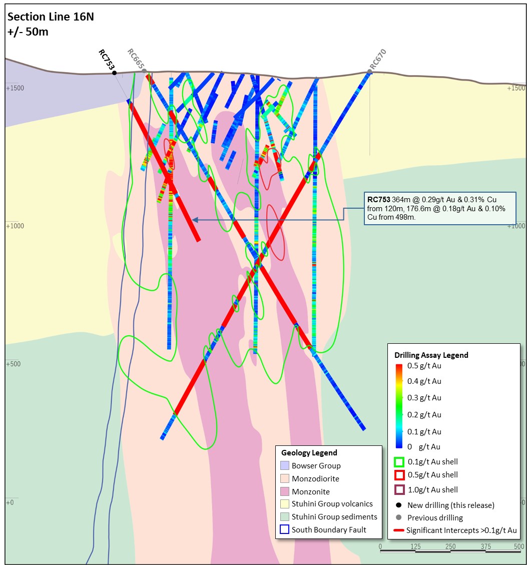
Figure 43. Schematic cross section of RC753 (Section Line 16N - as shown on Figure 39) showing Newcrest and Imperial drill holes and Newcrest intercepts (drill intercepts have been reported in Appendix 2 of this report, and in prior Newcrest exploration releases) 0.1g/t, 0.5g/t Au and 1g/t Au shell projections generated from LeapfrogTM model. Due to window size (+/- 50m) and section orientation (150˚) hole may appear on multiple sections.
To view an enhanced version of Figure 43, please visit:
https://orders.newsfilecorp.com/files/7614/121968_f513433164c07b74_017full.jpg
Appendix 3
Havieron Project (Greatland Gold Plc - Joint Venture Agreement): JORC Table 1
Section 1: Sampling Techniques and Data
| Criteria | Commentary |
| Sampling techniques | Core samples are obtained from core drilling in Proterozoic basement lithologies. PQ-HQ and NQ diameter core was drilled on a 6m run. Core was cut using an automated core-cutter and half core sampled at 1m intervals with breaks for major geological changes. Sampling intervals range from 0.2 - 1.0m. Cover sequences were not sampled. |
| Drilling techniques | Permian Paterson Formation cover sequence was drilled using mud rotary drilling. Depths of cover typically observed to approximately 420m vertically below surface. Steel casing was emplaced to secure the pre-collar. Core drilling was advanced from the base of the cover sequence with PQ3, HQ3 and NQ2 diameter coring configuration. Core from inclined drill holes is oriented on 3m and 6m runs using an electronic core orientation tool (Reflex ACTIII). At the end of each run, the bottom of hole position is marked by the driller, which is later transferred to the whole drill core run length with a bottom of hole reference line. |
| Drill sample recovery | Core recovery is systematically recorded from the commencement of coring to end of hole, by reconciling against driller's depth blocks in each core tray with data recorded in the database. Drillers depth blocks provided the depth, interval of core recovered, and interval of core drilled. Core recoveries were typically 100%, with isolated zones of lower recovery. Cover sequence drilling by the mud-rotary drilling did not yield recoverable samples. |
| Logging | Geological logging recorded qualitative descriptions of lithology, alteration, mineralisation, veining, and structure (for all core drilled - 8,239 m for 13 drill holes, all intersecting mineralisation), including orientation of key geological features. Geotechnical measurements were recorded including Rock Quality Designation (RQD) fracture frequency, solid core recovery and qualitative rock strength measurements. Magnetic susceptibility measurements were recorded every metre. The bulk density of selected drill core intervals was determined at site on whole core samples. All geological and geotechnical logging was conducted at the Havieron site. Digital data logging was captured on diamond drill core intervals only, and all data validated and stored in an acQuire database. All drill cores were photographed, prior to cutting and/or sampling the core. The logging is of sufficient quality to support Mineral Resource estimates. |
| Sub-sampling techniques and sample preparation | Sampling, sample preparation and quality control protocols are considered appropriate for the material being sampled. Core was cut and sampled at the Havieron core processing facility. Half core samples of between 0.2 and 2.0 m were collected in pre-numbered calico bags and grouped in plastic bags for dispatch to the laboratory. Sample weights typically varied from 0.5 to 8kg. Sample sizes are considered appropriate for the style of mineralisation. Drill core samples were freighted by air and road to the laboratory. Sample preparation was conducted at the independent ISO17025 accredited Intertek Laboratory, Perth (Intertek). Samples were dried at 105oC, and crushed to 95% passing 4.75mm, and the split to obtain up to 3kg sub-sample, which was pulverised (using LM5) to produce a pulped product with the minimum standard of 95% passing 106μm. Routine grind size analysis is conducted. Duplicate samples were collected from crush and pulp samples at a rate of 1:20. Duplicate results show an acceptable level of variability for the material sampled and style of mineralisation. Periodic size checks (1:20) for crush and pulp samples and sample weights are provided by the laboratory and recorded in the acQuire database. |
| Quality of assay data and laboratory tests | Assaying of drill core samples was conducted at Intertek. All samples were assayed for 48 elements using a 4-acid digestion followed by ICP-AES/ICP-MS determination (method 4A/MS907), which is considered to provide a total assay for copper. Gold analyses were determined by 50g fire assay with AAS finish (method FA50N/AA), which is considered to provide a total assay for gold. Sampling and assaying quality control procedures consisted of inclusion of certified reference material (CRMs), coarse residue and pulp duplicates with each batch (at least 1:20). Assays of quality control samples were compared with reference samples in acQuire database and verified as acceptable prior to use of data from analysed batches. Laboratory quality control data, including laboratory standards, blanks, duplicates, repeats and grind size results are captured in the acQuire database and assessed for accuracy and precision for recent data. Extended quality control programs including pulp samples submitted to an umpire laboratory and combined with more extensive re-submission programs have been completed. Analysis of the available quality control sample assay results indicates that an acceptable level of accuracy and precision has been achieved and the database contains no analytical data that has been numerically manipulated. The assaying techniques and quality control protocols used are considered appropriate for the data to be used for reporting exploration drilling results. |
| Verification of sampling and assaying | Sampling intervals defined by the geologist are electronically assigned sample identification numbers prior to core cutting. Corresponding sample numbers matching pre-labelled calico bags are assigned to each interval. All sampling and assay information were stored in a secure acQuire database with restricted access. Electronically generated sample submission forms providing the sample identification number accompany each submission to the laboratory. Assay results from the laboratory with corresponding sample identification are loaded directly into the acQuire database. Assessment of reported significant assay intervals was verified by re-logging of diamond drill core intervals and assessment of high resolution core photography. The verification of significant intersections has been completed by company personnel and the Competent Person/Qualified Person. No adjustments are made to assay data, and no twinned holes have been completed. There are no currently known drilling, sampling, recovery, or other factors that could materially affect the accuracy or reliability of the data. |
| Location of data points | Drill collar locations were surveyed using a differential GPS with GNSS with a stated accuracy of +/- 0.5m for all drill holes reported. Drill rig alignment was attained using an electronic azimuth aligner. Downhole survey was collected at 6-12m intervals in the cover sequence, and every 6 to 30m in diamond drill core segments of the drill hole using single shot (Axis Mining Champ Gyro). The single shot surveys have been validated using continuous survey to surface (Axis Mining Champ) along with a selection of drill holes re-surveyed by an external survey contactor using a DeviGyro tool - confirming sufficient accuracy for downhole spatial recording. A LIDAR survey was completed over the project area in Nov 2019 which was used to prepare a DEM / topographic model for the project with a spatial accuracy of +/- 0.1m vertical and +/- 0.3m horizontal. The topography is generally low relief to flat, elevation within the dune corridors in ranges between 250-265m Australian Height Datum (AHD) steepening to the southeast. All collar coordinates are provided in the Geocentric Datum of Australian (GDA20 Zone 51). All relative depth information is reported in AHD +5000m. |
| Data spacing and distribution | Within the South-East Crescent and Breccia zone drill hole spacing ranges from 50 to 100m, to 50 by 50m within the resource extents. Outside the initial resource boundary drill hole spacing ranges from 50 to 200m in lateral extent within the breccia zone over an area of ~2km2. The data spacing is sufficient to establish the degree of geological and grade continuity. Significant assay intercepts remain open. Further drilling is required to determine the extent of currently defined mineralisation. No sample compositing is applied to samples. Drilling intersects mineralisation at various angles. |
| Orientation of data in relation to geological structure | Drill holes exploring the extents of the Havieron mineral system intersect moderately dipping carbonate and siliclastic sedimentary facies, mineralised breccia and sub-vertical intrusive lithologies. Geological modelling has been interpreted from historic and Newcrest drill holes. Variable brecciation, alteration and sulphide mineralisation is observed with a footprint with dimensions of 650m x 350m trending in a north west orientation and over 1000m in vertical extent below cover. The subvertical southeast high grade arcuate crescent sulphide zone has an average thickness of 20m and has been defined over a strike length of up to 550m, and extended to over 700m in vertical extent below cover. Drilling direction is oriented to intersect the steeply dipping high-grade sulphide mineralisation zones at an intersection angle of greater than 40 degrees. The drilled length of reported intersections is typically greater than true width of mineralisation. |
| Sample security | The security of samples is controlled by tracking samples from drill rig to database. Drill core was delivered from the drill rig to the Havieron core yard every shift. On completion of geological and geotechnical logging, core processing was completed by Newcrest personnel at the Havieron facility. High resolution core photography and cutting of drill core was undertaken at the Havieron core processing facilities. Samples were freighted in sealed bags by air and road to the Laboratory, and in the custody of Newcrest representatives. Sample numbers are generated directly from the database. All samples are collected in pre-numbered calico bags. Verification of sample numbers and identification is conducted by the laboratory on receipt of samples, and sample receipt advise issued to Newcrest. Details of all sample movement are recorded in a database table. Dates, Hole ID sample ranges, and the analytical suite requested are recorded with the dispatch of samples to analytical services. Any discrepancies logged at the receipt of samples into the analytical services are validated. |
| Audits or reviews | Internal reviews of core handling, sample preparation and assays laboratories were conducted on a regular basis by both project personnel and owner representatives. In the Competent Person's opinion, the sample preparation, security and analytical procedures are consistent with current industry standards and are entirely appropriate and acceptable for the styles of mineralisation identified and will be appropriate for use in the reporting of exploration results and Mineral Resource estimates. There are no identified drilling, sampling or recovery factors that materially impact the adequacy and reliability of the results of the drilling programme in place at the Havieron Project. |
Section 2: Reporting of Exploration Results
| Criteria | Commentary |
| Mineral tenement and land tenure status | The Havieron Project is entirely contained within mining tenement M45/1287, which is jointly owned by Greatland Pty Ltd and Newcrest Operations Limited. Newcrest has entered into a Joint Venture Agreement (effective 30 November 2020) and Farm-In Agreement (effective 12 March 2019) with Greatland Pty Ltd and Greatland Gold plc. Newcrest is the Manager of the Havieron Project and holds a 70% interest in the Havieron Project with an option to acquire a further 5% joint venture interest at fair value. In December 2021, Newcrest provided notice to Greatland Gold to start the process under the joint venture agreement to seek to agree the option exercise price for the 5% interest. Newcrest and WDLAC are parties to an ILUA which relates to the use of native title land for Newcrest's current operations at Telfer and its activities within a 60-km radius around Telfer and includes its exploration activities at Havieron. The parties have agreed that the ILUA will apply to any future development activities by the Joint Venture Participants (Newcrest and Greatland Gold) at Havieron. The mining tenement M45/1287 wholly replaces the 12 sub-blocks of exploration tenement E45/4701 (former exploration tenement on which the Havieron Project is based) and was granted on 10 September 2020. All obligations with respect to legislative requirements including minimum expenditure are maintained in good standing for prior exploration tenement E45/4701. |
| Exploration done by other parties | Newcrest completed six core holes in the vicinity of the Havieron Project from 1991 to 2003. Greatland Gold completed drill targeting and drilling of nine Reverse Circulation (RC) drill holes with core tails for a total of approximately 6,800m in 2018. Results of drilling programs conducted by Greatland Gold have previously been reported on the Greatland Gold website. Drilling has defined an intrusion-related mineral system with evidence of breccia and massive sulphide-hosted higher-grade gold-copper mineralisation. |
| Geology | The Havieron Project is located within the north-western exposure of the Palaeo-Proterozoic to Neoproterozoic Paterson Orogen (formerly Paterson Province), 45 km east of Telfer. The Yeneena Supergroup hosts the Havieron prospect and consists of a 9km thick sequence of marine sedimentary rocks and is entirely overlain by approximately 420m of Phanerozoic sediments of the Paterson Formation and Quaternary aeolian sediments. Gold and copper mineralisation at Havieron consist of breccia, vein and massive sulphide replacement gold and copper mineralisation typical of intrusion-related and skarn styles of mineralisation. Mineralisation is hosted by metasedimentary rocks (meta-sandstones, meta-siltstones and meta-carbonate) and intrusive rocks of an undetermined age. The main mineral assemblage contains well developed pyrrhotite-chalcopyrite and pyrite sulphide mineral assemblages as breccia and vein infill, and massive sulphide lenses. The main mineralisation event is associated with amphibole-carbonate-biotite-sericite-chlorite wall rock alteration. Drilling has partially defined the extents of mineralisation which are observed over 650m by 350m within an arcuate shaped mineralised zone, and to depths of up to 1400m below surface. |
| Drill hole Information | As provided. |
| Data aggregation methods | Significant assay intercepts are reported as (A) length-weighted averages exceeding 1.0g/t Au greater than or equal to 10m, with a maximum of 5m consecutive internal dilution; and (B) length-weighted averages exceeding 0.2g/t Au for greater than or equal to 20m, with a maximum of 10m consecutive internal dilution, and (C) intervals of >30g/t which are greater or equal to 30 gram metres (Au_ppm x length). No top cuts are applied to intercept calculations. |
| Relationship between mineralisation widths and intercept lengths | Significant assay intervals reported represent apparent widths. Drilling is not always perpendicular to the dip of mineralisation and true widths are less than downhole widths. Estimates of true widths will only be possible when all results are received, and final geological interpretations have been completed. |
| Diagrams | As provided. |
| Balanced reporting | This is the twenty-second release of Exploration Results for this project made by Newcrest. Previous release dates are 25 July 2019, 10 September 2019, 24 October 2019, 2 December 2019, 30 January 2020, 11 March 2020, 30 April 2020, 11 June 2020, 23 July 2020, 10 September 2020, 29 October 2020, 10 December 2020, 28 January 2021, 11 March 2021, 29 April 2021, 10 June 2021, 22 July 2021, 9 September 2021, 28 October 2021, 9 December 2021 and 28 January 2022. Earlier reporting of exploration programs conducted by Newcrest and Greatland Gold have previously been reported. Exploration drilling programs are ongoing and further material results will be reported in subsequent Newcrest releases. |
| Other substantive exploration data | Nil |
| Further work | Growth drilling is planned to extend the December 2020 Inferred Mineral Resource estimate and define the limits of the Havieron mineralised system. |
Drillhole data(1)
Havieron Project, Paterson Province, Western Australia
Reporting Criteria: Intercepts reported are downhole drill width (not true width) Au >0.20ppm (0.2g/t Au) and minimum 20m downhole width with maximum consecutive internal dilution of 10m. Average grades are based on length-weighting of samples grades. Also highlighted are high grade intervals of Au >1.0ppm (1g/t Au) and minimum 10m downhole width with maximum consecutive internal dilution of 5m, and intervals of >30g/t which are greater or equal to 30 gram metres (Au_ppm x length) are tabled. Gold and copper grades are reported to two significant figures, the downhole lengths are rounded to 0.1m which may cause some apparent discrepancies in interval widths. Samples are from core drilling which is PQ, HQ or NQ in diameter. Core is photographed and logged by the geology team before being cut. Half core PQ, HQ and NQ samples are prepared for assay and the remaining material is retained in the core farm for future reference. Each assay batch is submitted with duplicates and standards to monitor laboratory quality. Total depth (end of hole) is rounded to one decimal place for reporting purposes. Collars denoted with a * show partial results, with further significant assays to be reported in subsequent exploration updates.
| Hole ID | Hole Type | Easting (m) | Northing (m) | RL (m) | Total Depth (m) | Azimuth | Dip | From (m) | To (m) | Interval (m) | Au (ppm) | Cu (pct) | Cut off |
| HAD055W4 | MR-DD | 463715 | 7597341 | 263 | 1033 | 47 | -56 | Assays Pending | |||||
| HAD055W5 | MR-DD | 463715 | 7597341 | 263 | 1144.5 | 47 | -56 | Assays Pending | |||||
| HAD085W5 | MR-DD | 463489 | 7598058 | 255 | 1435.1 | 111 | -63 | Geotech drill hole - Not sampled for assays | |||||
| HAD085W6 | MR-DD | 463489 | 7598058 | 255 | 1513.3 | 111 | -63 | 1062 | 1117.6 | 55.6 | 0.82 | 0.04 | 0.2 g/t Au |
| 1134.1 | 1159.7 | 25.7 | 0.39 | 0.04 | 0.2 g/t Au | ||||||||
| 1174.3 | 1238.8 | 64.4 | 2.1 | 0.06 | 0.2 g/t Au | ||||||||
| Incl. | 1199.6 | 1223.4 | 23.7 | 5.3 | 0.10 | 1.0 g/t Au | |||||||
| Incl. | 1208.9 | 1209.2 | 0.3 | 121 | 0.06 | 30 g.m. Au | |||||||
| 1249.9 | 1278 | 28.1 | 0.51 | 0.09 | 0.2 g/t Au | ||||||||
| 1327 | 1379 | 52.0 | 3.0 | 0.09 | 0.2 g/t Au | ||||||||
| Incl. | 1361.1 | 1379 | 17.9 | 7.7 | 0.07 | 1.0 g/t Au | |||||||
| Incl. | 1376.3 | 1376.8 | 0.5 | 70 | 0.03 | 30 g.m. Au | |||||||
| HAD085W7 | MR-DD | 463489 | 7598058 | 255 | 1706.1 | 111 | -63 | 1329.7 | 1359 | 29.3 | 0.53 | 0.09 | 0.2 g/t Au |
| 1534 | 1569.7 | 35.7 | 2.3 | 0.04 | 0.2 g/t Au | ||||||||
| Incl. | 1551 | 1568 | 17.0 | 2.5 | 0.07 | 1.0 g/t Au | |||||||
| HAD089W4 | MR-DD | 464300 | 7597747 | 258 | 1489.9 | 290 | -61 | 570 | 630 | 60 | 0.86 | 0.01 | 0.2 g/t Au |
| Incl. | 570.9 | 571.2 | 0.3 | 101 | 0.00 | 30 g.m. Au | |||||||
| 696 | 732.3 | 36.3 | 0.21 | 0.03 | 0.2 g/t Au | ||||||||
| 770.5 | 793.2 | 22.7 | 0.22 | 0.02 | 0.2 g/t Au | ||||||||
| 878.1 | 942 | 63.9 | 0.57 | 0.07 | 0.2 g/t Au | ||||||||
| 1074 | 1126.7 | 52.7 | 7.1 | 0.04 | 0.2 g/t Au | ||||||||
| Incl. | 1094.9 | 1126.2 | 31.4 | 12 | 0.03 | 1.0 g/t Au | |||||||
| Incl. | 1114.7 | 1116.1 | 1.4 | 40 | 0.04 | 30 g.m. Au | |||||||
| Incl. | 1117.3 | 1122.2 | 4.8 | 35 | 0.01 | 30 g.m. Au | |||||||
| HAD093 | MR-DD | 463522 | 7597783 | 256 | 1525.8 | 77 | -66 | 694.3 | 717 | 22.7 | 0.39 | 0.03 | 0.2 g/t Au |
| 728.6 | 800 | 71.5 | 1.1 | 0.10 | 0.2 g/t Au | ||||||||
| Incl. | 765.2 | 766.1 | 0.8 | 60 | 0.37 | 30 g.m. Au | |||||||
| 886.6 | 1160.2 | 273.6 | 1.1 | 0.14 | 0.2 g/t Au | ||||||||
| Incl. | 993.4 | 1009 | 15.7 | 3.0 | 0.51 | 1.0 g/t Au | |||||||
| Incl. | 1074 | 1087.8 | 13.8 | 2.0 | 0.32 | 1.0 g/t Au | |||||||
| Incl. | 1133.6 | 1157.1 | 23.5 | 2.0 | 0.30 | 1.0 g/t Au | |||||||
| 1263 | 1293.5 | 30.5 | 1.2 | 0.13 | 0.2 g/t Au | ||||||||
| 1306.1 | 1382.8 | 76.7 | 1.9 | 0.07 | 0.2 g/t Au | ||||||||
| Incl. | 1307.2 | 1307.6 | 0.4 | 101 | 0.13 | 30 g.m. Au | |||||||
| Incl. | 1347.8 | 1366 | 18.2 | 3.7 | 0.17 | 1.0 g/t Au | |||||||
| Incl. | 1364.7 | 1365.4 | 0.7 | 56 | 0.25 | 30 g.m. Au | |||||||
| 1392.9 | 1449 | 56.1 | 0.22 | 0.09 | 0.2 g/t Au | ||||||||
| 1460.5 | 1525.8 | 65.3 | 0.44 | 0.10 | 0.2 g/t Au | ||||||||
| HAD104^^ | MR-DD | 463522 | 7597782 | 257 | 1913.6 | 87 | -63 | 642.9 | 677.6 | 34.8 | 1.1 | 0.06 | 0.2 g/t Au |
| 792.1 | 819.9 | 27.8 | 0.29 | 0.06 | 0.2 g/t Au | ||||||||
| 835 | 855.1 | 20.1 | 3.4 | 0.43 | 0.2 g/t Au | ||||||||
| 866.9 | 895.3 | 28.4 | 0.63 | 0.15 | 0.2 g/t Au | ||||||||
| 956.2 | 1092.6 | 136.4 | 0.72 | 0.09 | 0.2 g/t Au | ||||||||
| 1546.5 | 1609 | 62.5 | 5.9 | 0.30 | 0.2 g/t Au | ||||||||
| Incl. | 1554.6 | 1604 | 49.4 | 7.1 | 0.38 | 1.0 g/t Au | |||||||
| 1717 | 1802 | 85.0 | 1.2 | 0.37 | 0.2 g/t Au | ||||||||
| Incl. | 1735.6 | 1746.5 | 10.9 | 3.0 | 0.38 | 1.0 g/t Au | |||||||
| HAD133W6^ | MR-DD | 464072 | 7598317 | 257 | 1639.5 | 171 | -65 | 1367 | 1413 | 46.0 | 0.92 | 0.01 | 0.2 g/t Au |
| 1424.6 | 1597.8 | 173.2 | 1.9 | 0.18 | 0.2 g/t Au | ||||||||
| Incl. | 1425.9 | 1469 | 43.1 | 3.7 | 0.34 | 1.0 g/t Au | |||||||
| Incl. | 1531.8 | 1550 | 18.2 | 2.6 | 0.31 | 1.0 g/t Au | |||||||
| Incl. | 1555.5 | 1567 | 11.5 | 5.4 | 0.04 | 1.0 g/t Au | |||||||
| HAD133W7 | MR-DD | 464072 | 7598317 | 257 | 1692.5 | 171 | -65 | 1462 | 1509 | 47.0 | 0.33 | 0.07 | 0.2 g/t Au |
| 1525.3 | 1548 | 22.7 | 1.2 | 0.08 | 0.2 g/t Au | ||||||||
| 1594.2 | 1615.2 | 21 | 1.2 | 0.07 | 0.2 g/t Au | ||||||||
| Incl | 1601.7 | 1613.4 | 11.7 | 1.7 | 0.09 | 1.0 g/t Au | |||||||
| HAD133W8 | MR-DD | 464072 | 7598317 | 257 | 1696 | 171 | -65 | 1471.9 | 1513.5 | 41.6 | 0.82 | 0.07 | 0.2 g/t Au |
| Incl. | 1474 | 1487 | 13.0 | 1.4 | 0.14 | 1.0 g/t Au | |||||||
| 1533 | 1555 | 22.0 | 0.24 | 0.01 | 0.2 g/t Au | ||||||||
| 1648 | 1672 | 24.0 | 0.39 | 0.02 | 0.2 g/t Au | ||||||||
| HAD133W9 | MR-DD | 464072 | 7598317 | 257 | 1720.1 | 171 | -65 | Assays Pending | |||||
| HAD141W2 | MR-DD | 463361 | 7597505 | 264 | 1757.2 | 27 | -65 | 1314 | 1402 | 88 | 0.98 | 0.03 | 0.2 g/t Au |
| Incl | 1330 | 1343 | 13 | 1.0 | 0.05 | 1.0 g/t Au | |||||||
| 1413 | 1433 | 20 | 0.39 | 0.01 | 0.2 g/t Au | ||||||||
| 1472.3 | 1493 | 20.8 | 0.30 | 0.03 | 0.2 g/t Au | ||||||||
| 1523.5 | 1559.2 | 35.7 | 0.76 | 0.16 | 0.2 g/t Au | ||||||||
| HAD145 | MR-DD | 463201 | 7597816 | 256 | 1824.5 | 75 | -65 | 1300 | 1369 | 69 | 0.72 | 1.1 | 0.2 g/t Au |
| 1383 | 1432.2 | 49.2 | 0.33 | 0.26 | 0.2 g/t Au | ||||||||
| 1590.3 | 1628 | 37.7 | 0.35 | 0.02 | 0.2 g/t Au | ||||||||
| 1654.9 | 1725 | 70.2 | 0.82 | 0.22 | 0.2 g/t Au | ||||||||
| Incl | 1668.9 | 1693.4 | 24.6 | 1.4 | 0.44 | 1.0 g/t Au | |||||||
| 1738.9 | 1763.5 | 24.6 | 1.2 | 0.06 | 0.2 g/t Au | ||||||||
| HAD145W1 | MR-DD | 463201 | 7597817 | 256 | 2041.3 | 75 | -65 | 1633 | 1692.2 | 59.2 | 0.91 | 0.14 | 0.2 g/t Au |
| MR-DD | Incl. | 1639.9 | 1651.6 | 11.7 | 3.5 | 0.53 | 1.0 g/t Au | ||||||
| MR-DD | 1730.4 | 1763.3 | 32.9 | 1.5 | 0.63 | 0.2 g/t Au | |||||||
| MR-DD | Incl. | 1730.4 | 1761 | 30.6 | 1.6 | 0.68 | 1.0 g/t Au | ||||||
| MR-DD | 1827.9 | 1978 | 150.1 | 3.7 | 0.15 | 0.2 g/t Au | |||||||
| MR-DD | Incl. | 1854 | 1896.3 | 42.3 | 8.6 | 0.40 | 1.0 g/t Au | ||||||
| MR-DD | Incl. | 1855.0 | 1857 | 2.0 | 17 | 0.00 | 30 g.m. Au | ||||||
| MR-DD | Incl. | 1859.1 | 1861 | 1.9 | 21 | 0.39 | 30 g.m. Au | ||||||
| MR-DD | Incl. | 1880.3 | 1882 | 1.7 | 23 | 0.44 | 30 g.m. Au | ||||||
| MR-DD | Incl. | 1886 | 1887.1 | 1.1 | 37 | 0.47 | 30 g.m. Au | ||||||
| MR-DD | Incl. | 1907 | 1925 | 18.0 | 2.5 | 0.08 | 1.0 g/t Au | ||||||
| MR-DD | Incl. | 1930.9 | 1954 | 23.2 | 3.1 | 0.01 | 1.0 g/t Au | ||||||
| HAD146W1 | MR-DD | 463451 | 7597873 | 253 | 1189.4 | 69 | -60 | 630.2 | 640.3 | 10.1 | 1.6 | 0.46 | 1.0 g/t Au |
| 651.8 | 672.3 | 20.5 | 0.58 | 0.13 | 0.2 g/t Au | ||||||||
| 804 | 884.6 | 80.6 | 0.37 | 0.44 | 0.2 g/t Au | ||||||||
| HAD152 | MR-DD | 463402 | 7597058 | 254 | 2056.9 | 29 | -62 | 1558.1 | 1558.4 | 0.4 | 112 | 0.00 | 30 g.m. Au |
| MR-DD | 1726 | 1756 | 30.0 | 0.54 | 0.17 | 0.2 g/t Au | |||||||
| MR-DD | 1767 | 1830 | 63.0 | 0.98 | 0.13 | 0.2 g/t Au | |||||||
| MR-DD | Incl. | 1771 | 1783.2 | 12.2 | 1.6 | 0.22 | 1.0 g/t Au | ||||||
| HAD153 | 464786 | 7598418 | 269 | 726 | 201 | -60 | Assays Pending | ||||||
| HAD154 | 463629 | 7597438 | 261 | 1242.5 | 95 | -55 | Assays Pending | ||||||
| HAD155 | 464535 | 7598537 | 257 | 837.4 | 250 | -60 | Assays Pending | ||||||
| ZIP001 | MR-DD | 463055 | 7599814 | 258 | 900.8 | 45 | -70 | No Significant Result | |||||
| ZIP002 | MR-DD | 463606 | 7599618 | 264 | 883 | 45 | -75 | No Significant Result | |||||
#drilling in progress. **partial intercept, assays pending. ^updated intercept. ^^previously reported intercept.

Figure 44. Schematic plan view map showing drill hole locations and significant intercepts reported in this release superimposed on the interpreted geology. Previously reported holes are not shown for the sake of clarity. Note some holes and results appear on multiple sections due to the sections orientation and sections overlap.
To view an enhanced version of Figure 44, please visit:
https://orders.newsfilecorp.com/files/7614/121968_f513433164c07b74_018full.jpg

Figure 45. Schematic cross section of geology and significant new drillhole intercepts (looking northwest, Section Line S1, +/-100m section width, as shown in Figure 44). Due to section window size and orientation holes may appear on multiple sections. This diagram highlights >50gram metres intersections drilled during the period. Reported drill holes are outside of the existing resource.
To view an enhanced version of Figure 45, please visit:
https://orders.newsfilecorp.com/files/7614/121968_f513433164c07b74_019full.jpg

Figure 46. Schematic cross section of geology and significant new drillhole intercepts (looking northeast, Section Line S2, +/-50m section width, as shown in Figure 44). Due to section window size and orientation holes may appear on multiple sections. This diagram highlights >50gram metres intersections drilled during the period. Reported drill holes are outside of the existing resource.
To view an enhanced version of Figure 46, please visit:
https://orders.newsfilecorp.com/files/7614/121968_f513433164c07b74_020full.jpg

Figure 47. Schematic cross section of geology and significant new drillhole intercepts (looking northeast, Section Line S3, +/-50m section width, as shown in Figure 44). Due to section window size and orientation holes may appear on multiple sections. This diagram highlights >100gram metres intersections drilled during the period which are >1g/t Au. Reported drill holes are outside of the existing resource.
To view an enhanced version of Figure 47, please visit:
https://orders.newsfilecorp.com/files/7614/121968_f513433164c07b74_021full.jpg

Figure 48. Schematic cross section of geology and significant new drillhole intercepts (looking northeast, Section Line S4, +/-50m section width, as shown in Figure 44). Due to section window size and orientation holes may appear on multiple sections. This diagram highlights >100gram metres intersections drilled during the quarter which are >1g/t Au. Reported drill holes are outside of the existing resource.
To view an enhanced version of Figure 48, please visit:
https://orders.newsfilecorp.com/files/7614/121968_f513433164c07b74_022full.jpg
Forward Looking Statements
This document includes forward looking statements and forward looking information within the meaning of securities laws of applicable jurisdictions. Forward looking statements can generally be identified by the use of words such as "may", "will", "expect", "intend", "plan", "estimate", "anticipate", "believe", "continue", "objectives", "targets", "outlook" and "guidance", or other similar words and may include, without limitation, statements regarding estimated reserves and resources, expansion, exploration and development activities and the specifications, targets, results, analyses, interpretations, benefits, costs and timing of them; certain plans, strategies, aspirations and objectives of management, anticipated production, study or construction dates, expected costs, cash flow or production outputs and anticipated productive lives of projects and mines. Newcrest continues to distinguish between outlook and guidance. Guidance statements relate to the current financial year. Outlook statements relate to years subsequent to the current financial year.
These forward looking statements involve known and unknown risks, uncertainties and other factors that may cause Newcrest's actual results, performance and achievements or industry results to differ materially from any future results, performance or achievements, or industry results, expressed or implied by these forward-looking statements. Relevant factors may include, but are not limited to, changes in commodity prices, foreign exchange fluctuations and general economic conditions, increased costs and demand for production inputs, the speculative nature of exploration and project development, including the risks of obtaining necessary licences and permits and diminishing quantities or grades of reserves, political and social risks, changes to the regulatory framework within which Newcrest operates or may in the future operate, environmental conditions including extreme weather conditions, recruitment and retention of personnel, industrial relations issues and litigation. For further information as to the risks which may impact on Newcrest's results and performance, please see the risk factors included in the Operating and Financial Review included in the Appendix 4E and Financial Report for the year ended 30 June 2021 and the Annual Information Form dated 6 December 2021 which are available to view at www.asx.com.au under the code "NCM" and on Newcrest's SEDAR profile.
Forward looking statements are based on Newcrest's good faith assumptions as to the financial, market, regulatory and other relevant environments that will exist and affect Newcrest's business and operations in the future. Newcrest does not give any assurance that the assumptions will prove to be correct. There may be other factors that could cause actual results or events not to be as anticipated, and many events are beyond the reasonable control of Newcrest. Readers are cautioned not to place undue reliance on forward looking statements, particularly in the current economic climate with the significant volatility, uncertainty and disruption caused by the COVID-19 pandemic. Forward looking statements in this document speak only at the date of issue. Except as required by applicable laws or regulations, Newcrest does not undertake any obligation to publicly update or revise any of the forward looking statements or to advise of any change in assumptions on which any such statement is based.
Ore Reserves and Mineral Resources Reporting Requirements
As an Australian Company with securities listed on the Australian Securities Exchange (ASX), Newcrest is subject to Australian disclosure requirements and standards, including the requirements of the Corporations Act 2001 and the ASX. Investors should note that it is a requirement of the ASX listing rules that the reporting of Ore Reserves and Mineral Resources in Australia is in accordance with the 2012 Edition of the Australasian Code for Reporting of Exploration Results, Mineral Resources and Ore Reserves (the JORC Code) and that Newcrest's Ore Reserve and Mineral Resource estimates comply with the JORC Code.
Newcrest is also subject to certain Canadian disclosure requirements and standards, as a result of its listing on the Toronto Stock Exchange (TSX), including the requirements of National Instrument 43-101 (NI 43-101). Investors should note that it is a requirement of Canadian securities law that the reporting of Mineral Reserves and Mineral Resources in Canada and the disclosure of scientific and technical information concerning a mineral project on a property material to Newcrest comply with NI 43-101.
Newcrest's material properties are currently Cadia, Lihir, Red Chris and Wafi-Golpu. Copies of the NI 43-101 Reports for Cadia, Lihir and Wafi-Golpu, which were released on 14 October 2020, and Red Chris, which was released on 30 November 2021, are available at www.newcrest.com.au and on Newcrest's SEDAR profile. Brucejack is expected to be a material property to Newcrest. A NI43-101 Report on Brucejack dated 9 March 2020 was filed by Pretium on SEDAR (www.sedar.com).
Competent Person's Statement
The information in this document that relates to Exploration Targets, Exploration Results, and related scientific and technical information, is based on and fairly represents information compiled by Mr F. MacCorquodale. Mr MacCorquodale is the General Manager - Greenfields Exploration and a full-time employee of Newcrest Mining Limited. He is a shareholder in Newcrest Mining Limited and is entitled to participate in Newcrest's executive equity long term incentive plan, details of which are included in Newcrest's 2020 Remuneration Report. He is a Member of the Australian Institute of Geoscientists. Mr MacCorquodale has sufficient experience which is relevant to the styles of mineralisation and types of deposits under consideration and to the activity which he is undertaking to qualify as a Competent Person as defined in the JORC Code and as a Qualified Person under NI 43-101. Mr MacCorquodale approves the disclosure of scientific and technical information contained in this document and consents to the inclusion of material of the matters based on his information in the form and context in which it appears.
Authorised by the Newcrest Disclosure Committee
For further information please contact
Investor Enquires
Tom Dixon
+61 3 9522 5570
+61 450 541 389
Tom.Dixon@newcrest.com.au
Rebecca Lay
+61 3 9522 5298
+61 438 355 511
Rebecca.Lay@newcrest.com.au
North American Investor Enquiries
Ryan Skaleskog
+1 866 396 0242
+61 403 435 222
Ryan.Skaleskog@newcrest.com.au
Media Enquiries
Tim Salathiel
+61 3 9522 4263
+61 407 885 272
Tim.Salathiel@newcrest.com.au
This information is available on our website at www.newcrest.com
1 # drilling in progress ** partial intercept, assays pending ^ updated intercept or ^^ previously reported.
2 # drilling in progress ** partial intercept, assays pending ^ updated intercept or ^^ previously reported.
3 # drilling in progress ** partial intercept, assays pending ^ updated intercept or ^^ previously reported.
4 Newcrest can elect to extend this period by up to 2 years.
To view the source version of this press release, please visit https://www.newsfilecorp.com/release/121968
Source: Newcrest Mining Limited