
Apr 02, 2024
In the digital realm, swamped with media and news stories, standing out is a challenge. As of December 2023, the New York Times alone saw...
Exploration Update 9 December 2021
Red Chris and Havieron continue to deliver excellent drilling results
At Red Chris, drilling continues to expand the footprint and continuity of the higher grade mineralisation of East Ridge.
RC745 returned 366m @ 0.45g/t Au & 0.57% Cu from 728m, including 36m @ 1.4g/t Au & 1.2% Cu from 960m. This hole is located 100m above RC735 and extended the higher grade mineralisation a further 100m to the east.
RC739 returned 390m @ 0.63g/t Au & 0.48% Cu from 1,088m, including 44m @ 2.0g/t Au & 1.3% Cu from 1,402m. This hole is located 100m east of RC727 (previously reported).
The mineralisation at East Ridge is open to the East and at depth with ongoing drilling to define the extents.
At Havieron, infill drilling within the South East Crescent Zone Inferred Mineral Resource extent was finalised during the period. Currently all drill rigs are focused on growth programs targeting the extensions of mineralisation outside of the initial Inferred Mineral Resource.
At the South East Crescent Zone the infill drilling completed validates both geological and grade continuity.
Growth drilling more than 250m below the Mineral Resource extents continue to return high grade results including HAD086W3^^** which returned 44.7m^^ @ 7.1g/t Au & 0.17% Cu from 1,412m including 20.2m^^ @ 15g/t Au & 0.29% Cu from 1,421m.
Drill testing of new additional geophysical targets 2km outside of the Havieron system has commenced.
Melbourne, Australia--(Newsfile Corp. - December 8, 2021) - Newcrest Mining Limited (ASX: NCM) (TSX: NCM) (PNGX: NCM) Newcrest Managing Director and Chief Executive Officer, Sandeep Biswas, said, "Our latest drilling results continue to demonstrate the quality of our Red Chris and Havieron assets. Drilling results at our East Ridge discovery were particularly encouraging with further expansion of the mineralisation footprint to the east. The high-grade mineralisation remains open to the east and at depth which provides exciting potential for the resource base at Red Chris to grow over time."
"At Havieron, our exploration is now totally focused on growth which has continued to demonstrate potential for resource additions outside of the existing Inferred Mineral Resource limits. We have eight operating rigs exploring the high-grade targets in and around the main Havieron deposit including the high grade depth extents of the South East Crescent," said Mr Biswas.
Red Chris - Significant results since the September 2021 Quarterly Exploration Report(1):
Havieron - Significant results since the September 2021 Quarterly Exploration Report(1):
Red Chris, British Columbia, Canada(2)
Red Chris is a joint venture between Newcrest (70%) and Imperial Metals Corporation (30%) which is operated by Newcrest.
The Brownfields Exploration program is focused on the discovery of additional zones of higher grade mineralisation within the Red Chris porphyry corridor, including targets outside of Newcrest's initial Mineral Resource estimate. During the period, there were up to eight diamond drill rigs in operation. A further 14,832m of drilling has been completed from 15 drill holes, with all drill holes intersecting mineralisation (except seven drill holes which were dedicated geotechnical holes). This contributed to a total of 210,906m of drilling from 176 drill holes since Newcrest acquired its interest in the joint venture in August 2019.
At East Ridge, located adjacent to the East Zone, drilling is ongoing with 18 holes completed and 4 in progress. The follow up drilling is being completed on a nominal 100m x 100m grid to determine the footprint of the mineralisation and demonstrate the continuity of the higher grade mineralisation.
Results for the reporting period include:
Drilling continues to expand the footprint and continuity of the higher grade mineralisation and has demonstrated continuity of the East Ridge zone (>0.4g/t Au and >0.4% Cu) over dimensions of 600m high, 500m long and 125m wide, with the higher grade (>0.8g/t Au and >0.8% Cu) over 500m high, 300m long and 100m wide. The mineralisation remains open to the East and at depth.
East Ridge is located 300m east of East Zone and is outside of Newcrest's initial Mineral Resource estimate, supporting the potential for resource growth over time. Follow-up drilling is in progress to further define the extent and continuity of this high grade mineralisation.
Approximately 50,000m of growth-related drilling is planned this calendar year 2021 from eight drill rigs.
Refer to Appendix 1 for additional information, and the Drillhole data table for all results reported during the period.

Figure 1. Schematic plan view map of the Red Chris porphyry corridor spanning East Ridge, East Zone, Main Zone and Gully Zone showing drill hole locations (Newcrest & Imperial) and significant Newcrest intercepts (drill intercepts have been reported in Appendix 1 of this report, and in prior Newcrest exploration releases) 0.3g/t Au, 1g/t Au, 0.3% Cu and 1% Cu shell projections generated from a Leapfrog model.
To view an enhanced version of Figure 1, please visit:
https://orders.newsfilecorp.com/files/7614/107125_0faf83f674be59d7_003full.jpg

Figure 2. Long section view (looking North West) of the Red Chris porphyry corridor showing drill hole locations and gold distribution.
To view an enhanced version of Figure 2, please visit:
https://orders.newsfilecorp.com/files/7614/107125_0faf83f674be59d7_004full.jpg
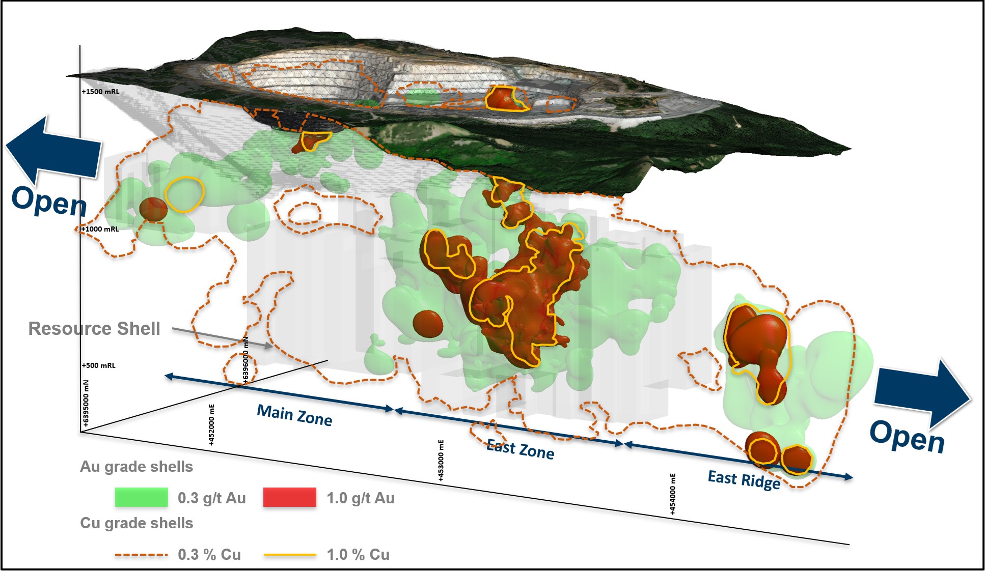
Figure 3. Oblique schematic section view of the Red Chris porphyry corridor showing gold distribution. 0.3 g/t Au,1 g/t Au, 0.3% Cu and 1% Cu shell projections generated from the LeapfrogTM model.
To view an enhanced version of Figure 3, please visit:
https://orders.newsfilecorp.com/files/7614/107125_0faf83f674be59d7_005full.jpg
Havieron Project, Western Australia, Australia(3)
The Havieron Project is operated by Newcrest under a Joint Venture Agreement with Greatland Gold. Following the delivery of the Pre-Feasibility Study on 12 October 2021, Newcrest is now entitled to an additional 10% interest in the Havieron Project, which would bring Newcrest's cumulative interest to 70%. Newcrest has an option to acquire an additional 5% Joint Venture interest for fair market value, exercisable during the 12 months from 12 December 2021. The Joint Venture Agreement includes tolling principles reflecting the intention of the parties that, subject to a successful exploration program, Feasibility Study and a positive decision to mine, the resulting joint venture mineralised material will be processed at Telfer.
The Havieron Project is centred on a deep magnetic anomaly located 45km east of Telfer in the Paterson Province. The deposit is overlain by more than 420m of post mineral Permian cover. A total of 8,932m of new drilling has been completed from 12 drill holes during the interim period. This report is covering results from 24 holes (including 3 holes completed this period, and 21 holes from the September quarter). Of the reported holes, 19 holes returned significant assay intercepts in excess of 50 gram metres Au (Au ppm x length m). A total of 219,561m of drilling from 266 drill holes has been completed since Newcrest commenced exploration activity (excluding holes in progress, abandoned holes, or drill holes which have not been sampled).
Drilling in the reporting period was focused on potential resource growth at the South East Crescent, Northern Breccia and Eastern Breccia, and infill drilling the South East Crescent Zone to support the potential conversion of the Inferred Resource to Indicated Resource. Drilling included:
Infill drilling within the South East Crescent Zone Inferred Mineral Resource extents were finalised during the period, with 3 further drill holes completed, and assays reported for twenty drill holes (including 17 drill holes from the prior period). Assay results from one final drill hole is pending. This drilling is designed to infill the South East Crescent Inferred Mineral Resource volume to 50m x 50m spacing to support the potential upgrade of a significant portion of the Inferred Mineral Resource to an Indicated Mineral Resource. Results received from infill drilling support the modelled grade and thickness within the South East Crescent Zone Mineral Resource extents.
Results include:
All drill programs have now returned to growth targets. Growth drilling continues to show potential for resource additions outside of the existing Inferred Mineral Resource limits, including:
At the South East Crescent, growth drilling targeting higher grade mineralisation at depth on 75m by 75m spacing has extended the mineralisation 250m below the initial Inferred Mineral Resource estimate. New results from four drill holes have been received.
Results include:
Further to results reported in the last period, HAD086W3 returned assays for the lower portion of the drill hole and reported a second high grade zone 200m below the existing resource of 48m @ 2.2g/t Au & 0.15% Cu from 1,525m, including 26.9m @ 3.7g/t Au & 0.26% Cu from 1,538.1m. A mineralised zone 100m below HAD086W3 was returned in HAD086W4, which confirmed extension of crescent mineralisation over 250m from the Inferred Mineral Resource extents. These results are approximately 100m to the north-west of prior high grade hole HAD133W1 and continue to support extensions of the Crescent Zone at depth. Drilling continues to assess the depth extents of the South East Crescent which now has a vertical extent of over 900m.
Drilling to test geophysical targets outside of the known Havieron system have commenced at Havieron North, and Zipa. The Havieron North target is located 2 km north of Havieron and is sited on a magnetic high anomaly. Zipa, is located approximately 1 km to the west of Havieron North and is centred on a prominent gravity high anomaly. The assay results for initial drilling into these targets is pending. Drilling continues to test these and other targets outside of the main Havieron deposit.
Eight drill rigs are currently operational testing extensions of the South East Crescent Zone below 4,200mRL, extension and definition of the Northern and Eastern Breccia, and associated internal higher-grade zones to support potential expansion of the existing Inferred Mineral Resource. Additionally, drilling is continuing to target geophysical targets outside of the main Havieron system.
Refer to Appendix 2 for additional information and Drillhole data table for all results reported during the period.

Figure 4. 3D Plan view schematic showing the spatial association of the South East Crescent, Northern Breccia, North West Pod and Eastern Breccia targets in relation to the Inferred Resource extents. Also highlighted are previously reported intercepts >100 gram metres (Au ppm x length) that have been intersected outside of the Inferred Mineral Resource.
To view an enhanced version of Figure 4, please visit:
https://orders.newsfilecorp.com/files/7614/107125_0faf83f674be59d7_006full.jpg

Figure 5. 3D section view schematic across section line A-A' on Figure 4, highlighting selected South East Crescent growth intercepts below the current Inferred Resource.
To view an enhanced version of Figure 5, please visit:
https://orders.newsfilecorp.com/files/7614/107125_0faf83f674be59d7_007full.jpg

Figure 6. Plan view schematic of a horizontal slice at 4700mRL through the Crescent Sulphide Zone and Breccia-hosted Zones, showing the extents of the 0.5 and 1.0 g/t Au LeapfrogTM grade shells with highlighted newly reported intercepts for this period. This diagram highlights >100gram metres intersections drilled during the period which are >1g/t Au, refer to inset diagram for relationship to all Havieron drilling.
To view an enhanced version of Figure 6, please visit:
https://orders.newsfilecorp.com/files/7614/107125_0faf83f674be59d7_008full.jpg
Wilki Project, Western Australia, Australia
The Wilki Project is an exploration farm-in and joint venture with Antipa Minerals Limited (Antipa). The project area covers a strategic landholding of ~2,200km2 surrounding the Telfer operation and is adjacent to the Havieron Project. Newcrest entered into this exploration farm-in and joint venture agreement with Antipa on 11 March 2020. Newcrest currently has a 9.9% shareholding in Antipa.
Newcrest has elected to proceed to the next stage (Stage 1) of the farm-in agreement following completion of the initial exploration expenditure commitment (A$6 million). Newcrest has the potential to earn a 51% joint venture interest in the Wilki Project through expenditure of a further A$10 million by March 2025 during Stage 14.
Scout diamond drilling of the Tyama Prospect was completed during the period. Assay results are pending. In addition, ground electromagnetic surveys were completed over priority target areas during the period. Processing and interpretation have commenced.
Juri Joint Venture, Western Australia, Australia
The Juri Joint Venture is a farm-in and joint venture agreement with Greatland Gold with respect to its Black Hills and Paterson Range East projects, located within the Paterson Province approximately 50km from the Telfer operation and in proximity to the Havieron Project. The joint venture covers an area of approximately 248km2.
Newcrest has met the Stage 1 exploration expenditure (A$3 million) and now holds a 51% interest in the Juri Joint Venture. Under the terms of the agreement, Newcrest has the potential to earn an additional 24% joint venture interest (for a cumulative 75% joint venture interest) through expenditure of a further A$17 million over three years during Stage 25.
Follow up ground electromagnetic surveys over additional targets at both Paterson Range East and Black Hills were completed during the period.
Tennant East, Northern Territory, Australia
Work programs focussing on undercover targets at the Tennant East project (located 200km east of Tennant Creek) have been completed over the initial six target areas. Induced polarisation (IP) data processing is currently progressing. Scout drilling is planned to be completed on defined coincident gravity, magnetic and IP targets in calendar year 2022.
Nevada, USA
Drill activities were completed at the Jarbidge project in north-eastern Nevada during the period with testing focused on low sulfidation epithermal vein targets. Assay results are pending, but visually the targets are downgraded. As a result, Newcrest has provided notice of termination with respect to several of the option agreements underlying the Jarbidge project with the decision to retain any remaining option agreements pending the receipt of outstanding assay results and conducting required reclamation activities.
Drilling at the Fortuity89 project in south-western Nevada is scheduled to begin in the March 2022 quarter pending drill rig availability.
Central Andes, Northern Chile
Drilling has commenced on the Atlas project which is part of the Gorbea Joint Venture operated by Newcrest.
Northern Andes, Ecuador
Drilling has commenced at the Gamora Project. This work is being undertaken by Newcrest as operator under an earn-in agreement with Lundin Gold Inc. pursuant to which Newcrest can earn up to a 50% interest in eight exploration concessions.
Appendix 1
Red Chris (70% Newcrest): JORC Table 1
Section 1: Sampling Techniques and Data
| Criteria | Commentary |
| Sampling techniques | Core samples are obtained from core drilling. HQ and NQ diameter diamond core was drilled on a 3, 4.5m or 6m run. Core was cut using an automatic core-cutter and half core sampled at 2m intervals. Cover sequences were not sampled. |
| Drilling techniques | Core drilling was advanced with HQ3, HQ, NQ3 and NQ diameter coring configuration. Core from inclined drill holes are oriented on 3, 4.5m or 6m runs using an electronic core orientation tool (Reflex ACTIII). At the end of each run, the bottom of hole position is marked by the driller, which is later transferred to the whole drill core run length with a bottom of hole reference line. |
| Drill sample recovery | Core recovery is systematically recorded from the commencement of coring to end of hole, by reconciling against driller's depth blocks in each core tray with data recorded in the database. Drillers depth blocks provided the depth, interval of core recovered, and interval of core drilled. Core recoveries were typically 100%, with isolated zones of lower recovery. |
| Logging | Geological logging recorded qualitative descriptions of lithology, alteration, mineralisation, veining, and structure (for all core drilled - 14,832m in 15 holes- all holes intersected mineralisation except for 7 dedicated geotechnical holes, including orientation of key geological features. Geotechnical measurements were recorded including Rock Quality Designation (RQD) fracture frequency, solid core recovery and qualitative rock strength measurements. Magnetic susceptibility measurements were recorded every metre. All geological and geotechnical logging was conducted at the Red Chris Mine. Digital data logging was captured, validated and stored in an acQuire database. All drill cores were photographed, prior to cutting and/or sampling the core. |
| Sub-sampling techniques and sample preparation | Sampling, sample preparation and quality control protocols are considered appropriate for the material being sampled. Core was cut and sampled at the Red Chris Mine core processing facility. Half core samples were collected in plastic bags together with pre-numbered sample tags and grouped in wood crates for dispatch to the laboratory. Sample weights typically varied from 5 to 10kg. Sample sizes are considered appropriate for the style of mineralisation. Drill core samples were freighted by road to the laboratory. Sample preparation was conducted at the independent ISO 9001 certified and ISO 17025 accredited Bureau Veritas Commodities Canada Ltd Laboratory, Vancouver (Bureau Veritas). Samples were dried at 650C, and crushed to 95% passing 4.75 mm, and the split to obtain up to 1kg sub-sample, which was pulverised (using LM2) to produce a pulped product with the minimum standard of 95% passing 106μm. Duplicate samples were collected from crush and pulp samples at a rate of 1:20. Duplicate results show an acceptable level of variability for the material sampled and style of mineralisation. Periodic size checks (1:20) for crush and pulp samples and sample weights are provided by the laboratory and recorded in the acQuire database. |
| Quality of assay data and laboratory tests | Assaying of drill core samples was conducted at Bureau Veritas. All samples were assayed for 59 elements using a 4-acid digestion followed by ICP-AES/ICP-MS determination (method MA250). Gold analyses were determined by 50g fire assay with ICP-ES finish (method FA350). Carbon and Sulphur were determined by Leco (method TC000) and mercury using aqua regia digestion followed by ICP-ES/MS determination (method AQ200). Sampling and assaying quality control procedures consisted of inclusion of certified reference material (CRMs), coarse residue and pulp duplicates with each batch (at least 1:20). Assays of quality control samples were compared with reference samples in the acQuire database and verified as acceptable prior to use of data from analysed batches. Laboratory quality control data, including laboratory standards, blanks, duplicates, repeats and grind size results are captured in acQuire database and assessed for accuracy and precision for recent data. Due to the limited extent of the drilling program to date, extended quality control programs are yet to be undertaken, whereby pulped samples will be submitted to an umpire laboratory and combined with more extensive re-submission programs. Analysis of the available quality control sample assay results indicates that an acceptable level of accuracy and precision has been achieved and the database contains no analytical data that has been numerically manipulated. The assaying techniques and quality control protocols used are considered appropriate for the data to be used for reporting exploration drilling results. |
| Verification of sampling and assaying | Sampling intervals defined by the geologist are electronically assigned sample identification numbers prior to core cutting. Corresponding sample numbers matching pre-labelled sample tags are assigned to each interval. All sampling and assay information were stored in a secure acQuire database with restricted access. Electronically generated sample submission forms providing the sample identification number accompany each submission to the laboratory. Assay results from the laboratory with corresponding sample identification are loaded directly into the acQuire database. Assessment of reported significant assay intervals was verified by re-logging of drill core intervals and assessment of high resolution core photography. The verification of significant intersections has been completed by company personnel and the Competent Person/Qualified Person. No adjustments are made to assay data, and no twinned holes have been completed. Drilling intersects mineralisation at various angles. There are no currently known drilling, sampling, recovery, or other factors that could materially affect the accuracy or reliability of the data. |
| Location of data points | Drill collar locations were surveyed using a RTK GPS with GNSS with a stated accuracy of +/- 0.025m. Drill rig alignment was attained using an electronic azimuth aligner (Reflex TN14 GYROCOMPASS). Downhole survey was collected at 9 to 30m intervals of the drill hole using single shot survey (Reflex EZ-SHOT). At the end of hole, all holes have been surveyed using a continuous gyro survey to surface (Reflex EZ-GYRO). Topographic control is established from PhotoSat topographic data and derived digital elevation model. The topography is generally low relief to flat, with an average elevation of 1500 m, with several deep creek gullies. All collar coordinates are provided in the North American Datum (NAD83 Zone 9). |
| Data spacing and distribution | The drill hole spacing ranges from 100 - 200m in lateral extent within an area of 1.5km2 at the East Ridge, 1.5km2 at the East Zone, 1.5km2 at the Main Zone and 1.5km2 at the Gully Zone. No sample compositing is applied to samples. |
| Orientation of data in relation to geological structure | Drilling of reported drill holes RC735, R739, RC745, RC746 and RC747 are oriented perpendicular to the intrusive complex. The intrusive complex has an east-northeast orientation, with drilling established on a north-northwest orientation. Drill holes exploring the extents of the East Ridge, East Zone, Main Zone and Gully Zone mineral system intersected moderately dipping volcanic and sedimentary units cut by sub-vertical intrusive lithologies. Steeply dipping mineralised zones with an east-northeast orientation have been interpreted from historic and Newcrest drill holes. |
| Sample security | The security of samples is controlled by tracking samples from drill rig to database. Drill core was delivered from the drill rig to the Red Chris Mine core yard every shift. Geological and geotechnical logging, high resolution core photography and cutting of drill core was undertaken at the Red Chris core processing facility. Samples were freighted in sealed bags with security tags by road to the laboratory, and in the custody of Newcrest representatives. Sample numbers are generated from pre-labelled sample tags. All samples are collected in pre-numbered plastic bags. Sample tags are inserted into prenumbered plastic bags together with the sample. Verification of sample numbers and identification is conducted by the laboratory on receipt of samples, and sample receipt advice issued to Newcrest. Details of all sample movement are recorded in a database table. Dates, Hole ID sample ranges, and the analytical suite requested are recorded with the dispatch of samples to the laboratory analytical services. Any discrepancies logged at the receipt of samples into the laboratory analytical services are validated. |
| Audits or reviews | Due to the limited duration of the program, no external audits or reviews have been undertaken. Internal verification and audit of Newcrest exploration procedures and databases are periodically undertaken. |
Section 2: Reporting of Exploration Results
| Criteria | Commentary |
| Mineral tenement and land tenure status | Red Chris comprises 77 mineral tenures including five mining leases and is a joint venture between subsidiaries of Newcrest Mining Limited (70%) and Imperial Metals Corporation (30%). Newcrest Red Chris Mining Limited is the operator of Red Chris. Newcrest Red Chris Mining Limited and the Tahltan Nation (as represented by the Tahltan Central Government, the Tahltan Band and Iskut First Nation) signed an amended and restated updated Impact, Benefit and Co-Management Agreement (IBCA) covering Red Chris on 15 August 2019. All obligations with respect to legislative requirements including minimum expenditure are maintained in good standing. |
| Exploration done by other parties | Conwest Exploration Limited, Great Plains Development Co. of Canada, Silver Standard Mines Ltd, Texasgulf Canada Ltd. (formerly Ecstall Mining Limited), American Bullion Minerals Ltd and bcMetals Corporation conducted exploration in the areas between 1956 and 2006. Imperial Metals Corporation acquired the project in 2007 and completed deeper drilling at the East and Main Zones between 2007 and 2012. |
| Geology | The Red Chris Project is located in the Stikine terrane of north-western British Columbia, 80 km south of the town of Dease Lake. Late Triassic sedimentary and volcanic rocks of the Stuhini Group host a series of Late Triassic to Early Jurassic 204−198 Ma) diorite to quartz monzonite stocks and dykes. Gold and copper mineralisation at Red Chris consists of vein, disseminated and breccia sulphide typical of porphyry-style mineralisation. Mineralisation is hosted by diorite to quartz monzonite stocks and dykes. The main mineral assemblage contains well developed pyrite-chalcopyrite-bornite sulphide mineral assemblages as vein and breccia infill, and disseminations. The main mineralisation event is associated with biotite and potassium feldspar-magnetite wall rock alteration. |
| Drill hole information | As provided. |
| Data aggregation methods | Significant assay intercepts are reported as (A) length-weighted averages exceeding 0.1g/t Au greater than or equal to 20m, with less than 10m of consecutive internal dilution; and (B) length-weighted averages exceeding 0.5g/t Au for greater than or equal to 10m, with less than 10m of consecutive internal dilution; and (C) length-weighted averages exceeding 1g/t Au for greater than or equal to 10m, with less than 10m of consecutive internal dilution; (D) length-weighted averages exceeding 5g/t Au greater than or equal to 10m, with less than 10m of consecutive internal dilution; and (E) length-weighted averages exceeding 10g/t Au for greater than or equal to 10m, with less than 10m of consecutive internal dilution. No top cuts are applied to intercept calculations. |
| Relationship between mineralisation widths and intercept lengths | Significant assay intervals reported represent apparent widths. Insufficient geological information is available to confirm the geological model and true width of significant assay intervals. |
| Diagrams | As provided. |
| Balanced reporting | This is the sixteenth release of Exploration Results for this project made by Newcrest. Previous release dates are 30 January 2020, 11 March 2020, 30 April 2020, 11 June 2020, 23 July 2020, 10 September 2020, 29 October 2020, 10 December 2020, 28 January 2021, 11 March 2021, 29 April 2021, 10 June 2021, 22 July 2021 9 September 2021, and 28 October 2021. Earlier reporting of exploration programs conducted by Newcrest and Imperial Metals Corporation have previously been reported. Exploration drilling programs are ongoing and further material results will be reported in subsequent Newcrest releases. |
| Other substantive exploration data | Nil. |
| Further work | Further drilling is planned to define the extents of the East Ridge, East Zone and Main Zone. |
Drillhole data(1)
Red Chris Project, British Columbia, Canada
Reporting Criteria: Intercepts reported are downhole drill width (not true width) Au >0.1ppm (0.1g/t Au) and minimum 20m downhole width with maximum consecutive internal dilution of 10m. Also highlighted are high grade intervals of Au >0.5ppm (0.5g/t Au), Au >1ppm (1g/t Au), Au > 5ppm (5g/t Au), Au >10ppm (10g/t Au) and minimum 10m downhole width with maximum consecutive internal dilution of 10m. Gold grades are reported to two significant figures. Samples are from core drilling which is HQ or NQ in diameter. Core is photographed and logged by the geology team before being cut. Half core HQ and NQ samples are prepared for assay and the remaining material is retained in the core farm for future reference. Each assay batch is submitted with duplicates and standards to monitor laboratory quality. Total depth (end of hole) is rounded to one decimal place for reporting purposes.
| Hole ID | Hole Type | Easting (m) | Northing (m) | RL (m) | Total Depth (m) | Azimuth | Dip | From (m) | To (m) | Interval (m) | Au (ppm) | Cu (pct) | Cut off |
| (GRID) | |||||||||||||
| RC735 | DD | 453568 | 6396656 | 1392 | 1501.8 | 147 | -58 | 888 | 1128 | 240 | 0.49 | 0.53 | 0.1 |
| incl. | 972 | 986 | 14 | 0.52 | 0.77 | 0.5 | |||||||
| incl. | 1012 | 1114 | 102 | 0.82 | 0.59 | 0.5 | |||||||
| incl. | 1068 | 1092 | 24 | 1.4 | 0.68 | 1 | |||||||
| 1148 | 1170 | 22 | 0.33 | 0.45 | 0.1 | ||||||||
| 1216 | 1296 | 80 | 0.25 | 0.35 | 0.1 | ||||||||
| RC739 | DD | 453383 | 6396811 | 1451 | 1681.5 | 146 | -57 | 1088 | 1478 | 390 | 0.63 | 0.48 | 0.1 |
| incl. | 1244 | 1282 | 38 | 1.8 | 0.71 | 0.5 | |||||||
| incl. | 1246 | 1268 | 22 | 2.6 | 1.0 | 1 | |||||||
| incl. | 1302 | 1372 | 70 | 0.68 | 0.49 | 0.5 | |||||||
| incl. | 1402 | 1446 | 44 | 2.0 | 1.3 | 0.5 | |||||||
| incl. | 1402 | 1446 | 44 | 2.0 | 1.3 | 1 | |||||||
| RC740 | DD | 453407 | 6397178 | 1465 | 2142.2 | 146 | -45 | Assays Pending | |||||
| RC745 | DD | 453624 | 6396544 | 1403 | 1364.3 | 145 | -60 | 728 | 1094 | 366 | 0.45 | 0.57 | 0.1 |
| incl. | 880 | 944 | 64 | 0.64 | 0.53 | 0.5 | |||||||
| incl. | 958 | 1016 | 58 | 1.1 | 1.0 | 0.5 | |||||||
| incl. | 960 | 996 | 36 | 1.4 | 1.2 | 1 | |||||||
| RC746 | DD | 453207 | 6396497 | 1432 | 1043.1 | 150 | 48 | 110 | 130 | 20 | 0.11 | 0.01 | 0.1 |
| 552 | 652 | 100 | 0.22 | 0.22 | 0.1 | ||||||||
| 664 | 716 | 52 | 0.11 | 0.17 | 0.1 | ||||||||
| 734 | 766 | 32 | 0.11 | 0.19 | 0.1 | ||||||||
| 956 | 990 | 34 | 0.15 | 0.02 | 0.1 | ||||||||
| RC747 | DD | 453548 | 6396527 | 1403 | 1268.2 | 149 | -59 | 706 | 1012 | 306 | 0.28 | 0.39 | 0.1 |
| incl. | 880 | 926 | 46 | 0.77 | 0.86 | 0.5 | |||||||
| incl. | 896 | 916 | 20 | 1.1 | 1.2 | 1 | |||||||
| 1094 | 1120 | 26 | 0.13 | 0.19 | 0.1 | ||||||||
| RC748 | DD | 453240 | 6396830 | 1461 | 1790.2 | 145 | -60 | Assays Pending | |||||
| RC750W | DD | 453340 | 6396870 | 1456 | 1843.2 | 146 | -58 | Assays Pending | |||||
| RC751 | DD | 452126 | 6396252 | 1520 | 1200.6 | 123 | -63 | Geotechnical Hole - Not Sampled | |||||
| RC754 | DD | 453584 | 6396467 | 1409 | 1034.1 | 150 | -57 | Assays Pending | |||||
| RC755 | DD | 452579 | 6396361 | 1491 | 1218 | 134 | -76 | Geotechnical Hole - Not Sampled | |||||
| RC765 | DD | 451551 | 6395471 | 1522 | 1059.1 | 156 | -65 | Assays Pending | |||||
| RC769 | DD | 451939 | 6395148 | 1539 | 638.5 | 323 | -56 | Assays Pending | |||||
| RC770 | DD | 452705 | 6395448 | 1482 | 1128.7 | 357 | -64 | Assays Pending | |||||
| RC771 | DD | 452697 | 6396522 | 1463 | 1226.5 | 142 | -66 | Geotechnical Hole - Not Sampled | |||||
| RC772 | DD | 453128 | 6396855 | 1462 | 100 | 360 | -90 | Geotechnical Hole - Not Sampled | |||||
| RC773# | DD | 453651 | 6396726 | 1379 | 1436.4 | 148 | -58 | Assays Pending | |||||
| RC774# | DD | 453109 | 6396596 | 1443 | 1442.1 | 143 | -62 | Assays Pending | |||||
| RC775 | DD | 451965 | 6395069 | 1537 | 1052.3 | 328 | -68 | Assays Pending | |||||
| RC776 | DD | 451495 | 6395271 | 1530 | 649.9 | 148 | -59 | Assays Pending | |||||
| RC777# | DD | 453542 | 6396786 | 1377 | 1511 | 149 | -58 | Assays Pending | |||||
| RC778 | DD | 451495 | 6395271 | 1530 | 809.1 | 149 | -70 | Assays Pending | |||||
| RC779# | DD | 453419 | 6396887 | 1442 | 521.2 | 144 | -56 | Assays Pending | |||||
| RC780 | DD | 453145 | 6396835 | 1460 | 530.4 | 252 | -90 | Geotechnical Hole - Not Sampled | |||||
| RC781# | DD | 452126 | 6396252 | 1519 | 575.5 | 173 | -77 | Geotechnical Hole - Not Sampled | |||||
| RC782# | DD | 451506 | 6395556 | 1516 | 295.3 | 159 | -66 | Assays Pending | |||||
| RC783# | DD | 451557 | 6395465 | 1529 | 48 | 77 | -54 | Geotechnical Hole - Not Sampled | |||||
| RC784# | DD | 452698 | 6395444 | 1482 | 129 | 339 | -71 | Geotechnical Hole - Not Sampled | |||||
#drilling in progress. **partial intercept, assays pending. ^updated intercept ^^previously reported intercept
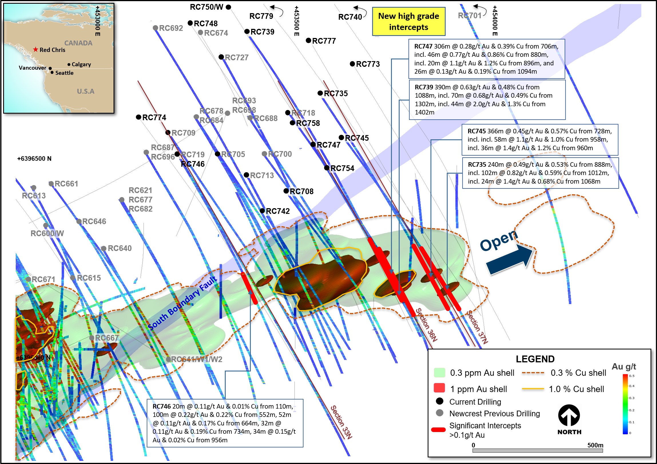
Figure 7. Schematic plan view map of the East Ridge showing drill hole locations (Newcrest & Imperial) and significant Newcrest intercepts (drill intercepts have been reported in Appendix 1 of this report, and in prior Newcrest exploration releases). 0.3 g/t Au, 1 g/t Au, 0.3% Cu and 1% Cu shell projections generated from a Leapfrog model.
To view an enhanced version of Figure 7, please visit:
https://orders.newsfilecorp.com/files/7614/107125_0faf83f674be59d7_009full.jpg

Figure 8. Schematic cross section of RC746 and RC774 (Section Line 33N - as shown on Figure 7) showing Newcrest and Imperial drill holes and Newcrest intercepts (drill intercepts have been reported in Appendix 1 of this report, and in prior Newcrest exploration releases) 0.1 g/t Au, 0.5 g/t Au and 1 g/t Au shell projections generated from Leapfrog model. Due to window size (+/- 50m) and section orientation (150˚) hole may appear on multiple sections.
To view an enhanced version of Figure 8, please visit:
https://orders.newsfilecorp.com/files/7614/107125_0faf83f674be59d7_010full.jpg
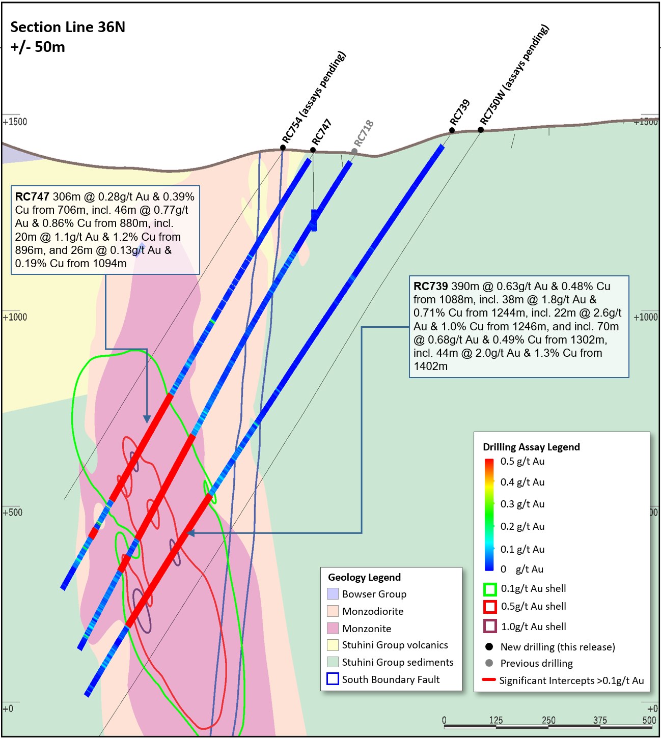
Figure 9. Schematic cross section of RC739 and RC747 (Section Line 36N - as shown on Figure 7) showing Newcrest and Imperial drill holes and Newcrest intercepts (drill intercepts have been reported in Appendix 1 of this report, and in prior Newcrest exploration releases) 0.1g/t, 0.5g/t Au and 1g/t Au shell projections generated from Leapfrog model. Due to window size (+/- 50m) and section orientation (150˚) hole may appear on multiple sections.
To view an enhanced version of Figure 9, please visit:
https://orders.newsfilecorp.com/files/7614/107125_0faf83f674be59d7_011full.jpg

Figure 10. Schematic cross section of RC735 and RC745 (Section Line 37N - as shown on Figure 7) showing Newcrest and Imperial drill holes and Newcrest intercepts (drill intercepts have been reported in Appendix 1 of this report, and in prior Newcrest exploration releases) 0.1g/t, 0.5g/t Au and 1g/t Au shell projections generated from Leapfrog model. Due to window size (+/- 50m) and section orientation (150˚) hole may appear on multiple sections.
To view an enhanced version of Figure 10, please visit:
https://orders.newsfilecorp.com/files/7614/107125_0faf83f674be59d7_012full.jpg
Appendix 2
Havieron Project (Greatland Gold Plc - Joint Venture Agreement): JORC Table 1
Section 1: Sampling Techniques and Data
| Criteria | Commentary |
| Sampling techniques | Core samples are obtained from core drilling in Proterozoic basement lithologies. PQ-HQ and NQ diameter core was drilled on a 6m run. Core was cut using an automated core-cutter and half core sampled at 1m intervals with breaks for major geological changes. Sampling intervals range from 0.2 - 1.0m. Cover sequences were not sampled. |
| Drilling techniques | Permian Paterson Formation cover sequence was drilled using mud rotary drilling. Depths of cover typically observed to approximately 420m vertically below surface. Steel casing was emplaced to secure the pre-collar. Core drilling was advanced from the base of the cover sequence with PQ3, HQ3 and NQ2 diameter coring configuration. Core from inclined drill holes are oriented on 3m and 6m runs using an electronic core orientation tool (Reflex ACTIII). At the end of each run, the bottom of hole position is marked by the driller, which is later transferred to the whole drill core run length with a bottom of hole reference line. |
| Drill sample recovery | Core recovery is systematically recorded from the commencement of coring to end of hole, by reconciling against driller's depth blocks in each core tray with data recorded in the database. Drillers depth blocks provided the depth, interval of core recovered, and interval of core drilled. Core recoveries were typically 100%, with isolated zones of lower recovery. Cover sequence drilling by the mud-rotary drilling did not yield recoverable samples. |
| Logging | Geological logging recorded qualitative descriptions of lithology, alteration, mineralisation, veining, and structure (for all core drilled - 7,634.4 m for 12 drill holes, all intersecting mineralisation), including orientation of key geological features. Geotechnical measurements were recorded including Rock Quality Designation (RQD) fracture frequency, solid core recovery and qualitative rock strength measurements. Magnetic susceptibility measurements were recorded every metre. The bulk density of selected drill core intervals was determined at site on whole core samples. All geological and geotechnical logging was conducted at the Havieron site. Digital data logging was captured on diamond drill core intervals only, and all data validated and stored in an acQuire database. All drill cores were photographed, prior to cutting and/or sampling the core. The logging is of sufficient quality to support Mineral Resource estimates. |
| Sub-sampling techniques and sample preparation | Sampling, sample preparation and quality control protocols are considered appropriate for the material being sampled. Core was cut and sampled at the Havieron core processing facility. Half core samples of between 0.2 and 2.0 m were collected in pre-numbered calico bags and grouped in plastic bags for dispatch to the laboratory. Sample weights typically varied from 0.5 to 8kg. Sample sizes are considered appropriate for the style of mineralisation. Drill core samples were freighted by air and road to the laboratory. Sample preparation was conducted at the independent ISO17025 accredited Intertek Laboratory, Perth (Intertek). Samples were dried at 105oC, and crushed to 95% passing 4.75mm, and the split to obtain up to 3kg sub-sample, which was pulverised (using LM5) to produce a pulped product with the minimum standard of 95% passing 106μm. Routine grind size analysis is conducted. Duplicate samples were collected from crush and pulp samples at a rate of 1:20. Duplicate results show an acceptable level of variability for the material sampled and style of mineralisation. Periodic size checks (1:20) for crush and pulp samples and sample weights are provided by the laboratory and recorded in the acQuire database. |
| Quality of assay data and laboratory tests | Assaying of drill core samples was conducted at Intertek. All samples were assayed for 48 elements using a 4-acid digestion followed by ICP-AES/ICP-MS determination (method 4A/MS907), which is considered to provide a total assay for copper. Gold analyses were determined by 50g fire assay with AAS finish (method FA50N/AA), which is considered to provide a total assay for gold. Sampling and assaying quality control procedures consisted of inclusion of certified reference material (CRMs), coarse residue and pulp duplicates with each batch (at least 1:20). Assays of quality control samples were compared with reference samples in acQuire database and verified as acceptable prior to use of data from analysed batches. Laboratory quality control data, including laboratory standards, blanks, duplicates, repeats and grind size results are captured in the acQuire database and assessed for accuracy and precision for recent data. Extended quality control programs including pulp samples submitted to an umpire laboratory and combined with more extensive re-submission programs have been completed. Analysis of the available quality control sample assay results indicates that an acceptable level of accuracy and precision has been achieved and the database contains no analytical data that has been numerically manipulated. The assaying techniques and quality control protocols used are considered appropriate for the data to be used for reporting exploration drilling results. |
| Verification of sampling and assaying | Sampling intervals defined by the geologist are electronically assigned sample identification numbers prior to core cutting. Corresponding sample numbers matching pre-labelled calico bags are assigned to each interval. All sampling and assay information were stored in a secure acQuire database with restricted access. Electronically generated sample submission forms providing the sample identification number accompany each submission to the laboratory. Assay results from the laboratory with corresponding sample identification are loaded directly into the acQuire database. Assessment of reported significant assay intervals was verified by re-logging of diamond drill core intervals and assessment of high resolution core photography. The verification of significant intersections has been completed by company personnel and the Competent Person/Qualified Person. No adjustments are made to assay data, and no twinned holes have been completed. There are no currently known drilling, sampling, recovery, or other factors that could materially affect the accuracy or reliability of the data. |
| Location of data points | Drill collar locations were surveyed using a differential GPS with GNSS with a stated accuracy of +/- 0.5m for all drill holes reported. Drill rig alignment was attained using an electronic azimuth aligner. Downhole survey was collected at 6-12m intervals in the cover sequence, and every 6 to 30m in diamond drill core segments of the drill hole using single shot (Axis Mining Champ Gyro). The single shot surveys have been validated using continuous survey to surface (Axis Mining Champ) along with a selection of drill holes re-surveyed by an external survey contactor using a DeviGyro tool - confirming sufficient accuracy for downhole spatial recording. A LIDAR survey was completed over the project area in Nov 2019 which was used to prepare a DEM / topographic model for the project with a spatial accuracy of +/- 0.1m vertical and +/- 0.3m horizontal. The topography is generally low relief to flat, elevation within the dune corridors in ranges between 250-265m Australian Height Datum (AHD) steepening to the southeast. All collar coordinates are provided in the Geocentric Datum of Australian (GDA20 Zone 51). All relative depth information is reported in AHD +5000m. |
| Data spacing and distribution | Within the South-East Crescent and Breccia zone drill hole spacing ranges from 50 to 100m, to 50 by 50m within the resource extents. Outside the initial resource boundary drill hole spacing ranges from 50 to 200m in lateral extent within the breccia zone over an area of ~2km2. The data spacing is sufficient to establish the degree of geological and grade continuity. Significant assay intercepts remain open. Further drilling is required to determine the extent of currently defined mineralisation. No sample compositing is applied to samples. Drilling intersects mineralisation at various angles. |
| Orientation of data in relation to geological structure | Drill holes exploring the extents of the Havieron mineral system intersect moderately dipping carbonate and siliclastic sedimentary facies, mineralised breccia and sub-vertical intrusive lithologies. Geological modelling has been interpreted from historic and Newcrest drill holes. Variable brecciation, alteration and sulphide mineralisation is observed with a footprint with dimensions of 650m x 350m trending in a north west orientation and over 1000m in vertical extent below cover. The subvertical southeast high grade arcuate crescent sulphide zone has an average thickness of 20m and has been defined over a strike length of up to 550m, and extended to over 700m in vertical extent below cover. Drilling direction is oriented to intersect the steeply dipping high-grade sulphide mineralisation zones at an intersection angle of greater than 40 degrees. The drilled length of reported intersections is typically greater than true width of mineralisation. |
| Sample security | The security of samples is controlled by tracking samples from drill rig to database. Drill core was delivered from the drill rig to the Havieron core yard every shift. On completion of geological and geotechnical logging, core processing was completed by Newcrest personnel at the Havieron facility. High resolution core photography and cutting of drill core was undertaken at the Havieron core processing facilities. Samples were freighted in sealed bags by air and road to the Laboratory, and in the custody of Newcrest representatives. Sample numbers are generated directly from the database. All samples are collected in pre-numbered calico bags. Verification of sample numbers and identification is conducted by the laboratory on receipt of samples, and sample receipt advise issued to Newcrest. Details of all sample movement are recorded in a database table. Dates, Hole ID sample ranges, and the analytical suite requested are recorded with the dispatch of samples to analytical services. Any discrepancies logged at the receipt of samples into the analytical services are validated. |
| Audits or reviews | Internal reviews of core handling, sample preparation and assays laboratories were conducted on a regular basis by both project personnel and owner representatives. In the Competent Person's opinion, the sample preparation, security and analytical procedures are consistent with current industry standards and are entirely appropriate and acceptable for the styles of mineralisation identified and will be appropriate for use in the reporting of exploration results and Mineral Resource estimates. There are no identified drilling, sampling or recovery factors that materially impact the adequacy and reliability of the results of the drilling programme in place at the Havieron Project. |
Section 2: Reporting of Exploration Results
| Criteria | Commentary |
| Mineral tenement and land tenure status | The Havieron Project is entirely contained within mining tenement M45/1287, which is jointly owned by Greatland Pty Ltd and Newcrest Operations Limited. Newcrest has entered into a Joint Venture Agreement (effective 30 November 2020) and Farm-In Agreement (effective 12 March 2019) with Greatland Pty Ltd and Greatland Gold plc. Newcrest is the Manager of the Havieron Project. Newcrest has now met the Stage 3 farm-in requirement and has earnt an additional 20% joint venture interest, resulting in a joint venture interest of 60%. Following the delivery of the PFS on 12 October 2021, Newcrest is entitled to earn an additional 10% joint venture interest, resulting in an overall joint venture interest of 70% (Greatland Gold 30%). Newcrest also has an option to acquire a further 5% at fair market value. Newcrest and WDLAC are parties to an ILUA which relates to the use of native title land for Newcrest's current operations at Telfer and its activities within a 60-km radius around Telfer and includes its exploration activities at Havieron. The parties have agreed that the ILUA will apply to any future development activities by the Joint Venture Participants (Newcrest and Greatland Gold) at Havieron. The mining tenement M45/1287 wholly replaces the 12 sub-blocks of exploration tenement E45/4701 (former exploration tenement on which the Havieron Project is based) and was granted on 10 September 2020. All obligations with respect to legislative requirements including minimum expenditure are maintained in good standing for prior exploration tenement E45/4701. |
| Exploration done by other parties | Newcrest completed six core holes in the vicinity of the Havieron Project from 1991 to 2003. Greatland Gold completed drill targeting and drilling of nine Reverse Circulation (RC) drill holes with core tails for a total of approximately 6,800m in 2018. Results of drilling programs conducted by Greatland Gold have previously been reported on the Greatland Gold website. Drilling has defined an intrusion-related mineral system with evidence of breccia and massive sulphide-hosted higher-grade gold-copper mineralisation. |
| Geology | The Havieron Project is located within the north-western exposure of the Palaeo-Proterozoic to Neoproterozoic Paterson Orogen (formerly Paterson Province), 45 km east of Telfer. The Yeneena Supergroup hosts the Havieron prospect and consists of a 9km thick sequence of marine sedimentary rocks and is entirely overlain by approximately 420m of Phanerozoic sediments of the Paterson Formation and Quaternary aeolian sediments. Gold and copper mineralisation at Havieron consist of breccia, vein and massive sulphide replacement gold and copper mineralisation typical of intrusion-related and skarn styles of mineralisation. Mineralisation is hosted by metasedimentary rocks (meta-sandstones, meta-siltstones and meta-carbonate) and intrusive rocks of an undetermined age. The main mineral assemblage contains well developed pyrrhotite-chalcopyrite and pyrite sulphide mineral assemblages as breccia and vein infill, and massive sulphide lenses. The main mineralisation event is associated with amphibole-carbonate-biotite-sericite-chlorite wall rock alteration. Drilling has partially defined the extents of mineralisation which are observed over 650m by 350m within an arcuate shaped mineralised zone, and to depths of up to 1400m below surface. |
| Drill hole Information | As provided. |
| Data aggregation methods | Significant assay intercepts are reported as (A) length-weighted averages exceeding 1.0g/t Au greater than or equal to 10m, with a maximum of 5m consecutive internal dilution; and (B) length-weighted averages exceeding 0.2g/t Au for greater than or equal to 20m, with a maximum of 10m consecutive internal dilution, and (C) intervals of >30g/t which are greater or equal to 30 gram metres (Au_ppm x length). No top cuts are applied to intercept calculations. |
| Relationship between mineralisation widths and intercept lengths | Significant assay intervals reported represent apparent widths. Drilling is not always perpendicular to the dip of mineralisation and true widths are less than downhole widths. Estimates of true widths will only be possible when all results are received, and final geological interpretations have been completed. |
| Diagrams | As provided. |
| Balanced reporting | This is the twentieth release of Exploration Results for this project made by Newcrest. Previous release dates are 25 July 2019, 10 September 2019, 24 October 2019, 2 December 2019, 30 January 2020, 11 March 2020, 30 April 2020, 11 June 2020, 23 July 2020, 10 September 2020, 29 October 2020, 10 December 2020, 28 January 2021, 11 March 2021, 29 April 2021, 10 June 2021, 22 July 2021, 9 September 2021 and 28 October 2021. Earlier reporting of exploration programs conducted by Newcrest and Greatland Gold have previously been reported. Exploration drilling programs are ongoing and further material results will be reported in subsequent Newcrest releases. |
| Other substantive exploration data | Nil |
| Further work | Growth drilling is planned to extend the December 2020 Inferred Mineral Resource estimate and define the limits of the Havieron mineralised system. |
Drillhole data(1)
Havieron Project, Paterson Province, Western Australia
Reporting Criteria: Intercepts reported are downhole drill width (not true width) Au >0.20ppm (0.2g/t Au) and minimum 20m downhole width with maximum consecutive internal dilution of 10m. Average grades are based on length-weighting of samples grades. Also highlighted are high grade intervals of Au >1.0ppm (1g/t Au) and minimum 10m downhole width with maximum consecutive internal dilution of 5m, and intervals of >30g/t which are greater or equal to 30 gram metres (Au_ppm x length) are tabled. Gold grades are reported to two significant figures, the downhole lengths are rounded to 0.1m which may cause some apparent discrepancies in interval widths. Samples are from core drilling which is PQ, HQ or NQ in diameter. Core is photographed and logged by the geology team before being cut. Half core PQ, HQ and NQ samples are prepared for assay and the remaining material is retained in the core farm for future reference. Each assay batch is submitted with duplicates and standards to monitor laboratory quality. Total depth (end of hole) is rounded to one decimal place for reporting purposes. Collars denoted with a * show partial results, with further significant assays to be reported in subsequent exploration updates.
| Hole ID | Hole Type | Easting (m) | Northing (m) | RL (m) | Total Depth (m) | Azimuth | Dip | From (m) | To (m) | Interval (m) | Au (ppm) | Cu (pct) | Cut off |
| HAD053W5 | MR-DD | 463846 | 7598077 | 256 | 1207 | 132 | -61 | 568.8 | 589.8 | 21 | 0.21 | 0.08 | 0.2 g/t Au |
| 636.2 | 718.2 | 82 | 0.55 | 0.21 | 0.2 g/t Au | ||||||||
| 777.3 | 802.6 | 25.3 | 0.21 | 0.09 | 0.2 g/t Au | ||||||||
| 886.2 | 927.6 | 41.4 | 1.6 | 0.11 | 0.2 g/t Au | ||||||||
| 957.7 | 958.5 | 0.8 | 94 | 4.2 | 30 g.m. Au | ||||||||
| 1041.4 | 1161.1 | 119.7 | 1.2 | 0.49 | 0.2 g/t Au | ||||||||
| Incl. | 1041.4 | 1052 | 10.6 | 5.3 | 0.26 | 1.0 g/t Au | |||||||
| Incl. | 1083 | 1093.5 | 10.5 | 0.53 | 0.30 | 1.0 g/t Au | |||||||
| Incl. | 1119 | 1132.5 | 13.5 | 4.1 | 0.61 | 1.0 g/t Au | |||||||
| HAD053W6 | MR-DD | 463845 | 7598075 | 256 | 1302.4 | 132 | -61 | 609.3 | 722 | 112.7 | 0.21 | 0.12 | 0.2 g/t Au |
| 958.4 | 981.2 | 22.8 | 1.6 | 0.19 | 0.2 g/t Au | ||||||||
| 1008.4 | 1054.8 | 46.4 | 0.75 | 0.18 | 0.2 g/t Au | ||||||||
| 1065 | 1229.3 | 164.3 | 1.8 | 0.53 | 0.2 g/t Au | ||||||||
| Incl. | 1065.7 | 1080 | 14.3 | 9.7 | 0.78 | 1.0 g/t Au | |||||||
| Incl. | 1072 | 1074 | 2 | 26 | 0.73 | 30 g.m. Au | |||||||
| Incl. | 1086 | 1098.8 | 12.8 | 2.7 | 0.64 | 1.0 g/t Au | |||||||
| Incl. | 1165.1 | 1177.7 | 12.6 | 2.9 | 0.78 | 1.0 g/t Au | |||||||
| HAD058W1 | MR-DD | 463718 | 7597439 | 260 | 1325.6 | 43 | -50 | Assays Pending | |||||
| HAD061W1 | MR-DD | 464367 | 7598038 | 257 | 1010.1 | 206 | -61 | 557.6 | 589.5 | 31.9 | 0.49 | 0.04 | 0.2 g/t Au |
| 774.6 | 842.9 | 68.3 | 0.63 | 0.11 | 0.2 g/t Au | ||||||||
| 856.3 | 1001 | 144.7 | 1.6 | 0.14 | 0.2 g/t Au | ||||||||
| HAD061W2 | MR-DD | 464367 | 7598038 | 257 | 997.3 | 206 | -61 | 535.1 | 593.3 | 58.2 | 1.7 | 0.42 | 0.2 g/t Au |
| 622.4 | 676.6 | 54.2 | 0.14 | 0.02 | 0.2 g/t Au | ||||||||
| 686.8 | 729.2 | 42.4 | 0.84 | 0.03 | 0.2 g/t Au | ||||||||
| 824.8 | 847.4 | 22.6 | 0.48 | 0.18 | 0.2 g/t Au | ||||||||
| 868.4 | 936.4 | 68 | 0.67 | 0.27 | 0.2 g/t Au | ||||||||
| Incl. | 886.6 | 899.6 | 13 | 1.6 | 0.44 | 1.0 g/t Au | |||||||
| HAD061W3 | MR-DD | 464367 | 7598038 | 257 | 540 | 206 | -61 | No Significant Assays | |||||
| HAD061W4 | MR-DD | 464368 | 7598039 | 257 | 1082.4 | 206 | -61 | 615.8 | 644 | 28.2 | 0.63 | 0.01 | 0.2 g/t Au |
| 708.4 | 741 | 32.6 | 0.91 | 0.07 | 0.2 g/t Au | ||||||||
| 884.1 | 912 | 27.9 | 0.44 | 0.29 | 0.2 g/t Au | ||||||||
| 925.4 | 1053.5 | 128.1 | 0.66 | 0.09 | 0.2 g/t Au | ||||||||
| HAD068W4 | MR-DD | 464547 | 7597081 | 261 | 1170.1 | 323 | -55 | 1082 | 1129 | 47 | 0.77 | 0.35 | 0.2 g/t Au |
| 1140.7 | 1168.8 | 28.1 | 0.31 | 0.11 | 0.2 g/t Au | ||||||||
| HAD076W1 | MR-DD | 464373 | 7598130 | 257 | 1122.3 | 227 | -55 | 613 | 633.8 | 20.8 | 0.16 | 0.20 | 0.2 g/t Au |
| 689.2 | 730.3 | 41.1 | 1.0 | 0.06 | 0.2 g/t Au | ||||||||
| 742 | 792.4 | 50.4 | 0.18 | 0.03 | 0.2 g/t Au | ||||||||
| Incl. | 900.2 | 900.5 | 0.3 | 121 | 0.01 | 30 g.m. Au | |||||||
| 964.4 | 1025.1 | 60.7 | 0.17 | 0.05 | 0.2 g/t Au | ||||||||
| Incl. | 1053 | 1054.5 | 1.5 | 29 | 1.6 | 30 g.m. Au | |||||||
| HAD084W3 | MR-DD | 463271 | 7597843 | 256 | 1311 | 83 | -65 | Assays Pending | |||||
| HAD085W1 | MR-DD | 463488 | 7598056 | 255 | 1580.4 | 111 | -63 | 1434.9 | 1438 | 3.1 | 73 | 0.29 | 30 g.m. Au |
| 1466 | 1496 | 30 | 1.1 | 0.19 | 0.2 g/t Au | ||||||||
| 1507 | 1568 | 61 | 1.1 | 0.17 | 0.2 g/t Au | ||||||||
| Incl. | 1527.8 | 1539 | 11.2 | 5.3 | 0.39 | 1.0 g/t Au | |||||||
| Incl. | 1531.9 | 1532.7 | 0.8 | 43 | 0.01 | 30 g.m. Au | |||||||
| HAD085W2 | MR-DD | 463488 | 7598056 | 255 | 1397.1 | 112 | -63 | 607.6 | 636.5 | 28.9 | 0.85 | 0.09 | 0.2 g/t Au |
| Incl. | 614.5 | 628.3 | 13.8 | 1.3 | 0.14 | 1.0 g/t Au | |||||||
| 648 | 771.5 | 123.5 | 0.41 | 0.07 | 0.2 g/t Au | ||||||||
| 813.6 | 814.8 | 1.2 | 25 | 0.31 | 30 g.m. Au | ||||||||
| 940.4 | 967.9 | 27.5 | 0.26 | 0.05 | 0.2 g/t Au | ||||||||
| 1066.8 | 1120.2 | 53.4 | 0.33 | 0.02 | 0.2 g/t Au | ||||||||
| 1134 | 1163.2 | 29.2 | 0.39 | 0.14 | 0.2 g/t Au | ||||||||
| 1256.2 | 1333.4 | 77.2 | 0.36 | 0.16 | 0.2 g/t Au | ||||||||
| Incl. | 1256.2 | 1269.2 | 13 | 1.3 | 0.12 | 1.0 g/t Au | |||||||
| HAD085W3 | MR-DD | 463489 | 7598058 | 255 | 1267.8 | 111 | -63 | Hole Abandoned | |||||
| HAD085W4 | MR-DD | 463489 | 7598058 | 255 | 1534.2 | 111 | -63 | Assays Pending | |||||
| HAD086W2 | MR-DD | 464623 | 7598148 | 258 | 1629.6 | 225 | -65 | Assays Pending | |||||
| HAD086W3^^** | MR-DD | 464623 | 7598148 | 258 | 1624 | 225 | -65 | 991.5 | 1330 | Assays Pending | |||
| 1373 | 1398.7 | 25.7^^ | 2 | 0.11 | 0.2 g/t Au | ||||||||
| Incl. | 1373.8 | 1375 | 1.2 | 29 | 0.76 | 30 g.m. Au | |||||||
| 1412 | 1456.7 | 44.7^^ | 7.1 | 0.17 | 0.2 g/t Au | ||||||||
| Incl. | 1421 | 1441.2 | 20.2^^ | 15 | 0.29 | 1.0 g/t Au | |||||||
| Incl. | 1421 | 1424.9 | 3.9 | 47 | 0.33 | 30 g.m. Au | |||||||
| Incl. | 1431.7 | 1433.5 | 1.8 | 50 | 0.45 | 30 g.m. Au | |||||||
| 1525 | 1573 | 48 | 2.2 | 0.15 | 0.2 g/t Au | ||||||||
| Incl. | 1538.1 | 1565 | 26.9 | 3.7 | 0.26 | 1.0 g/t Au | |||||||
| HAD086W4** | MR-DD | 464623 | 7598148 | 258 | 2115.3 | 225 | -65 | 1404.3 | 1506.6 | 102.3 | 1.5 | 0.17 | 0.2 g/t Au |
| Incl. | 1437.3 | 1438.8 | 1.5 | 72 | 0.20 | 30 g.m. Au | |||||||
| 1550 | 2115.3 | Assays Pending | |||||||||||
| 1602 | 1623 | 21 | 0.36 | 0.30 | 0.2 g/t Au | ||||||||
| HAD133W4 | MR-DD | 464071 | 7598315 | 257 | 1468.5 | 171 | -65 | 1153.2 | 1181.4 | 28.2 | 0.08 | 0.05 | 0.2 g/t Au |
| 1329.2 | 1399 | 69.8 | 2.0 | 0.32 | 0.2 g/t Au | ||||||||
| Incl. | 1334 | 1344.1 | 10.1 | 5.8 | 0.18 | 1.0 g/t Au | |||||||
| Incl. | 1339.8 | 1341 | 1.2 | 27 | 0.01 | 30 g.m. Au | |||||||
| Incl. | 1368.4 | 1392.9 | 24.5 | 3.0 | 0.62 | 1.0 g/t Au | |||||||
| HAD133W5 | MR-DD | 464071 | 7598315 | 257 | 1543.9 | 171 | -65 | 1339.3 | 1381 | 41.7 | 0.31 | 0.03 | 0.2 g/t Au |
| 1418.6 | 1529 | 110.4 | 2.2 | 0.21 | 0.2 g/t Au | ||||||||
| Incl. | 1460.5 | 1523.3 | 62.8 | 3.0 | 0.16 | 1.0 g/t Au | |||||||
| Incl. | 1478.2 | 1478.5 | 0.3 | 100 | 0.02 | 30 g.m. Au | |||||||
| HAD133W6 | MR-DD | 464072 | 7598317 | 257 | 1639.5 | 171 | -65 | Assays Pending | |||||
| HAD141W1 | MR-DD | 463362 | 7597504 | 264 | 1985.9 | 27 | -65 | Assays Pending | |||||
| HAD146 | MR-DD | 463451 | 7597873 | 253 | 1121.7 | 68 | -62 | Assays Pending | |||||
| HAD146W1 | MR-DD | 463451 | 7597873 | 253 | 1189.4 | 69 | -60 | Assays Pending | |||||
| HAD148 | MR-DD | 464317 | 7598100 | 257 | 990.7 | 222 | -55 | 574.1 | 617.8 | 43.7 | 0.24 | 0.04 | 0.2 g/t Au |
| 733.4 | 760.1 | 26.7 | 0.13 | 0.01 | 0.2 g/t Au | ||||||||
| 781.2 | 813.2 | 32 | 0.48 | 0.02 | 0.2 g/t Au | ||||||||
| 829.3 | 914.6 | 85.3 | 0.41 | 0.08 | 0.2 g/t Au | ||||||||
| HAD148W1 | MR-DD | 464317 | 7598100 | 257 | 1008.5 | 222 | -55 | 729 | 784.4 | 55.4 | 0.29 | 0.03 | 0.2 g/t Au |
| 807.8 | 897.1 | 89.3 | 1.3 | 0.05 | 0.2 g/t Au | ||||||||
| Incl. | 839.3 | 840.1 | 0.8 | 39 | 1.0 | 30 g.m. Au | |||||||
| Incl. | 867.2 | 883.1 | 15.9 | 3.9 | 0.14 | 1.0 g/t Au | |||||||
| Incl. | 872.5 | 874.5 | 2 | 18 | 0.23 | 30 g.m. Au | |||||||
| 915.4 | 952 | 36.6 | 2.0 | 0.11 | 0.2 g/t Au | ||||||||
| 967.3 | 996 | 28.7 | 0.59 | 0.11 | 0.2 g/t Au | ||||||||
| Incl. | 967.3 | 978.9 | 11.6 | 1.3 | 0.23 | 1.0 g/t Au | |||||||
| HAD148W2 | MR-DD | 464317 | 7598100 | 257 | 1049.3 | 222 | -55 | 576 | 623.8 | 47.8 | 0.92 | 0.05 | 0.2 g/t Au |
| 680 | 681.1 | 1.1 | 29 | 3.6 | 30 g.m. Au | ||||||||
| 800.2 | 853.3 | 53.1 | 0.36 | 0.09 | 0.2 g/t Au | ||||||||
| 867 | 900 | 33 | 1.9 | 0.05 | 0.2 g/t Au | ||||||||
| Incl. | 874.4 | 875 | 0.6 | 52 | 0.08 | 30 g.m. Au | |||||||
| 938.1 | 973.5 | 35.4 | 4.4 | 0.25 | 0.2 g/t Au | ||||||||
| Incl. | 955.9 | 957.8 | 2 | 70 | 2.6 | 30 g.m. Au | |||||||
| 984.5 | 1005.9 | 21.4 | 0.14 | 0.02 | 0.2 g/t Au | ||||||||
| HAD149 | MR-DD | 464243 | 7598106 | 256 | 1282.7 | 209 | -60 | 807.6 | 863.9 | 56.3 | 0.61 | 0.11 | 0.2 g/t Au |
| 881.3 | 913.8 | 32.5 | 0.25 | 0.03 | 0.2 g/t Au | ||||||||
| 952.6 | 992.9 | 40.3 | 0.28 | 0.02 | 0.2 g/t Au | ||||||||
| HAD149W1 | MR-DD | 464243 | 7598106 | 256 | 1002.3 | 209 | -60 | 572 | 653 | 81 | 0.42 | 0.04 | 0.2 g/t Au |
| 750.4 | 773 | 22.6 | 0.18 | 0.02 | 0.2 g/t Au | ||||||||
| 819 | 861.2 | 42.2 | 0.27 | 0.04 | 0.2 g/t Au | ||||||||
| 875.5 | 932 | 56.5 | 0.33 | 0.02 | 0.2 g/t Au | ||||||||
| 950.5 | 952 | 1.5 | 36 | 0.11 | 30 g.m. Au | ||||||||
| HAD149W2 | MR-DD | 464245 | 7598108 | 256 | 1283.3 | 209 | -60 | 510.5 | 545 | 34.5 | 0.18 | 0.23 | 0.2 g/t Au |
| 663.9 | 720 | 56.1 | 0.18 | 0.05 | 0.2 g/t Au | ||||||||
| 841.3 | 908 | 66.7 | 0.42 | 0.07 | 0.2 g/t Au | ||||||||
| 919.5 | 964.6 | 45.1 | 6.7 | 0.06 | 0.2 g/t Au | ||||||||
| Incl. | 961.7 | 962.7 | 1 | 244 | 0.85 | 30 g.m. Au | |||||||
| HAD150 | MR-DD | 464078 | 7598228 | 256 | 1128.7 | 172 | -58 | 590.8 | 647.8 | 57 | 0.20 | 0.03 | 0.2 g/t Au |
| 663 | 756.7 | 93.7 | 0.25 | 0.10 | 0.2 g/t Au | ||||||||
| 784.2 | 832.1 | 47.9 | 0.14 | 0.02 | 0.2 g/t Au | ||||||||
| 885.1 | 972 | 86.9 | 0.41 | 0.05 | 0.2 g/t Au | ||||||||
| 985.8 | 1015.6 | 29.8 | 1.9 | 0.22 | 0.2 g/t Au | ||||||||
| Incl. | 988.8 | 989.1 | 0.3 | 175 | 0.07 | 30 g.m. Au | |||||||
| HAD150W1 | MR-DD | 464078 | 7598228 | 256 | 1155 | 172 | -58 | 658.8 | 699.4 | 40.6 | 0.19 | 0.14 | 0.2 g/t Au |
| 710 | 737.9 | 27.9 | 0.24 | 0.37 | 0.2 g/t Au | ||||||||
| 805.7 | 856.5 | 50.8 | 0.62 | 0.06 | 0.2 g/t Au | ||||||||
| 909 | 1049 | 140 | 2.9 | 0.07 | 0.2 g/t Au | ||||||||
| Incl. | 952.4 | 955.1 | 2.7 | 50 | 0.07 | 30 g.m. Au | |||||||
| Incl. | 966 | 979 | 13 | 5.1 | 0.09 | 1.0 g/t Au | |||||||
| Incl. | 974.7 | 975.1 | 0.4 | 74 | 0.22 | 30 g.m. Au | |||||||
| Incl. | 986 | 998.9 | 12.9 | 2.9 | 0.17 | 1.0 g/t Au | |||||||
| Incl. | 1023.6 | 1034.3 | 10.7 | 5.6 | 0.16 | 1.0 g/t Au | |||||||
| 1061 | 1093.1 | 32.1 | 1.1 | 0.26 | 0.2 g/t Au | ||||||||
| HAD150W2 | MR-DD | 464080 | 7598231 | 256 | 1230.1 | 172 | -58 | 767.6 | 813.2 | 45.6 | 1.9 | 0.20 | 0.2 g/t Au |
| Incl. | 802 | 802.8 | 0.8 | 40 | 0.71 | 30 g.m. Au | |||||||
| 940.9 | 983 | 42.1 | 1.4 | 0.07 | 0.2 g/t Au | ||||||||
| Incl. | 975.7 | 976.8 | 1.1 | 33 | 0.49 | 30 g.m. Au | |||||||
| 996.2 | 1110 | 113.8 | 3.4 | 0.10 | 0.2 g/t Au | ||||||||
| Incl. | 1011.4 | 1023.3 | 11.9 | 5.7 | 0.11 | 1.0 g/t Au | |||||||
| Incl. | 1021 | 1022 | 1 | 37 | 0.14 | 30 g.m. Au | |||||||
| incl. | 1035.8 | 1050 | 14.2 | 20 | 0.14 | 1.0 g/t Au | |||||||
| Incl. | 1035.8 | 1043 | 7.2 | 36 | 0.14 | 30 g.m. Au | |||||||
| HAD151 | MR-DD | 463591 | 7597377 | 263 | 794.3 | 48 | -55 | 708.6 | 794.3 | 85.7 | 0.31 | 0.07 | 0.2 g/t Au |
| HAD151W1 | MR-DD | 463591 | 7597377 | 263 | 808 | 48 | -55 | 692.2 | 772.0 | 79.8 | 0.68 | 0.08 | 0.2 g/t Au |
| 705 | 719 | 14 | 2.3 | 0.08 | 1.0 g/t Au | ||||||||
| NOR01 | MR-DD | 464122 | 7599991 | 264 | 1248.4 | 90 | -70 | Assays Pending | |||||
| ZIP001 | MR-DD | 463055 | 7599813 | 258 | 900.8 | 45 | -70 | Assays Pending | |||||
#drilling in progress. **partial intercept, assays pending. ^updated intercept. ^^previously reported intercept.

Figure 11. Schematic plan view map showing drill hole locations and significant intercepts reported in this release superimposed on the interpreted geology. Previously reported holes are not shown for the sake of clarity. Note some holes and results appear on multiple sections due to the sections orientation and sections overlap.
To view an enhanced version of Figure 11, please visit:
https://orders.newsfilecorp.com/files/7614/107125_0faf83f674be59d7_013full.jpg

Figure 12. Schematic cross section of geology and significant new drillhole intercepts (looking northwest, Section Line S1, +/-50m section width, as shown in Figure 11). Due to section window size and orientation holes may appear on multiple sections. This diagram highlights >100gram metres intersections drilled during the period which are >1g/t Au.
To view an enhanced version of Figure 12, please visit:
https://orders.newsfilecorp.com/files/7614/107125_0faf83f674be59d7_014full.jpg

Figure 13. Schematic cross section of geology and significant new drillhole intercepts (looking northwest, Section Line S2, +/-50m section width, as shown in Figure 11). Due to section window size and orientation holes may appear on multiple sections. This diagram highlights >100gram metres intersections drilled during the period which are >1g/t Au.
To view an enhanced version of Figure 13, please visit:
https://orders.newsfilecorp.com/files/7614/107125_0faf83f674be59d7_015full.jpg
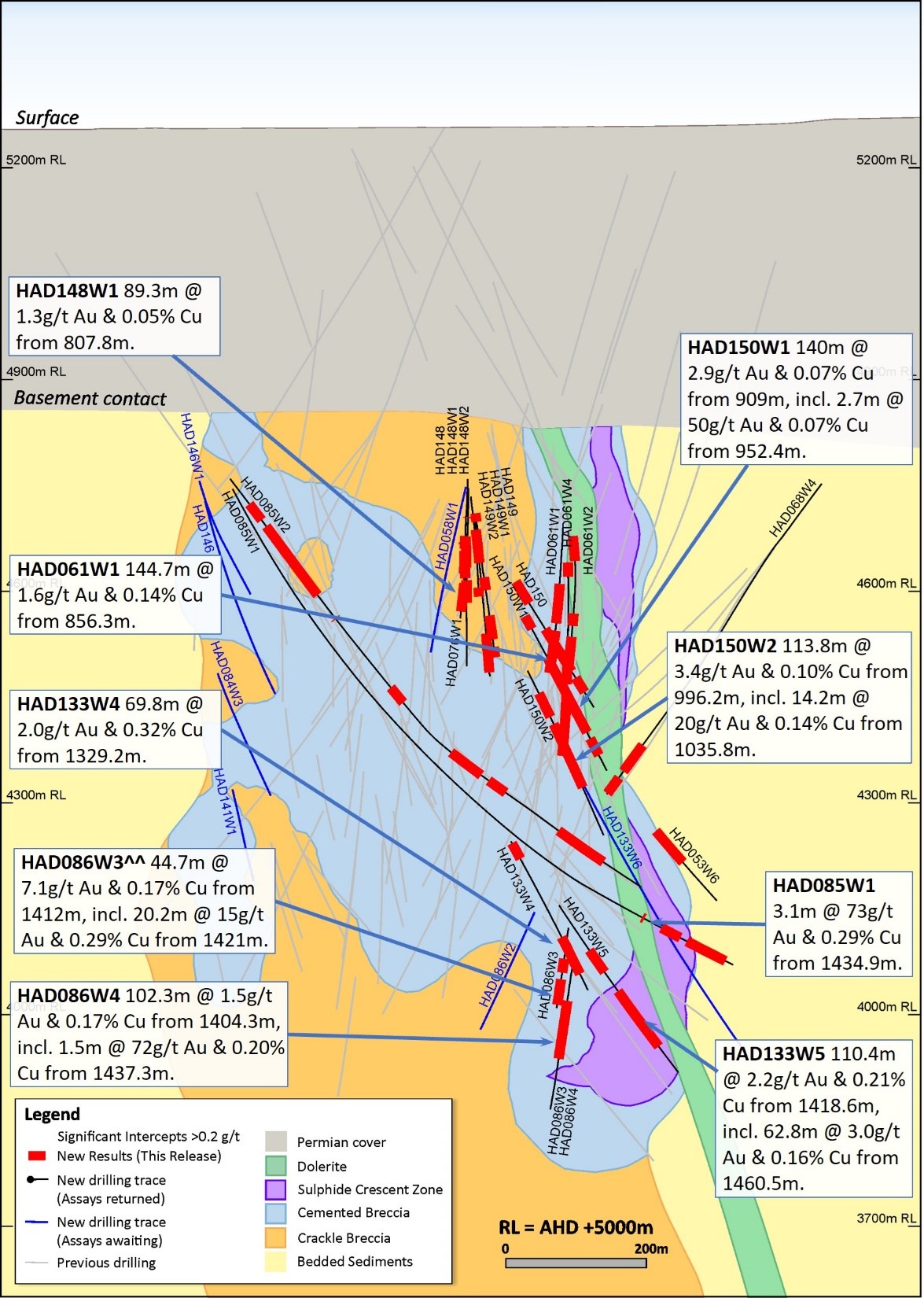
Figure 14. Schematic cross section of geology and significant new drillhole intercepts (looking northeast, Section Line S3, +/-50m section width, as shown in Figure 11). Due to section window size and orientation holes may appear on multiple sections. This diagram highlights >100gram metres intersections drilled during the period which are >1g/t Au.
To view an enhanced version of Figure 14, please visit:
https://orders.newsfilecorp.com/files/7614/107125_0faf83f674be59d7_016full.jpg
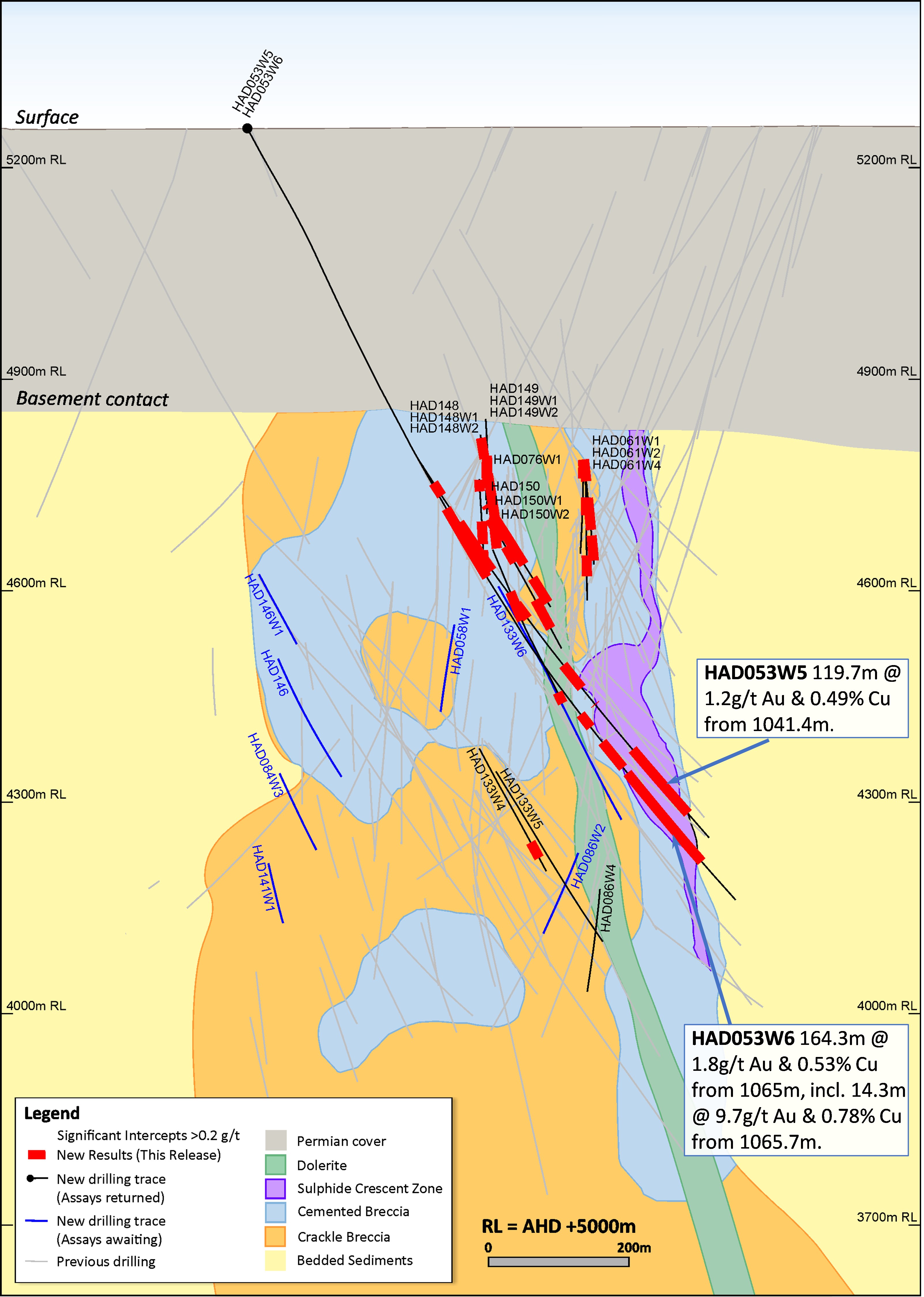
Figure 15. Schematic cross section of geology and significant new drillhole intercepts (looking northeast, Section Line S4, +/-50m section width, as shown in Figure 11). Due to section window size and orientation holes may appear on multiple sections. This diagram highlights >100gram metres intersections drilled during the quarter which are >1g/t Au.
To view an enhanced version of Figure 15, please visit:
https://orders.newsfilecorp.com/files/7614/107125_0faf83f674be59d7_017full.jpg
Forward Looking Statements
This document includes forward looking statements and forward looking information within the meaning of securities laws of applicable jurisdictions. Forward looking statements can generally be identified by the use of words such as "may", "will", "expect", "intend", "plan", "estimate", "anticipate", "believe", "continue", "objectives", "targets", "outlook" and "guidance", or other similar words and may include, without limitation, statements regarding estimated reserves and resources, certain plans, strategies, aspirations and objectives of management, anticipated production, study or construction dates, expected costs, cash flow or production outputs and anticipated productive lives of projects and mines. Newcrest continues to distinguish between outlook and guidance. Guidance statements relate to the current financial year. Outlook statements relate to years subsequent to the current financial year.
These forward looking statements involve known and unknown risks, uncertainties and other factors that may cause Newcrest's actual results, performance and achievements or industry results to differ materially from any future results, performance or achievements, or industry results, expressed or implied by these forward-looking statements. Relevant factors may include, but are not limited to, changes in commodity prices, foreign exchange fluctuations and general economic conditions, increased costs and demand for production inputs, the speculative nature of exploration and project development, including the risks of obtaining necessary licences and permits and diminishing quantities or grades of reserves, political and social risks, changes to the regulatory framework within which Newcrest operates or may in the future operate, environmental conditions including extreme weather conditions, recruitment and retention of personnel, industrial relations issues and litigation. For further information as to the risks which may impact on Newcrest's results and performance, please see the risk factors included in the Operating and Financial Review included in the Appendix 4E and Financial Report for the year ended 30 June 2021 and the Annual Information Form dated 6 December 2021 which are available to view at www.asx.com.au under the code "NCM" and on Newcrest's SEDAR profile.
Forward looking statements are based on Newcrest's good faith assumptions as to the financial, market, regulatory and other relevant environments that will exist and affect Newcrest's business and operations in the future. Newcrest does not give any assurance that the assumptions will prove to be correct. There may be other factors that could cause actual results or events not to be as anticipated, and many events are beyond the reasonable control of Newcrest. Readers are cautioned not to place undue reliance on forward looking statements, particularly in the current economic climate with the significant volatility, uncertainty and disruption caused by the COVID-19 pandemic. Forward looking statements in this document speak only at the date of issue. Except as required by applicable laws or regulations, Newcrest does not undertake any obligation to publicly update or revise any of the forward looking statements or to advise of any change in assumptions on which any such statement is based.
Ore Reserves and Mineral Resources Reporting Requirements
As an Australian Company with securities listed on the Australian Securities Exchange (ASX), Newcrest is subject to Australian disclosure requirements and standards, including the requirements of the Corporations Act 2001 and the ASX. Investors should note that it is a requirement of the ASX listing rules that the reporting of Ore Reserves and Mineral Resources in Australia is in accordance with the 2012 Edition of the Australasian Code for Reporting of Exploration Results, Mineral Resources and Ore Reserves (the JORC Code) and that Newcrest's Ore Reserve and Mineral Resource estimates comply with the JORC Code.
Newcrest is also subject to certain Canadian disclosure requirements and standards, as a result of its secondary listing on the Toronto Stock Exchange (TSX), including the requirements of National Instrument 43-101 (NI 43-101). Investors should note that it is a requirement of Canadian securities law that the reporting of Mineral Reserves and Mineral Resources in Canada and the disclosure of scientific and technical information concerning a mineral project on a property material to Newcrest comply with NI 43-101. Newcrest's material properties are currently Cadia, Lihir, Red Chris and Wafi-Golpu. Copies of the NI 43-101 Reports for Cadia, Lihir and Wafi-Golpu, which were released on 14 October 2020 and the NI43-101 Report for Red Chris which was released on 29 November 2021, are available at www.newcrest.com.au and on Newcrest's SEDAR profile.
Competent Person's Statement
The information in this document that relates to Exploration Targets, Exploration Results, and related scientific and technical information, is based on and fairly represents information compiled by Mr F. MacCorquodale. Mr MacCorquodale is the General Manager - Greenfields Exploration and a full-time employee of Newcrest Mining Limited. He is a shareholder in Newcrest Mining Limited and is entitled to participate in Newcrest's executive equity long term incentive plan, details of which are included in Newcrest's 2020 Remuneration Report. He is a Member of the Australian Institute of Geoscientists. Mr MacCorquodale has sufficient experience which is relevant to the styles of mineralisation and types of deposits under consideration and to the activity which he is undertaking to qualify as a Competent Person as defined in the JORC Code and as a Qualified Person under NI 43-101. Mr MacCorquodale approves the disclosure of scientific and technical information contained in this document and consents to the inclusion of material of the matters based on his information in the form and context in which it appears.
Authorised by the Newcrest Disclosure Committee
For further information please contact
Investor Enquiries
Tom Dixon
+61 3 9522 5570
+61 450 541 389
Tom.Dixon@newcrest.com.au
North American Investor Enquiries
Ryan Skaleskog
+1 866 396 0242
+61 403 435 222
Ryan.Skaleskog@newcrest.com.au
Media Enquiries
Tim Salathiel
+61 3 9522 4263
+61 407 885 272
Tim.Salathiel@newcrest.com.au
This information is available on our website at www.newcrest.com
___________________________________
1 # drilling in progress ** partial intercept, assays pending ^ updated intercept or ^^ previously reported.
2 # drilling in progress ** partial intercept, assays pending ^ updated intercept or ^^ previously reported.
3 # drilling in progress ** partial intercept, assays pending ^ updated intercept or ^^ previously reported.
4 Newcrest can elect to extend this period by up to 2 years.
To view the source version of this press release, please visit https://www.newsfilecorp.com/release/107125

Analyst, journalist, or company stakeholder? Sign up to receive news releases by email for Newcrest Mining Limited or all companies belonging to the Mining and Metals industry.