Vancouver, British Columbia--(Newsfile Corp. - May 20, 2021) - ArcPacific Resources Corp. (TSXV: ACP) ("ACP" or the "Company") is pleased to announce that hole 14 (ACP-R-21014) has intersected a new zone of quartz-carbonate veining beneath the targeted vein system at the Rickard gold project (the "Property") near Timmins, Ontario. Broad zones of quartz-carbonate veining have now been intersected in every hole to date on its phase 1 ongoing drilling program.
Highlights
- A new previously unknown zone of intense alteration haloing mineralized quartz-carbonate veining was cut in Hole 14 from 172 meters to 180 metres down hole.
- All drill holes drilled to date have cut zones of quartz-carbonate veining with strong albite-sericite-silica alteration halos and the system remains open in all directions.
- New modeling is underway which could potentially lead to additional mineralized zones that have not yet been discovered.
- Initial assays are expected to be received and reported within two to four weeks, with additional core being logged, cut, sampled and sent to the analytical lab on a continual basis.
- 15 holes have been completed to date; drilling is ongoing.
Fifteen holes have now been completed at the Property; holes 13 through 15 (ACP-R-210013 - ACP-R-21015) have continued to cut wide intervals of veining in every drill hole with variable amounts of sulphide and other minerals concentrated within strong alteration halos and quartz-carbonate veins (see figure 1 and 2).
Hole 14 (drilled from the easternmost pad to date at a -85-degree dip) cut three expected zones of intense albite-sericite-silica alteration with related quartz-carbonate veining then continued to cut a fourth unexpected zone from 172 meters to 180 metres down hole. This unexpected zone carries a high sulphide content shown in figure 2 (see figure 2) and is separated from the aforementioned zones by an intermediate porphyry dyke intruding the mafic basalt host rocks. Hole 15 (drilled from the westernmost pad to date at a -45-degree dip) bottomed in a zone of increasing albite-sericite-silica alteration suggesting that this hole would have also intersected a fourth zone of quartz-carbonate veining if it had continued and indicates that the area remains open in all directions.

Figure 1: Hole 15 (ACP-R-21015) at 67.7 metres showing bands of smoky quartz within quartz carbonate vein with abundant sulphide content and stylolitic band with molybdenite graphite and chalcopyrite.
To view an enhanced version of Figure 1, please visit:
https://orders.newsfilecorp.com/files/6963/84624_b36f0fab243e2acc_001full.jpg
Ongoing observations from drilling continue to suggest that the main veins being intersected are extensional in nature and occur within a broad deformation zone. This observed deformation zone (responsible for creating the extensional veins) may be bounded on either side by prospective faults or "break" structures. These possible break structures may host a swarm of shear parallel veining, as observed in drill core, at high angles to the main veins currently being targeted (see Figure 4). These structures represent new targets within or controlling the mineralizing system present and significantly increase the potential of the project to be tested in a planned phase 2 program.
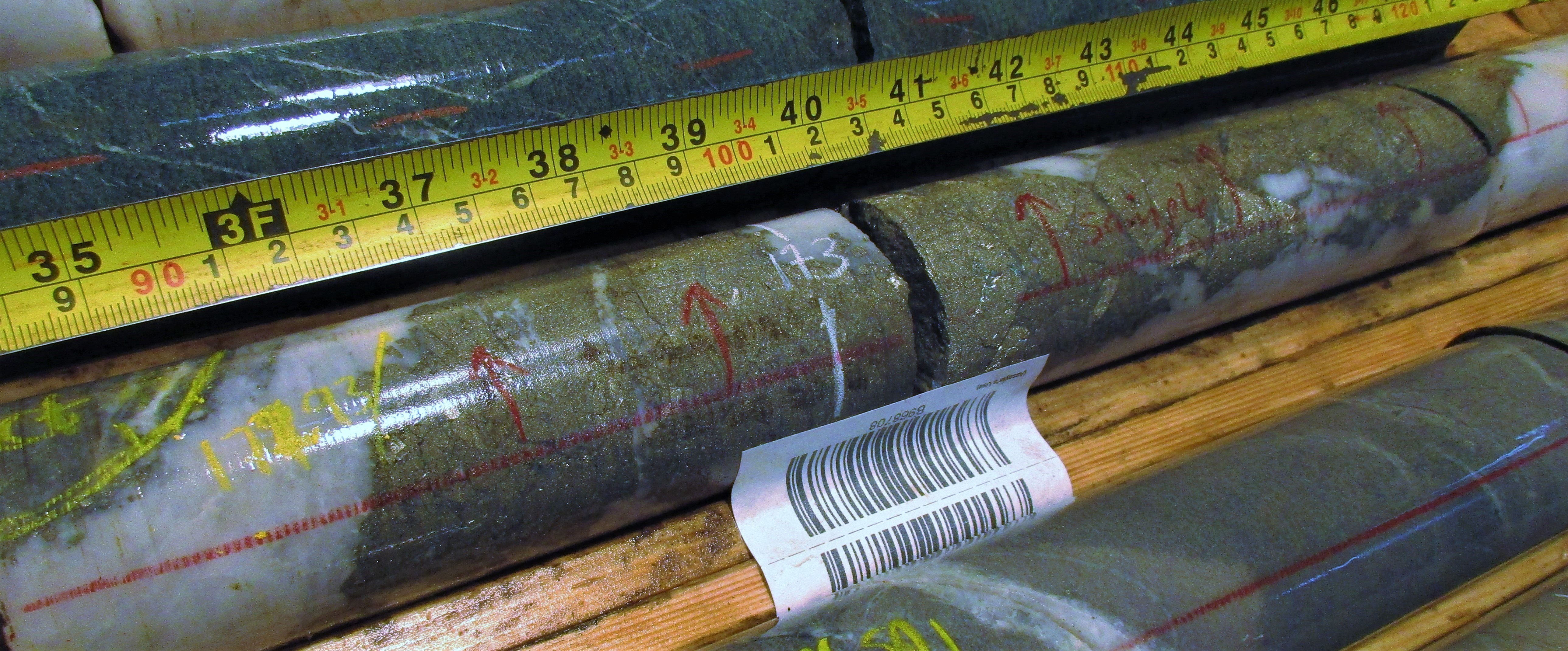
Figure 2: Hole 14 (ACP-R-210014) at 173.0 metres showing semi-massive sulphide intersection contained within newly intersected fourth quartz-carbonate veining zone.
To view an enhanced version of Figure 2, please visit:
https://orders.newsfilecorp.com/files/6963/84624_b36f0fab243e2acc_002full.jpg
Drill hole locations for holes 1 through 15 are shown below relative to the Rickard mine workings (see Figure 3) and can be seen on the Company's website on the Rickard project page. The ongoing phase 1 program is designed to identify the orientation of mineralization and determine if it can be traced to additional mineralized zones that have yet to be discovered.

Figure 3. Rickard 3D Model showing phase 1 Drill Holes 1 through 15 (ACP-R-21001 to ACP-R-21015) and the limit of historic mine workings.
To view an enhanced version of Figure 3, please visit:
https://orders.newsfilecorp.com/files/6963/84624_b36f0fab243e2acc_003full.jpg

Figure 4: Hole 11 (ACP-R-21011) at 163.0 metres showing mineralized shear-parallel quartz carbonate vein with perpendicular extensional tension gashes/growth fabric.
To view an enhanced version of Figure 4, please visit:
https://orders.newsfilecorp.com/files/6963/84624_b36f0fab243e2acc_004full.jpg
Results from the phase 1 program will be incorporated into the Company's expanding 3D project model providing a better understanding of the geological and structural controls on mineralization and will enable the Company to plan for a potential ramped up phase 2 program.
Initial results are anticipated to be released as they become available within the coming month. Additional pictures of the core have also been uploaded to the Company's website on the Rickard Gold Project page.
The Property covers a prospective 5,656 hectares of the Abitibi Greenstone Belt located approximately 70 kilometres from the town of Timmins in the Timmins Gold Camp which has produced over 80 million ounces of gold over the last 100 years. The Property is road accessible and sits within 25 to 60 kilometers of six currently producing gold mines and eight previous producers. Large areas of the Property remain untested and under cover.
Disclosure
Apparent widths of veins intersected are estimated to be 90% of true widths in holes ACP-R-21015, 80% in hole ACP-R-21013, and 70% in hole ACP-R-21014.
Adrian Smith, P.Geo., is a QP as defined by National Instrument 43-101 for the above-mentioned project. The QP is a member in good standing of the Professional Geoscientists Ontario (PGO) and is a registered Professional Geoscientist (P.Geo.). Mr. Smith has reviewed and approved the technical information disclosed above.
About ArcPacific Resources Corp.
ArcPacific Resources Corp. (TSXV: ACP) is a Canadian based exploration company expanding the exploration initiative at multiple historic past producing gold and silver mines in the Timmins Gold Camp, Ontario, and in the Nicola Mining Division in Southern British Columbia. The Company is focused on creating shareholder value through new discoveries and strategic development of its mineral properties. For further information, please visit http://www.arcpacific.ca.
ON BEHALF OF THE BOARD OF DIRECTORS
/S "Adrian Smith"
CEO and Director
The forward-looking statements contained in this press release are made as of the date hereof and ArcPacific Resources Corp. undertakes no obligations to update publicly or revise any forward-looking statements or information, whether as a result of new information, future events or otherwise, unless so required by applicable securities laws.
Neither the TSX Venture Exchange nor its Regulation Service Provider (as that term is defined in the policies of the TSX Venture Exchange) accepts responsibility for the adequacy or accuracy of this release.
For further information, please contact us at info@arcpacific.ca or 1.778.331.3816.
![]()
To view the source version of this press release, please visit https://www.newsfilecorp.com/release/84624