Thunder Bay, Ontario--(Newsfile Corp. - May 10, 2021) - Kesselrun Resources Ltd. (TSXV: KES) (OTC Pink: KSSRF) ("Kesselrun" or the "Company") is pleased to provide the following drilling results on its Huronian Gold Project.
The first set of holes drilled on the McKellar Zone in 2021 program has been successful in extending the mineralized shoot to over 75 metres in vertical depth with multiple high-grade zones over significant widths within a wider zone of significant gold mineralization.
Highlights
21HUR056 intercepted 7.2 g/t Au over 5.8 m, 3.3 g/t Au over 5.3 m and 4.7 g/t Au over 3.1 m all within a 67.8 m wide zone which averaged 1.6 g/t Au
21HUR057 intercepted 5.5 g/t Au over 4.7 m within a 23.0 m wide zone which averaged 1.4 g/t Au

Figure 1: Schematic Longsection - McKellar Zone
To view an enhanced version of Figure 1, please visit:
https://orders.newsfilecorp.com/files/4206/83246_figure1.jpg
Michael Thompson, P.Geo., President and CEO of the Company, commented, "These initial holes on McKellar in 2021 have confirmed the model developed after last year's drilling. The next phase of drilling at McKellar will focus on outlining further high-grade shoots and extending mineralization down plunge."
The 2021 Huronian drill program is budgeted at 20,000 metres targeting the Fisher, Fisher North, McKellar and Huronian zones, all in close proximity along an approximate 1500 m strike length in the area of the historic Huronian Mine. As of this news release approximately 6500 metres has been drilled of which 2750 metres of drilling results have been released. The area also has tremendous potential for discovery of new wide zones of significant gold mineralization in light of the new revised mineralization model.
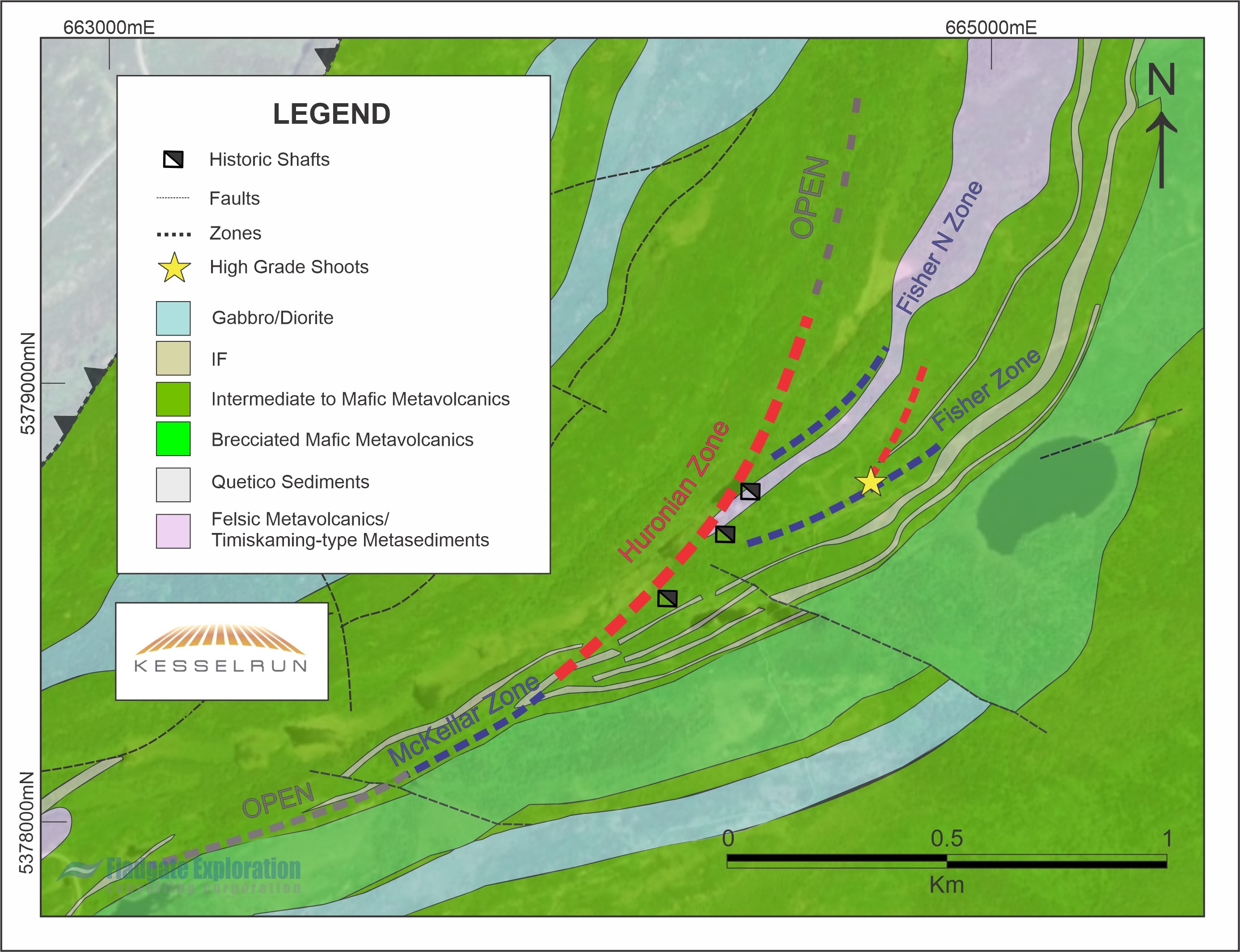
Figure 2: Schematic Plan Map - Huronian Project
To view an enhanced version of Figure 2, please visit:
https://orders.newsfilecorp.com/files/4206/83246_535156d7d44f5981_002full.jpg
Table 1: Summary of Significant Drill Intercepts - Current News Release (1)
| Hole ID | Zone | From (m) | To (m) | Interval (m) | Au (g/t) |
| 21HUR056 | McKellar | 17.7 | 85.5 | 67.8 | 1.6 |
| including | 18.0 | 19.8 | 1.8 | 5.2 | |
| including | 43.9 | 85.5 | 41.6 | 2.2 | |
| and including | 63.7 | 66.8 | 3.1 | 4.7 | |
| and including | 72.7 | 78.0 | 5.3 | 3.3 | |
| and including | 79.7 | 85.5 | 5.8 | 7.2 | |
| and including | 79.7 | 83.3 | 3.6 | 9.0 | |
| 21HUR057 | McKellar | 13.9 | 36.9 | 23.0 | 1.4 |
| including | 31.7 | 36.4 | 4.7 | 5.5 | |
| 21HUR058 | McKellar | 82.7 | 83.0 | 0.3 | 5.4 |
| 83.0 | stope | ||||
| 21HUR059 | McKellar | 87.0 | 105.6 | 18.6 | 1.1 |
| including | 90.0 | 91.0 | 1.0 | 7.7 | |
| including | 93.6 | 94.6 | 1.0 | 6.3 | |
Table 2: Summary of Significant Drill Intercepts - 2021 Huronian Project (1)
| Hole ID | Zone | From (m) | To (m) | Interval (m) | Au (g/t) |
| 21HUR030 | Fisher | 10.6 | 51.8 | 41.2 | 1.4 |
| including | 33.0 | 43.3 | 10.3 | 4.7 | |
| and including | 33.0 | 34.0 | 1.0 | 14.8 | |
| 21HUR031 | Fisher | 21.5 | 44.2 | 22.7 | 2.1 |
| including | 28.0 | 33.8 | 5.8 | 6.8 | |
| and including | 30.0 | 31.0 | 1.0 | 30.4 | |
| 21HUR032 | Fisher | 25.1 | 56.6 | 31.5 | 1.9 |
| including | 25.1 | 29.7 | 4.6 | 5.6 | |
| and including | 25.4 | 28.7 | 3.3 | 6.2 | |
| including | 46.2 | 50.1 | 3.9 | 4.5 | |
| and including | 49.2 | 50.1 | 0.9 | 14.3 | |
| 21HUR033 | Fisher | 22.6 | 30.2 | 7.6 | 1.4 |
| 21HUR034 | Fisher | 23.8 | 65.9 | 42.1 | 1.9 |
| including | 23.8 | 27.6 | 3.8 | 5.8 | |
| and including | 23.8 | 24.6 | 0.8 | 16.7 | |
| including | 52.6 | 56.5 | 3.9 | 7.0 | |
| and including | 52.6 | 54.0 | 1.4 | 13.3 | |
| 21HUR035 | Fisher | 25.0 | 66.9 | 41.9 | 0.7 |
| including | 27.9 | 29.9 | 2.0 | 4.4 | |
| 21HUR036 | Fisher | 46.7 | 62.0 | 15.3 | 0.7 |
| including | 49.4 | 50.4 | 1.0 | 3.8 | |
| 21HUR037 | Fisher | 114.0 | 117.5 | 3.5 | 15.6 |
| including | 117.0 | 117.5 | 0.5 | 99.0 | |
| 21HUR038 | Fisher | 91.3 | 92.2 | 0.9 | 2.5 |
| 21HUR039 | Fisher | 2.3 | 23.3 | 21.0 | 0.9 |
| including | 7.2 | 8.9 | 1.7 | 5.4 | |
| 21HUR040 | Fisher | 34.4 | 34.8 | 0.4 | 8.0 |
| Huronian | 262.8 | 263.4 | 0.6 | stope | |
| Huronian | 263.4 | 266.3 | 2.9 | 7.3 | |
| including | 263.4 | 263.9 | 0.5 | 34.2 | |
| 21HUR041 | lost hole | ||||
| 21HUR042 | Fisher | 14.5 | 17.8 | 3.3 | 5.3 |
| including | 16.9 | 17.8 | 0.9 | 17.0 | |
| 21HUR043 | nsv | ||||
| 21HUR044 | Fisher | 92.4 | 108.5 | 16.1 | 1.1 |
| including | 103.0 | 104.0 | 1.0 | 5.8 | |
| 21HUR045 | Fisher | 90.4 | 91.0 | 0.6 | 5.9 |
| 21HUR046 | Fisher | 70.4 | 71.4 | 1.0 | 2.9 |
| 21HUR047 | Fisher N | nsv | |||
| 21HUR048 | Fisher N | lost hole - redrilled as 049 | |||
| 21HUR049 | Fisher N | nsv | |||
| 21HUR050 | Huronian | lost hole - redrilled as 051 | |||
| 21HUR051 | Huronian | hit stope | |||
| 21HUR052 & 053 | results pending | ||||
| 21HUR054 | Huronian | 115.4 | 119.5 | 4.1 | 16.2 |
| including | 115.4 | 116.0 | 0.6 | 81.5 | |
| 21HUR055 | results pending | ||||
(1) Widths are drill indicated core length as insufficient drilling has been undertaken to determine true widths at this time. Average grades are calculated with un-capped gold assays as insufficient drilling has been completed to determine capping levels for higher grade gold intercepts.
About the Huronian Gold Project
The 100% owned Huronian Gold Project hosts the past producing Huronian Mine, Northwestern Ontario's first gold mine with an historic resource estimate of 44,592 oz Au at an average grade of 15.3 g/t Au in the indicated category and 501,377 oz Au at an average grade of 14.4 g/t Au in the inferred category. The resource estimate presented for the Huronian Project is historic in nature. Kesselrun Resources' qualified person has not completed sufficient work to confirm the results of the historical resource. Kesselrun Resources is not treating this as a current mineral resource but is considering it relevant as a guide to future exploration and is included for reference purposes only. The historic resource was estimated by Minescape Exploration Inc. in 1998. Further drilling will be required by Kesselrun Resources to verify the historic estimate as current mineral resources.
As well, the Huronian Gold Project hosts the same lithological package of rocks, as interpreted from both Government of Ontario and Kesselrun Resources mapping, compilation and modelling, on strike from Wesdome Gold's adjacent Moss Lake Gold Deposit with a resource estimate of 1,377,300 oz Au at an average grade of 1.1 g/t Au in the indicated category and 1,751,600 oz Au at an average grade of 1.1 g/t Au in the inferred category as outlined in their 2013 PEA2. Mineralization hosted on adjacent and/or nearby properties is not necessarily indicative of mineralization hosted on Kesselrun Resources' property.
(2)Moss Lake Gold Mines (currently wholly owned subsidiary of Wesdome Gold) news releases February 20, 2013 and September 9, 2013.
On January 26, 2021 Wesdome announced that the Moss Lake Project would be purchased by Goldshore Resources Inc. (see Wesdome and Goldshore news releases dated January 26, 2021).
Qualified Person
Michael Thompson, P.Geo., President and CEO of Kesselrun, is the Qualified Person responsible for the project as defined by National Instrument 43-101 and has approved the technical information in this news release.
QAQC
Kesselrun has implemented a quality control program to comply with industry best practices for sampling, chain of custody and analyses. Certified gold reference standards, blanks and duplicates are inserted at the core processing site as part of the QA/QC program in addition to the control samples inserted by the lab. Samples are prepared and analyzed by Activation Laboratories in Thunder Bay. Samples are analyzed for gold using Fire Assay-AA techniques. Samples returning over 10 g/t gold are analyzed using Fire Assay-Gravimetric methods. Selected samples are also analyzed with a standard 1 kg metallic screen fire assay. All results reported herein have passed QA/QC protocols.
Health and Safety
The health and safety of our personnel and contractors is always top priority to Kesselrun. The current situation presents new challenges above and beyond what we normally face while working in the field. Kesselrun has implemented further measures to ensure the health and safety of all working on the Company's projects.
About Kesselrun Resources Ltd.
Kesselrun Resources is a Thunder Bay, Ontario-based mineral exploration company focused on growth through property acquisitions and discoveries. Kesselrun's management team possesses strong geological and exploration expertise in Northwest Ontario. For more information about Kesselrun Resources, please visit www.kesselrunresources.com.
Neither the TSX Venture Exchange nor its Regulation Services Provider (as that term is defined in the policies of the TSX Venture Exchange) accepts responsibility for the adequacy or accuracy of this news release.
For additional information please contact:
Kesselrun Resources Ltd.
Michael Thompson, P.Geo., President & CEO
807.285.3323
michaelt@kesselrunresources.com
Corporate Communications
1.866.416.7941
information@kesselrunresources.com
Forward Looking Statements - Certain information set forth in this news release may contain forward-looking statements that involve substantial known and unknown risks and uncertainties. These forward-looking statements are subject to numerous risks and uncertainties, certain of which are beyond the control of Kesselrun, including, but not limited to the impact of general economic conditions, industry conditions, volatility of commodity prices, dependence upon regulatory approvals, the execution of definitive documentation, the availability of financing and exploration risk. Readers are cautioned that the assumptions used in the preparation of such information, although considered reasonable at the time of preparation, may prove to be imprecise and, as such, undue reliance should not be placed on forward-looking statements.
![]()
To view the source version of this press release, please visit https://www.newsfilecorp.com/release/83246
Source: Kesselrun Resources Ltd.