Road Town, Tortola, British Virgin Islands--(Newsfile Corp. - March 31, 2021) - Talon Metals Corp. (TSX: TLO) ("Talon" or the "Company") is pleased to provide an update on the Tamarack Nickel-Copper-Cobalt Project ("Tamarack Nickel Project"), located in Minnesota, USA. The Tamarack Nickel Project comprises the Tamarack North Project and the Tamarack South Project.
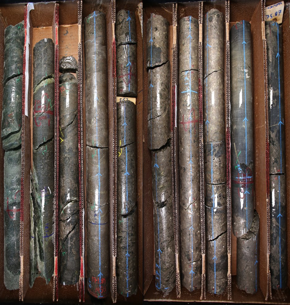
Figure 1: 5.1 Meters (16.7 feet) of Mixed Massive Sulphide Mineralization starting at 171.26 meters (Drill Hole 21TK0283).
To view an enhanced version of Figure 1, please visit:
https://orders.newsfilecorp.com/files/2443/78996_9b642679140bc83a_001full.jpg
HIGHLIGHTS
Talon has consistently intersected massive sulphide mineralization at shallow depths in a new area that extends to approximately 700 meters north-east of the Tamarack Nickel Project's resource area (known as CGO East). More specifically:
Drill hole 21TK0283 intersected 34.34 meters (112.6 feet) of nickel-copper mineralization starting at 142 meters, including 5.1 meters (16.7 feet) of mixed and massive sulphide mineralization starting at 171.26 meters;
Drill hole 21TK0288 intersected 20.9 meters (68.6 feet) of nickel-copper mineralization starting at 148.6 meters, including 0.71 meters (2.3 feet) of mixed and massive sulphide starting at 168.79 meters;
Drill hole 21TK0289 intersected 30.42 meters (99.8 feet) of nickel-copper mineralization starting at 181.52 meters, including 1.88 meters (6.2 feet) of mixed and massive sulphide mineralization starting at 210.06 meters;
Drill hole 21TK0290 intersected 27.18 meters (89.1 feet) of nickel-copper mineralization starting at 151.79 meters, including 1.6 meters (5.2 feet) of mixed and massive sulphide mineralization starting at 183.13 meters;
Drill hole 21TK0291 intersected 13.91 meters (45.6 feet) of nickel-copper mineralization starting at 210.61 meters, including 1.86 meters (6.1 feet) of mixed and massive sulphide mineralization starting at 183.13 meters;
Drill hole 21TK0294 intersected 16.3 meters (53.5 feet) of nickel-copper mineralization starting at 213.9 meters, including 0.58 meters (1.9 feet) of mixed massive sulphide starting at 230.57 meters;
Drill hole 21TK0295 intersected 25.01 meters (82.0 feet) of nickel-copper mineralization starting at 140.15 meters, including 4.32 meters (14.1 feet) of mixed and massive sulphide mineralization starting at 160.84 meters; and,
Drill hole 21TK0296 intersected 20.3 meters (66.6 feet) of nickel-copper mineralization starting at 190 meters, including 1.6 meters (5.24 feet) of mixed and massive sulphide mineralization starting at 208.7 meters.
- This new area has been a recent focus for Talon because if a resource can ultimately be delineated, this could potentially add significant tonnage to the current resource and mine plan, and also potentially increase the mine life of the Tamarack Nickel Project.
"The consistent drilling success we are seeing in the CGO East area, which so far, extends approximately 700 meters north-east of the Tamarack Nickel Project's resource area, is just another example of how geophysics has proven to be an excellent tool for identifying additional nickel-copper mineralization at the Tamarack Nickel Project. So far, we are drilling what appears to be a continuous sheet of shallow mineralization in a new zone outside of our current resource area. This CGO East area will continue to be a focus for Talon's drilling program, as we look to delineate a brand new resource over the coming months," said Brian Goldner, Head of Exploration for Talon.
"The CGO East area, together with the other areas we have recently successfully explored towards the north of our resource area, could all potentially contribute to higher production tonnages per day, while potentially reducing the ultimate timeline to production and lengthening the mine life at the Tamarack Nickel Project. These factors all drive value," said Vince Conte, CFO of Talon.
SUMMARY
The CGO East target area is large, stretching over an area of 500 meters (east-west) by 900 meters (north-south) outside of the Tamarack Nickel Project's resource area (See Talon's press release dated November 2, 2020 for details).
Surface and Borehole Electro-Magnetic ("EM") surveys (geophysics) showed a potential for this area to host shallow, wide sheets of mineralization. In the summer of 2020, Talon began by drilling 4 successful holes in this new area (see Table 1 below for assays received to date). Since then, Talon has followed up with additional drilling with the following positive results (all assays pending):
- Drill hole 21TK0283 intersected 34.34 meters (112.6 feet) of nickel-copper mineralization starting at 142 meters, including 5.1 meters (16.7 feet) of mixed and massive sulphide mineralization starting at 171.26 meters;
- Drill hole 21TK0288 intersected 20.9 meters (68.6 feet) of nickel-copper mineralization starting at 148.6 meters, including 0.71 meters (2.3 feet) of mixed massive sulphide starting at 168.79 meters;
- Drill hole 21TK0289 intersected 30.42 meters (99.8 feet) of nickel-copper mineralization starting at 181.52 meters, including 1.88 meters (6.2 feet) of mixed and massive sulphide mineralization starting at 210.06 meters;
- Drill hole 21TK0290 intersected 27.18 meters (89.1 feet) of nickel-copper mineralization starting at 151.79 meters, including 1.6 meters (5.2 feet) of mixed and massive sulphide mineralization starting at 183.13 meters;
- Drill hole 21TK0291 intersected 12.13 meters (39.8 feet) of nickel-copper mineralization starting at 210.61 meters, including 1.86 meters (6.1 feet) of mixed and massive sulphide mineralization starting at 222.74 meters;
- Drill hole 21TK0294 intersected 16.3 meters (53.5 feet) of nickel-copper mineralization starting at 213.9 meters, including 0.58 meters (1.9 feet) of mixed massive sulphide starting at 230.57 meters;
- Drill hole 21TK0295 intersected 25.01 meters (82.0 feet) of nickel-copper mineralization starting at 140.15 meters, including 4.32 meters (14.1 feet) of mixed and massive sulphide mineralization starting at 160.84 meters; and,
- Drill hole 21TK0296 intersected 20.3 meters (66.6 feet) of nickel-copper mineralization starting at 190 meters, including 1.6 meters (5.24 feet) of mixed and massive sulphide mineralization starting at 208.7 meters.
So far, these results are confirming the initial continuous trend of nickel-copper mineralization that was modelled by Talon from the surface and borehole EM data (geophysics). Drill results thus far (for which assays have already been received) show a consistent pattern that begins with a large, shallow intercept of disseminated sulphide mineralization above a sheet of higher-grade massive sulphide mineralization.
Talon plans to continue drilling this large area with the goal of delineating a resource that could be added to the current mine plan.
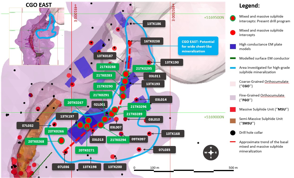
Figure 2: Plan view map of the CGO East mineralization. The solid blue line shows the potential extent of the sulphide mineralization in the area. The dashed red line represents an approximate 800 meter trend.
To view an enhanced version of Figure 2, please visit:
https://orders.newsfilecorp.com/files/2443/78996_9b642679140bc83a_002full.jpg
Table 1: Assays from the Initial Four Drill Holes within the CGO East Target Area
| Drill Hole | From | To | Length | Results | |||||||
| # | (m) | (m) | (m) | Ni (%) | Cu (%) | Co (%) | Pd (g/t) | Pt (g/t) | Au (g/t) | NiEq (%) | CuEq (%) |
| 20TK0266 | 203 | 236 | 33 | No significant mineralization | |||||||
| 20TK0266 | 236 | 247.75 | 11.75 | 1.03 | 0.72 | 0.03 | 0.14 | 0.31 | 0.25 | 1.5 | 3.99 |
| including | 246.5 | 247.75 | 1.25 | 2.3 | 1.09 | 0.09 | 0.15 | 0.27 | 0.3 | 2.99 | 7.96 |
| 20TK0267 | 224.33 | 249.02 | 24.69 | Assays pending | |||||||
| 20TK0268 | 287.12 | 312.59 | 25.07 | Assays pending | |||||||
| 20TK0271 | 236 | 245.55 | 9.55 | 2.12 | 0.97 | 0.06 | 0.14 | 0.28 | 0.23 | 2.71 | 7.22 |
| including | 242.84 | 245.55 | 2.71 | 5.13 | 1.70 | 0.16 | 0.20 | 0.35 | 0.21 | 6.15 | 16.41 |
Length refers to drill hole length and not True Width.
True Width is unknown at the time of publication.
All samples were analysed by ALS Minerals. Nickel, copper, and cobalt grades were first analysed by a 4-acid digestion and ICP AES (ME-MS61). Grades reporting greater than 0.25% Ni and/or 0.1% Cu, using ME-MS61, trigger a sodium peroxide fusion with ICP-AES finish (ICP81). Platinum, palladium and gold are initially analyzed by a 50g fire assay with an ICP-MS finish (PGM-MS24). Any samples reporting >1g/t Pt or Pd trigger an over-limit analysis by ICP-AES finish (PGM-ICP27) and any samples reporting >1g/t Au trigger an over-limit analysis by AAS (Au-AA26).
NiEq% = Ni%+ Cu% x $3.00/$8.00 + Co% x $12.00/$8.00 + Pt [g/t]/31.103 x $1,300/$8.00/22.04 + Pd [g/t]/31.103 x $700/$8.00/22.04 + Au [g/t]/31.103 x $1,200/$8.00/22.04.
CuEq% = Cu%+ Ni% x $8.00/$3.00 + Co% x $12.00/$3.00 + Pt [g/t]/31.103 x $1,300/$3.00/22.04 + Pd [g/t]/31.103 x $700/$3.00/22.04 + Au [g/t]/31.103 x $1,200/$3.00/22.04.
No adjustments were made for recovery or payability.
QUALITY ASSURANCE, QUALITY CONTROL AND QUALIFIED PERSONS
Please see the technical report entitled "NI 43-101 Technical Report Updated Preliminary Economic Assessment (PEA) #3 of the Tamarack North Project - Tamarack, Minnesota" with an effective date of January 8, 2021 prepared by independent "Qualified Persons" (as that term is defined in National Instrument 43-101 ("NI 43-101") Leslie Correia (Pr. Eng), Andre-Francois Gravel (P. Eng.), Tim Fletcher (P. Eng.), Daniel Gagnon (P. Eng.), David Ritchie (P. Eng.), Oliver Peters (P. Eng.), Volodymyr Liskovych (P.Eng.), Andrea Martin (P. E.) and Brian Thomas (P. Geo.) for information on the QA/QC, analytical and testing procedures at the Tamarack Project. Copies are available on the Company's website (www.talonmetals.com) or on SEDAR at (www.sedar.com). The laboratory used is ALS Minerals who is independent of the Company.
Lengths are drill intersections and not necessarily true widths. True widths cannot be consistently calculated for comparison purposes between holes because of the irregular shapes of the mineralized zones. Drill intersections have been independently selected by Talon. Drill composites have been independently calculated by Talon. The geological interpretations in this news release are solely those of the Company.
The locations and distances highlighted on all maps in this news release are approximate.
Dr. Etienne Dinel, Vice President, Geology of Talon, is a Qualified Person within the meaning of NI 43-101. Dr. Dinel is satisfied that the analytical and testing procedures used are standard industry operating procedures and methodologies, and he has reviewed, approved and verified the technical information disclosed in this news release, including sampling, analytical and test data underlying the technical information.
ABOUT TALON
Talon is a TSX-listed base metals company in a joint venture with Rio Tinto on the high-grade Tamarack Nickel-Copper-Cobalt Project located in Minnesota, USA, comprised of the Tamarack North Project and the Tamarack South Project. Talon has an earn-in to acquire up to 60% of the Tamarack Project. The Tamarack Project comprises a large land position (18km of strike length) with numerous high-grade intercepts outside the current resource area. Talon is focused on expanding its current high-grade nickel mineralization resource prepared in accordance with NI 43-101; identifying additional high-grade nickel mineralization; and developing a process to potentially produce nickel sulphates responsibly for batteries for the electric vehicles industry. Talon has a well-qualified exploration and mine management team with extensive experience in project management.
For additional information on Talon, please visit the Company's website at www.talonmetals.com or contact:
Sean Werger
President
Talon Metals Corp.
Tel: (416) 361-9636 x102
Email: werger@talonmetals.com
FORWARD-LOOKING STATEMENTS
This news release contains certain "forward-looking statements". All statements, other than statements of historical fact that address activities, events or developments that the Company believes, expects or anticipates will or may occur in the future are forward-looking statements. These forward-looking statements reflect the current expectations or beliefs of the Company based on information currently available to the Company. Such forward-looking statements include statements relating to the timing and results of the exploration program, including assay results, grades, potential and results, and drilling plans; the potential to add significant tonnage to the current resource and mine plan; the potential to increase the mine life of the Tamarack Nickel Project; the likelihood of a continuous sheet of shallow mineralization outside of the Company's current resource area; the likelihood of delineating a brand new resource over the coming months; the potential for higher production tonnages per day, while potentially reducing the ultimate timeline to production and lengthening the mine life at the Tamarack Nickel Project. Forward-looking statements are subject to significant risks and uncertainties and other factors that could cause the actual results to differ materially from those discussed in the forward-looking statements, and even if such actual results are realized or substantially realized, there can be no assurance that they will have the expected consequences to, or effects on the Company.
Any forward-looking statement speaks only as of the date on which it is made and, except as may be required by applicable securities laws, the Company disclaims any intent or obligation to update any forward-looking statement, whether as a result of new information, future events or results or otherwise. Although the Company believes that the assumptions inherent in the forward-looking statements are reasonable, forward-looking statements are not guarantees of future performance and accordingly undue reliance should not be put on such statements due to the inherent uncertainty therein.
Table 2: Collar Locations of Drill Holes Referred to in this Press Release
| CGO EAST | ||||||
| HOLE ID | Easting (m) | Northing (m) | Elevation (masl) | Azm | Dip | End Depth (m) |
| 21TK0283 | 491303.8 | 5169144.8 | 388.0 | 259.2 | -78.0 | 203.3 |
| 21TK0288 | 491298.5 | 5169148.4 | 388.0 | 311.9 | -75.2 | 198.3 |
| 21TK0289 | 491178.0 | 5168988.0 | 388.0 | 23.6 | -79.5 | 233.9 |
| 21TK0290 | 491300.3 | 5169144.9 | 388.0 | 214.1 | -71.8 | 209.7 |
| 21TK0291 | 491178.2 | 5168985.8 | 388.0 | 237.5 | -80.1 | 247.5 |
| 21TK0294 | 491178.0 | 5168985.0 | 388.0 | 222.3 | -72.9 | 301.1 |
| 21TK0295 | 491294.0 | 5169149.9 | 388.0 | 345.3 | -67.3 | 188.5 |
| 21TK0296 | 491176.0 | 5168998.0 | 388.0 | 49.5 | 73.9 | 236.7 |
| 20TK0266 | 491022.0 | 5168949.1 | 388.0 | 110.0 | -82.5 | 283.5 |
| 20TK0267 | 491021.2 | 5168949.1 | 388.0 | 78.7 | -70.1 | 295.5 |
| 20TK0268 | 491021.9 | 5168951.8 | 388.0 | 218.1 | -66.2 | 388.8 |
| 20TK0271 | 491019.0 | 5168955.0 | 388.0 | 111.0 | -78.5 | 299.6 |
Collar coordinates are UTM Zone 15N, NAD83.
Azimuths and dips are taken from survey record at collar unless otherwise noted.
* No record of collar azimuth and dip. First record of downhole survey used.
Table 3: Quick Lithology Log for Recent Drill Holes in the CGO East Target Area
| Hole ID | From (m) | To (m) | Length (m) | Lithology | % Sulphides |
| 21TK0283 | 0 | 42.37 | 42.37 | Overburden | |
| 42.37 | 142 | 99.63 | FGO/MZNO | Traces | |
| 142 | 171.26 | 29.26 | FGO/MZNO | 5 to 7% | |
| 171.26 | 176.34 | 5.08 | MMS/MSU | 15-85% | |
| 176.34 | 203.3 | 26.96 | SED | ||
| 21TK0288 | 0 | 43.89 | 43.89 | Overburden | |
| 43.89 | 148.6 | 104.71 | FGO/MZNO | Traces | |
| 148.6 | 168.79 | 20.19 | FGO/MZNO | tr-8% | |
| 168.79 | 169.5 | 0.71 | MMS | 50% | |
| 169.5 | 198.27 | 28.77 | SED | ||
| 21TK0289 | 0 | 45.42 | 45.42 | Overburden | |
| 45.42 | 181.52 | 136.1 | FGO/MZNO | Traces | |
| 181.52 | 210.06 | 28.54 | FGO/MZNO | tr-4% | |
| 210.06 | 211.94 | 1.88 | MSU | 85% | |
| 211.94 | 233.93 | 21.99 | SED | ||
| 21TK0290 | 0 | 44.2 | 44.2 | Overburden | |
| 44.2 | 151.79 | 107.59 | FGO/MZNO | Traces | |
| 151.79 | 178.97 | 27.18 | FGO/MZNO | 7% | |
| 178.97 | 183.13 | 4.16 | FGO/MZNO | 1% | |
| 183.13 | 184.73 | 1.6 | MMS/MSU | 40-90% | |
| 184.73 | 209.7 | 24.97 | SED | ||
| 21TK0291 | 0 | 44.2 | 44.2 | Overburden | |
| 44.2 | 210.61 | 166.41 | FGO/MZNO | Tr-3% | |
| 210.61 | 222.74 | 12.13 | FGO/MZNO | 5-15% | |
| 222.74 | 224.6 | 1.86 | MMS/MSU | 25% | |
| 224.6 | 247.5 | 22.9 | SED | ||
| 21TK0294 | 0 | 44.3 | 44.3 | Overburden | |
| 44.3 | 213.9 | 169.6 | FGO/MZNO | Tr-2% | |
| 213.9 | 230.2 | 16.3 | FGO/MZNO | 3-6% | |
| 230.2 | 230.57 | 0.37 | SED | ||
| 230.57 | 231.15 | 0.58 | MMS/MSU | 15% | |
| 231.15 | 301.14 | 69.99 | SED | ||
| 21TK0295 | 0 | 44.81 | 44.81 | Overburden | |
| 44.81 | 140.15 | 95.34 | FGO/MZNO | tr | |
| 140.15 | 160.84 | 20.69 | FGO/MZNO | 2-5% | |
| 160.84 | 165.16 | 4.32 | MMS | 15-70% | |
| 165.16 | 185.32 | 20.16 | SED | ||
| 21TK0296 | 0 | 44.2 | 44.2 | Overburden | |
| 44.2 | 180.25 | 136.05 | FGO/MZNO | Tr | |
| 180.25 | 190 | 9.75 | FGO/MZNO | 2% | |
| 190 | 208.7 | 18.7 | FGO/MZNO | 3-8% | |
| 208.7 | 210.3 | 1.6 | MMS/MSU | 50% | |
| 210.3 | 236.88 | 26.58 | SED |
To view the source version of this press release, please visit https://www.newsfilecorp.com/release/78996
Source: Talon Metals Corp.