Road Town, Tortola, British Virgin Islands--(Newsfile Corp. - November 24, 2020) - Talon Metals Corp. (TSX: TLO) ("Talon" or the "Company") is pleased to provide an update on the Tamarack Nickel-Copper-Cobalt Project ("Tamarack Project"), located in Minnesota, USA. The Tamarack Project comprises the Tamarack North Project and the Tamarack South Project.

Figure 1: Massive Sulphide Mineralization Starting at 414.73 meters
(Drill hole 20TK0273)
To view an enhanced version of Figure 1, please visit:
https://orders.newsfilecorp.com/files/2443/68808_34533b2534cfb878_001full.jpg
HIGHLIGHTS
- Drill hole 20TK0273 intersected 8.39 meters (27.53 feet) of high-grade massive sulphide mineralization starting at 414.73 meters as shown in Figures 1 and 2 (assays pending).
- Drill hole 20TK0273 was targeting a geophysical (BHEM) anomaly that was refined during the recent resurveying of historic drill hole 15TK0219.
- Results indicate an extension of mineralization to the north of historic intercepts of thick mineralization.
"We are excited by the results from this latest drill hole," said Brian Goldner, Head of Exploration. "The recent geophysical program that focused on running Borehole Electro-Magnetic surveys down existing boreholes has helped to refine off-hole anomalies into exciting new targets. The eastern limb of the high-grade Massive Sulphide Unit at the Tamarack Project has thick massive sulphide intercepts at both the north and south ends of the limb, but the middle had previously only produced thinner intercepts in historical drilling. With our high resolution BHEM we are able to show that the historic holes with thin intercepts in this zone have off-hole BHEM anomalies like the one drilled in 20TK0273, suggesting that there may be additional thick intercepts."
SUMMARY
Talon has continued the ongoing drill program at the Tamarack Project with three recent drill holes (see Figure 3 below) focusing on expanding the high-grade massive sulphide mineralization from the current resource area (see Figure 6 for a summary of the Company's current resource).
The recent geophysical program focused on running high resolution BHEM surveys with Talon's internal geophysical crew. Hole 15TK0219 was one of these holes that was resurveyed and produced an off-hole anomaly approximately 25 meters west of hole 15TK0219 (see Figure 4). Drill hole 20TK0273 was targeting the plate identified from the BHEM survey on 15TK0219 and intersected 8.39 metes (27.53 feet) of high-grade massive sulphide mineralization, starting at 414.73 meters (assays pending).
The BHEM program has identified off-hole BHEM anomalies along the 140 meter zone of massive sulphide mineralization within the Company's resource area that could potentially result in finding additional mineralization.
Drill hole 20TK0272 was also located along the eastern limb targeting a BHEM plate identified from drill hole 15TK0220A (see Figure 5) and intersected 22.12 meters (75.6 feet) of weak to moderate sulphide mineralization, starting at 385 meters, including 1.35 meters of mixed massive sulphides (assays pending). A BHEM survey down this hold has identiafied an off-hole BHEM anomaly for potential follow-up.
Drill hole 20TK0270 was testing a potential 150 meter extension from the current resource area on the western limb of the Massive Sulphide Unit ("MSU") and intersected a thin zone of mixed massive sulphides at the base of the intrusion.
Overall, results suggest the possibility of extending wide, massive mineralization to the north of drill hole 14TK0211.
Talon is now preparing for the arrival of a second drill rig to:
- Follow up on other MSU extensions south of the known resource where it is currently open; and
- Continue drilling to the north following up on new targets in the CGO Bend area (see the Company's press release dated November 2, 2020).
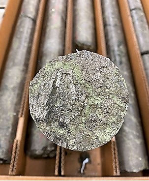
Figure 2: Massive Sulphide Mineralization from 414.73 meters TO 423.12 meters
(Drill hole 20TK0273)
To view an enhanced version of Figure 2, please visit:
https://orders.newsfilecorp.com/files/2443/68808_34533b2534cfb878_002full.jpg

Figure 3: Plan View Map of the Current Resource Area with Location of New Drill Holes. Segment A-A' Shows the Approximate Location of Cross-Section in Figure 4 and Segment B-B' Shows the Approximate Location of Longitudinal Section in Figure 5
To view an enhanced version of Figure 3, please visit:
https://orders.newsfilecorp.com/files/2443/68808_34533b2534cfb878_003full.jpg

Figure 4 Cross-Section Passing Through Drill Hole 20TK0273 Looking North
To view an enhanced version of Figure 4, please visit:
https://orders.newsfilecorp.com/files/2443/68808_34533b2534cfb878_004full.jpg

Figure 5: Longitudinal Section on the Western Massive Sulphide Unit Centered on Drill Hole 20TK0273 Looking East
To view an enhanced version of Figure 5, please visit:
https://orders.newsfilecorp.com/files/2443/68808_34533b2534cfb878_005full.jpg
| Domain | Resource Classification | Tonnes (000) | Ni (%) | Cu (%) | Co (%) | Pt (g/t) | Pd (g/t) | Au (g/t) | Calc NiEq (%) |
| SMSU | Indicated Resource | 3,639 | 1.83 | 0.99 | 0.05 | 0.42 | 0.26 | 0.2 | 2.45 |
| Total | Indicated Resource | 3,639 | 1.83 | 0.99 | 0.05 | 0.42 | 0.26 | 0.2 | 2.45 |
| SMSU | Inferred Resource | 1,107 | 0.90 | 0.55 | 0.03 | 0.22 | 0.14 | 0.12 | 1.25 |
| MSU | Inferred Resource | 570 | 5.86 | 2.46 | 0.12 | 0.68 | 0.51 | 0.25 | 7.24 |
| 138 Zone | Inferred Resource | 2,705 | 0.95 | 0.74 | 0.03 | 0.23 | 0.13 | 0.16 | 1.38 |
| Total | Inferred Resource | 4,382 | 1.58 | 0.92 | 0.04 | 0.29 | 0.18 | 0.16 | 2.11 |
All resources reported at a 0.83% NiEq cut-off.
No modifying factors have been applied to the estimates.
Tonnage estimates are rounded to the nearest 1,000 tonnes.
Metallurgical recovery factored into the reporting cut-off.
NiEq% = Ni%+ Cu% x $3.00/$8.00 + Co% x $12.00/$8.00 + Pt [g/t]/31.103 x $1,300/$8.00/22.04 + Pd [g/t]/31.103 x $700/$8.00/22.04 + Au [g/t]/31.103 x $1,200/$8.00/22.04
Figure 6: Current resource of the Tamarack North Project. Effective date of resource estimate February 15, 2018
QUALITY ASSURANCE, QUALITY CONTROL AND QUALIFIED PERSONS
Please see the technical report entitled "NI 43-101 Technical Report Updated Preliminary Economic Assessment (PEA) of the Tamarack North Project - Tamarack, Minnesota" with an effective date of March 12, 2020 prepared by independent "Qualified Persons" (as that term is defined in National Instrument 43-101 ("NI 43-101") Leslie Correia (Pr. Eng), Andre-Francois Gravel (P. Eng.), Tim Fletcher (P. Eng.), Daniel Gagnon (P. Eng.), David Ritchie (P. Eng.), Oliver Peters (P. Eng.), Christine Pint (P.G.) and Brian Thomas (P. Geo.) for information on the QA/QC, analytical and testing procedures at the Tamarack Project. Copies are available on the Company's website (www.talonmetals.com) or on SEDAR at (www.sedar.com). The laboratory used is ALS Minerals who is independent of the Company.
Lengths are drill intersections and not necessarily true widths. True widths cannot be consistently calculated for comparison purposes between holes because of the irregular shapes of the mineralized zones. Drill intersections have been independently selected by Talon. Drill composites have been independently calculated by Talon. The geological interpretations in this news release are solely those of the Company.
The locations and distances highlighted on all maps in this news release are approximate.
The Qualified Person who is responsible for the resource estimate in this news release is Mr. Brian Thomas, senior resource geologist at Golder Associates Ltd. and independent of Talon. Mr. Thomas has reviewed, approved and verified the data disclosed in this news release relating to the resource estimate including, sampling, analytical and test data underlying the resource estimate and has visited the site and reviewed and verified the QA/QC procedures used at the Tamarack Project and found them to be consistent with industry standards.
Dr. Etienne Dinel, Vice President, Geology of Talon, is a Qualified Person within the meaning of NI 43-101. Dr. Dinel is satisfied that the analytical and testing procedures used are standard industry operating procedures and methodologies, and he has reviewed, approved and verified the technical information disclosed in this news release (other than the resource estimate), including sampling, analytical and test data underlying the technical information.
ABOUT TALON
Talon is a TSX-listed base metals company in a joint venture with Rio Tinto on the high-grade Tamarack Nickel-Copper-Cobalt Project located in Minnesota, USA, comprised of the Tamarack North Project and the Tamarack South Project. Talon has an earn-in to acquire up to 60% of the Tamarack Project. The Tamarack Project comprises a large land position (18km of strike length) with numerous high-grade intercepts outside the current resource area. Talon is focused on expanding its current high-grade nickel mineralization resource prepared in accordance with NI 43-101; identifying additional high-grade nickel mineralization; and developing a process to potentially produce nickel sulphates responsibly for batteries for the electric vehicles industry. Talon has a well-qualified exploration and mine management team with extensive experience in project management.
For additional information on Talon, please visit the Company's website at www.talonmetals.com or contact:
Sean Werger
President
Talon Metals Corp.
Tel: (416) 361-9636 x102
Email: werger@talonmetals.com
FORWARD-LOOKING STATEMENTS
This news release contains certain "forward-looking statements". All statements, other than statements of historical fact that address activities, events or developments that the Company believes, expects or anticipates will or may occur in the future are forward-looking statements. These forward-looking statements reflect the current expectations or beliefs of the Company based on information currently available to the Company. Such forward-looking statements include statements relating to the timing and results of the exploration program, including assay results, grades, geophysical results and potential, drilling plans and the use of a second drill rig; the potential to extend mineralization and the potential for additional thick mineralization. Forward-looking statements are subject to significant risks and uncertainties and other factors that could cause the actual results to differ materially from those discussed in the forward-looking statements, and even if such actual results are realized or substantially realized, there can be no assurance that they will have the expected consequences to, or effects on the Company.
Any forward-looking statement speaks only as of the date on which it is made and, except as may be required by applicable securities laws, the Company disclaims any intent or obligation to update any forward-looking statement, whether as a result of new information, future events or results or otherwise. Although the Company believes that the assumptions inherent in the forward-looking statements are reasonable, forward-looking statements are not guarantees of future performance and accordingly undue reliance should not be put on such statements due to the inherent uncertainty therein.
To view the source version of this press release, please visit https://www.newsfilecorp.com/release/68808
Source: Talon Metals Corp.