
Helium anomalies concentrate within 1.5 km of faults F-I, F-II and F-III • A 10 km × 2 km magnetic intrusive body imaged beneath Zones B and C along F-III • Seismic program expanded to approximately 50 km • C1-C4 hydrocarbon results being interpreted
Montréal, Québec--(Newsfile Corp. - September 28, 2026) - Québec Innovative Materials Corp. (CSE: QIMC) (OTCQB: QIMCF) (FSE: 7FJ) ("QIMC" or the "Company") today reports the integrated geophysical interpretation of the helium zones announced on September 22, 2026 at its New Salem-Apple River area, Cumberland Basin Project, Nova Scotia. Working with Professor Marc Richer-Laflèche, Ph.D., of the Institut national de la recherche scientifique (INRS), the Company has integrated the 526-sample helium survey with regional gravity and aeromagnetic data and finds that the helium zones, the mapped faults and the buried basement architecture describe a single structure.
Highlights
Soil-gas helium anomalies concentrate within 1.5 km of faults F-I, F-II and F-III, confirming direct structural control on basement degassing in the south-western part of the Cumberland Basin. Anomalous stations are approximately five times more frequent within 1.5 km of a mapped fault than beyond 2 km.
The width of the anomaly corridors around the faults points to porous and permeable rocks in the New Salem and Apple River sectors - an essential element in the formation of a reservoir for hydrogen, helium or natural gas.
Regional gravity reveals a structural transition zone between the Cumberland Basin and the Cobequid Highlands - a north-west-dipping ramp between low-density basin sediments and dense, older basement - acting as a corridor that focuses gas toward the surface. The helium zones lie strictly within this transition zone.
Tilt-derivative processing of aeromagnetic data locates a magnetic intrusive body approximately 10 km × 2 km beneath Zones B and C, along fault F-III. This magnetic source is interpreted as the likely deep source of the degassing observed at surface. Fault F-III follows its edge, and both zones occur where the fault bends or intersects cross-structures.
These results confirm the predictive degassing model developed jointly by QIMC and INRS, validating the Company's multi-method approach for the next phase of its exploration program.
Seismic program expanded. Approximately 8.5 additional line-kilometres of 2D seismic have been added to the Nova Scotia program, now approximately 50 km, dedicated to the new helium anomalies, including a north-south segment across Zone C to image the fault, the basement ramp and the hanging-wall section in a single seismic section.
Additional soil-gas geochemistry. The Company will undertake additional broader-spectrum soil-gas surveys, including C1-C4 hydrocarbons, across the New Salem-Apple River fairway.
Conventional, non-stimulated model. The New Salem-Apple River play is a conventional gas system - natural migration along faults into structural traps at shallow depth. The Company does not use and does not intend to use hydraulic fracturing or any form of reservoir stimulation in Nova Scotia.
"Three independent datasets now point to the same structure at New Salem-Apple River, and that is what turns an exploration idea into a new clean gas corridor," said John Karagiannidis, President and Chief Executive Officer. "Regional gravity shows a buried basement ramp. Aeromagnetics show a basement block whose edge our faults follow. And more than 500 helium samples show exactly where that system reaches the surface. None of these datasets knows about the others, yet all three agree - and they place the target at 600 to 1,000 metres, the same depths where we intersected 24 to 30 percent clean natural hydrogen at Bennett Hill. For investors, the significance is simple: New Salem-Apple River is no longer a surface anomaly. It is a mapped structure with a depth, a footprint and 50 kilometres of seismic about to be shot across it."
New Salem-Apple River Helium Zones - Professor Marc Richer-Laflèche, Ph.D., INRS, Qualified Person
Helium as a tracer of basement degassing
In studying the southern part of the Cumberland Basin, we have used helium as a geochemical tracer of basement degassing processes at the regional scale. Because it is unaffected by the biogeochemical reactions that take place in soils, helium displays concentration variations of which even the most subtle are indicative of fluctuations in diffusive flux and thereby record the processes by which gases disperse through the materials of the continental crust. Whether the objective is the search for energy resources such as hydrogen or natural gas, or the search for rare gases of interest to high-technology industries, helium geochemistry is a key step in building a model of gas circulation at the scale of a sedimentary basin such as the Cumberland Basin (Figure 1).
Sampling was concentrated in the south-western part of the basin, a region that had until now remained essentially unexplored. The study area is crossed by three faults (F-I, F-II and F-III) which converge eastward with the North Cobequid fault zone. The predictive model used by QIMC and INRS anticipated a setting of elevated degassing in this sector. The use of helium as a tracer of basement degassing clearly highlights the importance of the local faults in the distribution of diffusive helium anomalies at the basin scale. Overall, the data reveal anomalies located mainly within the Cumberland Group (Ragged Reef Formation), but also south of the North Cobequid fault, in the sedimentary units of the Rapid Brook Formation (Horton Group). This points both to a deep origin for the helium (granitic basement) and to regional structural control. To evaluate the importance of the granitic basement beneath the basin, we superimposed the helium soil-gas data on the gravity and aeromagnetic data (Figures 3 and 4).
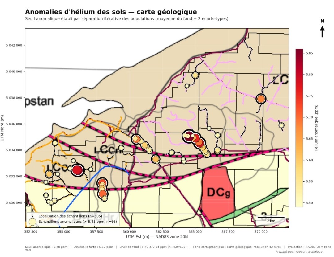
Figure 1. Helium anomalies on the Nova Scotia geological map. The anomalies occur principally within Carboniferous sedimentary units of the Cumberland Group, with additional anomalies in Horton Group units south of the North Cobequid fault. The Devono-Carboniferous granite (DCg) lies 1.5-2 km south-east of Zone C. Interpretation: Prof. M. Richer-Laflèche, INRS.
To view an enhanced version of this graphic, please visit:
https://images.newsfilecorp.com/files/7968/316275_48e6c99634546977_001full.jpg
Spatial relationship between helium anomalies and faults
Analysis of the spatial relationship between the position of the helium anomalies and that of the faults nearest to the sampling sites reveals a close geometric association between the principal structural breaks and the helium concentrations measured in soils. Overall, the anomalies tend to concentrate in a restricted zone, within 1.5 km on either side of faults F-I, F-II and F-III. It should be noted that the spatial distribution of helium anomalies around a fault can serve as a qualitative indicator of the permeability of the host rock. In a low-permeability setting (for example, granitic basement), transport should be limited to diffusion along the fracture planes of the fault, producing a relatively narrow corridor of anomalies and a rapid decay of the signal with distance. In a more permeable setting, such as the New Salem and Apple River sectors (porous Lower Carboniferous sandstones and conglomerates), gas can migrate laterally through the rock matrix once it has reached the near-surface, which widens the corridor and flattens the decay curve.
The data presented in Figure 2 are more compatible with the presence of relatively porous rocks. In the context of exploration for hydrogen, helium or natural gas, this observation suggests, a priori, the presence of porous and permeable rocks - one of the essential elements in the formation of a reservoir.
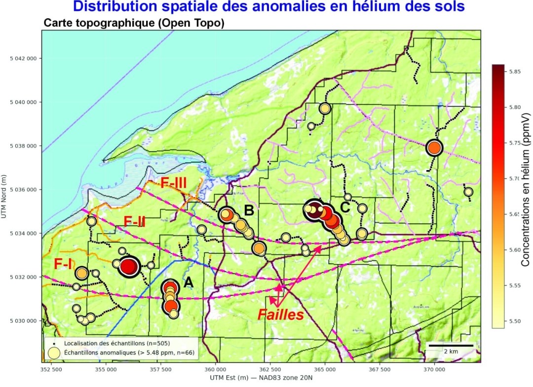
Figure 2. Spatial distribution of soil-gas helium anomalies relative to faults F-I, F-II and F-III, New Salem-Apple River sector, Cumberland Basin (anomalous stations > 5.48 ppmv). Anomalies concentrate within 1.5 km of the faults; the width of the corridors is consistent with porous, permeable Lower Carboniferous host rocks. Interpretation: Prof. M. Richer-Laflèche, INRS.
To view an enhanced version of this graphic, please visit:
https://images.newsfilecorp.com/files/7968/316275_48e6c99634546977_002full.jpg
Gravity: the basin-basement transition zone
The presence of the faults is a key element in the distribution of helium at the local scale. It does not, however, by itself explain the intensity or the regional character of the anomalies observed. To explain the distribution of the helium anomalies, we used the gravity and aeromagnetic data available for this sector of Nova Scotia. The use of gravity data, presented in Figure 3, is a classic step in the study of a sedimentary basin for energy-resource exploration (hydrocarbons, hydrogen, geothermal). The observed spatial variations of the Bouguer anomaly underline, in a simple and robust manner, a strong contrast between the north-west (low-density sedimentary rocks of the Cumberland Basin) and the south-east (high-density rocks of the Cobequid Highlands). A transition zone, dipping to the north-west, marks the contact between the Cumberland Basin and the older terranes to the south. In basin studies this type of transition is common and frequently controls the transfer of gases (focusing), because the older basement rocks (gravity high), rich in granitoids, are poorly permeable to fluids and gases compared with the sandstone and conglomerate rocks of the Lower Carboniferous, which are much more porous and permeable. The distribution of helium anomalies on the gravity map highlights a dual control, involving first the transition zone and second the faults F-I, F-II and F-III. The clustering of a large number of anomalies in anomalous Zones B and C justified a more detailed study, based on processing of the local aeromagnetic data (Figure 4).
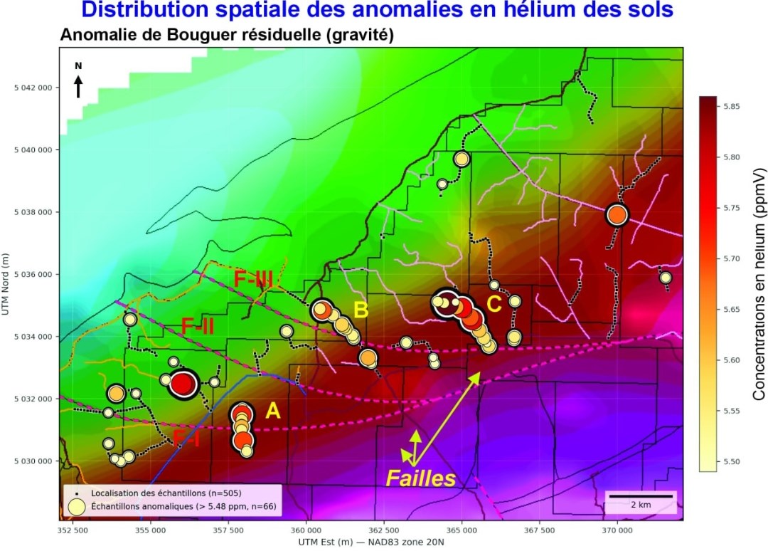
Figure 3. Helium anomalies on the residual Bouguer gravity field. Zones A, B and C lie strictly within the north-west-dipping transition zone (ramp) between the low-density Cumberland Basin to the north-west and the dense Cobequid Highlands basement to the south-east. Interpretation: Prof. M. Richer-Laflèche, INRS.
To view an enhanced version of this graphic, please visit:
https://images.newsfilecorp.com/files/7968/316275_48e6c99634546977_003full.jpg
Aeromagnetics: a magnetic intrusive body beneath Zones B and C
Tilt-derivative processing of the aeromagnetic data sharpens the edges of magnetic sources at depth. It reveals a discrete magnetic body approximately 10 km long and 2 km wide beneath anomalous Zones B and C, along fault F-III. Fault F-III follows the south-western edge of this body, and both zones occur where the fault bends or intersects cross-structures. This magnetic intrusive body is interpreted as the likely deep source of the degassing observed at surface. Tilt-depth analysis of the same data places the top of the magnetic basement at roughly 600-750 m beneath Zone C and 900-1 000 m beneath Zone B (Figure 5).
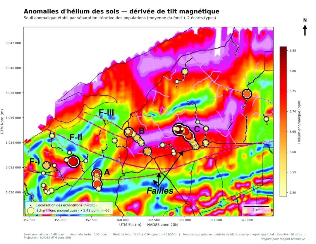
Figure 4. Helium anomalies (circles, sized and coloured by concentration) on the tilt derivative of the total magnetic field. Zones B and C sit on the same tilt-derivative ridge - the edge of a buried magnetic intrusive body approximately 10 km × 2 km - which fault F-III follows. Processing and interpretation: Prof. M. Richer-Laflèche, INRS (Oasis montaj; NAD83 UTM 20N).
To view an enhanced version of this graphic, please visit:
https://images.newsfilecorp.com/files/7968/316275_48e6c99634546977_004full.jpg
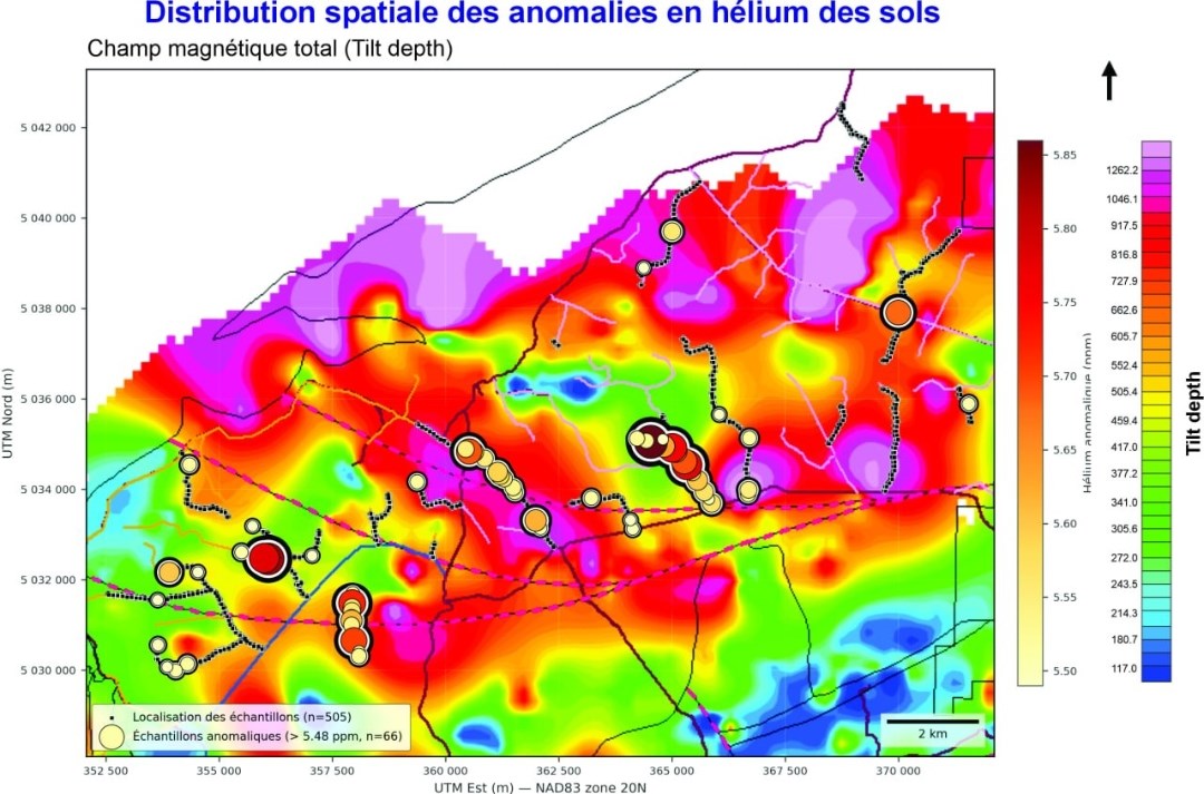
Figure 5. Tilt-depth estimate of depth to the top of the magnetic basement. Zone B overlies roughly 900-1 000 m of cover; Zone C roughly 600-750 m. Estimates are indicative (±20-30%) pending seismic and drilling calibration.
To view an enhanced version of this graphic, please visit:
https://images.newsfilecorp.com/files/7968/316275_48e6c99634546977_005full.jpg
The Geological Model
Crystalline basement is effectively impermeable, so gas generated within or beneath it migrates along the basement-sediment interface toward the shallow edge of the basin and escapes where regional faults breach the cover. At New Salem-Apple River the gravity data image that rising interface as a ramp, the aeromagnetic data show a discrete basement block whose edge fault F-III follows, and the helium reaches the surface precisely where the faults bend or intersect along that edge. The Lower Carboniferous units cut by these faults host most of the anomalies. This basement-ramp-and-fault configuration is similar to the one that focuses helium migration in producing helium provinces internationally.
No Hydraulic Fracturing, No Reservoir Stimulation
The gases identified at New Salem-Apple River - helium and, elsewhere on the corridor, clean natural hydrogen and thermogenic hydrocarbons - are migrating naturally through faults and along the basement interface to the surface today. The exploration model is therefore conventional: gas trapped in porous sandstones within fault-bounded structures at 600-1 000 m, to be tested by conventional wells and produced, if warranted, by natural flow. QIMC does not use hydraulic fracturing or any other form of reservoir stimulation and has no intention of doing so in Nova Scotia. This is a natural-flow, low-footprint exploration model, consistent with the Company's approach to clean natural hydrogen at Apple River-Bennett Hill.
Qualified Person
The scientific and technical information in this news release has been reviewed and approved by Professor Marc Richer-Laflèche, Ph.D., P.Geo., of the Institut national de la recherche scientifique (INRS), a Qualified Person as defined by National Instrument 43-101. Professor Richer-Laflèche led the geological and geophysical interpretation described in this release.
ABOUT QUÉBEC INNOVATIVE MATERIALS CORP.
Québec Innovative Materials Corp. is a North American exploration and development company advancing a portfolio of natural hydrogen and critical mineral projects. The Company is advancing its district-scale hydrogen exploration model across Québec, Ontario, Nova Scotia and Minnesota, leveraging its proprietary R2G2™ framework.
QIMC is committed to responsible exploration, technical innovation and sustainable development, with the objective of supporting clean energy and decarbonization initiatives.
FOR FURTHER INFORMATION
QUÉBEC INNOVATIVE MATERIALS CORP.
John Karagiannidis
President & Chief Executive Officer
Email: info@qimaterials.com
Tel: +1 514-726-7058
Website: www.qimaterials.com
The Canadian Securities Exchange has not reviewed and does not accept responsibility for the adequacy or accuracy of the content of this news release.
CAUTIONARY NOTE REGARDING FORWARD-LOOKING STATEMENTS
This news release contains forward-looking statements and forward-looking information within the meaning of applicable Canadian securities laws. Such statements include, without limitation, the planned scope, timing and objectives of the Company's expanded Nova Scotia seismic program; additional soil-gas sampling and interpretation of C1-C4 hydrocarbon results; the anticipated contribution of integrated geological, geochemical and geophysical studies to exploration targeting; potential future drilling and subsurface testing; and the Company's strategy to evaluate potential conventional gas accumulations without hydraulic fracturing or reservoir stimulation. Forward-looking statements are generally identified by words such as "plans," "expects," "intends," "anticipates," "potential," "may," "will" and similar expressions, although not all forward-looking statements contain these words.
Forward-looking statements are based on management's current expectations and assumptions, including the availability of sufficient financial resources, qualified personnel, contractors and suitable equipment; obtaining or maintaining necessary permits, authorizations and land access; suitable weather and operating conditions; and the ability to acquire and interpret data of sufficient quality to advance the exploration objectives described in this release. These statements are subject to risks and uncertainties that could cause actual activities, results or outcomes to differ materially, including operational delays, changes in program scope or costs, permitting or access constraints, equipment availability, limitations in data quality or geophysical resolution, and the possibility that further exploration will not support the current geological model or identify a commercially viable gas accumulation.
There can be no assurance that the planned programs will be completed as anticipated, that interpreted targets will be confirmed, or that exploration will lead to development or production. Readers are cautioned not to place undue reliance on forward-looking statements. Such statements speak as of the date of this news release, and the Company undertakes no obligation to update them except as required by applicable securities laws.
Caution Regarding Exploration Results and Interpretations
The soil-gas anomalies and integrated geological and geophysical interpretations described in this release are exploration indicators used to guide further investigation. They do not, on their own, establish the presence of a subsurface gas reservoir or an economically recoverable accumulation of helium, hydrogen or hydrocarbons. Spatial relationships between helium anomalies, mapped faults and interpreted basement features support a working geological model but do not independently confirm the source of the gases, their subsurface migration pathways, or the presence and continuity of gas-bearing traps. Inferences regarding rock porosity and permeability drawn from the distribution of soil-gas anomalies are qualitative and have not been confirmed by drilling or core measurements in the target areas discussed.
Interpretations of the geometry, extent and depth of magnetic sources are subject to modelling assumptions and significant uncertainty. Depth estimates derived from magnetic data refer to an interpreted magnetic source or basement feature and should not be interpreted as confirmed depths to gas-bearing formations or reservoirs. Further seismic investigation and, where warranted, drilling and appropriate subsurface testing are required to evaluate these interpretations and potential reservoir conditions.
References to a conventional, non-stimulated exploration model describe the Company's intended approach and do not establish that any accumulation could sustain commercially meaningful natural flow. Soil-gas concentrations and geophysical interpretations are not measurements of reservoir gas composition, formation pressure, gas flow rate, reservoir deliverability or recoverable volumes. Results from the Company's drilling at Bennett Hill, and comparisons with producing helium provinces elsewhere, provide exploration context but are not necessarily indicative of geological conditions, gas concentrations or potential productivity at New Salem-Apple River.

To view the source version of this press release, please visit https://www.newsfilecorp.com/release/316275