Key Highlights
- Fully funded with a strong treasury to execute a discovery-focused 2026 exploration program
- Three strategic initiatives:
- Cape Ray resource growth;
- New major discoveries;
- Continual generation of drill-ready targets across the district-scale land package.
- Three priority focus areas:
- Cape Ray West & Isle aux Morts Granite - high-priority discovery target and initial drill focus[1];
- Bunker Hill - rapidly advancing new drill targets ahead of drilling later in 2026[2];
- Cape Ray Resource Corridor - relogging of historical drill core to identify new drilling targets.
- Largest diamond drill program since 2021 planned with flexibility to scale based on success:
- Up to 5,000 metres at Cape Ray West / Isle aux Morts Granite;
- Up to 5,000 metres at Bunker Hill;
- Cape Ray Resource Corridor drilling program to be scoped over the coming months once the relogging program is completed;
- Antimony story continues to evolve at Hermitage: High-resolution till sampling (891 samples) returned values up to 200 ppm antimony, significantly exceeding regional benchmarks (~40.9 ppm at Beaver Brook) and defining a coherent anomaly extending at least 620 metres and open along strike. [3]
Edmonton, Alberta--(Newsfile Corp. - April 28, 2026) - AuMEGA Metals Ltd (ASX: AAM) (TSXV: AUM) (OTCQB: AUMMF) ("AuMEGA" or "the Company") is pleased to outline its fully funded exploration program for 2026 and provide an update on results from its 2025 field activities.
The 2026 program represents the Company's largest and most focused exploration campaign to date and is designed to advance three key priorities across its district-scale land package along the Cape Ray Shear Zone ("CRSZ"):
Cape Ray West & Isle aux Morts Granite: a newly emerging, high-priority discovery opportunity that will be the initial focus of drilling[4];
Bunker Hill: advancing multiple new drill targets ahead of drilling later in the 2026 field season[5];
Cape Ray Resource Corridor: ranking and prioritising diamond drilling based on relogging of historical drill core, and reinterpretation of mineralisation controls, aimed at identifying new drill targets surrounding the Company's Mineral Resources[6].
The Company has a strong balance sheet following its recent $30 million[7] financing and plans a scalable drilling program of approximately 10,000 metres, with flexibility to increase or reduce drilling based on results.
Initial drilling is expected to include up to 5,000 metres at Cape Ray West / Isle aux Morts Granite and up to 5,000 metres at Bunker Hill, with additional drilling to be allocated based on results. A drilling program targeting extensions to known mineralisation within the Cape Ray resource corridor is being planned and will be scoped over the coming months.
AuMEGA Metal's Managing Director and CEO, Sam Pazuki commented:
"We are entering 2026 with a clear focus on discovery and resource growth across our district-scale land package.
Our program is centred on three priority areas. Within the resource corridor, we are advancing work to support a potential resource update, with resource extension drilling to be scoped over the coming months as we continue to refine our geological understanding. At Cape Ray West, including the Isle aux Morts Granite, we believe we have identified a highly compelling new discovery opportunity, and this will be the first area we drill. At Bunker Hill, we are rapidly advancing a growing pipeline of new drill targets ahead of drilling later in the year.
Importantly we have a strong treasury having recently closed on a $30 million financing allowing us to execute one of the most expansive exploration programs on the Cape Ray Shear Zone to date. Our planned drill program is intentionally flexible — we will allocate capital to success and scale drilling where we see results that confirm our models.
At Hermitage, the results from our geochemical survey have furthered the antimony opportunity with antimony-in-till values exceeding known benchmark values at the only operating antimony mine (Beaver Brook) in Newfoundland. This demonstrates the polymetallic and diversity of our business.
With over 110 kilometres of strike along a major gold structure that continues to deliver new discoveries nearby, our focus is on systematically building and testing high-quality targets with the goal of making a meaningful new discovery."
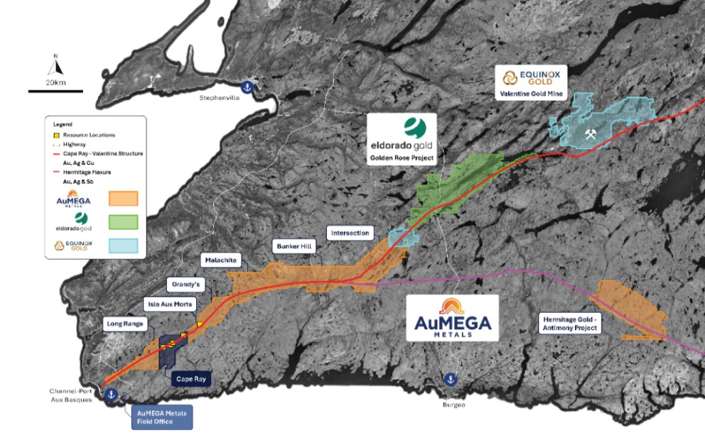
Figure 1. AuMEGA Metals portfolio on the Cape Ray Shear Zone and Hermitage Flexure.
To view an enhanced version of this graphic, please visit:
https://images.newsfilecorp.com/files/10713/294718_58687fbe2482d813_002full.jpg
2026 Exploration Program
The 2026 exploration program is designed to systematically advance high-priority targets across the CRSZ through a combination of drilling, geological refinement and ongoing target generation (Figure 2).
Drilling will be the central focus of the program, with an initial plan for approximately 10,000 metres across the Company's highest-priority targets. The program is intentionally scalable, with capital allocation driven by results.
Initial drilling allocations are expected to include:
- Up to 5,000 metres at Cape Ray West / Isle aux Morts Granite, where drilling will commence;
- Up to 5,000 metres at Bunker Hill, following target refinement.
A drilling program targeting extensions to known mineralisation within the Cape Ray resource corridor is expected to be scoped in the coming months as ongoing relogging and geological work is completed.
Supporting work programs, including geological mapping, relogging and targeted sampling, are underway to refine drill targeting and strengthen the Company's geological understanding across key areas.
In parallel, the Company will continue to build its pipeline of targets across the broader land package, including Cape Ray North, Intersection and Hermitage, ensuring a continuous pipeline of opportunities for future drilling.
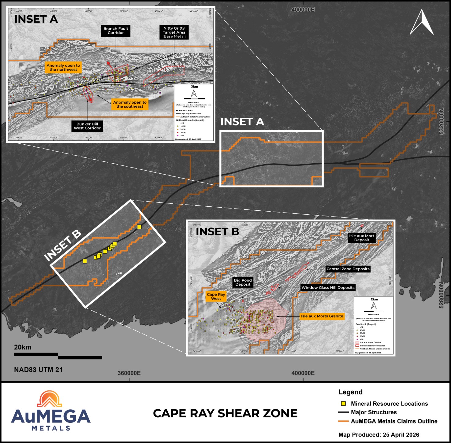
Figure 2. Surficial geochemistry overview for 2026.
To view an enhanced version of this graphic, please visit:
https://images.newsfilecorp.com/files/10713/294718_58687fbe2482d813_003full.jpg
Cape Ray West & Isle aux Morts Granite
Cape Ray West, including the Isle aux Morts Granite ("IMG"), has emerged as one of the most compelling exploration opportunities within the Company's portfolio (Figures 3 and 4).
Recent work has identified multiple high-priority target areas associated with favourable structural settings and geophysical features, supporting the potential for a large-scale mineralised system[8] (Figures 3 and 4).
The Company is now advancing toward a focused 2026 exploration program, with work to include:
- Extension of till sampling and geological mapping across the full extent of the IMG;
- Detailed 1:5,000-scale mapping and channel sampling over priority target areas;
- Execution of an initial targeted diamond drilling program with up to 5,000 metres.
This approach reflects an objective of maximising drill success and advancing the most prospective areas within the Cape Ray West corridor.
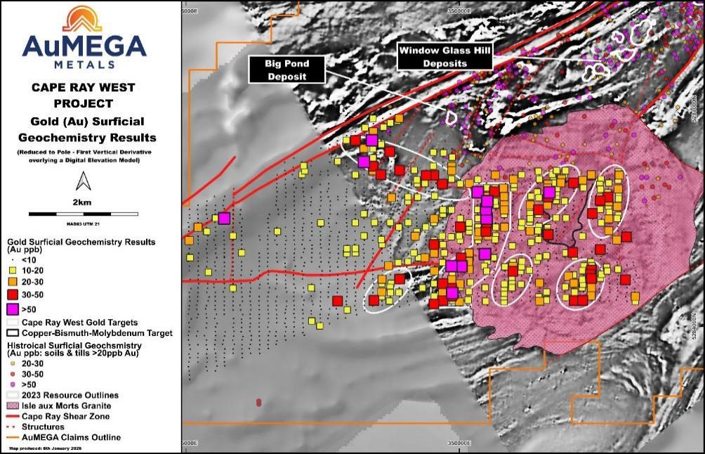
Figure 3. Target areas for detailed geological mapping, channel sampling and infill till geochemistry to expedite drill targets for 2026. The image is of the reduced to pole - first vertical derivative (greyscale) over a digital elevation model.
To view an enhanced version of this graphic, please visit:
https://images.newsfilecorp.com/files/10713/294718_58687fbe2482d813_004full.jpg
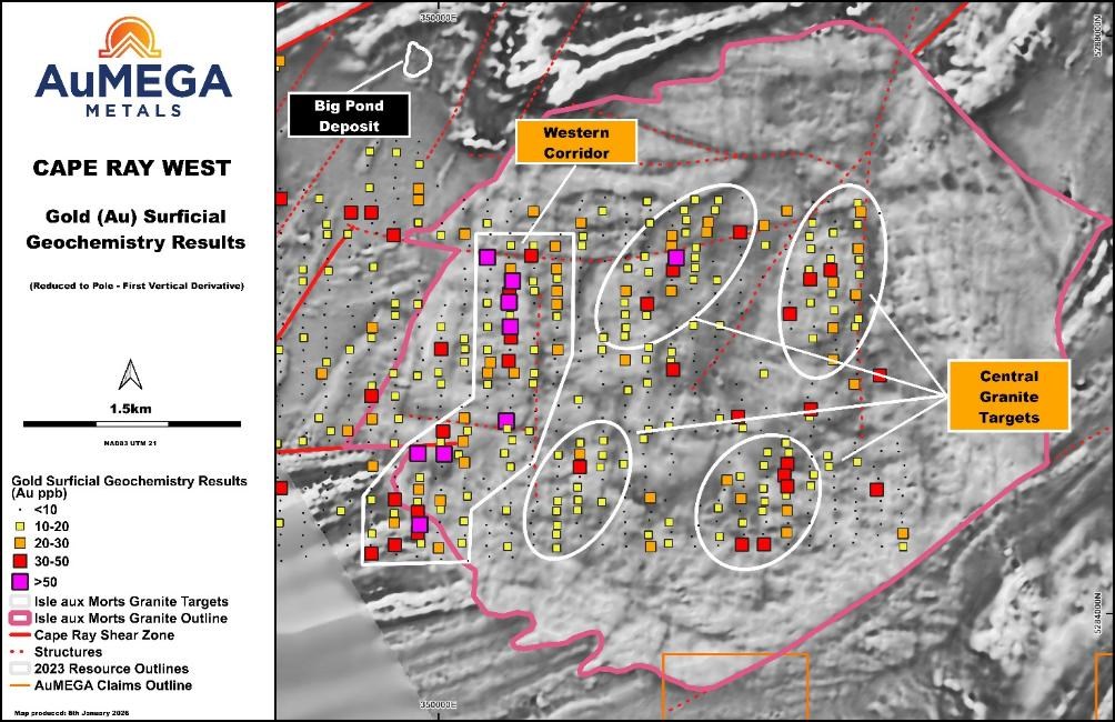
Figure 4. Target areas within the Isle aux Morts Granite. The image is of the reduced to pole - first vertical derivative (greyscale) over a digital elevation model.
To view an enhanced version of this graphic, please visit:
https://images.newsfilecorp.com/files/10713/294718_58687fbe2482d813_005full.jpg
Bunker Hill
At Bunker Hill, the Company has defined a growing number of high-quality drill targets, including a multi-kilometre gold trend associated with the Branch Fault Corridor[9] (Figure 5).
On a go-forward basis, the Company plans to:
Extend till sampling and mapping north of the Branch Fault Corridor to evaluate continuity;
Conduct additional regional-scale surveys to the east toward the Intersection Project to assess district-scale connectivity;
Complete detailed 1:5,000-scale geological mapping and channel sampling over the highest-priority anomalies; and
Advance a focused diamond drilling program of up to 5,000 metres, prioritising a smaller number of high-conviction targets rather than broad early-stage coverage.
The scale of the system and limited historical drilling highlight the potential for new discoveries.
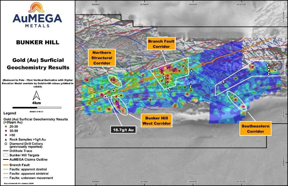
Figure 5. Anomalous areas from the 2025 till geochemistry programs requiring expedited follow-up work in 2026. The image is of the reduced to pole - first vertical derivative (greyscale) over a digital elevation model.
To view an enhanced version of this graphic, please visit:
https://images.newsfilecorp.com/files/10713/294718_58687fbe2482d813_006full.jpg
Cape Ray Resource Corridor
Within the Cape Ray resource corridor, the Company is undertaking relogging and work refining the geological model to support identifying new drill targets focused on extensions to known mineralisation[10] (Figure 6). The drilling program is expected to be scoped over the coming months, subject to further technical review and program design.
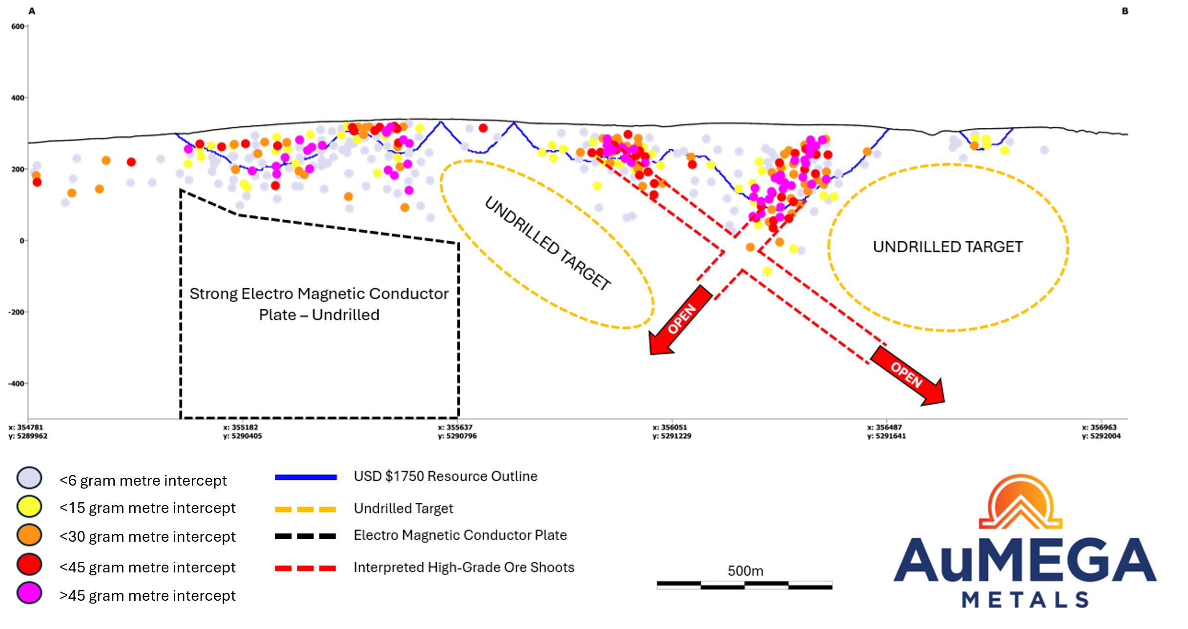
Figure 6. Long section of the Central Zone deposits (Z04, Z41, Z51 and H-Zone) looking towards the northwest (azimuth 320o)
To view an enhanced version of this graphic, please visit:
https://images.newsfilecorp.com/files/10713/294718_58687fbe2482d813_007full.jpg
Pipeline Growth Opportunities
Building on the Company's success in 2025, additional regional, target-generative till geochemistry and geological mapping programs are planned to further advance and expand the Company's exploration pipeline[11]. These programs are designed to systematically evaluate underexplored areas and generate new targets across key project areas on a network of underexplored second- and third-order structures associated with the CRSZ. Generally, in Newfoundland, the second and third-order structures have had limited exploration work despite the largest deposit on the island (Valentine) has its deposits and new discoveries on multi-order structures.
2025 Hermitage Surficial Geochemistry Program Results
Recent surficial geochemical work at Hermitage has identified a coherent antimony anomaly that compares favourably with known benchmarks in the province. Publicly available Newfoundland Geological Survey data over the Beaver Brook Antimony Mine indicate peak till values of approximately 40.9 ppm Sb from a regional one-kilometre by one-kilometre sampling grid (Open file report: NFLD/3273). In contrast, AuMEGA's inaugural, higher-resolution survey at Hermitage (160 m by 80 m spacing; 891 samples) returned a peak value of 200 ppm Sb (Figure 7). While comparisons between surveys of differing scale should be treated with appropriate caution, the tenor and consistency of the Hermitage response point to a meaningful antimony system.
The anomaly is both strong and spatially coherent, extending over at least 620 metres and remaining open along strike due to current survey coverage. Additional antimony anomalism identified in the southeastern portion of the grid suggests further upside, although continuity is not yet fully defined given the truncated nature of the survey in that area. These results provide an encouraging indication of scale and warrant follow-up work to better define the extent of the anomaly.
Gold results further enhance the prospectivity of the Hermitage project. The priority grid, centred on previously identified outcropping mineralisation grading 7.31 g/t and 2.10 g/t Au[12], returned peak till values of 53.5 ppb Au, reinforcing a relationship between known bedrock mineralisation and surficial dispersion patterns (Figure 8). This supports the effectiveness of the Company's targeting approach and highlights the potential to vector toward additional mineralised zones.
In addition, the highest gold value of the till geochemical survey, 57.4 ppb Au, was identified along a regional line in the southeastern portion of the grid, spatially associated with a well-defined west-northwest-east-southeast trending geophysical feature interpreted as a lithological contact (Figure 8). Although this anomaly is currently characterized by lower coherence, its structural association and the incomplete nature of the grid suggest potential for strengthening along strike with further work. Collectively, the coincident antimony and gold anomalism highlights a broader polymetallic system at Hermitage and supports the project's potential to attract strategic interest, including partnership or joint venture opportunities to advance the asset.
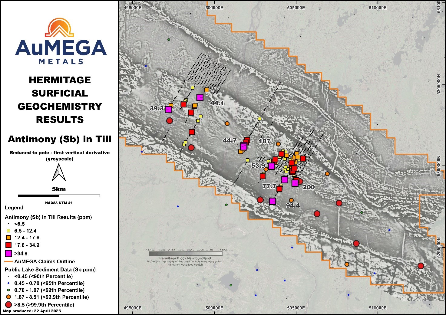
Figure 7. Antimony-in-till surficial geochemistry data from the 2025 survey. Strong and coherent anomalism is developing in the south-central portion of the project.
To view an enhanced version of this graphic, please visit:
https://images.newsfilecorp.com/files/10713/294718_58687fbe2482d813_008full.jpg
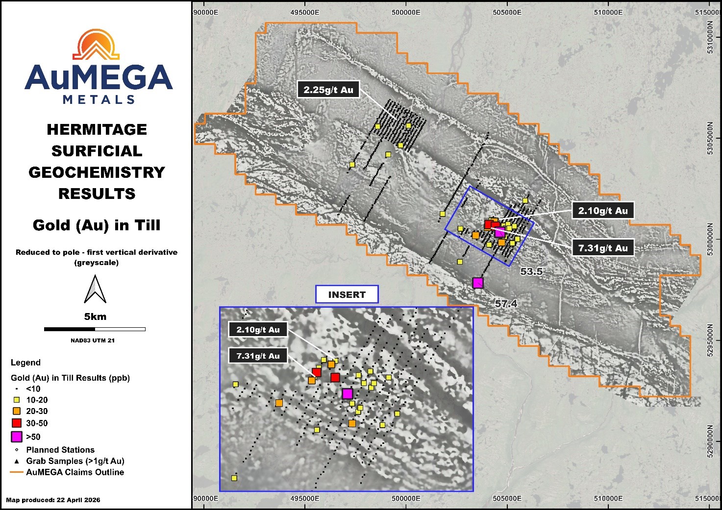
Figure 8. Results from the inaugural till geochemistry program at Hermitage. The image is of the reduced to pole - first vertical derivative (greyscale) over a digital elevation model.
To view an enhanced version of this graphic, please visit:
https://images.newsfilecorp.com/files/10713/294718_58687fbe2482d813_009full.jpg
2025 Electromagnetic Drilling Campaign
The electromagnetic ("EM") anomaly drilling program was designed to test a northeast-striking electromagnetic response interpreted to be hosted within the Port aux Basques Gneiss Complex, situated in the hanging wall to the Company's Central Zone deposits[13] (Figure 9).
A total of 1,476.17 metres over six diamond drill holes were completed as part of the EM anomaly drill program (Figure 9). There were no significant results to report from this drilling. The strong EM response appears to be associated with elevated concentrations of sulphide minerals, predominantly pyrite and pyrrhotite, within the host lithologies and derived from metamorphic processes rather than mineralised hydrothermal fluids.
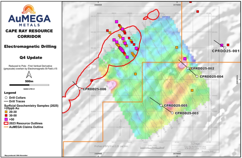
Figure 9. Overview of the 2025 electromagnetic drilling campaign. The image is of the reduced to pole - first vertical derivative (greyscale) over a digital elevation model with the Electromagnetic B-Field z15 data.
To view an enhanced version of this graphic, please visit:
https://images.newsfilecorp.com/files/10713/294718_58687fbe2482d813_010full.jpg
Update on the Blue Cove Project
Given the scale of the Company's portfolio and a strategic decision to focus on key project areas, challenging terrain and lack of material results from its 2024 exploration program[14], the Company has elected to exit its option agreement for Blue Clove and relinquish its mineral licenses for this project.
Summary of 2025 Exploration Program
Work completed in 2025 significantly advanced the Company's understanding of its land package and resulted in the identification of multiple new target areas across Cape Ray West, Isle aux Morts Granite and Bunker Hill.
In addition, targeted drilling programs, including electromagnetic anomaly testing, provided valuable geological information that has helped refine the Company's exploration model and improve targeting for 2026.
These results underpin the Company's prioritisation of drilling targets for the 2026 program.
< END >
This announcement has been authorised for release by the Company's Board of Directors.
To learn more about the Company, please visit www.aumegametals.com, or contact:
Sam Pazuki, Managing Director & CEO
Canada Phone: +1 780 665 4925
Australia Phone: +61 8 6117 0478
Email: info@aumegametals.com
About the Company
AuMEGA Metals Ltd (ASX: AAM) (TSXV: AUM) (OTCQB: AUMMF) is utilising best-in-class exploration to explore on its district scale land package that spans 110 kilometres along the Cape Ray-Valentine Shear Zone, a significant under-explored geological feature recognised as Newfoundland, Canada's largest identified gold structure. This zone currently hosts Equinox Gold's Valentine Gold Project, a multi-million-ounce deposit which is the region's largest gold project, along with AuMEGA's expanding Mineral Resource. Additionally, AuMEGA holds a 27-kilometre stretch of the highly prospective Hermitage Flexure.
The Company is supported by a diverse shareholder registry of prominent global institutional investors including Condire Investors LLC, and strategic investment from B2Gold Corp, a significant, intermediate gold producer.
AuMEGA's Cape Ray Shear Zone hosts several dozen high potential targets along with its existing defined gold Mineral Resource of 6.2 million tonnes grading an average of 2.25 g/t gold, totalling 450,000 ounces of Indicated Resources, and 3.4 million tonnes grading an average of 1.44 g/t gold, totalling 160,000 ounces in Inferred Resources.
AuMEGA acknowledges the financial support of the Junior Exploration Assistance Program, Department of Industry, Energy and Technology, Provincial Government of Newfoundland and Labrador, Canada.
Reference to Previous Announcements
In relation to this news release, all data used to assess targets have been previously disclosed by the Company and referenced in previous JORC Table 1 releases. Please see announcements dated: 13 September 2023, 18 May 2023, 10 April 2025, 16 October 2025, 8 January 2026, 15 January 2026 and 15 April 2026. In relation to the Mineral Resource estimate announced on 30 May 2023, the Company confirms that all material assumptions and technical parameters underpinning the estimates in that announcement continue to apply and have not materially changed. The Company confirms that the form and context in which the Competent Person's findings are presented have not been materially modified from the original market announcement.
Competent Person's Statements
Drilling and Analytical Procedures
Diamond drilling operations generally uses NQ sized core, with HQ sized core being utilised only in highly fractured ground to ensure maximum recovery and drill stability. All diamond drill core in competent ground is orientated using a REFLEX ACT III core orientation tool with the bottom-of-hole line marked. Downhole surveys for all NQ and HQ diamond drill holes are recorded using either a REFLEX EZ-TRAC survey or an OMNIx™42 gyro. The orientation of the holes is decided based on the Company's geological interpretation, down hole lengths are reported as true width is not known due to the Greenfields nature of drilling.
All diamond drill holes are logged in entirety by onsite geologists before being selected for sampling. For diamond drilling, samples typically range from 0.2 - 1.2 metres in length respecting the geological or mineralisation contacts present. The drill core is cut longitudinally following a pre-marked cutting line. A consistent hemisphere of the core is sent for analytical purposes whilst the other remains as a reference sample of the interval. Pre-numbered alpha-numeric sample bags holding the individual samples are sealed and placed into bulk-bags which is distributed to the laboratory for analysis.
AuMEGA metals used ALS Laboratories in Moncton, New Brunswick for the analysis of diamond drill core. All samples are dried to 60°C, crushed to 70% passing 2mm, riffle split to 250 grams and pulverized to 85% passing 75µm. Gold is analyzed by fire assay with an ICP-AES finish. Select samples are also analyzed by a 48 element 4-acid digestion with ICP-MS. Samples are securely stored at the Company's facilities until they are shipped either by a trusted 3rd party shipper or company personnel to the lab. ALS is an ISO accredited laboratory and is independent from the Company.
All sampling was carried out under AuMEGA's sampling guidelines which adheres to industry best practice. All QA/QC data is reviewed by the Database Manager, Exploration Manager and/or Competent Person to ensure quality of assays; batches containing multiple Certified Reference Material (CRM) that report outside of two standard deviations from expected values are re-assayed. Any batches containing individual CRM's greater than three standard deviations from expected values are also re-assayed.
The Company does not recognise any factors from the drilling, drill recovery, sample condition or sampling protocols that may affect the accuracy of the results or cause bias.
Till Sampling
All till samples are collected using a hand auger to collect roughly 2 kg of material, the 'C-Horizon' is targeted but the 'B-Horizon' is collected where this is not possible. Notes are taken on the sample horizon as well as the sand vs silt fractions and moisture content. Samples are then sealed in pre-marked calico bags. Till samples are organized at the Company's facilities in Channel Port-aux-Basques, NL., before they are driven by company personnel to Eastern Analytical's facilities in Springdale, NL., for drying at 60°C and sieving to -63 μm. The dried and sieved fraction is then shipped to ALS Global ("ALS") facilities in Vancouver, BC where they undergo ICP-MS for 53 elements after an aqua regia digestion. All QA/QC data is reviewed by the Database Manager, Exploration Manager and/or Competent Person to ensure quality of assays. Batches containing multiple CRMs that report outside of two standard deviations from expected values are re-assayed. Both Eastern Analytical and ALS are ISO certified and are independent from the company.
Historic Results
Some data disclosed in this news release is related to historical sampling. The company has not independently analyzed the results in order to verify the results; however, the Company considers these historical results relevant as the Company is using this data as a guide to plan exploration programs. The full results of the historical work referenced in this release can be accessed online.
Qualified Person
The scientific and technical information in this press release was reviewed and approved by Shamus Duff, P. Geo., Project Geologist. Mr. Duff is a Qualified Person as defined under National Instrument 43-101 and a Professional Geologist registered with Professional Engineers and Geoscientists of Newfoundland and Labrador (PEGNL). Mr. Duff consents to the publication of this press release and certifies that the information is provided fairly and accurately represents the scientific and technical information disclosed within it.
Appendix 1 - Drill Hole Collars and Intercepts
Table 1: Drill collar information.
| Hole ID | UTM_E | UTM_N | RL (m) | Dip (o) | Azimuth (o) | Hole Depth (m) | Status |
| CPRDD25-001 | 357605 | 5291399 | 354 | -45 | 305 | 236.12 | NSR |
| CPRDD25-002 | 357138 | 5291144 | 348 | -45 | 310 | 317.00 | NSR |
| CPRDD25-003 | 356938 | 5290579 | 348 | -45 | 310 | 263.00 | NSR |
| CRPDD25-004 | 357252 | 5291041 | 356 | -45 | 310 | 254.05 | NSR |
| CPRDD25-005 | 356814 | 5290690 | 338 | -45 | 310 | 250.00 | NSR |
| CPRDD25-006 | 355768 | 5290884 | 336 | -50 | 318 | 156.00 | See Table 2 |
NSR = No Significant Results. All coordinates are displayed in NAD83, UTM Zone 21.
Table 2: SIGNIFICANT DRILL HOLE INTERCEPTS TABLE: 0.2g/t Au & 0.5g/t Au cut-off*
| SIGNIFICANT DRILL HOLE INTERSECTIONS | ||||||
| Hole ID | 0.2 g/t Au cut-off | 0.5 g/t Au cut-off | ||||
| From (m) | Width (m) | Au (g/t) | From (m) | Width (m) | Au (g/t) | |
| CPRDD25-006 | 68.00 | 1.00 | 2.19 | 68.00 | 1.00 | 2.19 |
| 75.00 | 1.00 | 0.29 | - | - | - | |
| 116.40 | 1.60 | 1.17 | 117.00 | 1.00 | 1.64 | |
* All composites are reported with maximum 4 metres of internal waste material and reported with a 0.2g/t Au and 0.5g/t Au cut-off grade. Shorter, higher-grade intervals not included in the 0.2g/t and 0.5g/t Au cut-offs are included in the comments.
[1] News Release 15 January 2026 & 16 October 2025
[2] News Release 8 January 2026
[3] Based on publicly available data: Open file report - NFLD/3273
[4] News Release 15 January 2026 & 16 October 2025
[5] News Release 8 January 2026
[6] News Release 30 May 2023
[7] News Release 15 April 2026
[8] News Release 15 January 2026 & 16 October 2025
[9] News Release 8 January 2026
[10] News Release 30 May 2023
[11] News Release 15 January 2026, 8 January 2026 and 16 October 2025
[12] News Release 13 September 2023 & 18 May 2023
[13] News Release 30 May 2023
[14] News Release 10 April 2025
![]()
To view the source version of this press release, please visit https://www.newsfilecorp.com/release/294718
Source: AuMEGA Metals Ltd.