Vancouver, British Columbia--(Newsfile Corp. - February 10, 2026) - Homeland Uranium Corp. (TSXV: HLU) (OTCQB: HLUCF) (FSE: D3U) ("Homeland" or the "Company") reports the completion of its Phase II exploration drilling program at the 100%-owned Coyote Basin Uranium Project (the "Project") (see Figure 1).
The Company completed 33 drillholes totaling 5,423 metres (17,792 feet) of Reverse Circulation drilling, exceeding the originally planned 5,300 metres (17,388 feet). Phase II drilling was designed to further evaluate the near-surface mineralized trend that contains an inferred historical uranium and vanadium resource of 35.4 million pounds of U₃O₈ and 17.7 million pounds of V₂O₅ (private internal report, Western Mining Resources, Executive Summary, Coyote Basin Uranium District, Rio Blanco and Moffat Counties, Colorado, January 1980). Drilling intersected elevated and locally anomalous radioactivity in all completed Phase II drillholes.
Roger Lemaitre, President and CEO of Homeland Uranium, stated, "The completion of our Phase II drilling program represents an important step forward in advancing the Coyote Basin Project. Drilling has consistently confirmed the presence of near-surface elevated radioactivity across a broad area. The continuity observed in both the central and southern portions of the Project provides confidence in the scale of the system and supports the geological interpretation developed to date. With drilling now complete, we look forward to receiving the geochemical results to further refine our understanding of the Project and guide future exploration."
The Coyote Basin Project is located in northwestern Colorado, near the communities of Rangely and Meeker, within the northeastern portion of the Colorado Plateau (Figure 1). The Colorado Plateau is a regionally significant uranium province that spans Utah, Colorado, Arizona, and New Mexico and hosts numerous sandstone-hosted uranium deposits.
Central Project Area: Elevated Radioactivity
Three northeast-southwest-oriented drill sections were completed in the central portion of the Project, comprising ten drillholes (CB-RC-0046 to CB-RC-0055; see Figure 2). This drilling was designed to evaluate the area of the historical mineralization defined by Western Mining Resources ("WMR") and to follow up on a reported historical drill intercept containing 0.826% U₃O₈ in historical drillhole CB-101 (private internal report, Western Mining Resources, Executive Summary, Coyote Basin Uranium District, Rio Blanco and Moffat Counties, Colorado, January 1980).
Downhole probe results from this area indicate a broadly laterally continuous, but locally variable near-surface interval of elevated to locally anomalous radioactivity extending from surface to depths of approximately 50 metres (164 feet) to 150 metres (492 feet) and covering an area approximately 800 metres (2,624 feet) by 400 metres (1,312 feet). This radioactivity is associated with similar rock types encountered within the Southern Project Area drilling that includes shales, claystones, and fine-grained sandstones. Locally anomalous values were typically on the order of 300 counts per second ("cps") or less, with the higher values occurring over narrow intervals on the scale of tens of centimetres.
Southern Project Area: Lateral Continuity of Elevated Radioactivity
Drilling in the southern portion of the Project area comprises 23 drillholes (see Figure 3) and was designed to evaluate the extent of historical uranium mineralization reported by previous operator WMR. Results from the Phase II Drilling Program has defined a laterally continuous horizon of elevated radioactivity extending over an area of approximately 1,000 metres (3,280 feet) east-west by 600 metres (1,968 feet) north-south, which remains open for expansion to the south and east (see the Company's news releases dated December 15, 2025, December 22, 2025, January 8, 2026, and January 22, 2026 available on the Company's website at https://www.homeland-uranium.com/news-releases or under its profile on SEDARplus.ca).
Anomalous values encountered in the southern drill area typically range between approximately 400 and 600 cps, with one localized peak value of approximately 2,300 cps recorded over an interval of approximately 10 centimetres.
Geochemical samples collected from the completed drillholes have been shipped to SGS Laboratories in Lakefield, Ontario, for analysis. Homeland will report geochemical and assay results once they have been received, compiled, and reviewed by the Company.
Quality Assurance/Quality Control
All drillholes are radiometrically logged using a calibrated QL40 SGR Spectral Gamma Ray downhole probe, which collects continuous spectral gamma measurements along the length of the drillhole. Gamma values are collected and reported as Counts Per Second. The probe response is calibrated using coefficients derived from the probe's most recent factory calibration and through comparison of probe responses to geochemical assay data from previously sampled intervals.
Spectral gamma tools measure natural radioactivity, and in situations where the uranium decay series is in equilibrium, such gamma readings can be converted into equivalent concentrations of uranium, thorium, and potassium. However, if the uranium decay series is not in equilibrium, conversion of spectral gamma into equivalent concentrations of uranium may not be accurate, a phenomenon known as uranium disequilibrium. Uranium disequilibrium has been documented to occur at the nearby former producing Maybelle Uranium Mine, located approximately 29 km (18 miles) northeast of the Coyote Basin Project (see Global Uranium & Enrichment's news release dated July 29, 2025 which can be found at https://wcsecure.weblink.com.au/pdf/GUE/02972557.pdf),
As a first step in determining the accuracy of QL40 SGR Spectral Gamma Ray downhole probe and determining whether uranium disequilibrium may occur at Coyote Basin, Homeland's geological team used a portable hand-held XRF (SciAps X-555 REE Analyzer) to test drill cuttings for the presence of uranium. Enough discrepancies have occurred when comparing the results of the Spectral Gamma Ray downhole probe and the XRF that additional geochemical and assay sampling will be required before uranium grades can be accurately determined.
Homeland has collected samples from each 5 ft interval of the drill holes for geochemical analysis which will be sent to SGS Laboratories in Lakefield, Ontario. SGS Lab is certified ISO 17043: General requirements for proficiency testing. All SGS laboratories are required to participate in SGS's internal Proficiency Testing (PT) program: Laboratory Quality Systems International (LQSi) program, the largest PT program in the mining world. The SGS LQSi program currently involves over 100 laboratories on a regular basis, both SGS and non-SGS participants. SGS LQSi holds accreditation to the conformity assessment standard ISO 17043: General requirements for proficiency testing.
All depths and intervals reported are drilled depths and downhole lengths, unless otherwise stated. True thicknesses have not yet been determined.
About Homeland Uranium Corp.
Homeland Uranium is a mineral exploration company focused on becoming a premier US-focused and resource-bearing uranium explorer and developer. The Company is 100% owner of the Coyote Basin and Cross Bones uranium projects in northwestern Colorado.
The Coyote Basin Project is reported by Energy Metals Corporation in its quarterly Management Discussion and Analysis dated September 30, 2006 filed with the Securities and Exchange Commission ("SEC") to contain an estimated historical resource of 8,850,000 tons grading 0.20% U3O8 and 0.10% V2O5 totaling 35.4 million pounds of U3O8 and 17.7 million pounds of V205 (see Energy Metal's SEC disclosure at https://www.sec.gov/Archives/edgar/data/1361605/000106299306003601/exhibit99-2.htm). This resource was calculated by the previous project operator, Western Mining Resources, based on a 1978-79 program of surface sampling, coring, drill hole chip sampling and gamma logging of 24 widely spaced holes (private internal report, Western Mining, Executive Summary, Coyote Basin Uranium District, Rio Blanco and Moffat Counties, State of Colorado, January, 1980).
The Company is not treating the Coyote Basin historical resource estimate as current mineral resources and the reader is cautioned not to rely on either of these estimates. A Qualified Person (as defined under National Instrument 43-101 - Standards of Disclosure for Mineral Projects ("NI 43-101")) has not done sufficient work to classify the historical resources from the project as current mineral resources or mineral reserves nor can the Company or the Qualified Person comment on the quality or verify the data obtained from the assay sampling programs from the project that were used to determine these historical resource estimates, as such information was not included in the historical reports acquired by Homeland. The Company is not treating the historical resource estimate as current mineral resources or mineral reserves and the Company and the Qualified Person is unable to compare the historical resource estimate to the CIM's current resource classification system at this time. The Coyote Basin Project any future NI 43-101 mineral resource estimate will require considerable further evaluation which will include completion of the Phase I drilling program and may require addition drilling to follow-up Phase 1 results.
Qualified Person
Nancy Normore., P.Geo., the Company's Vice President, Exploration, is a Qualified Person as defined in NI 43-101, and has reviewed and approved the technical content of this news release.
For further information, please contact:
Roger Lemaitre
President & Chief Executive Officer
Homeland Uranium Corp.
Tel: 306-713-1401
Email: info@homeland-uranium.com
Investor Relations
Kin Communications Inc.
Tel: 604-684-6730
Email: HLU@kincommunications.com
Neither the TSX Venture Exchange nor its Regulation Services Provider (as that term is defined in the policies of the TSX Venture Exchange) accepts responsibility for the adequacy or accuracy of this news release.
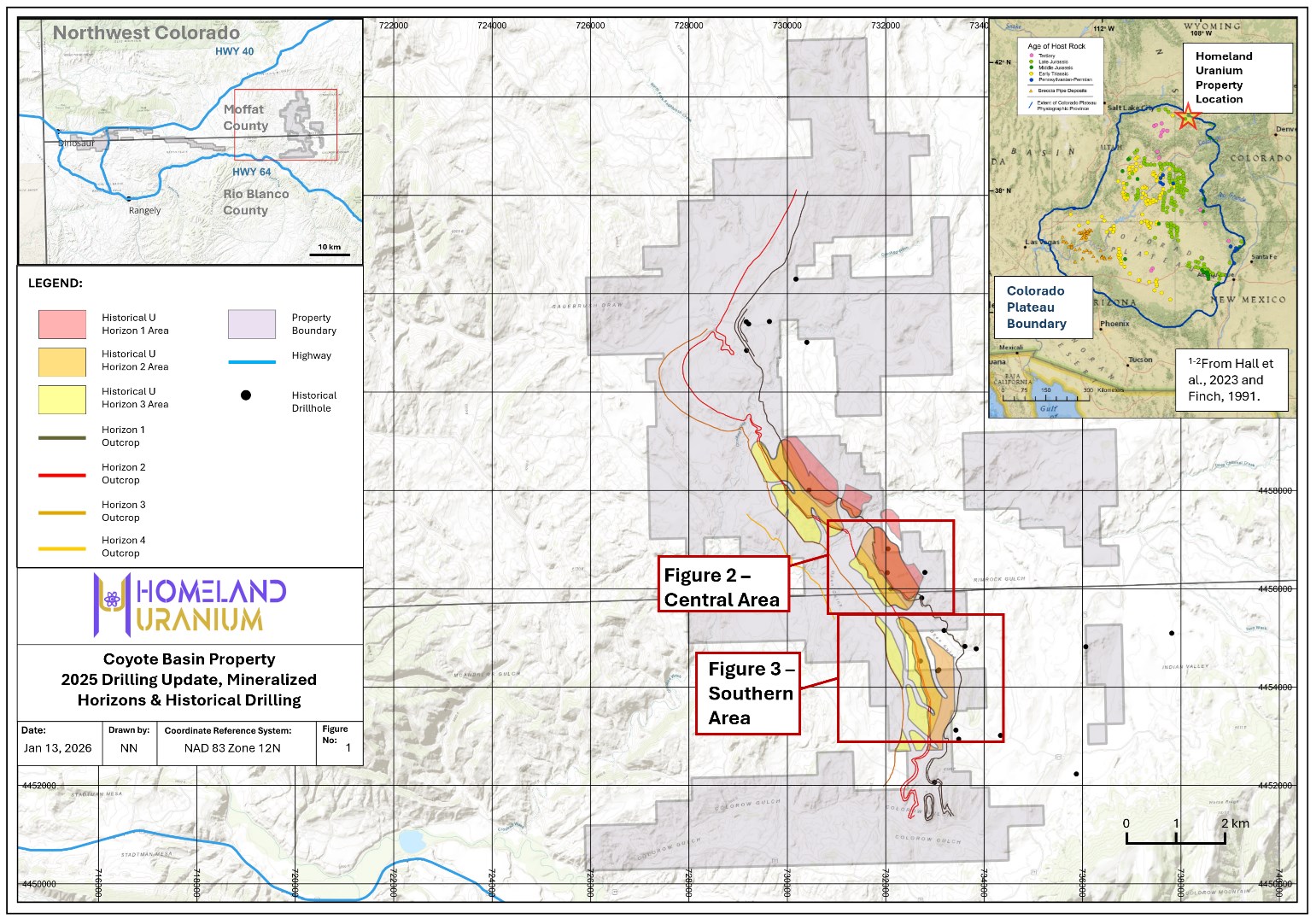
Figure 1 - Location of Homeland Uranium's Coyote Basin Project.
To view an enhanced version of this graphic, please visit:
https://images.newsfilecorp.com/files/10583/283383_44b57bec546aabd5_002full.jpg
Map references: 1: S.M. Hall, B.S. Van Gosen, R.A. Zielinski, 2023. Sandstone-hosted uranium deposits of the Colorado Plateau, USA. Ore Geology Reviews 155 (2023) 105353; 2: Finch, W. I., 1991, Maps showing the distribution of uranium-deposit clusters in the Colorado Plateau uranium province: U.S. Geological Survey Miscellaneous Field Studies Map MF-2080, 1 plate.
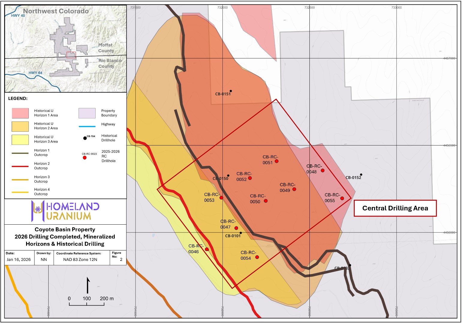
Figure 2 - 2026 Completed drillholes during Part 1 of Phase 2 - Coyote Basin Project - Central Area
To view an enhanced version of this graphic, please visit:
https://images.newsfilecorp.com/files/10583/283383_44b57bec546aabd5_003full.jpg
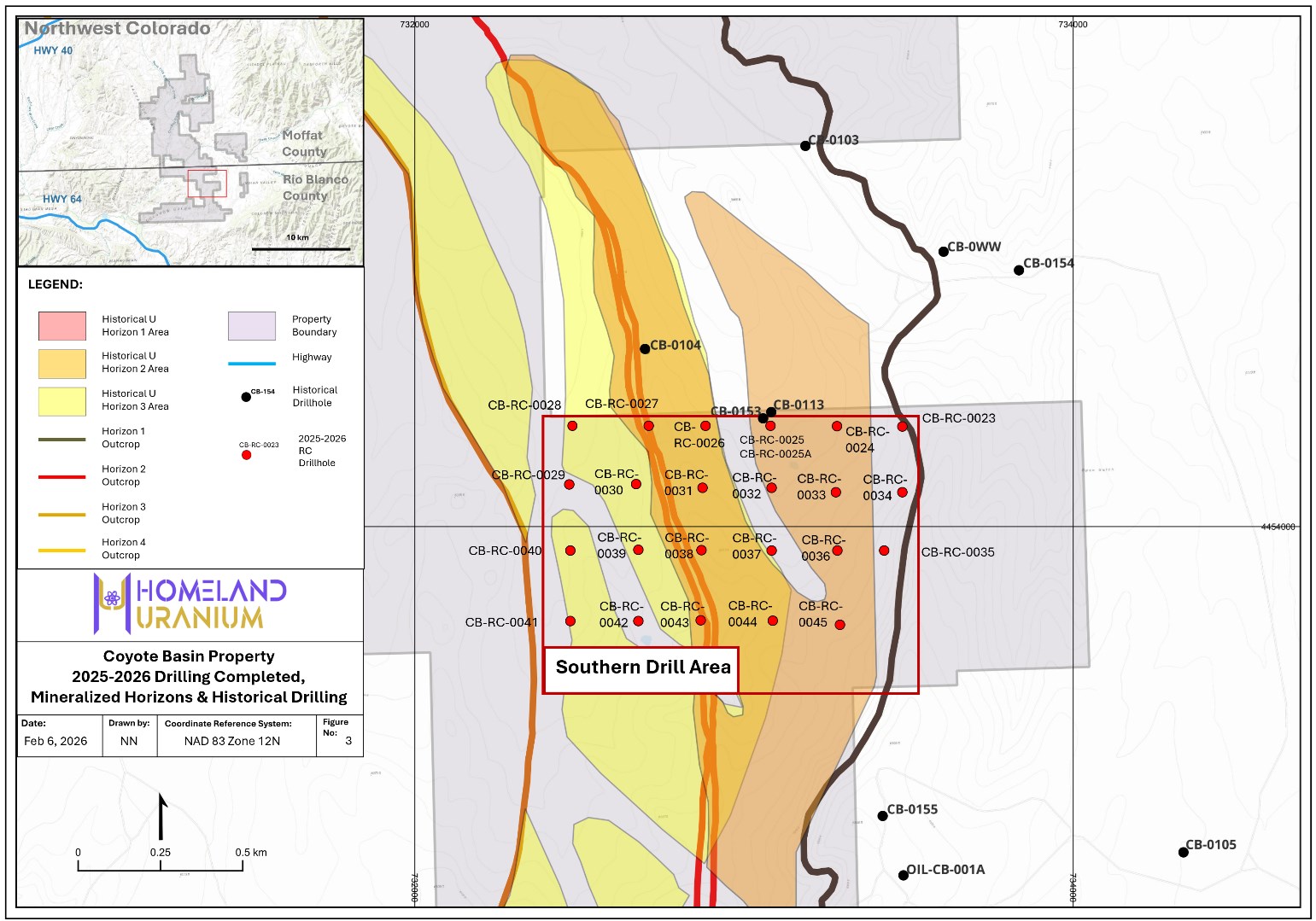
Figure 3 - 2025 Completed drillholes during Part 1 of Phase 2 - Coyote Basin Project - Southern Area
To view an enhanced version of this graphic, please visit:
https://images.newsfilecorp.com/files/10583/283383_44b57bec546aabd5_004full.jpg
![]()
To view the source version of this press release, please visit https://www.newsfilecorp.com/release/283383
Source: Homeland Uranium Corp.