Toronto, Ontario--(Newsfile Corp. - December 1, 2025) - Honey Badger Silver Inc. (TSXV: TUF) (OTCQB: HBEIF) ("Honey Badger" or the "Company") is pleased to share the results from the recent geophysical survey and prospecting work completed at it's 100%-owned Nanisivik Project, Nunavut. Nanisivik is a former polymetallic-silver mine that produced over 20 Moz of silver between 1976 and 2002(3), when low metal prices forced the mine into closure. Since then, silver and zinc prices are up approximately 1,000% and 300% respectively, and infrastructure access has improved with the construction of a deep-water port only a few kilometers from the former mine site.
The Company's Executive Chairman, Chad Williams, commented, "The recent surface exploration program completed at Nanisivik was a success: several large new zones with strong conductivity at the Area 14 and Oceanview targets were discovered. Some of these new zones may significantly extend the strike length of unmined mineralization at these targets while other new zones may represent completely new areas of mineralization. We are also very encouraged with assay results up to 249 g/t silver and 51.5% zinc collected from distal zones at the Area 14 target that coincide with underlying conductors from the Loupe EM survey. Nanisivik was a high-quality mining operation until 2002 when low commodity prices forced the mine to cease operations. We plan to drill these high-priority targets in 2026. We believe Nanisivik has substantial exploration potential."
2025 Data Review and Target Prioritization
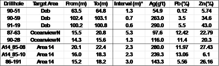
Earlier in the year, the Company announced three priority target areas that were identified during data review, each hosting significant zinc and silver intercepts from historical drilling (see press release dated March 25, 2025). The areas are Deb, Ocean View North, and Area 14. A review of historical exploration drilling at the former mine site identified several significant drill intersections located outside mined areas. These discoveries were not followed up in the past due to the previous operator's tight focus on production. As a result, each of these represents a priority target for follow up work. A selection of significant silver and/or zinc mineralized intercepts from these priority target areas is provided in the Table 2 and the locations of the target areas are illustrated in Figure 1.
2025 Exploration Program Summary
The recent exploration program at Nanisivik was primarily focused on utilizing ground geophysics (Loupe Time Domain Electromagnetics or "TDEM") as a cost-effective and portable method to:
- Outline subsurface conductors under known unmined mineralization at the Oceanview and Area 14 target areas, and
- Find new conductors in untested areas that may represent extensions of known massive sulfide mineralization.
Reconnaissance sampling was also completed around the Area 14 target to identify new zones of mineralization.
Results from the Loupe EM survey are very encouraging and have exceeded expectations for this program. The survey successfully identified conductors underlying unmined and partially mined mineralized areas at both Area 14 and across the broader Oceanview area. Importantly, the Loupe EM data shows several strong untested conductors at both Area 14 and Oceanview that are located between or adjacent to known zones of massive sulfide mineralization. These untested Loupe EM anomalies also coincide with historic airborne EM conductors, which further validates these areas as high-priority drill targets with potential for the discovery of new silver-lead-zinc massive sulfide mineralization (Figure 1).
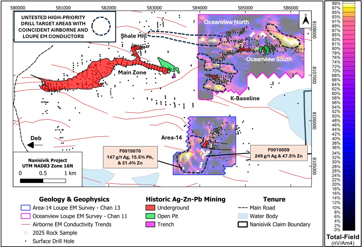
Figure 1. Map of the main Nanisivik block showing results from the recently completed Loupe EM surveys at the Oceanview and Area 14 targets as well as locations of rock samples collected during the work program. Strong untested conductors are highlighted in the dark blue dotted boxes. The locations of historical underground, open pit, or trenched silver-zinc-lead ore bodies are also shown on the map.
To view an enhanced version of this graphic, please visit:
https://images.newsfilecorp.com/files/3204/276371_3ba41a2c24f1f953_001full.jpg
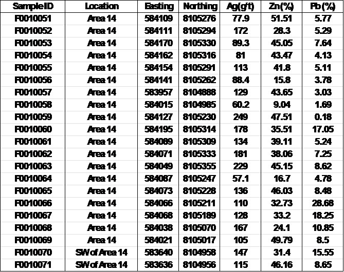
In addition to the success of the Loupe EM Survey, reconnaissance prospecting work has identified an area of potentially sub-cropping massive sulfide mineralization at Area 14 that has returned values up to 249 g/t silver and 51.5% zinc. In total, 21 grab samples were primarily collected from large angular boulders interpreted by the field geologist to potentially represent sub-crop from underlying or nearby bedrock. Due to partial snow cover at the time of sampling plus the historical disturbance related to reclamation after mine closure, it remains to be confirmed if each of these large angular boulders truly represent in-situ mineralization. These grab samples validate the high-grade nature of the mineralization seen in historic drilling at Area 14 and occur on top of a conductive body identified by the Loupe EM survey.
Table 1. 2025 Assay Results of Grab Samples from Area 14*
To view an enhanced version of this graphic, please visit:
https://images.newsfilecorp.com/files/3204/276371_3ba41a2c24f1f953_002full.jpg
Overview of Priority Target Areas
Oceanview North Target
There are no indications of any mining having been completed at the Oceanview North target area, which is located approximately 1.7 km east northeast from the main Nanisivik orebody and some 400 m north of the historically mined main Oceanview zone (Figure 1). At the Oceanview North area, data from some 72 historical exploration drillholes was examined and a cluster of high-grade Ag-Zn intersections were identified at the northern extent of the drilling. Highlight silver (Ag) and zinc (Zn) intersections at the Ocean View North target area include hole 87-63, which intersected 5.3m of 97.6 g/t Ag and 22.79% Zn, and hole 90-28 which intersected 1.3m of 116 g/t Ag and 20.3% Zn.
Area 14 Target
The Area 14 target is located approximately 1.8 km southeast of the main Nanisivik orebody (Figure 1). Historical data indicates that a portal was developed and some stope mining was carried out at Area 14. However, Honey Badger has examined the data from a cluster of 27 historical drillholes located immediately east and northeast of the historically mined area where a number of high-grade Ag-Zn intersections have been identified, including; hole A14_85-08 which intersected 2.3m of 280.0 g/t Ag and 27.43% Zn, hole A14_85-10 which intersected 2.3m of 239.3 g/t Ag and 6.10% Zn, and hole 86-191 which intersected 3.0m of 143.3 g/t Ag and 26.16% Zn.
Deb Target
The Deb target area is located approximately 3 km southwest of the main orebody at Nanisivik and is unmined. The Company has examined data from 15 drillholes completed in this area in the 1980's and 1990's. High-grade Ag-Zn intersections include; hole 90-51 which intersected 1.3m of 54.9 g/t Ag and 5.74% Zn, hole 90-59 which intersected 0.7m of 263 g/t Ag and 34.6% Zn, and hole 91-19 which intersected 0.6m of 290 g/t Ag and 43.0% Zn.
Table 2. Select Historical Drillholes from Unmined Areas at the Nanisivik Project*
To view an enhanced version of this graphic, please visit:
https://images.newsfilecorp.com/files/3204/276371_3ba41a2c24f1f953_003full.jpg
*reported as core length intervals as no information regarding true width is available (may include minor sample gaps where no grade has been assumed/assigned)
QAQC
Loupe TDEM Survey
The Loupe TDEM survey was completed by APEX Geoscience between August 27 to September 3, 2025. At the Oceanview target, a total of 16.7-line kilometers was completed over 14 lines. Lines were N-S oriented and spaced 250m apart with 125m infill spacing on the west side of the grid. At Area 14, a total of 11.4 line-kilometers was completed over 13 lines. Lines were E-W oriented and spaced 100m apart. The survey had a 10m Tx-Rx coil separation and used a 450 Hz base frequency.
Loupe TDEM is a man-portable, rapid, and inexpensive system developed by Loupe Geophysics (www.loupegeophysics.com.au) used to assess the conductivity of an area, particularly where there is significant outcrop and little to no weathering. The system is designed to measure electrical conductivity in the near-surface (generally between 20-50m depth) at high resolutions. The system provides x, y and z components of the EM field and is equipped with a real time RTK GPS system for accurate ground location.
Rock Samples
Sample preparation and multi-element analyses for rock samples were carried out at ALS Minerals' laboratories in Vancouver, British Columbia. Each rock sample was dried and fine crushed to better than 70% passing 2 mm, and then a 250 g split was pulverized to better than 85% passing 75 microns. The fine fraction was analyzed for 48 elements using four acid digestion (ME-MS61). For all samples, silver, lead and zinc were analyzed using an ore grade four acid digestion package with an inductively coupled plasma and atomic emission spectroscopy finish (Ag-OG63, Pb-OG62, Zn-OG62). Samples with zinc values over 30% and lead values over 20% were further analyzed using titration (Zn-VOL50 and Pb-VOL70). For all samples, an additional 30 g charge was further analyzed for gold by fire assay with inductively coupled plasma and atomic emission spectroscopy finish (Au-ICP21). At this early stage of mineral exploration, no Quality Control (QC) samples were inserted into the sample stream with the rock grab samples.
About Nanisivik
The Nanisivik Mine (near Arctic Bay, Nunavut) produced over 20 million ounces of silver between 1976 and 2002, from 17.9 million tons of ore, grading 9% zinc, 0.72% lead, and 35 grams per tonne of silver(3). In addition to the polymetallic orebody, previous exploration identified massive sulphide bodies (principally pyrite) still in place, totaling about 100 million tonnes(3) containing locally anomalous base metal and silver values.
Qualified Person
Technical information in this news release has been reviewed and approved by Benjamin Kuzmich, P. Geo., a consultant, who is a Qualified Person (QP) for the purpose of National Instrument 43-101 "Standards of Disclosure for Mineral Projects".
About Honey Badger Silver Inc.
Honey Badger Silver is a silver company. The company is led by a highly experienced leadership team with a track record of value-creation backed by a skilled technical team. Our projects are located in areas with a long history of mining, including the Sunrise Lake project with a historic resource of 12.8 Moz of silver at a grade of 262 g/t silver (and 201.3 million pounds of zinc at a grade of 6% zinc) Indicated and 13.9 Moz of silver at a grade of 169 g/t silver (and 247.8 million pounds of zinc at a grade of 4.4% zinc) Inferred(2) located in the Northwest Territories and the Plata high grade silver project located 165 km east of Yukon's prolific Keno Hill and adjacent to Snowline Gold's Rogue discovery. The Company's Clear Lake Project in the Yukon Territory has an unclassified historic resource of 5.5 Moz of silver at a grade of 22 g/t silver and 1.3 billion pounds of zinc at a grade of 7.6% zinc(3). The Company also has a significant land holding at the Nanisivik Mine Area located in Nunavut, Canada that produced over 20 Moz of silver between 1976 and 2002(4). In each instance, the reliability of the historical resource estimates (the "Historical Estimates") are considered reasonable, but a qualified person has not done sufficient work to classify the foregoing Historical Estimates as current mineral resources, and the Company is not treating the estimates as current mineral resources. There is no technical report associated with the Historical Estimates. The Historical Estimate contains categories that are not consistent with current CIM definitions. The Company considers the Historical Estimates to be relevant for the proper understanding of its mineral properties, however, significant data compilation, re-drilling, re-sampling and data verification may be required by a Qualified Person for the Historical Estimates to be in accordance with NI 43-101 standards and to verify the Historical Estimates as current mineral resources. No more recent estimates of the mineral resources or other data are available to the Company. There can be no certainty, following further evaluation and/or exploration work, that the historical estimates can be upgraded or verified as mineral resources or mineral reserves in accordance with NI 43-101.
(1) Sunrise Lake historic resource (2000-2003): Indicated 1.522 million tonnes grading 262 grams/tonne silver, 6.0% zinc, 2.4% lead, 0.08% copper, and 0.67 grams/tonne gold and Inferred 2.555 million tonnes grading 169 grams/tonne silver, 4.4% zinc, 1.9% lead, 0.07% copper, and 0.51 grams/tonne gold. The resource estimate for the Sunrise Deposit was carried out by Silver Standard Resources Inc. (SSR) using a classical polygonal method that relied on 72 diamond drillholes and an average density of 4 t/m3. Drill hole intercepts were taken directly from the drill logs (CBA 1998). Polygons were created within AutoCAD and AutoCAD calculated the areas. Horizontal widths were calculated using the ratio of core length to the width used by CBA in their 1998 estimate. Intercepts not used by CBA were measured on the cross sections. The intercepts were composited primarily using a geological cut-off based on the sulphide content and a nominal 30 g/t Ag grade. Internal values below 30 g/t were included for geological continuity if the composite remained above cut-off. Stringer mineralization was included where silver grades were above 30 g/t and occasionally lower if base metal grades were high. It is assumed the upper 100 m could be mined by open pit methods and the stringer mineralization would have to be removed to access the massive sulphides. The classification of the mineralization is based on the number of drill holes on a section and the continuity of the mineralization. The main massive sulphide horizon has been drilled on sections spaced 40 m apart, and above the -280 m elevation, the down dip continuity of the horizon has been tested with holes 25 to 30 m apart down dip. All mineralization in the massive sulphide horizon above 280 m is considered an Indicated Resource while the near surface stringer mineralization and the massive sulphides below 280 m are considered to be Inferred Resources. Forty holes define the massive sulphide Indicated Resource horizon. In a 2003 report to SSR, Roscoe Postle Associates Inc. (RPA) concluded SSR's resource estimate was reasonable based on approximating a NSR using typical smelter contracts, assuming metallurgical recoveries based on the limited metallurgical testing and on the following price assumptions: USD$ 5.50 per ounce silver, USD$ 400 per ounce gold, USD$ 0.45 per pound zinc, USD$ 0.25 per pound lead, and USD$ 0.80 per pound copper, as well as a USD$ 75 transportation cost, and a CDN$ 1.45:USD$ 1.00 exchange rate.
(2) Clear Lake historic Resource (2010): Inferred 7.76 million tonnes grading 22 grams/tonne silver, 7.6% zinc, and 1.08% lead. In 2010 SRK was engaged to complete a NI 43-101 compliant resource estimate for the Clear Lake deposit for Copper Ridge Explorations Inc. The estimate was made utilizing 1,842 assays from within the deposit, from a total of 13,168 m of drilling in 63 historical drill holes. An average density of 4.07 gm/cc was used, based on a limited number of field measurements that were confirmed in the laboratory, and with a minimum thickness of 2 m. Mineral resources were estimated by ordinary kriging in 12m by 12m by 9m blocks. The mineral resources are reported at a 4% (Pb+Zn) cut-off. Pb grades have been capped at 1.5% and Ag grades were capped at 60 g/t. Although SRK placed this resource in the inferred category due to uncertainties related to the historical nature of the available data, they noted that most of the resource has been drilled at a sufficiently close enough spacing to support indicated classification. The above information has been taken from a news release by Copper Ridge dated January 18th, 2010, as no technical report is publicly available.
(3) Geological Survey of Canada, 2002-C22, "Structural and Stratigraphic Controls on Zn-Pb-Ag Mineralization at the Nanisivik Mississippi Valley type Deposit, Northern Baffin Island, Nunavut; by Patterson and Powis."
ON BEHALF OF THE BOARD,
Chad Williams, Executive Chairman
Sonya Pekar
Investor Relations
spekar@honeybadgersilver.com | +1 (647) 498-8244
For more information, please visit our website www.honeybadgersilver.com.
Neither the TSX Venture Exchange nor its Regulation Services Provider (as that term is defined in the policies of the TSX Venture Exchange) accepts responsibility for the adequacy or accuracy of this release.
Cautionary Note Regarding Forward-Looking Information
This news release contains "forward-looking information" within the meaning of the applicable Canadian securities legislation that is based on expectations, estimates, projections and interpretations as at the date of this news release, including without limitation, the potential of the Nanisivik project. Any statement that involves discussions with respect to predictions, expectations, interpretations, beliefs, plans, projections, objectives, assumptions, future events or performance (often but not always using phrases such as "expects", or "does not expect", "is expected", "interpreted", "management's view", "anticipates" or "does not anticipate", "plans", "budget", "scheduled", "forecasts", "estimates", "believes" or "intends" or variations of such words and phrases or stating that certain actions, events or results "may" or "could", "would", "might" or "will" be taken to occur or be achieved) are not statements of historical fact and may be forward-looking information and are intended to identify forward-looking information. This forward-looking information is based on reasonable assumptions and estimates of management of the Company at the time such assumptions and estimates were made, and involves known and unknown risks, uncertainties and other factors which may cause the actual results, performance or achievements of Honey Badger to be materially different from any future results, performance or achievements expressed or implied by such forward-looking information.
Such factors include, but are not limited to, risks relating to capital and operating costs varying significantly from estimates; delays in obtaining or failures to obtain required governmental, environmental or other project approvals; uncertainties relating to the availability and costs of financing needed in the future; changes in equity markets; inflation; fluctuations in commodity prices; delays in the development of projects; other risks involved in the mineral exploration and development industry; and those risks set out in the Company's public documents filed on SEDAR+ (www.sedarplus.ca) under Honey Badger's issuer profile. Although the Company believes that the assumptions and factors used in preparing the forward-looking information in this news release are reasonable, undue reliance should not be placed on such information, which only applies as of the date of this news release, and no assurance can be given that such events will occur in the disclosed timeframes or at all. The Company disclaims any intention or obligation to update or revise any forward-looking information, whether as a result of new information, future events or otherwise, other than as required by law.
![]()
To view the source version of this press release, please visit https://www.newsfilecorp.com/release/276371
Source: Honey Badger Silver Inc.