Toronto, Ontario--(Newsfile Corp. - November 4, 2025) - ONGold Resources Ltd. (TSXV: ONAU) (OTCQB: ONGRF) (the "Company" or "ONGold") is extremely pleased to announce initial results from its recent diamond drilling program in the gold ridge area ("Gold Ridge") of the Ti-pi-ha-kaa-ning ("TPK") project located in Northern Ontario. The TPK project hosts two large independent mineralized systems and is comprised of 2,504 claims covering an area of 69,764 hectares within a highly favorable geological setting. The Gold Ridge area, the focus of this current exploration program, occurs at the head of a large gold grains-in-till dispersal corridor and is located in the northern portion of the expansive TPK property. The results of this program, plus previous exploration results are interpreted to indicate the presence of a large, intrusive-hosted, orogenic gold system. These geological interpretations are preliminary in nature; no mineral resource has been defined on the TPK project.
The diamond drilling program recently completed at Gold Ridge was designed to further define the extent of the Discovery Zone (as defined herein) as well as probe a strong Induced Polarization ("IP") anomaly coincident with anomalous gold and copper values in boulders identified at the western part of the Gold Ridge area. The recently completed program at Gold Ridge consisted of 2,169 m in 9 holes as well as a targeted surface geology mapping program.
This news release contains initial gold assay results for 8 holes of the 9 hole program. Remaining results and base metal values are pending and will be released once they have been received and verified by the Company. The first four holes targeted an historical intersection of 4.62 g/t gold over a core length of 5.5 m (from 145.6 m to 151.1 m), including 20.8 g/t gold over 1.0m (from 145.6 m to 146.6 m) in hole NG-12-003C (the "Discovery Zone"). All four holes drilled in the Discovery Zone were successful in intersecting this zone. Two of the holes were drilled near an historical IP anomaly up-ice of a gold grains in till anomaly and boulders containing highly anomalous gold and copper values in the west part of the Gold Ridge area. Two holes were drilled to test a series of NNE-trending shears and quartz veins near the terminus of historical anomalous gold grains in till values. The last hole (for which results have not been received) was drilled to test a diorite/volcanic contact and gold grains anomaly in the eastern part of the Gold Ridge area. To date, every hole with received assays in this area has returned anomalous gold values greater than 0.1g/t gold.
The highlights of the current program to date include:
GR-25-011: 19.39 g/t Au over a core length of 8.2 metres from 11.8 m to 20.0 m (including 308 g/t Au over 0.3m from 11.8m to 12.1 m and 24.80 g/t Au over 0.7 m from 12.1 m to 12.8 m, also including 12.20 g/t Au over 1.5 m from 17.0 to 18.5 m and 20.10 g/t Au over 1.5 m from 18.5 m to 20.0 m).
GR-25-012: 0.30 g/t Au over 56.4 metres from 206.0 m to 262.4 m (including 1.06 g/t Au over 7.85 metres from 206.0 m to 213.85 m, including 2.24 g/t Au over 1.6 metres from 208.0 m to 209.6 m and 2.08 g/t Au over 1.15 metres from 212.7 m to 213.85 m) in a new zone of mineralization, following up on a gold grains-in-till anomaly and anomalous gold and copper values in angular boulders.
GR-25-014: 5.2 g/t Au over 1.5 metres from 200.5 m to 202.0 m in a new zone near the terminus of a gold grains-in-till anomaly in the northern part of the Gold Ridge area.
Kyle Stanfield, CEO and a director of ONGold, commented: "The recently completed exploration program at TPK's Gold Ridge has succeeded in identifying a pervasive gold bearing system spread over a width of approximately 400 metres extending from the Discovery Zone to the shore of Mameigwess Lake, a length of 1,400 metres.1 Anomalous gold has been identified in each drill hole assayed to date including high gold grades associated with the Discovery Zone (19.39 g/t gold over a core length of 8.2 metres). The program represents a key turning point at TPK as it has verified that the Gold Ridge is at the head of a large gold grains-in-till dispersal corridor with multiple remaining targets identified. We are truly pleased to now reach the stage at TPK — Gold Ridge where further programs will continue to advance evaluation of the Gold Ridge system."
History
Property scale till sampling by earlier operators defined a 10 km long X 3.5 km wide gold grains-in-till dispersion train (the "Keeley Lake Train") of gold grains-in-till, which terminates in the Gold Ridge system area. Anomalous pristine gold grain counts define a NNE trending corridor in the north part of the project area. To the south, a second trend is defined by the abrupt termination of anomalous pristine gold grains in till and trends approximately 060 azimuth before swinging approximately east-west in the northeast part of the area (see Figure 1). Although the previous sampling was a coarse spacing (200 m to 500 m) the results suggest multiple sources of gold grains.
The till survey was followed up by a program of prospecting and boulder sampling. Of 100 historical samples of mineralized boulders, 24 returned anomalous gold values between 0.1 and 1.0 g/t gold and 9 assays > 1.0 g/t gold, including one that assayed 727 g/t gold, 111 g/t silver, 4.1% copper. Subsequent diamond core drilling in 2012 consisted of 2,241m in 7 holes and returned values of 4.62 g/t gold over a core length of 5.5 m (from 145.6 m to 151.1 m), including 20.8 g/t gold over 1.0m (from 145.6 m to 146.6 m) in hole NG-12-003C (now branded as the Discovery Zone) and 13.40 g/t gold over a core length of 1.90m (from 162.3 m to 164.2 m), including 41.5 g/t gold over 0.6m (from 162.3 m to 162.9 m) hole NG-12-005C, with every hole intersecting anomalous gold values over 100 ppb.2
Current Program
Nine diamond core holes were drilled for a total of 2,169 m of BQTK drilling size core. Oriented core was used to obtain structural measurements from the core and estimate the orientations of the features measured. The first four holes targeted the historical Discovery Zone intersection. Mineralization in this part of the Gold Ridge area is hosted in chloritic shears associated with sheared, chloritic mafic dykes cutting a diorite to quartz-diorite. The mapping program was instrumental in establishing that many of these shears are north-northeast trending and dip steeply to the west-northwest, a significant departure from earlier interpretations. The mapping supported the results of oriented core measurements from the drilling program, which saw many shears and veins striking 020 azimuth to 040 azimuth. Mineralization consists of quartz veins and stringers, accompanied by disseminated pyrite, pyrrhotite and local chalcopyrite. Reported intervals are length-weighted composites of uncut assays unless otherwise noted.
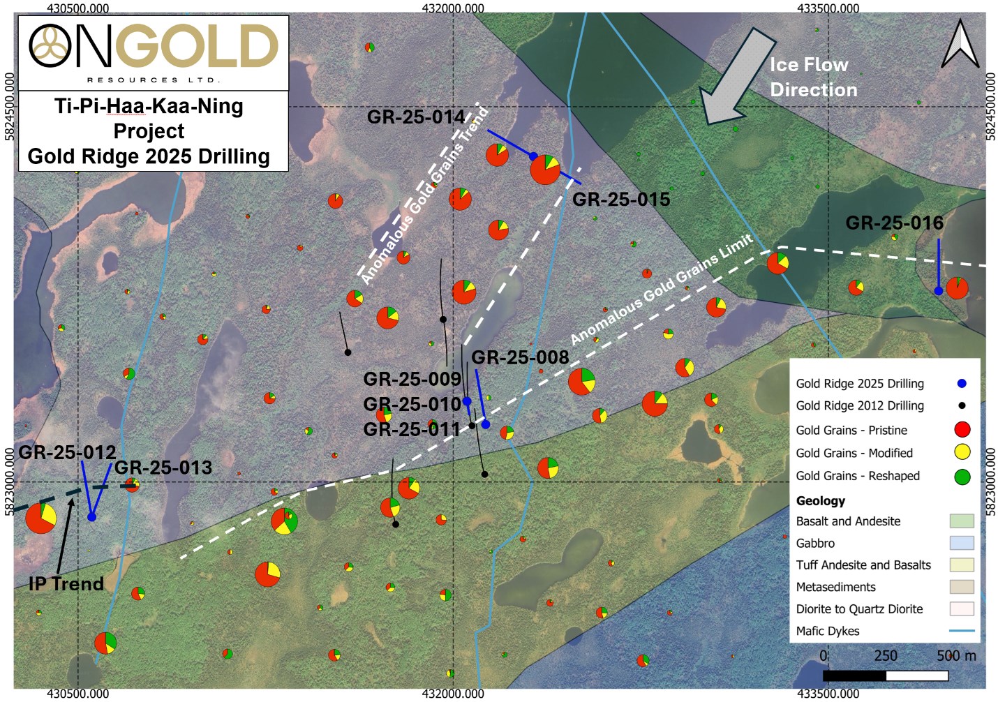
Figure 1 : Historical gold grains-in-till results, interpreted geology, historical and recent drilling, Gold Ridge area.
To view an enhanced version of this graphic, please visit:
https://images.newsfilecorp.com/files/10770/273050_3102b978a4e818ea_001full.jpg
Hole GR-25-008 targeted the Discovery Zone along strike to the east. The hole was successful in intersecting a chloritic shear and quartz vein from 211.7 m to 212.2 m that correlates with the Discovery Zone, a step out of approximately 65 metres. Several other shears and veins in the hole also gave anomalous gold values and slightly elevated gold values (10-30 ppb) were obtained through much of this hole.
Following the geological mapping and oriented core measurements from hole GR-25-008, the Discovery Zone was targeted up-dip of the historic intersection. Holes GR-25-009, 010 and 011 were drilled from the same site, all intersected the Discovery Zone and were successful in extending the Discovery Zone for 88 metres up-dip to a point just below the overburden/bedrock interface. In addition to the Discovery Zone, a second, new zone was also found in hole GR-25-010 from 11.3 m to 14.5m, grading 0.99 g/t gold over a core length of 3.2m (including 1.2 m grading 2.37 g/t gold from 13.3 m to 14.5 m).
Hole GR-25-011 intersected a strong quartz vein within sheared and chloritic diorite. Visible gold was seen parallel to the foliation in the sample from 11.8m to 12.1 m (See Figure 2). The overall zone from 11.8m to 20.0 m averaged 19.39 g/t gold over a length of 8.2 metres, including 308 g/t gold from 11.8 m to 12.1 m, 24.8 g/t gold over 0.7 m from 12.1 m to 12.8 m, 12.20 g/t gold from 17.0 m to 18.5 m and 20.1 g/t gold over 1.5 m from 18.5 to 20.0 m. Assays greater than 5 g/t gold were initially re-assayed fire assay with a gravimetric finish and subsequently analyzed by screened metallics assay.
Hole GR-25-012 was drilled near an historical IP anomaly up-ice of an historical till sample containing 157 pristine gold grains and historical grab samples of angular boulders which contained anomalous gold and copper values (see ONGold's news release dated September 4, 2025). The hole intersected a zone of quartz veining, local silicification, disseminated pyrite, pyrrhotite and chalcopyrite hosted in altered diorite and gabbro which assayed 0.30g/t gold over 56.4 metres from 206.0 m to 262.4 m (including 1.06 g/t gold over 7.85 metres from 206.0 m to 213.85 m in a zone consisting of 90% quartz, including 2.24 g/t gold over 1.6 metres from 208.0 m to 209.6 m and 2.08 g/t gold over 1.15 metres from 212.7 m to 213.85 m).
Further down the hole, GR-25-012 intersected a weak shear in gabbro which was biotized, weakly silicified and contains disseminated pyrite and chalcopyrite from 314.2 m to 319.15 m. A vein from 319.15 m to 319.55 m (0.4 m) contains a visually estimated 35% chalcopyrite. Note: visual estimates of a particular mineral do not necessarily assay values. Gold values from this zone averaged 1.50 g/t gold over a core length of 1.15 metres from 318.5 m to 320.0 m (including 4.45 g/t gold over 0.4 metre from 319.15 m to 319.55 m). Geochemistry and base metal assays are pending for this hole and results will be disclosed once available.
GR-25-013 attempted to intersect the veins found in hole Gr-25-012 to the east. Values of 1.79 g/t gold over 0.3 metre from 157.8 m to 158.1 m and 0.97 g/t gold over 0.4 m from 294.6 m to 295.0 m correlate to two 10-15 cm wide quartz-chalcopyrite veins. Geochemistry and base metal assays are pending for this hole and will be disclosed once available.
GR-25-014 tested the terminus of historical anomalous pristine gold grain counts-in-till. Previous prospecting and detailed mapping in the current exploration program identified a number of thin shears and quartz veins primarily hosted in diorite which assayed from <0.005 to 1.28 g/t gold from grab samples. A number of anomalous gold values were obtained from this hole (see Table 1), in particular, 0.119 g/t gold over a length of 7.5 metres, from 92 m to 99.5 m and 5.21 g/t gold over 1.5 metres, from 200.5 m to 202 m. Geochemistry and base metal assays are pending for this hole and will be disclosed once available.
Hole GR-25-015 was drilled from the same location as GR-25-014 to further test the shears and veins identified in mapping. Similarly, several anomalous intersections were obtained (see Table 1). These include 0.27 g/t gold over 4 metres from 178 m to 182 m, 2.00 g/t gold over 2 m from 203 m to 205 m (including 3.47 g/t gold from 203.0 m to 204.0 m) and 0.64 g/t gold over 1.8 m from 247.3 m to 249.1 m (including 1.00 g/t gold over 1 metre from 247.3m to 248.3 m). Geochemistry and base metal assays are pending for this hole and will be disclosed once available. Results received for the program to date are summarized in Table 2.
Table 1: Gold Ridge Diamond Drilling Results, Gold Assays Only.
Base metal assays for holes GR-25-012 to GR-25-015 are pending.
| Hole | From | To | Length | Au (g/t) | Zone |
| GR-25-008 | 184 | 190.6 | 6.6 | 0.22 | New |
| including | 190.27 | 190.6 | 0.33 | 1.36 | |
| and | 211.7 | 212.2 | 0.5 | 0.99 | Discovery |
| and | 227 | 229.8 | 2.8 | 0.16 | New |
| GR-25-009 | 72 | 78 | 6 | 0.26 | Discovery |
| GR-25-010 | 11.3 | 14.5 | 3.2 | 0.99 | New |
| Including | 13.3 | 14.5 | 1.2 | 2.37 | |
| GR-25-010 | 25 | 31.5 | 6.5 | 0.13 | Discovery |
| GR-25-011 | 10.65 | 20 | 9.35 | 17.12 | Discovery |
| Including | 11.8 | 20 | 8.2 | 19.39 | |
| including | 11.8 | 12.1 | 0.3 | 308.00 | |
| and | 12.1 | 12.8 | 0.7 | 24.80 | |
| and | 17 | 18.5 | 1.5 | 12.20 | |
| and | 18.5 | 20 | 1.5 | 20.10 | |
| GR-25-012 | 149.2 | 149.7 | 0.5 | 0.73 | New |
| and | 206 | 262.4 | 56.4 | 0.30 | New |
| including | 206 | 213.85 | 7.85 | 1.06 | |
| including | 208 | 209.6 | 1.6 | 2.24 | |
| and | 212.7 | 213.85 | 1.15 | 2.08 | |
| and | 266.5 | 269.5 | 3 | 0.37 | New |
| and | 318.5 | 320 | 1.5 | 1.50 | New |
| and | 319.15 | 319.55 | 0.4 | 4.45 | |
| GR-25-013 | 63.1 | 66.8 | 3.7 | 0.31 | New |
| and | 157.8 | 158.1 | 0.3 | 1.79 | New |
| and | 294.6 | 295 | 0.4 | 0.97 | New |
| GR-25-014 | 13.93 | 15 | 1.07 | 0.24 | New |
| and | 92 | 99.5 | 7.5 | 0.12 | New |
| and | 172.2 | 172.7 | 0.5 | 0.97 | New |
| and | 200.5 | 202 | 1.5 | 5.21 | New |
| and | 273 | 274 | 1 | 0.91 | New |
| GR-25-015 | 125 | 126 | 1 | 0.37 | New |
| and | 178 | 182 | 4 | 0.27 | New |
| and | 203 | 205 | 2 | 2.00 | New |
| including | 203 | 204 | 1 | 3.47 | |
| and | 247.3 | 249.1 | 1.8 | 0.64 | New |
| including | 247.3 | 248.3 | 1 | 1.00 | |
| and | 264 | 264.5 | 0.5 | 0.75 | New |
| and | 268 | 269 | 1 | 1.01 | New |
Hole GR-25-016 was drilled to test a diorite/greenstone contact near a gold grains-in-till anomaly containing 112 pristine gold grains. The hole intersected mafic volcanic, and sedimentary rocks before entering the diorite and ended in a fine-grained mafic unit. Assays are pending.
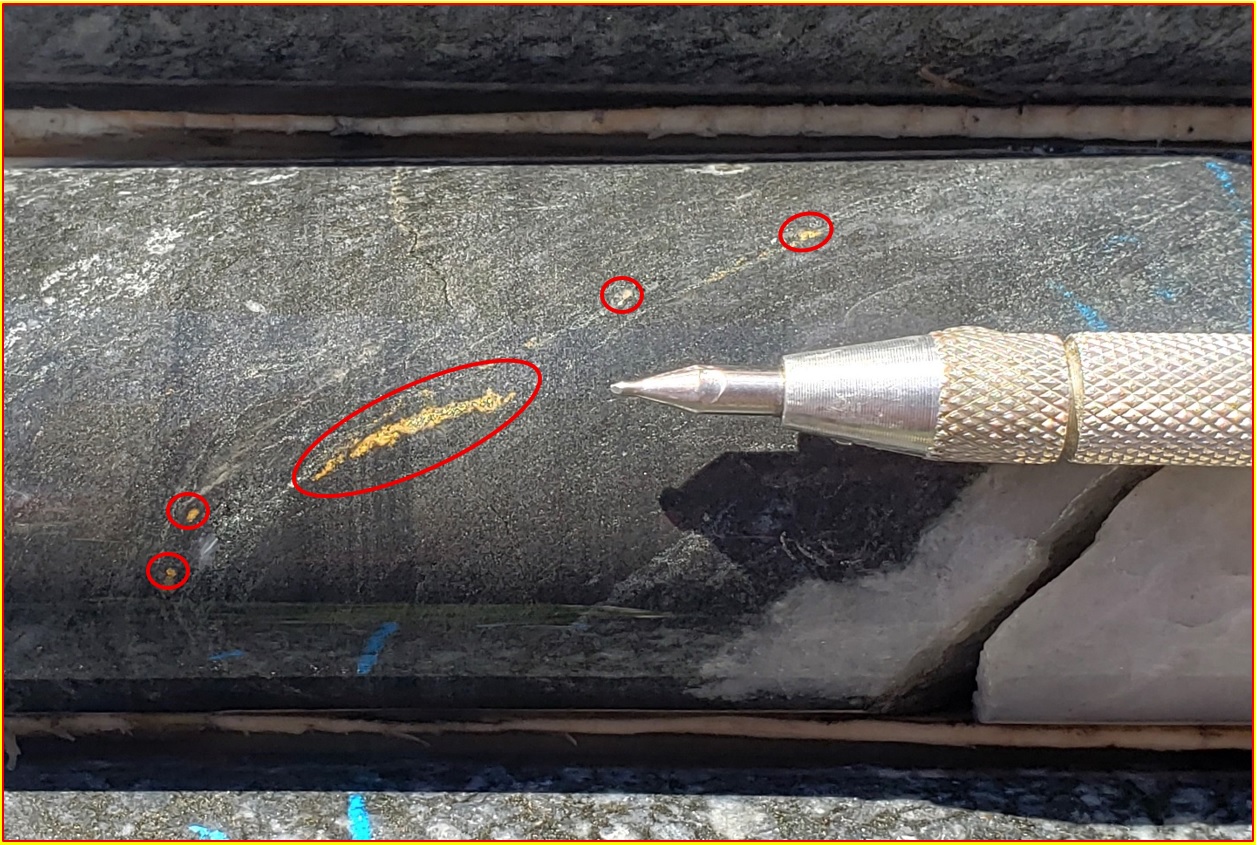
Figure 2: Visible Gold in the Interval 11.8-12.1 m, Hole GR-25-011 Which Assayed 308 g/t Au3
To view an enhanced version of this graphic, please visit:
https://images.newsfilecorp.com/files/10770/273050_ongold%20figure%202.jpg
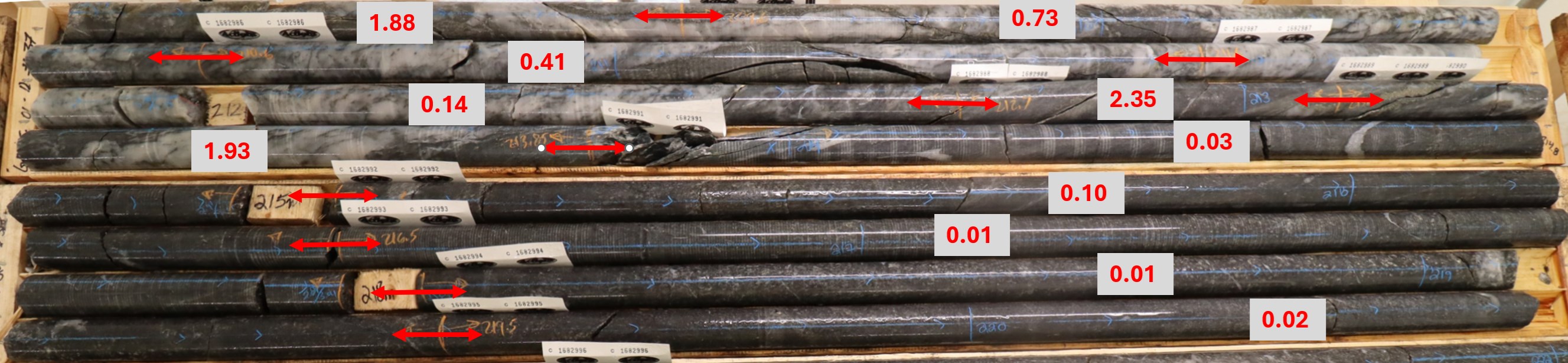
Figure 3: Quartz Vein Zone in GR-25-012 with Assays in g/t Au.
To view an enhanced version of this graphic, please visit:
https://images.newsfilecorp.com/files/10770/273050_3102b978a4e818ea_008full.jpg
Table 2: Gold Ridge 2025 Drilling Program
| Drillhole Name | Easting | Northing | Elevation | Azimuth | Dip | Length (m) |
| GR-25-008 | 432130 | 5823230 | 276 | 350 | 45 | 311 |
| GR-25-009 | 432055 | 5823323 | 272 | 170 | 86 | 110 |
| GR-25-010 | 432055 | 5823323 | 272 | 170 | 75 | 98 |
| GR-25-011 | 432055 | 5823323 | 272 | 170 | 50 | 80 |
| GR-25-012 | 430555 | 5822840 | 260 | 350 | 47 | 329 |
| GR-25-013 | 430555 | 5822840 | 260 | 20 | 47 | 329 |
| GR-25-014 | 432321 | 5824301 | 260 | 300 | 47 | 305 |
| GR-25-015 | 432321 | 5824301 | 270 | 120 | 45 | 305 |
| GR-25-016 | 433941 | 5823764 | 270 | 360 | 47 | 302 |
Property Geology
The TPK Property is located in the Mameigwess greenstone belt of Oxford-Stull domain of the Sachigo Superterrane. The Stull-Wunnumin Fault Zone ("SWFZ") is a regional-scale structure that forms the boundary between the Oxford-Stull terrane and the North Caribou terrane.
In the Gold Ridge area rocks mapped as mafic, intermediate and felsic volcanics and interbedded sediments have been intruded by early gabbro and quartz diorite/granodiorite complexes. The intrusions were in turn intruded by early mafic dykes (now often seen as chloritic shears) before being deformed.
Detailed mapping in the northern part of the Gold Ridge area confirmed the low gold values obtained by the previous operator, as well as finding new gold values over a larger area. Of 49 grab samples taken in the current program, 10 assayed higher than 50 ppb gold, 6 assayed higher than 350 ppb gold. One sample of a quartz vein assayed 2.85 g/t gold, while a sample of sheared quartz diorite approximately 13 m south of the vein assayed 2.59 g/t gold. Together these represent a new surface gold showing.
In the eastern part of the Gold Ridge area, sheared and silicified gabbro was seen in close proximity to a mafic volcanic/gabbro contact. This represents a separate target area, to be investigated in future exploration programs.
Mineralization throughout the Gold Ridge area is controlled by shears in the volcanic and intrusive rocks and consists of quartz veins and stringers, accompanied by disseminated pyrite, pyrrhotite and local chalcopyrite in chlorite-biotite alteration and local silicification. Low levels of gold, in the 10 ppb to 30 ppb range, are widespread in the diorite in the Discovery Zone area. Localized anomalous to highly anomalous gold values in outcrops and drilling are now known to occur over an area approximately 400 metres wide by 1,400 metres long along a NNE trending corridor in the Gold Ridge area. Taken together, these features are interpreted to indicate the presence of a large, intrusive-hosted, orogenic gold system. Such systems are known to host significant gold deposits in similar geologic terrains. Comparisons to other deposits or districts are not necessarily indicative of mineralization on the TPK property.
Qualified Person
The scientific and technical content of this press release has been reviewed and approved by Rodney Barber, P. Geo. for ONGold, who is a "Qualified Person" as defined by NI 43-101. Mr. Barber has verified the technical data disclosed in this news release by (i) overseeing core logging/sampling, (ii) reviewing laboratory certificates, and (iii) comparing collar/survey data to field records. Historical results were reviewed for reasonableness against original filings and available logs; limited verification has been performed and historical results should not be relied upon until confirmed. Mr. Barber is the President of ONGold and is not considered independent. Ongoing verification of scientific and technical information is achieved by direct involvement in the exploration work.
QA/QC Procedures
Quality Assurance/ Quality Control ("QA/QC") procedures were executed to ensure all work is conducted in accordance with best practices. Drill core was sawn in half with one half of the core prepared for shipment and the other half retained for future verification. Samples were placed into security-sealed bags for shipment. Drill core is BQTK size and sample intervals range from 0.3 metres to 1.5 metres in length. Commercially prepared certified reference material ("CRM") standards and blanks were inserted at a rate of 1 QA/QC sample in every 10 core samples. Samples were analyzed at the Activation Laboratories facility in Thunder Bay, Ontario which is ISO 17025 and ISO 9001 certified. Samples were initially analyzed by 50-gram fire assay with atomic absorption finish. Any sample assaying greater than 5 g/t gold was re-assayed by fire assay gravimetric analysis. Selected samples have been analyzed by screened metallics method.
About ONGold Resources Ltd.
ONGold Resources Ltd. owns significant exploration assets in Northern Ontario and Northern Manitoba, including the district-scale Monument Bay Gold and Tungsten Project, TPK Project, Domain Gold Project and October Gold Project. These projects represent a strategic footprint in one of Canada's most prolific gold-producing regions.
With its extensive technical expertise, strong commitment to social acceptability, mindful Indigenous engagement and partnerships, in addition to a proven track record of responsible exploration, ONGold's team is uniquely positioned to unlock the full potential of its portfolio of projects.
ONGold Resources Ltd. on behalf of the Board of Directors
Kyle Stanfield, Chief Executive Officer & Director
Contact Information
Kyle Stanfield
Chief Executive Officer
Telephone: 1 (855) 525-0992
Email: info@ongoldresources.com
Neither the TSX Venture Exchange nor its Regulation Services Provider (as that term is defined in the policies of the TSX Venture Exchange) accepts responsibility for the adequacy or accuracy of this release.
Cautionary Note Regarding Forward-Looking Information
This news release contains "forward-looking information" within the meaning of applicable Canadian securities legislation, including statements regarding: the nature, extent and interpretation of mineralization at Gold Ridge and the TPK project; the presence or potential of an intrusive-hosted, orogenic gold system; the significance of till, boulder and drilling results; the timing and disclosure of pending assays (including base-metals/multi-element data); the potential dimensions and continuity of mineralized corridors; and the Company's plans for follow-up exploration programs and objectives.
Forward-looking information is based on a number of assumptions that, while considered reasonable by ONGold as of the date of this release, are inherently subject to significant business, technical and economic uncertainties and contingencies. Assumptions include: the representativeness and reliability of sampling and analytical results; that historical information is fairly reported; the availability and performance of laboratories; that planned exploration can be executed as designed; access, weather and logistical conditions; the availability of financing, personnel and equipment; and stable market and regulatory conditions.
Forward-looking information is subject to known and unknown risks, uncertainties and other factors that may cause actual results to differ materially from those expressed or implied, including, without limitation: early-stage exploration risk; uncertainty of geological interpretations and continuity; the preliminary nature of results (true widths unknown; no mineral resources defined); that sampling (till, grab and selected core intervals) may be selective and not representative; assay variability and delays; risks related to community and Indigenous engagement and permitting; access, weather and logistical constraints in remote areas; commodity price and currency fluctuations; capital markets and financing risk; regulatory changes; and the other risks set out under "Risk Factors" in the Company's continuous disclosure filings available at www.sedarplus.ca.
Readers are cautioned not to place undue reliance on forward-looking information. ONGold undertakes no obligation to update any forward-looking information, except as required by applicable securities laws.
1 Dimensions reflect field and drilling observations to date; true widths are not yet known.
2 Till and boulder sampling are selective by nature and may not be representative of mineralization on the property. These results are historical in nature and were generated by a previous operator. While the Company and its Qualified Person (as such term is defined in National Instrument 43-101 - Standards of Disclosure in Mineral Projects ("NI 43-101")) have reviewed the available information, they have not independently verified all historical results and such results should not be relied upon until confirmed by current work.
3 Photographs of core are selective and may not be representative of mineralization.
![]()
To view the source version of this press release, please visit https://www.newsfilecorp.com/release/273050
Source: ONGold Resources Ltd.