Highlights:
- Mineralized system at the Cruz de Plata ("CDP") project is significantly larger than previously outlined.
- Cumulative silver-mineralized vein structures have grown to more than 20km from 7km (previously announced on May 24, 2023). These structures have been identified from surface sampling and mapping on the newly consolidated land package.
- A large granodiorite intrusion identified to the north of the main Jésus María trend is a key feature for locating mineralization at Cruz de Plata, with the main silver trend now found to wrap around the intrusion on its western and northern contact within the folded sedimentary package.
- All known lithologies at the CDP project contain precious and base metal mineralization.
- Six (6) new priority targets identified and being advanced to the drill-ready stage.
- Property-wide geophysical survey commissioned and should be completed by Q1 2026.
- Assays pending for 38 reverse-circulation ("RC") drill holes with additional holes being drilled every week.
- Fully Funded Phase 1 Drill Program expanded by 50% to 15,000m.
Vancouver, British Columbia--(Newsfile Corp. - October 1, 2025) - Capitan Silver Corp. (TSXV: CAPT) ("Capitan" or "the Company") is pleased to provide an update for its Cruz de Plata silver-gold project, located in Durango, Mexico. The Company reported today that a surface exploration campaign on the newly acquired 2,171-hectare strategic land package (See Company press release dated August 22, 2025) has identified several new high-priority targets and high-grade mineral showings that include significant extensions to known mineral structures, which the Company is now advancing to the drill-ready stage.
These discoveries are significant as they validate management's thesis that the hydrothermal system at Cruz de Plata is much larger than what was previously known, with the mineral footprint and structures now shown to extend several kilometres to the north of the current limits of the 2025 drill program. A key takeaway is that mineralization is observed to be hosted within all known geological units identified at Cruz de Plata, further increasing the potential for new targets, and increasing the potential of the property.
Alberto Orozco, CEO of Capitan Silver, commented: "The continued growth and evolution of Cruz de Plata has been tremendously exciting for the Company. What began as a handful of isolated silver targets has expanded into a much larger mineralized system. The new detailed geological map and surface sampling highlights how robust the Cruz de Plata system can be, while immediately giving us multiple new targets to aggressively move to a drill-ready stage. We would also like to announce that we are upsizing our Phase One Drill Program by 50%, for a total of 15,000 metres, which is fully funded.
Mr. Orozco continued, "the airborne geophysical survey that the Company has commissioned, will be the first property-wide initiative for target generation and expansion by covering the entire project area with new and detailed geophysical data."
Property Consolidation Summary
The Company's original (2020) property package contained two isolated high-grade silver vein targets, Jésus María and San Rafael, as well as the disseminated gold target (Capitan Hill) to the south of the Jésus María showings. In 2022, Capitan completed its first property acquisition at Cruz de Plata, growing the property by 261.42 hectares and connecting the Jésus María and San Rafael targets, which formed the Jésus María silver trend (See Company press release dated December 6, 2022). On August 22, 2025, the Company announced the acquisition of a key property covering a total surface of 2,171.4 hectares, completing the consolidation of the Cruz de Plata property package (See Figure 1). Prior to the latest acquisition, the Company conducted a detailed mapping and surface sampling program that, together with the newly acquired data from the previous operator, has formed the basis of a new understanding of the controls of the mineral system and the discovery of multiple new targets. Figure 1 below shows the starting and current land position for the Cruz de Plata project.
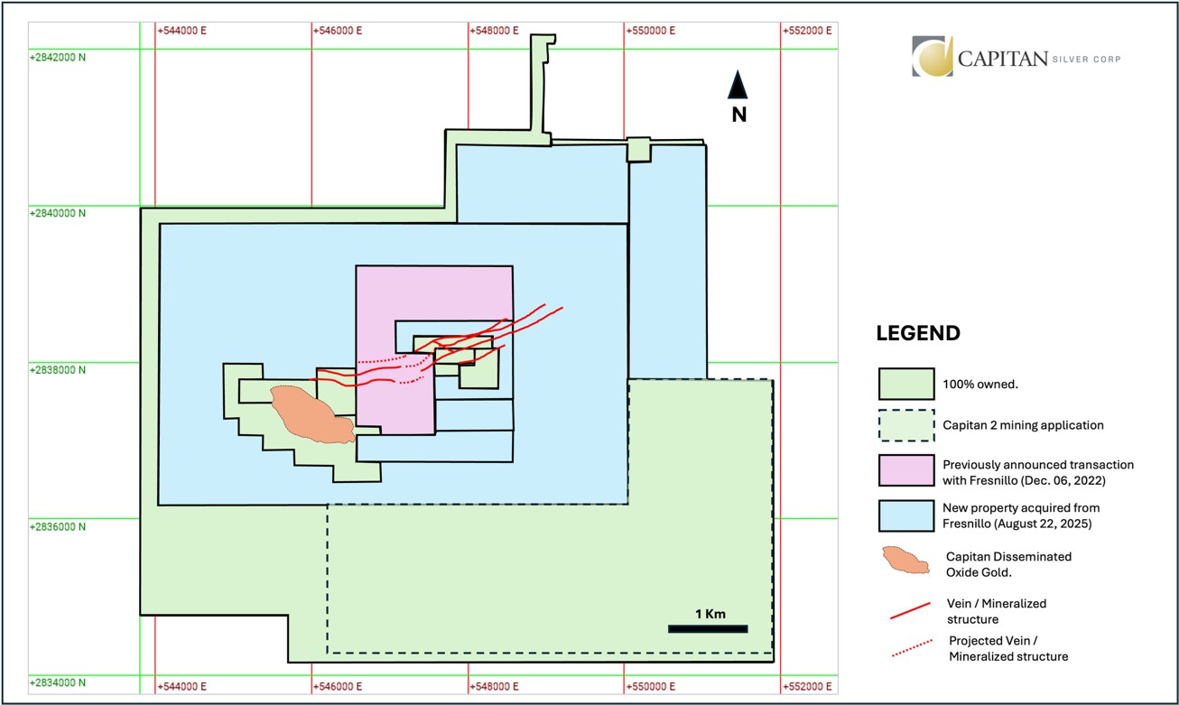
Figure 1: Capitan Silver's original land position in 2020 for the Cruz de Plata silver-gold project is shown in green with the strategic acquisitions in 2022 and 2025 shown in pink and blue respectively.
To view an enhanced version of this graphic, please visit:
https://images.newsfilecorp.com/files/7373/268684_5292b213f48e7878_002full.jpg
Cruz de Plata - Geological Thesis
Through detailed mapping and sampling, the Capitan exploration team has recognized a spatial correlation between the 3.7km Jesús María silver trend along the southern periphery of an east-northeast trending-elongated granodiorite intrusive body and a similar environment to its north. Exploration crews systematically followed this contact with further mapping and sampling to evaluate the possibility of the silver mineralization continuing along the entire contact of the granodiorite intrusive and the sediments. Results of this survey, which also included compilation data from previous operators, validated this hypothesis (See Figure 2).
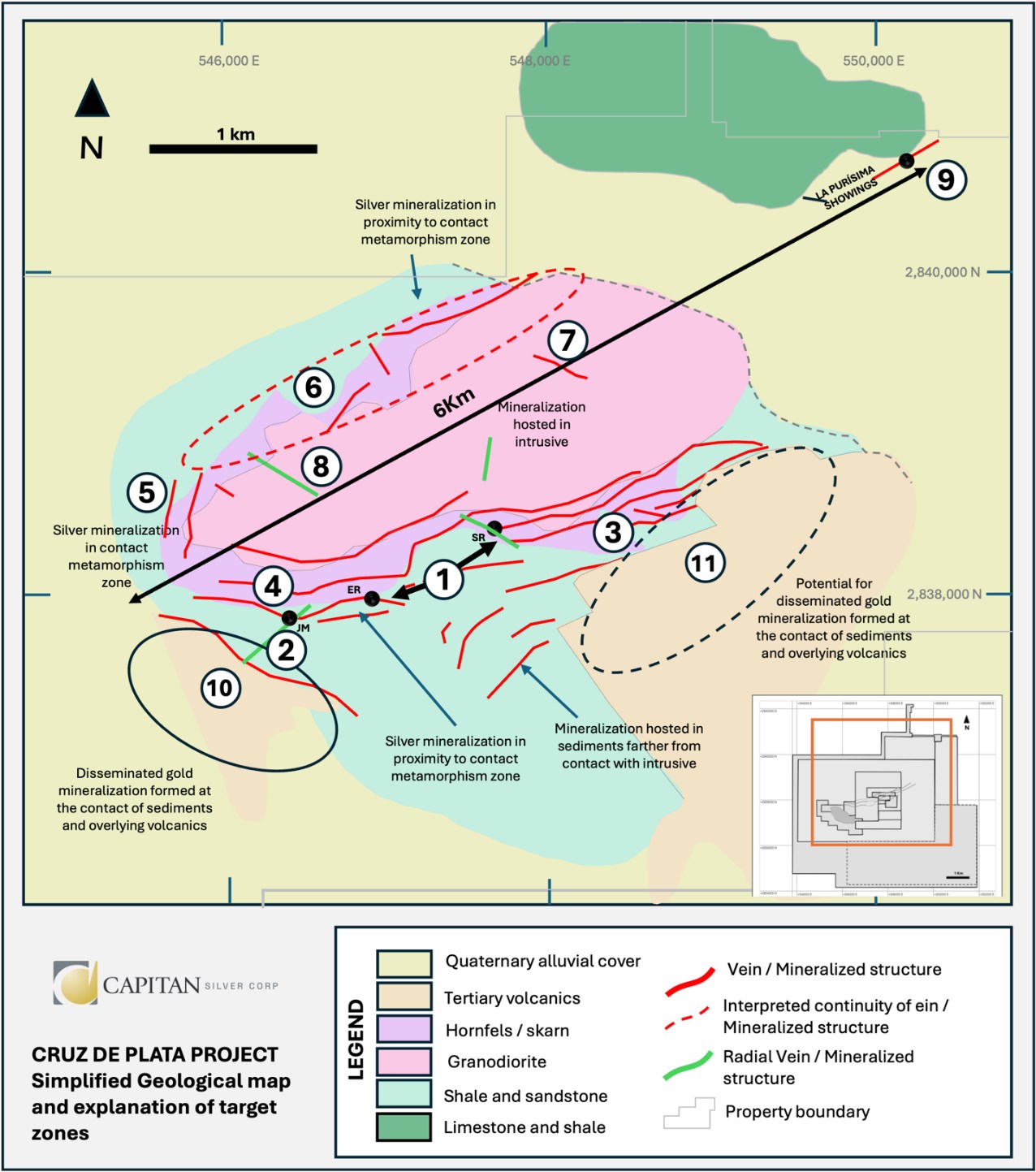
Figure 2: Simplified geological map and mineral system model, including new identified targets. 1. Jesús María silver trend (Containing the Jésus María , Santa Teresa and San Rafael veins), 2. Gully Fault zone, 3. Jésus María East trend, 4. San Rafael West, 5. Jésus María Northwest, 6. Casco Norte, 7. La Providencia, 8. Jésus María silver trend north, 9. La Purísima, 10. Capitan Hill gold deposit, 11. El Tubo Hill gold target.
To view an enhanced version of this graphic, please visit:
https://images.newsfilecorp.com/files/7373/268684_5292b213f48e7878_003full.jpg
The current geological thesis suggests that the genesis of the hydrothermal mineralization at Cruz de Plata occurs somewhere below the granodiorite, with the documented radial fractures in the intrusive unit being the main conduit transporting the mineralization across the property. As the mineralized fluids reach the sediment rock package, they form the silver vein trend in a combination of replacement zones and hydrothermal breccias. As mineralized fluids continue to flow further away from the source along these radial fractures and cross the boundary of the Tertiary volcanic unit, this is where the Company believes the gold mineralization is deposited (in the cooler temperature part of the mineralized system - Capitan Hill). This potentially explains the relationship of the Gully Fault (believed to be one of several key radial fractures) to both the Jésus María silver vein trend and the Capitan Hill gold deposit.
Recent Surface Exploration and New Discoveries
Capitan's exploration team conducted a reconnaissance-scale surface evaluation of the newly acquired land package consisting of mapping, surface trenching and soil sampling, with the objective of identifying new targets. Early field work provided further evidence of structural and lithological controls for silver and gold mineralization; mainly the silver system emplacing around and proximal to the contact with an intrusive granodiorite body (Figure 2). In addition to identifying high-grade silver mineralization around the granodiorite intrusive, the Company has identified the potential for the silver zone to grow via radial structures cross-cutting the granodiorite intrusion. Strong silver and gold grades have been returned from prospecting and are described below. Additionally, the Company has defined the lithological contact between the folded sedimentary package and the overlying, younger volcanic rock package across the easternmost portion of the property package. This environment is prospective for additional disseminated gold mineralization, similar to what is found at Capitan Hill.
Prior to the commencement of the surface program, Capitan commissioned a new high-resolution Digital Terrain Model ("DTM") and satellite image from Pacific Geomatics of Vancouver, BC to help field crews identify old historic workings and areas of potential outcrop. This provided field crews with a more efficient method of evaluating the property and led to a reduction in the time spent seeking these new targets.
This program, still in its early stages, has resulted in the discovery of at least six (6) new mineral showings, including significant extensions to known mineralized structures across the newly acquired land package, which are described below (Figure 3).
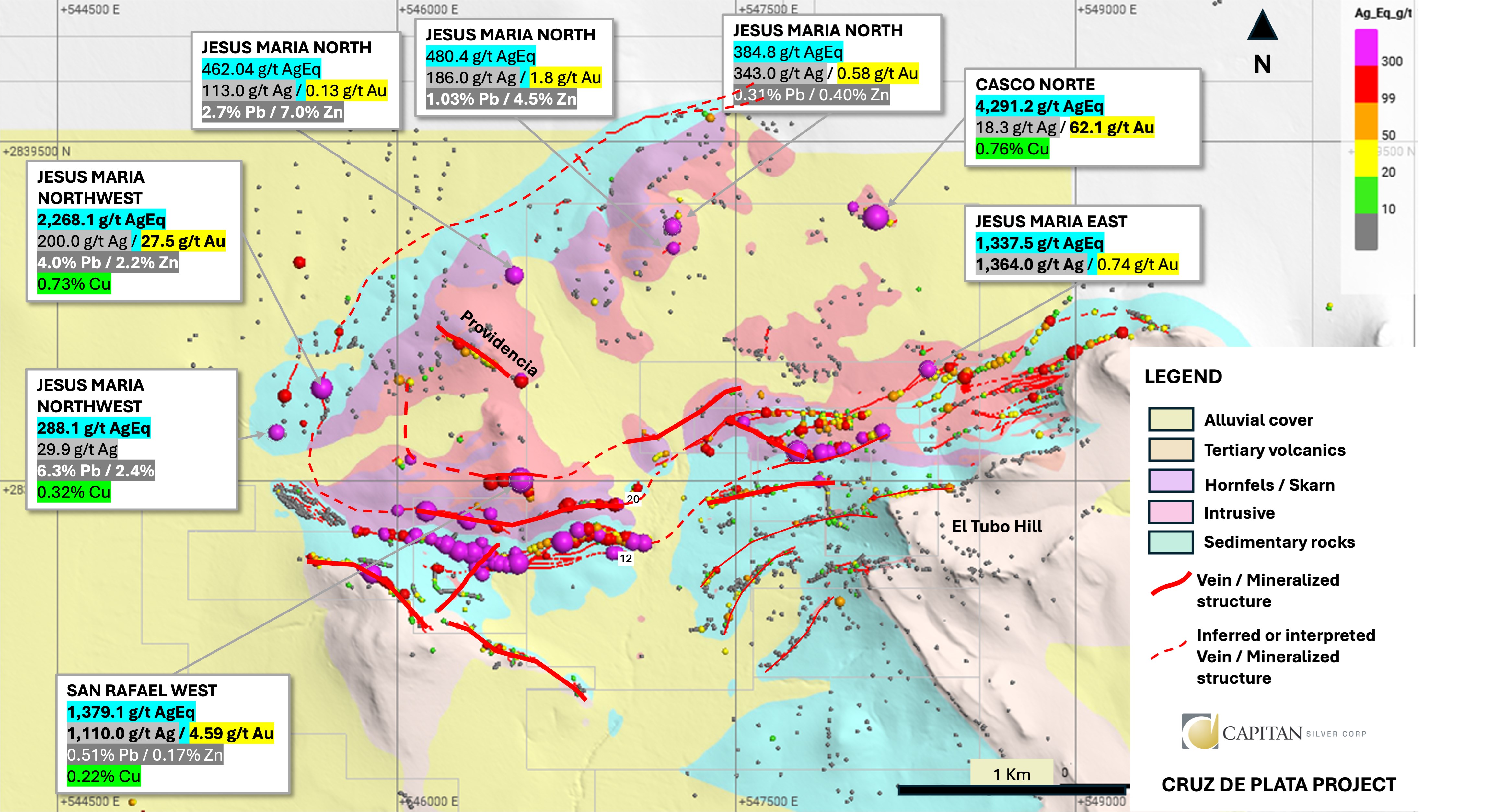
Figure 3. Detailed view of new project concept with sampling highlights.
To view an enhanced version of this graphic, please visit:
https://images.newsfilecorp.com/files/7373/268684_5292b213f48e7878_004full.jpg
Description of Targets
Casco Norte (High-grade Gold and Silver) - NEW
Casco Norte is located in the central portion of the newly consolidated property package (See Figures 2 & 3) and consists of a series of workings and pits that trend roughly west-northwest, and has been traced along strike for 150m. Mineralization consists of sheared and brecciated, strongly silicified granitic to granodioritic intrusive that is at least 3-4m in width. A series of grab and chip samples were taken across the old workings, which returned moderate to high-grade Au values, ranging from trace to the best value returning 4,291.2 g/t AgEq (See Table 1). Despite the low topographic relief of the area, overburden depth is surprisingly thin, which will allow for further surface exploration work, including mechanical trenching. Follow-up work will begin on this target in the next several weeks.
Jésus María Northwest - NEW
Jésus María Northwest is located along the north contact of the sediment-granitic intrusive boundary, approximately 400-500m northwest of the western most drillholes of the main Jésus María silver zone. The showing consists of an old mine working in an area of low topographic relief, with little outcrop, that trends roughly north-northwest. Capitan geologists were able to enter the old workings and obtain a sample for analysis and have confirmed that mineralization closely resembles the main Jésus María zone. This discovery is significant as it extends the Jésus María zone approximately 800m to the west and north, suggesting it wraps around the main granodioritic intrusive body. Sampling from the main showing returned significant values ranging from trace to high-grade values with the best value returning 2,268.1 g/t AgEq (See Table 1). Follow-up work will continue in this area and will include soil geochemistry, possible mechanical trenching, and geophysics.
Jésus María East - NEW
The extension of the Jésus María silver trend to the east hosts the historic San Rafael mine and has seen small amounts of drilling by Capitan in 2022. Capitan geologists have traced similar style mineralization onto the newly consolidated land package, adding approximately 1.2km of strike to this zone. A series of grab and chip samples have been taken along this zone, with analysis returning values ranging from trace to high-grade mineralization with the best value returning 1,337.5 g/t AgEq. Additional surface work in this area will include mapping and mechanical trenching to upgrade this target to the drill-ready stage.
San Rafael West - NEW
The San Rafael West zone is the northernmost of the veins and structures that are part of the east-west trending Jésus María silver trend. This zone is located just to the north and west of the El Casco Property boundary, approximately 500m to the north of the Jésus María showings (See Figures 2 & 3). High-grade silver mineralization has been traced over a strike length of approximately 150m with grab and chip samples ranging from trace to high-grade with the best value of 1,379.1 g/t AgEq being returned (See Table 1). Mineralization is hosted in hornfelsed sediments, very proximal to the sedimentary granite intrusive boundary. This target remains open along strike to the east-and west.
La Providencia
La Providencia consists of a series of pits and shallow workings that trend northwest and can be traced along strike for approximately 400m. Mineralization is hosted in sheared and brecciated granodioritic intrusive and dips steeply to the southwest. Capitan geologists have taken a series of chip and grab samples within the workings and along the surface expression of the veins at higher elevations. The best values returned include 381.6 g/t AgEq. Additional surface work, including mechanical trenching, will be conducted at this target to upgrade it to drill-ready stage.
La Purisima - NEW
The La Purisima showing is located within the northeastern portion of the Capitan claim group, approximately 4.5km northeast of the main Jésus María trend (See Figures 2 & 3). This portion of the mining claim group was - until recently - quite isolated, with little incentive to explore further due to the very small size of the surrounding mining claim (approximately 200m north-south in dimension). The recent property consolidation has changed these circumstances significantly with the infilling of the property to the south. As a result, field crews were sent to evaluate this area further.
La Purisima occurs at the northern contact between the granodioritic intrusive and limestone sediments, with mineralization resembling more of a skarn-like appearance, from the limited exposure observed at this time. The showing consists of a series of old pits and shafts that occur in an area of very low topographic relief, over a strike length of approximately 50m. Grab and chip samples from this area returned polymetallic Au-Ag-Cu-Pb-Zn, with values ranging from trace to 241.6 g/t AgEq. Follow-up work will continue, in this area with additional prospecting, and possible mechanical trenching.
Jésus María North - NEW
This target consists of east-northeast and northwest striking structures that have been mapped and sampled in the sedimentary unit, along the north contact of the intrusive. Outcrop in this area is minimal, so future exploration targeting will rely on expanding the soil geochemistry program and airborne geophysics.
El Tubo Hill Gold
The El Tubo Hill contains a very similar stratigraphy to the Capitan Hill oxide gold deposit where Tertiary volcanics rest unconformably over the deformed sedimentary unit. At Capitan Hill, the contact between the two units is marked by the Capitan vein, with mineralization then expanding from that point both underneath into the sediments and above towards the volcanics, forming a large volume of gold mineralization. At El Tubo, low-grade gold mineralization has been identified in outcrop, along the contact between the two units. Additionally, soil geochemical sampling returned anomalous values over a strike length of approximately 500m.
Expanded 2025 Drilling Program
The Company is pleased to report that it will be upsizing its 2025 Phase One Drilling Program from 10,000m to 15,000m. Capitan has completed just over 8,000m of drilling to date, with assays pending for 38 drill holes. With new drill holes being delivered to the lab weekly, the Company will continue to update the market as assay results are received.
Airborne Geophysical Program
Capitan is pleased to report that it has engaged the services of Expert Geophysics Services of Newmarket, Ontario, to complete a property-wide 385 line-km regional airborne magnetic and magneto-telluric survey. The results generated from this survey will include magnetic maps and their various derivatives, as well as apparent conductivity and resistivity maps that can be used to help identify new alteration zones, geological features and lithologies, and extensions of existing zones (including fault structures), up to depths of 1km.
Table 1: Grab and Chip Sample Highlights from Prospecting Program
| Easting | Northing | Au_ppm | Ag_ppm | Cu% | Pb% | Zn% | AgEq (g/t) | Zone |
| 548116 | 2839164 | 62.1 | 18.3 | 0.76 | 0.02 | 0.02 | 4291.17 | Casco North |
| 547221 | 2839029 | 1.8 | 186 | 0.03 | 1.03 | 4.49 | 480.41 | Casco North |
| 547217 | 2839124 | 0.584 | 343 | 0.04 | 0.31 | 0.40 | 384.78 | Casco North |
| 548015 | 2839210 | 4.16 | 7.8 | 0.02 | 0.00 | 0.00 | 293.78 | Casco North |
| 547219 | 2839032 | 0.518 | 133 | 0.01 | 2.11 | 0.61 | 240.61 | Casco North |
| 547221 | 2839031 | 1.011 | 87.4 | 0.02 | 0.47 | 1.87 | 228.55 | Casco North |
| 548090 | 2839128 | 0.588 | 8.8 | 0.01 | 0.01 | 0.01 | 49.09 | Casco North |
| 548183 | 2839145 | 0.442 | 16.1 | 0.01 | 0.01 | 0.01 | 45.95 | Casco North |
| 548090 | 2839132 | 0.463 | 6.3 | 0.01 | 0.00 | 0.00 | 37.96 | Casco North |
| 548182 | 2839146 | 0.397 | 10.8 | 0.00 | 0.01 | 0.00 | 37.75 | Casco North |
| 548183 | 2839145 | 0.32 | 11.9 | 0.00 | 0.01 | 0.01 | 33.58 | Casco North |
| 548186 | 2839146 | 0.239 | 12.3 | 0.00 | 0.01 | 0.00 | 28.31 | Casco North |
| 548185 | 2839146 | 0.25 | 8.7 | 0.01 | 0.01 | 0.00 | 25.68 | Casco North |
| 548076 | 2839199 | 0.347 | 0.7 | 0.01 | 0.00 | 0.01 | 24.81 | Casco North |
| 548178 | 2839138 | 0.212 | 10.3 | 0.00 | 0.01 | 0.00 | 24.55 | Casco North |
| 547060 | 2838918 | 0.3 | 0.15 | 0.04 | 0.00 | 0.00 | 20.89 | Casco North |
| 548347 | 2838492 | 0.744 | 1364 | 0.04 | 0.09 | 0.05 | 1337.50 | JM East |
| 548509 | 2838457 | 0.132 | 198 | 0.00 | 0.01 | 0.01 | 195.74 | JM East |
| 548990 | 2838564 | 2.54 | 4.8 | 0.00 | 0.00 | 0.00 | 179.30 | JM East |
| 549206 | 2838654 | 1.845 | 0.25 | 0.00 | 0.00 | 0.01 | 127.55 | JM East |
| 549009 | 2838575 | 1.615 | 6.7 | 0.00 | 0.00 | 0.00 | 117.44 | JM East |
| 548442 | 2838500 | 0.513 | 64.4 | 0.00 | 0.00 | 0.01 | 96.10 | JM East |
| 548434 | 2838323 | 0.04 | 97.4 | 0.00 | 0.00 | 0.00 | 94.43 | JM East |
| 548886 | 2838705 | 0.159 | 88.1 | 0.00 | 0.01 | 0.01 | 94.21 | JM East |
| 548526 | 2838471 | 0.019 | 97 | 0.01 | 0.01 | 0.01 | 93.02 | JM East |
| 548859 | 2838490 | 1.22 | 8.5 | 0.00 | 0.00 | 0.00 | 91.96 | JM East |
| 548814 | 2838369 | 0.902 | 27.1 | 0.00 | 0.00 | 0.00 | 87.59 | JM East |
| 548521 | 2838478 | 1.08 | 9.3 | 0.00 | 0.00 | 0.01 | 83.46 | JM East |
| 548347 | 2838492 | 0.12 | 70.3 | 0.00 | 0.00 | 0.00 | 74.62 | JM East |
| 548435 | 2838321 | 0.008 | 78.5 | 0.00 | 0.00 | 0.00 | 74.41 | JM East |
| 549067 | 2838602 | 0.954 | 1.5 | 0.01 | 0.00 | 0.01 | 67.24 | JM East |
| 548868 | 2838680 | 0.205 | 46.9 | 0.01 | 0.01 | 0.01 | 58.67 | JM East |
| 548517 | 2838467 | 0.066 | 56.7 | 0.00 | 0.00 | 0.00 | 58.05 | JM East |
| 548868 | 2838683 | 0.237 | 44.1 | 0.00 | 0.00 | 0.01 | 58.01 | JM East |
| 548665 | 2838528 | 0.537 | 19.8 | 0.00 | 0.00 | 0.00 | 55.69 | JM East |
| 549331 | 2838675 | 0.798 | 0.4 | 0.00 | 0.00 | 0.01 | 55.47 | JM East |
| 548664 | 2838530 | 0.591 | 12.5 | 0.00 | 0.00 | 0.00 | 52.55 | JM East |
| 548487 | 2838551 | 0.412 | 23.5 | 0.00 | 0.00 | 0.00 | 50.69 | JM East |
| 548642 | 2838515 | 0.468 | 19.2 | 0.00 | 0.00 | 0.00 | 50.39 | JM East |
| 548460 | 2838480 | 0.53 | 8.9 | 0.00 | 0.00 | 0.00 | 44.94 | JM East |
| 548511 | 2838474 | 0.512 | 8.3 | 0.00 | 0.00 | 0.01 | 43.24 | JM East |
| 548434 | 2838498 | 0.443 | 12.5 | 0.00 | 0.00 | 0.00 | 42.31 | JM East |
| Easting | Northing | Au_ppm | Ag_ppm | Cu% | Pb% | Zn% | AgEq (g/t) | Zone |
| 548421 | 2838449 | 0.566 | 2.9 | 0.00 | 0.00 | 0.01 | 41.92 | JM East |
| 548510 | 2838455 | 0.153 | 30.5 | 0.00 | 0.00 | 0.01 | 39.50 | JM East |
| 548526 | 2838468 | 0.008 | 40.7 | 0.00 | 0.00 | 0.00 | 39.06 | JM East |
| 549334 | 2838675 | 0.51 | 1.2 | 0.00 | 0.00 | 0.01 | 36.45 | JM East |
| 548357 | 2838455 | 0.469 | 1.9 | 0.00 | 0.00 | 0.00 | 34.16 | JM East |
| 549320 | 2838715 | 0.266 | 16.7 | 0.00 | 0.00 | 0.00 | 34.11 | JM East |
| 548731 | 2838293 | 0.039 | 32.3 | 0.01 | 0.00 | 0.00 | 33.17 | JM East |
| 549139 | 2838631 | 0.471 | 0.7 | 0.00 | 0.00 | 0.00 | 33.14 | JM East |
| 548692 | 2838551 | 0.274 | 14.6 | 0.00 | 0.00 | 0.01 | 32.80 | JM East |
| 548376 | 2838461 | 0.185 | 21 | 0.00 | 0.00 | 0.01 | 32.67 | JM East |
| 548840 | 2838202 | 0.454 | 0.9 | 0.02 | 0.00 | 0.01 | 32.43 | JM East |
| 548668 | 2838521 | 0.11 | 26.1 | 0.00 | 0.00 | 0.00 | 32.29 | JM East |
| 548524 | 2838474 | 0.245 | 15.7 | 0.00 | 0.00 | 0.00 | 31.73 | JM East |
| 548421 | 2838448 | 0.319 | 8.7 | 0.00 | 0.00 | 0.01 | 30.42 | JM East |
| 548616 | 2838509 | 0.008 | 30.4 | 0.00 | 0.00 | 0.01 | 29.42 | JM East |
| 549391 | 2838673 | 0.409 | 0.25 | 0.00 | 0.00 | 0.01 | 28.57 | JM East |
| 548432 | 2838317 | 0.024 | 28.4 | 0.00 | 0.00 | 0.00 | 28.43 | JM East |
| 548814 | 2838617 | 0.128 | 20.2 | 0.01 | 0.00 | 0.00 | 27.86 | JM East |
| 548367 | 2838463 | 0.381 | 1.5 | 0.00 | 0.00 | 0.00 | 27.82 | JM East |
| 548715 | 2838290 | 0.168 | 17 | 0.00 | 0.00 | 0.00 | 27.60 | JM East |
| 548700 | 2838535 | 0.147 | 18.3 | 0.00 | 0.00 | 0.00 | 27.43 | JM East |
| 549111 | 2838622 | 0.389 | 0.5 | 0.00 | 0.00 | 0.00 | 27.33 | JM East |
| 548390 | 2838374 | 0.052 | 24.8 | 0.00 | 0.00 | 0.01 | 27.27 | JM East |
| 548418 | 2838449 | 0.354 | 2.8 | 0.00 | 0.00 | 0.00 | 27.15 | JM East |
| 548448 | 2838482 | 0.258 | 9.7 | 0.00 | 0.00 | 0.00 | 26.95 | JM East |
| 549391 | 2838671 | 0.385 | 0.25 | 0.00 | 0.00 | 0.00 | 26.82 | JM East |
| 548375 | 2838459 | 0.204 | 12 | 0.00 | 0.00 | 0.00 | 25.40 | JM East |
| 548390 | 2838479 | 0.348 | 0.8 | 0.00 | 0.00 | 0.00 | 24.76 | JM East |
| 548488 | 2838441 | 0.061 | 21.5 | 0.00 | 0.00 | 0.00 | 24.57 | JM East |
| 548445 | 2838458 | 0.319 | 2.3 | 0.01 | 0.00 | 0.00 | 24.29 | JM East |
| 548839 | 2838656 | 0.144 | 13.9 | 0.00 | 0.00 | 0.01 | 23.18 | JM East |
| 548309 | 2838339 | 0.041 | 21.3 | 0.00 | 0.00 | 0.01 | 23.05 | JM East |
| 548376 | 2838364 | 0.287 | 2.7 | 0.00 | 0.00 | 0.00 | 22.38 | JM East |
| 548823 | 2838628 | 0.097 | 16.3 | 0.00 | 0.00 | 0.00 | 22.17 | JM East |
| 548693 | 2838548 | 0.19 | 8.8 | 0.00 | 0.00 | 0.00 | 21.47 | JM East |
| 548676 | 2838283 | 0.243 | 4.6 | 0.01 | 0.00 | 0.00 | 21.12 | JM East |
| 548640 | 2838521 | 0.042 | 19 | 0.00 | 0.00 | 0.01 | 21.00 | JM East |
| 548445 | 2838457 | 0.211 | 6.6 | 0.01 | 0.00 | 0.00 | 20.78 | JM East |
| 549246 | 2838636 | 0.289 | 0.25 | 0.00 | 0.00 | 0.00 | 20.22 | JM East |
| 545667 | 2838409 | 27.5 | 200 | 0.73 | 4.00 | 2.23 | 2268.11 | JM Ext West |
| 545664 | 2838407 | 1.5 | 991 | 0.06 | 2.98 | 1.91 | 1183.35 | JM Ext West |
| 545667 | 2838404 | 2.99 | 122 | 0.75 | 4.50 | 2.59 | 534.78 | JM Ext West |
| 545664 | 2838407 | 0.187 | 186 | 0.04 | 2.90 | 6.86 | 502.57 | JM Ext West |
| 545676 | 2838403 | 0.692 | 136 | 0.12 | 2.28 | 2.79 | 334.38 | JM Ext West |
| Easting | Northing | Au_ppm | Ag_ppm | Cu% | Pb% | Zn% | AgEq (g/t) | Zone |
| 545466 | 2838213 | 0.028 | 29.9 | 0.32 | 6.25 | 2.43 | 288.06 | JM Ext West |
| 545506 | 2838377 | 0.151 | 54.1 | 0.07 | 3.84 | 0.65 | 191.08 | JM Ext West |
| 545503 | 2838375 | 0.188 | 33.5 | 0.16 | 2.34 | 1.87 | 173.55 | JM Ext West |
| 545586 | 2838253 | 0.04 | 14.2 | 0.10 | 2.09 | 0.53 | 92.77 | JM Ext West |
| 546009 | 2838444 | 0.018 | 4.4 | 0.03 | 0.11 | 2.13 | 80.99 | JM Ext West |
| 546058 | 2838435 | 0.007 | 14.1 | 0.01 | 0.90 | 0.12 | 43.12 | JM Ext West |
| 546010 | 2838444 | 0.033 | 2.9 | 0.02 | 0.03 | 0.68 | 28.75 | JM Ext West |
| 546500 | 2838900 | 0.13 | 113 | 0.00 | 2.70 | 7.00 | 462.04 | JM North |
| 547697 | 2839712 | 0.072 | 76.6 | 0.01 | 0.00 | 0.01 | 77.35 | JM North |
| 547242 | 2839175 | 0.238 | 59 | 0.01 | 0.04 | 0.09 | 75.83 | JM North |
| 547385 | 2839605 | 0.072 | 45.5 | 0.00 | 0.07 | 0.25 | 58.17 | JM North |
| 547250 | 2839243 | 0.243 | 25.2 | 0.01 | 0.02 | 0.04 | 42.35 | JM North |
| 548033 | 2839846 | 0.509 | 5.3 | 0.00 | 0.00 | 0.00 | 40.12 | JM North |
| 547243 | 2839172 | 0.051 | 23.4 | 0.01 | 0.02 | 0.06 | 28.14 | JM North |
| 547722 | 2839711 | 0.193 | 14.8 | 0.00 | 0.00 | 0.00 | 27.28 | JM North |
| 545744 | 2838658 | 0.106 | 79.3 | 0.04 | 1.92 | 0.57 | 155.09 | JM North |
| 545567 | 2838967 | 0.046 | 112 | 0.00 | 0.03 | 0.21 | 116.34 | JM North |
| 545569 | 2838965 | 0.035 | 114 | 0.01 | 0.08 | 0.10 | 115.37 | JM North |
| 545564 | 2838960 | 0.282 | 29.1 | 0.03 | 0.17 | 0.29 | 61.15 | JM North |
| 545739 | 2838657 | 0.021 | 8.4 | 0.01 | 0.42 | 0.12 | 24.94 | JM North |
| 546548 | 2838451 | 0.317 | 357 | 0.04 | 0.64 | 0.18 | 381.62 | Providencia |
| 546548 | 2838440 | 0.082 | 196 | 0.03 | 0.24 | 0.14 | 201.36 | Providencia |
| 546273 | 2838605 | 0.059 | 111 | 0.01 | 0.43 | 0.21 | 127.51 | Providencia |
| 546424 | 2838515 | 0.107 | 32.4 | 0.02 | 0.22 | 0.75 | 69.56 | Providencia |
| 546236 | 2838632 | 0.113 | 39.9 | 0.05 | 0.13 | 0.41 | 62.83 | Providencia |
| 546301 | 2838569 | 0.034 | 51.8 | 0.01 | 0.12 | 0.11 | 58.26 | Providencia |
| 546404 | 2838524 | 0.049 | 26.9 | 0.01 | 0.16 | 0.28 | 42.66 | Providencia |
| 546404 | 2838522 | 0.037 | 25.1 | 0.02 | 0.26 | 0.24 | 41.48 | Providencia |
| 546234 | 2838632 | 0.015 | 19.4 | 0.04 | 0.13 | 0.22 | 30.57 | Providencia |
| 546422 | 2838513 | 0.08 | 10.3 | 0.01 | 0.11 | 0.12 | 22.22 | Providencia |
| 550192 | 2840697 | 1.98 | 76 | 0.07 | 1.86 | 2.34 | 339.35 | Purisima |
| 550205 | 2840690 | 1.856 | 43.7 | 0.10 | 1.99 | 0.50 | 241.60 | Purisima |
| 550199 | 2840711 | 0.886 | 26.8 | 0.02 | 0.88 | 0.94 | 142.93 | Purisima |
| 546545 | 2838001 | 4.59 | 1110 | 0.22 | 0.51 | 0.17 | 1379.07 | San Rafael West |
| 546472 | 2838002 | 0.518 | 443 | 0.11 | 0.15 | 0.24 | 464.50 | San Rafael West |
| 546416 | 2837990 | 0.355 | 218 | 0.10 | 0.57 | 0.35 | 257.31 | San Rafael West |
| 546470 | 2838000 | 0.295 | 184 | 0.04 | 0.06 | 0.32 | 205.94 | San Rafael West |
| 546547 | 2837998 | 0.456 | 156 | 0.03 | 0.06 | 0.04 | 180.95 | San Rafael West |
| 546547 | 2837998 | 2.084 | 30.8 | 0.00 | 0.06 | 0.05 | 175.80 | San Rafael West |
| 546569 | 2837990 | 0.202 | 147 | 0.02 | 0.08 | 0.18 | 160.69 | San Rafael West |
| 546546 | 2838000 | 0.24 | 140 | 0.00 | 0.01 | 0.01 | 148.74 | San Rafael West |
| 546573 | 2837978 | 1.265 | 53.2 | 0.01 | 0.02 | 0.01 | 138.17 | San Rafael West |
| 546546 | 2838000 | 0.639 | 53.3 | 0.01 | 0.01 | 0.02 | 95.29 | San Rafael West |
| 546580 | 2837947 | 0.422 | 63.9 | 0.04 | 0.04 | 0.14 | 94.82 | San Rafael West |
| Easting | Northing | Au_ppm | Ag_ppm | Cu% | Pb% | Zn% | AgEq (g/t) | Zone |
| 546576 | 2837982 | 0.901 | 24.9 | 0.01 | 0.02 | 0.02 | 86.53 | San Rafael West |
| 546581 | 2837962 | 0.26 | 50.7 | 0.01 | 0.03 | 0.11 | 69.96 | San Rafael West |
| 546580 | 2837953 | 0.285 | 50.8 | 0.01 | 0.04 | 0.03 | 69.51 | San Rafael West |
| 546580 | 2837968 | 0.363 | 37.4 | 0.01 | 0.02 | 0.09 | 63.55 | San Rafael West |
| 546568 | 2837988 | 0.074 | 52.3 | 0.00 | 0.00 | 0.02 | 55.14 | San Rafael West |
| 546589 | 2837924 | 0.374 | 11.9 | 0.03 | 0.16 | 0.12 | 45.67 | San Rafael West |
| 546568 | 2837989 | 0.072 | 15.1 | 0.01 | 0.01 | 0.07 | 21.96 | San Rafael West |
-AgEq grades are reported using the following assumption:
Metal Recovery: Ag 94%, Au 86%, Pb 93.5%, Zn 92%
AgEq considers Ag, Au, Pb and Zn and calculated as follows: AgEq = Ag g/t + (80x Au g/t) + (0.003 x Pb g/t) + (0.0037 x Zn g/t). High grades have not been capped. Capitan Silver field samples are sent to the Bureau Veritas Lab in Durango, Mexico for prep. Surface exploration samples have been analysed using the following codes: MA300, 4-acid digestion, multi-element analysis. Au is analyzed using Fire Assay (FA430). Overlimit (>200 ppm Ag) assays utilize method MA370, with gravimetric utilized for any overlimit thereafter. Additional analysis codes from previous operators include: MA250 (50 element, 4-acid, ICP finish), AA24 - Au 30g Fire Assay, ICP61 -Au 30g fire assay, AQ300 1:1:1 Aqua Regia multi-element.
QAQC: Capitan Silver maintains a rigorous QAQC program and inserts multiple standards, blanks and duplicates into the sample stream at regular intervals. Check Assays are performed at SGS laboratories in Durango, Mexico.
UTM WGS84 Zone 13N
Qualified Person
The scientific and technical data contained in this news release pertaining to the Cruz de Plata project was reviewed and approved by Marc Idziszek, P.Geo, a non-independent qualified person to Capitan Silver, who is responsible for ensuring that the technical information provided in this news release is accurate and who acts as a "qualified person" under National Instrument 43-101 Standards of Disclosure for Mineral Projects.
About Capitan Silver Corp.
Capitan Silver is defining a new high-grade silver system at its Cruz de Plata project, located in the heart of Mexico's primary silver belt. The Company is led by a proven and accomplished management team that has previously advanced three projects into production, on time and on budget. The Company has been diligent in maintaining a tight share structure and has one of the tightest share structures among its peer group, with the top three shareholders owning over 38% of the Company's share capital. Capitan Silver is fully funded and actively drilling at its Cruz de Plata silver project.
ON BEHALF OF CAPITAN SILVER CORP.
"Alberto Orozco"
Alberto Orozco, CEO
For Additional Information Contact:
| Alberto Orozco, CEO Capitan Silver Corp. info@capitansilver.com | Greg DiTomaso, Investor Relations Capitan Silver Corp. info@capitansilver.com Phone: (416) 433-2801 www.capitansilver.com |
DISCLAIMER FOR FORWARD-LOOKING INFORMATION
Certain statements in this press release may be considered forward-looking information. These statements can be identified by the use of forward-looking terminology (e.g., "expect", "estimates", "intends", "anticipates", "believes", "plans"). Such information involves known and unknown risks -- including the availability of funds, the results of financing and exploration activities, the interpretation of exploration results and other geological data, or unanticipated costs and expenses and other risks identified by Capitan in its public securities filings that may cause actual events to differ materially from current expectations. Readers are cautioned not to place undue reliance on these forward-looking statements, which speak only as of the date of this press release.
Neither the TSX Venture Exchange nor its Regulation Services Provider (as that term is defined in the policies of the TSX Venture Exchange) accepts responsibility for the adequacy or accuracy of this release.
![]()
To view the source version of this press release, please visit https://www.newsfilecorp.com/release/268684
Source: Capitan Silver Corp.