HIGHLIGHTS
- Seven drill-holes results from Elizabeth Gold Project are reported today:
- Six holes extend known strike of the Blue Vein and the No 9 Vein with 'bonanza' and high-grade gold intersections; and
- One hole with a high-grade gold intersection indicates a potential new vein set between the SW Vein and the West Vein
- Overall known strike length of the No. 9 Vein is now over 250 metres and the high-grade zone of the Blue Vein over 285 metres, and further evidence has been established of the potential for the No. 9 Vein to intersect with the Blue Vein to the southwest of limit of current drilling
- No. 9 Vein intersections include:
- EZ-22-28 - The most northernly hole on the No. 9 vein confirming the continuity of the high-grade mineralisation along strike
- 5.2g/t gold over 6.60m from 214.10m, including:
- 35.0g/t gold over 1.63m from 216.75m;
- 5.2g/t gold over 6.60m from 214.10m, including:
- EZ-22-23 - Multiple high-grade gold zones in sheeted quartz
- 5.6g/t gold over 13.70m from 141.1m, including
- 5.4g/t gold over 0.70m from 144.00m, and
- 24.0g/t gold over 2.78m from 152.02m
- 5.6g/t gold over 13.70m from 141.1m, including
- EZ-22-35 - Upper portion of drill hole intersected the No.9 Vein
- 9.5g/t gold over 1.28m from 129.18m
- EZ-22-28 - The most northernly hole on the No. 9 vein confirming the continuity of the high-grade mineralisation along strike
- Blue Vein intersections include:
- EZ-22-35 - The lower portion of the drill hole intersected the Blue Vein
- 3.9g/t gold over 1.57m from 194.32m, including:
- 35.2g/t gold over 0.17m from 194.32m;
- 3.9g/t gold over 1.57m from 194.32m, including:
- EZ-22-36 - The lower portion of the drill hole intersected the Blue Vein
- 24.0g/t gold over 0.25m from 188.38m
- EZ-22-35 - The lower portion of the drill hole intersected the Blue Vein
- West Hanging Wall Vein - A potential new vein discovery located midway between the SW Vein and the West Vein
- EZ-22-24 - 14.3g/t gold over 1.10m from 82.90m
Perth, Australia--(Newsfile Corp. - February 20, 2023) - Tempus Resources Ltd (ASX: TMR) (TSXV: TMRR) (OTCQB: TMRFF) ("Tempus" or "the Company") is pleased to announce Elizabeth Gold Project drill assay results from the Elizabeth Gold Project in Southern British Columbia. The seven drill-holes announced today are the final assays from the 2022 drill program and include intersections of No. 9 Vein (EZ-22-23, EZ-22-26, EZ-22-28, EZ-22-35, EZ-22-36), Blue Vein (EZ-22-34, EZ-22-35, EZ-22-36), and the West HW Vein (EZ-22-24), see Figure 1.
Tempus Resources, President and CEO, Jason Bahnsen, commented, "The final drilling results from the 2022 drilling program released today provide further evidence of the extension of the high-grade gold zone associated with the No. 9 Vein to over 250 metres and the Blue Vein to over 285 metres. In addition, we are extremely pleased to announce the potential discovery of a new vein set located midway between the SW Vein and the West Vein evidenced by drill hole EZ-22-24 that intersected high-grade gold, 14.3g/t over 1.10 metres."

Figure 1 - Elizabeth plan view showing 2022 drill-hole locations
To view an enhanced version of this graphic, please visit:
https://images.newsfilecorp.com/files/7585/155386_cfd27485c49c69ae_001full.jpg
No. 9 Vein Assay Results
The No. 9 vein is a vein for which its northeastern extent was mapped and initially explored via an underground adit in the early 1940's and was subject to a limited amount of historic drilling in the 1980s.
During the 2022 drill program, Tempus completed 10 drill-holes targeting a potential strike extension from the historical workings to the southwest. Several of the No. 9 Vein drill-holes intersected wide zones of quartz veining including 3 drill-holes reporting the presence of visible gold.
Drill-hole EZ-22-28 is the most northern hole drilled on the No. 9 Vein in 2022. On 26 September 2022, Tempus announced that visible gold was observed in multiple locations over approximately two metres of the drill core. Assays for EZ-22-28 confirmed the presence of high-grade gold mineralisation with an intersection of 5.2g/t gold over 6.60 metres from 214.10 metres including a subsection with "Bonanza" grades of up to 35.0g/t gold over 1.63 metres from 216.75 metres.
Drill-hole EZ-22-23, located approximately 40 metres south of EZ-22-28, returned wide zones of high-grade mineralisation including 5.6g/t gold over 13.70 metres from 141.1 metres, including 5.4g/t gold over 0.70 metres from 144.00 metres, and 24.0g/t gold over 2.78 metres from 152.02 metres.
Drill-hole EZ-22-26 intersected 1.4g/t gold over 3.79 metres from 173.09 metres.
Drill-holes EZ-22-35 and EZ-22-36 are located in the southern strike extension zone of the No. 9 Vein and the Blue Vein.
- - Drill-hole EZ-22-35 intersected the No. 9 Vein and the Blue Vein. The EZ-22-35 No.9 Vein intersection assayed 9.5g/t gold over 1.28 metres from 129.18 metres.
- - Drill-hole EZ-22-36 intersected the No. 9 Vein and the Blue Vein. The EZ-22-36 intersected the No. 9 Vein assaying 0.5 g/t gold over 1.17 metres of quartz veining from 173.09 metres.
With today's No. 9 Vein assays, bonanza and high-grade gold mineralisation has now been demonstrated over a strike length of more than 250 metres. See Figure 2.
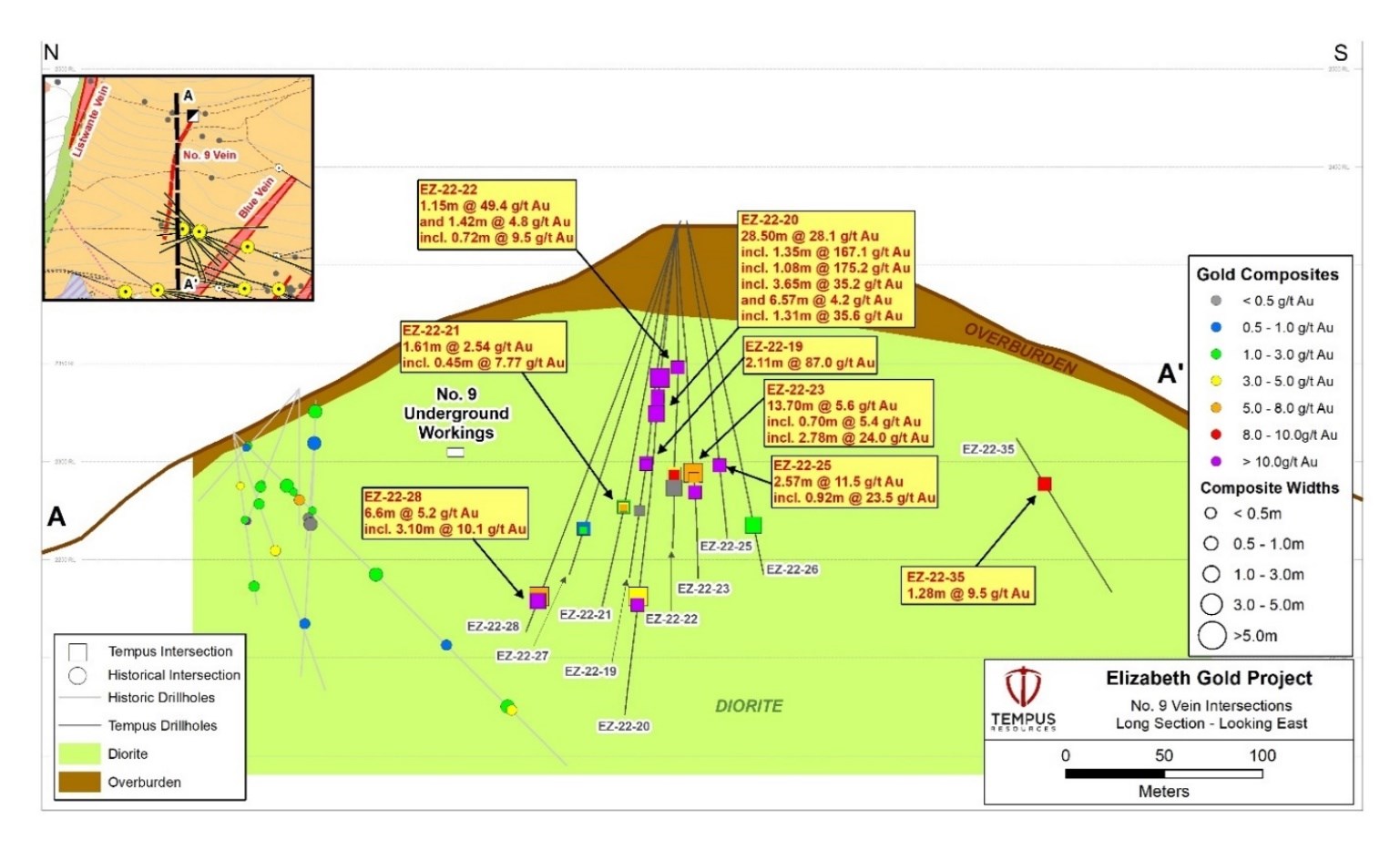
Figure 2 - Elizabeth No. 9 Vein Section View (looking East)
To view an enhanced version of this graphic, please visit:
https://images.newsfilecorp.com/files/7585/155386_cfd27485c49c69ae_002full.jpg
Blue Vein Assay Results
Drill-holes EZ-22-34, EZ-22-35 and EZ-22-36 (released today) extend the high-grade mineralisation zone within the Blue Vein to over 285 metres (See Figure 3). The drill-holes intersected multiple zones of bonanza and high-grade gold mineralisation including EZ-22-35 with 3.9g/t gold over 1.57 metres from 194.32m (including a sub-section of 35.2g/t gold over 0.17 metres) and EZ-22-36 with 24.0g/t gold over 0.25 metres. See Figure 3.

Figure 3 - Blue Vein Section View (Looking Northwest)
To view an enhanced version of this graphic, please visit:
https://images.newsfilecorp.com/files/7585/155386_cfd27485c49c69ae_003full.jpg
West Hanging Wall Vein - A Potential New Vein Set
Drill-hole EZ-22-24 intersected a potential new vein set located approximately 120 metres east of the SW Vein approximately midpoint between the SW Vein and the West Vein. Assays for drill-hole EZ-22-24 included 14.3g/t gold over 1.10 metres from 82.90 metres. See Figure 4.
Further delineation of the West Hanging Wall Vein will be targeted in the Elizabeth 2023 drill program.

Figure 4 - Elizabeth Veins Cross Section (showing West Hanging Wall Vein Location)
To view an enhanced version of this graphic, please visit:
https://images.newsfilecorp.com/files/7585/155386_cfd27485c49c69ae_004full.jpg
This announcement has been authorised by the Board of Directors of Tempus Resources Limited.
Competent Persons Statement
Information in this report relating to Exploration Results is based on information reviewed by Mr. Sonny Bernales, who is a Member of the Engineers and Geoscientists British Columbia (EGBC), which is a recognised Professional Organisation (RPO), and an employee of Tempus Resources. Mr. Bernales has sufficient experience which is relevant to the style of mineralisation and type of deposit under consideration and to the activity which he is undertaking to qualify as a Competent Person as defined by the 2012 Edition of the Australasian Code for reporting of Exploration Results, Mineral Resources and Ore Reserves, and as a Qualified Person for the purposes of NI43-101. Mr. Bernales consents to the inclusion of the data in the form and context in which it appears.
For further information:
TEMPUS RESOURCES LTD
Melanie Ross - Director/Company Secretary Phone: +61 8 6188 8181
About Tempus Resources Ltd
Tempus Resources Ltd ("Tempus") is a growth orientated gold exploration company listed on ASX ("TMR") and TSX.V ("TMRR") and OTCQB ("TMRFF") stock exchanges. Tempus is actively exploring projects located in Canada and Ecuador. The flagship project for Tempus is the Blackdome-Elizabeth Project, a high-grade gold past producing project located in Southern British Columbia. Tempus is currently midway through a drill program at Blackdome-Elizabeth that will form the basis of an updated NI43-101/JORC resource estimate. The second key group of projects for Tempus are the Rio Zarza and Valle del Tigre projects located in south east Ecuador. The Rio Zarza project is located adjacent to Lundin Gold's Fruta del Norte project. The Valle del Tigre project is currently subject to a sampling program to develop anomalies identified through geophysical work.
Forward-Looking Information and Statements
This press release contains certain "forward-looking information" within the meaning of applicable Canadian securities legislation. Such forward-looking information and forward-looking statements are not representative of historical facts or information or current condition, but instead represent only the Company's beliefs regarding future events, plans or objectives, many of which, by their nature, are inherently uncertain and outside of Tempus's control. Generally, such forward-looking information or forward-looking statements can be identified by the use of forward-looking terminology such as "plans", "expects" or "does not expect", "is expected", "budget", "scheduled", "estimates", "forecasts", "intends", "anticipates" or "does not anticipate", or "believes", or variations of such words and phrases or may contain statements that certain actions, events or results "may", "could", "would", "might" or "will be taken", "will continue", "will occur" or "will be achieved". The forward-looking information and forward-looking statements contained herein may include, but are not limited to, the ability of Tempus to successfully achieve business objectives, and expectations for other economic, business, and/or competitive factors. Forward-looking statements and information are subject to various known and unknown risks and uncertainties, many of which are beyond the ability of Tempus to control or predict, that may cause Tempus' actual results, performance or achievements to be materially different from those expressed or implied thereby, and are developed based on assumptions about such risks, uncertainties and other factors set out herein and the other risks and uncertainties disclosed under the heading "Risk and Uncertainties" in the Company's Management's Discussion & Analysis for the quarter ended December 31, 2022 dated February 14, 2023, filed on SEDAR. Should one or more of these risks, uncertainties or other factors materialize, or should assumptions underlying the forward-looking information or statements prove incorrect, actual results may vary materially from those described herein as intended, planned, anticipated, believed, estimated or expected. Although Tempus believes that the assumptions and factors used in preparing, and the expectations contained in, the forward-looking information and statements are reasonable, undue reliance should not be placed on such information and statements, and no assurance or guarantee can be given that such forward-looking information and statements will prove to be accurate, as actual results and future events could differ materially from those anticipated in such information and statements.
The forward-looking information and forward-looking statements contained in this press release are made as of the date of this press release, and Tempus does not undertake to update any forward-looking information and/or forward-looking statements that are contained or referenced herein, except in accordance with applicable securities laws. All subsequent written and oral forward-looking information and statements attributable to Tempus or persons acting on its behalf are expressly qualified in its entirety by this notice.
Neither the ASX Exchange, the TSX Venture Exchange nor its Regulation Service Provider (as that term is defined in the policies of the TSX Venture Exchange) accepts responsibility for the adequacy or accuracy of this release.
Appendix 1
Table 1: Drill Hole Collar Table (2022 Drilling)
| Hole ID | Target | UTM Easting (NAD83Z10) | UTM Northing (NAD83Z10) | Elevation (m) | Length (m) | Azimuth (o) | Dip (o) |
| EZ-22-01 | Blue Vein | 530953 | 5653772 | 2392 | 222.0 | 130 | -65 |
| EZ-22-02 | Blue Vein | 530953 | 5653772 | 2392 | 225.0 | 108 | -65 |
| EZ-22-03 | Blue Vein | 530953 | 5653772 | 2392 | 198.0 | 95 | -50 |
| EZ-22-04 | Blue Vein | 531200 | 5653774 | 2393 | 375.0 | 285 | -55 |
| EZ-22-05 | Blue Vein | 531130 | 5653775 | 2399 | 156.0 | 280 | -45 |
| EZ-22-06 | Blue Vein | 531130 | 5653775 | 2399 | 237.0 | 290 | -55 |
| EZ-22-07 | Blue Vein | 531130 | 5653775 | 2399 | 216.0 | 298 | -45 |
| EZ-22-08 | Blue Vein | 531039 | 5653887 | 2422 | 201.0 | 133 | -50 |
| EZ-22-09 | Blue/SW Vein | 530953 | 5653772 | 2392 | 468.0 | 101 | -53 |
| EZ-22-10 | Blue Vein | 530953 | 5653772 | 2392 | 210.0 | 95 | -65 |
| EZ-22-11 | Blue Vein | 531039 | 5653887 | 2422 | 207.0 | 110 | -60 |
| EZ-22-12 | Blue Vein | 531039 | 5653887 | 2422 | 216.0 | 85 | -50 |
| EZ-22-13 | Blue Vein | 531039 | 5653887 | 2422 | 251.0 | 123 | -65 |
| EZ-22-14 | Blue Vein | 531004 | 5653896 | 2428 | 249.0 | 138 | -65 |
| EZ-22-15 | Blue Vein | 531004 | 5653896 | 2428 | 240.0 | 130 | -65 |
| EZ-22-16 | Blue Vein | 531004 | 5653896 | 2428 | 242.0 | 120 | -65 |
| EZ-22-17 | Blue Vein | 531004 | 5653896 | 2428 | 250.7 | 160 | -65 |
| EZ-22-18 | Blue Vein | 531004 | 5653896 | 2428 | 258.0 | 150 | -65 |
| EZ-22-19 | No.9 Vein | 531041 | 5653893 | 2422 | 201.0 | 284 | -63 |
| EZ-22-20 | No.9 Vein | 531041 | 5653893 | 2422 | 270.0 | 284 | -67 |
| EZ-22-21 | No.9 Vein | 531041 | 5653893 | 2422 | 216.0 | 294 | -63 |
| EZ-22-22 | No.9 Vein | 531041 | 5653893 | 2422 | 183.0 | 274 | -63 |
| EZ-22-23 | No.9 Vein | 531041 | 5653893 | 2422 | 201.0 | 264 | -63 |
| EZ-22-24 | West/Main Veins | 531347 | 5653777 | 2378 | 405.0 | 100 | -45 |
| EZ-22-25 | No.9 Vein | 531039 | 5653888 | 2422 | 181.0 | 254 | -63 |
| EZ-22-26 | No.9 Vein | 531039 | 5653888 | 2422 | 201.0 | 244 | -63 |
| EZ-22-27 | No.9 Vein | 531038 | 5653891 | 2422 | 201.0 | 308 | -63 |
| EZ-22-28 | No.9 Vein | 531038 | 5653891 | 2422 | 234.0 | 318 | -63 |
| EZ-22-29 | SW vein | 531136 | 5653860 | 2422 | 246.0 | 111 | -48 |
| EZ-22-30 | SW vein | 531136 | 5653860 | 2422 | 230.3 | 111 | -55 |
| EZ-22-31 | West/Main Veins | 531351 | 5653773 | 2378 | 444.0 | 110 | -52 |
| EZ-22-32 | West/Main Veins | 531352 | 5653773 | 2378 | 447.0 | 125 | -52 |
| EZ-22-33 | West/Main Veins | 531352 | 5653773 | 2378 | 390.0 | 140 | -52 |
| EZ-22-34 | Blue Vein | 530887 | 5653765 | 2382 | 246.0 | 120 | -55 |
| EZ-22-35 | Blue Vein | 530885 | 5653769 | 2382 | 204.0 | 130 | -45 |
| EZ-22-36 | Blue Vein | 530885 | 5653769 | 2382 | 210.0 | 140 | -47 |
| EZ-22-37 | No.9 Vein | 530888 | 5653769 | 2382 | 201.0 | 290 | -45 |
| EZ-22-38 | Ella Zone | 531917 | 5653591 | 2096 | 102.0 | 80 | -45 |
| EZ-22-39 | Ella Zone | 531917 | 5653591 | 2096 | 156.0 | 110 | -60 |
| EZ-22-40 | Ella Zone | 531917 | 5653591 | 2096 | 170.0 | 140 | -60 |
Table 2: Significant Interval Table (2022 Drilling)
| Hole ID | From (m) | To (m) | Interval (m) | True Thickness (m) | Gold Grade (g/t) | MET ScreenGrade (g/t) | Vein | ||||||
| EZ-22-01 | 123.90 | 124.70 | 0.80 | 0.68 | 2.07 | 2.07 | Blue Vein | ||||||
| and | 125.90 | 126.00 | 0.10 | 0.08 | 3.82 | 3.82 | Blue Vein | ||||||
| and | 161.42 | 161.82 | 0.40 | 0.34 | 2.25 | 2.25 | Blue Vein | ||||||
| EZ-22-02 | 147.65 | 147.83 | 0.18 | 0.15 | 6.88 | 6.88 | Blue Vein | ||||||
| and | 185.25 | 185.85 | 0.60 | 0.51 | 1.89 | 1.89 | Blue Vein | ||||||
| EZ-22-03 | 96.91 | 97.33 | 0.42 | 0.36 | 2.05 | 523 | Blue Vein | ||||||
| and | 124.02 | 124.47 | 0.45 | 0.38 | 32.66 | Not Preformed | Blue Vein | ||||||
| including | 124.02 | 124.13 | 0.11 | 0.09 | 130 | 133 | Blue Vein | ||||||
| and | 164.41 | 166.14 | 1.73 | 1.47 | 7.41 | Not Preformed | Blue Vein | ||||||
| including | 165.41 | 166.14 | 0.73 | 0.62 | 17.4 | Not Preformed | Blue Vein | ||||||
| EZ-22-04 | 353.80 | 354.00 | 0.20 | 0.17 | 1.25 | Not Preformed | Blue Vein | ||||||
| EZ-22-05 | 44.50 | 45.20 | 0.70 | 0.60 | 11.2 | Not Preformed | Blue Vein | ||||||
| and | 56.80 | 57.00 | 0.20 | 0.17 | 1.38 | Not Preformed | Blue Vein | ||||||
| and | 84.65 | 85.55 | 0.90 | 0.77 | 1.33 | Not Preformed | Blue Vein | ||||||
| and | 98.00 | 99.00 | 1.00 | 0.85 | 2.62 | Not Preformed | Blue Vein | ||||||
| EZ-22-06 | 40.20 | 40.90 | 0.70 | 0.60 | 1.91 | Not Preformed | Blue Vein | ||||||
| and | 47.80 | 48.15 | 0.35 | 0.30 | 1.17 | Not Preformed | Blue Vein | ||||||
| and | 153.35 | 155.00 | 1.65 | 1.40 | 1.71 | Not Preformed | Blue Vein | ||||||
| Including | 154.15 | 155.00 | 0.85 | 0.72 | 2.79 | Not Preformed | Blue Vein | ||||||
| EZ-22-07 | 164.6 | 164.92 | 0.32 | 0.27 | 1.45 | Not Preformed | Blue Vein | ||||||
| and | 165.66 | 165.79 | 0.13 | 0.11 | 7.3 | Not Preformed | Blue Vein | ||||||
| and | 170.17 | 170.40 | 0.23 | 0.20 | 48.6 | Not Preformed | Blue Vein | ||||||
| EZ-22-08 | 120.60 | 121.00 | 0.40 | 0.34 | 0.494 | Not Preformed | Blue Vein | ||||||
| EZ-22-09 | 105.12 | 106.17 | 1.05 | 0.89 | 322.54 | 310.72 | Blue Vein | ||||||
| including | 105.12 | 105.32 | 0.20 | 0.17 | 1,654 | 1,572 | Blue Vein | ||||||
| 105.32 | 106.17 | 0.85 | 0.72 | 9.25 | 13.95 | Blue Vein | |||||||
| and | 161.13 | 162.00 | 0.87 | 0.74 | 2.68 | Not Preformed | Blue Vein | ||||||
| and | 356.19 | 358.38 | 2.19 | 1.86 | 0.41 | Not Preformed | SW Vein | ||||||
| Including | 356.19 | 356.70 | 0.51 | 0.43 | 1.05 | Not Preformed | SW Vein | ||||||
| EZ-22-10 | 193.10 | 194.75 | 1.65 | 1.4 | 0.61 | Not Preformed | Blue Vein | ||||||
| Including | 193.98 | 194.23 | 0.25 | 0.21 | 0.997 | Not Preformed | Blue Vein | ||||||
*true thickness is estimated using a multiplier of 0.85. The Company considers anything over 0.2 g/t gold as significant. **no significant intervals
| Hole ID | From (m) | To (m) | Interval (m) | True Thickness (m) | Gold Grade (g/t) | MET Screen Grade (g/t) | Vein | ||||||||||
| EZ-22-11 | 102.85 | 103.15 | 1.40 | 1.19 | 19.91 | Not Preformed | Blue Vein | ||||||||||
| including | 103.15 | 103.45 | 0.30 | 0.26 | 85.2 | Not Preformed | Blue Vein | ||||||||||
| EZ-22-12 | 137.65 | 139.33 | 1.68 | 1.43 | 1.26 | Not Preformed | Blue Vein | ||||||||||
| including | 138.80 | 139.33 | 0.53 | 0.45 | 2.08 | Not Preformed | Blue Vein | ||||||||||
| EZ-22-13 | 108.52 | 108.77 | 0.25 | 0.21 | 1.62 | Not Preformed | Blue Vein | ||||||||||
| and | 111.00 | 111.27 | 0.27 | 0.23 | 1.03 | Not Preformed | Blue Vein | ||||||||||
| and | 112.34 | 112.45 | 0.11 | 0.09 | 15.3 | Not Preformed | Blue Vein | ||||||||||
| and | 196.42 | 196.60 | 0.18 | 0.15 | 1.49 | Not Preformed | Blue Vein | ||||||||||
| and | 215.83 | 216.00 | 0.17 | 0.14 | 1.95 | Not Preformed | Blue Vein | ||||||||||
| EZ-22-14 | 94.40 | 94.60 | 0.20 | 0.16 | 3.23 | Not Preformed | Blue Vein | ||||||||||
| and | 156.28 | 156.51 | 0.23 | 0.18 | 1.08 | Not Preformed | Blue Vein | ||||||||||
| and | 182.66 | 182.82 | 0.16 | 0.13 | 1.6 | Not Preformed | Blue Vein | ||||||||||
| EZ-22-15 | 128.11 | 129.18 | 1.07 | 0.86 | 0.21 | Partially done | Blue Vein | ||||||||||
| and | 146.00 | 146.57 | 0.57 | 0.46 | 0.89 | Not Preformed | Blue Vein | ||||||||||
| including | 146.00 | 146.29 | 0.29 | 0.23 | 1.39 | Not Preformed | Blue Vein | ||||||||||
| and | 186.30 | 186.85 | 0.55 | 0.44 | 1.35 | Not Preformed | Blue Vein | ||||||||||
| and | 224.55 | 224.78 | 0.23 | 0.18 | 1.93 | Not Preformed | Blue Vein | ||||||||||
| EZ-22-16 | 197.10 | 197.68 | 0.58 | 0.46 | 1.96 | Not Preformed | Blue Vein | ||||||||||
| and | 223.2 | 224.45 | 1.25 | 1.00 | 0.76 | Not Preformed | Blue Vein | ||||||||||
| including | 223.42 | 223.7 | 0.28 | 0.22 | 1.58 | Not Preformed | Blue Vein | ||||||||||
| EZ-22-17 | 96.20 | 97.27 | 1.07 | 0.00 | 0.44 | Not Preformed | Blue Vein | ||||||||||
| and | 149.88 | 150.25 | 0.37 | 31.45 | 33.22 | Not Preformed | Blue Vein | ||||||||||
| including | 149.88 | 150.10 | 0.22 | 18.70 | 55.5 | Not Preformed | Blue Vein | ||||||||||
| and | 156.90 | 157.55 | 0.65 | 55.25 | 1.75 | Not Preformed | Blue Vein | ||||||||||
| and | 160.80 | 161.42 | 0.62 | 52.70 | 0.46 | Not Preformed | Blue Vein | ||||||||||
| and | 174.00 | 174.25 | 0.25 | 21.25 | 4.41 | Not Preformed | Blue Vein | ||||||||||
| EZ-22-18 | 142.95 | 143.95 | 1.00 | 85.00 | 47.56 | Not Preformed | Blue Vein | ||||||||||
| including | 143.35 | 143.95 | 0.60 | 51.00 | 79.1 | Not Preformed | Blue Vein | ||||||||||
| and | 149.36 | 150.2 | 0.84 | 71.40 | 0.72 | Not Preformed | Blue Vein | ||||||||||
| including | 149.36 | 149.64 | 0.28 | 23.80 | 1.49 | Not Preformed | Blue Vein | ||||||||||
*true thickness is estimated using a multiplier of 0.85. The Company considers anything over 0.2 g/t gold as significant. **no significant intervals. No. 9 Vein true width cannot be estimated without further drilling
| Hole ID | From (m) | To (m) | Interval (m) | True Thickness (m) | Gold Grade (g/t) | MET Screen Grade (g/t) | Vein | ||||||||||
| EZ-22-19 | 135.67 | 137.78 | 2.11 | 1.69 | 71.09 | 86.99 | No.9 Vein | ||||||||||
| including | 136.11 | 137.49 | 1.38 | 1.10 | 108.56 | 132.82 | No.9 Vein | ||||||||||
| including | 136.79 | 137.49 | 0.70 | 0.56 | 148.03 | 184.9 | No.9 Vein | ||||||||||
| and | 162.92 | 163.68 | 0.76 | 0.61 | 0.48 | Not Preformed | No.9 Vein | ||||||||||
| EZ-22-20 | 85.40 | 113.00 | 28.5 | n/a | 28.15 | 28.13 | No.9 Vein | ||||||||||
| including | 94.65 | 96.00 | 1.35 | n/a | 158.11 | 167.06 | No.9 Vein | ||||||||||
| including | 97.00 | 98.08 | 1.08 | n/a | 181.82 | 175.21 | No.9 Vein | ||||||||||
| including | 104.35 | 108.00 | 3.65 | n/a | 34.96 | 35.24 | No.9 Vein | ||||||||||
| and | 205.00 | 211.75 | 6.75 | n/a | 11.19 | 4.18 | No.9 Vein | ||||||||||
| including | 209.55 | 210.86 | 1.31 | n/a | 54.73 | 35.62 | No.9 Vein | ||||||||||
| EZ-22-21 | 159.76 | 161.37 | 1.61 | n/a | 3.01 | 2.54 | No.9 Vein | ||||||||||
| including | 159.91 | 160.9 | 0.99 | n/a | 4.75 | 3.97 | No.9 Vein | ||||||||||
| or | 160.45 | 160.9 | 0.45 | n/a | 9.75 | 7.77 | No.9 Vein | ||||||||||
| EZ-22-22 | 80.85 | 82.00 | 1.15 | n/a | 49.41 | Not Preformed | No.9 Vein | ||||||||||
| and | 141.00 | 142.42 | 1.42 | n/a | 4.84 | Not Preformed | No.9 Vein | ||||||||||
| including | 141.70 | 142.42 | 0.72 | n/a | 9.54 | Not Preformed | No.9 Vein | ||||||||||
| and | 149.00 | 152.89 | 3.89 | n/a | 0.44 | 0.46 | No.9 Vein | ||||||||||
| EZ-22-23 | 141.10 | 154.80 | 13.70 | n/a | 6.37 | 5.55 | No.9 Vein | ||||||||||
| including | 144.00 | 144.70 | 0.70 | n/a | 4.31 | 5.40 | No.9 Vein | ||||||||||
| including | 152.02 | 154.80 | 2.78 | n/a | 28.39 | 23.97 | No.9 Vein | ||||||||||
| EZ-22-24 | 82.9 | 84 | 1.10 | 0.93 | 14.30 | Not Preformed | West Vein (HW) | ||||||||||
| and | 89.62 | 89.86 | 0.24 | 0.2 | 1.42 | Not Preformed | West Vein (HW) | ||||||||||
| EZ22-25 | 139.10 | 141.67 | 2.57 | n/a | 11.49 | Not Preformed | No.9 Vein | ||||||||||
| including | 139.10 | 140.02 | 0.92 | n/a | 23.54 | Not Preformed | No.9 Vein | ||||||||||
| EZ-22-26 | 173.09 | 176.88 | 3.79 | n/a | 1.03 | 1.40 | No.9 Vein | ||||||||||
| EZ22-27 | 175.00 | 176.50 | 1.50 | n/a | 0.82 | 0.79 | No.9 Vein | ||||||||||
| including | 176.00 | 176.50 | 0.50 | n/a | 1.13 | 1.00 | No.9 Vein | ||||||||||
| EZ-22-28 | 214.10 | 220.70 | 6.60 | n/a | 6.10 | 5.16 | No.9 Vein | ||||||||||
| including | 216.75 | 219.85 | 3.10 | n/a | 12.10 | 10.11 | No.9 Vein | ||||||||||
| or | 216.75 | 218.38 | 1.63 | n/a | 21.46 | 34.98 | No.9 Vein | ||||||||||
*true thickness is estimated using a multiplier of 0.85. The Company considers anything over 0.2 g/t gold as significant. **no significant intervals. No. 9 Vein true width cannot be estimated without further drilling
| Hole ID | From (m) | To (m) | Interval (m) | True Thickness (m) | Gold Grade (g/t) | MET Screen Grade (g/t) | Vein | ||||||||||
| EZ-22-29 | 212.75 | 214.7 | 1.95 | 1.66 | 2.3 | 2.21 | SW Vein | ||||||||||
| and | 213.65 | 214.7 | 1.05 | 1.06 | 3.27 | 3.62 | SW Vein | ||||||||||
| EZ22-30 | 227.21 | 230.25 | 3.04 | 2.43 | 2.58 | Not Preformed | SW Vein | ||||||||||
| including | 229.15 | 230.25 | 1.10 | 0.88 | 6.74 | Not Preformed | SW Vein | ||||||||||
| EZ22-31 | 254.38 | 256.36 | 1.98 | 1.58 | 1.50 | 1.49 | West/Main Vein | ||||||||||
| including | 254.70 | 255.85 | 1.15 | 0.92 | 2.12 | 2.13 | West/Main Vein | ||||||||||
| and | 434.61 | 436.25 | 1.64 | 1.31 | 0.57 | 0.58 | West/Main Vein | ||||||||||
| EZ-22-32 | 96.90 | 97.52 | 0.62 | 0.53 | 2.64 | Not Preformed | West Vein | ||||||||||
| and | 138.40 | 139.03 | 0.63 | 0.54 | 2.03 | Not Preformed | West Vein | ||||||||||
| and | 186.00 | 186.55 | 0.55 | 0.47 | 0.73 | Not Preformed | West Vein | ||||||||||
| and | 386.56 | 388.67 | 2.11 | 1.79 | 0.81 | Not Preformed | Main Vein | ||||||||||
| including | 387.56 | 388.67 | 1.11 | 0.94 | 1.39 | Not Preformed | Main Vein | ||||||||||
| EZ22-33 | 158.80 | 161.00 | 2.20 | 1.87 | 1.82 | Not Preformed | West/Main Vein | ||||||||||
| including | 158.80 | 160.00 | 1.20 | 1.02 | 2.60 | Not Preformed | West/Main Vein | ||||||||||
| and | 377.00 | 378.18 | 1.18 | 1.00 | 5.69 | 4.33 | West/Main Vein | ||||||||||
| including | 377.67 | 378.18 | 0.51 | 0.43 | 13.00 | 9.85 | West/Main Vein | ||||||||||
| EZ-22-34 | 138.50 | 141.35 | 2.85 | 2.51 | 0.29 | 0.29 | Blue Vein | ||||||||||
| and | 192.74 | 1.93 | 0.26 | 0.22 | 1.03 | Not Preformed | Blue Vein | ||||||||||
| EZ-22-35 | 129.18 | 130.46 | 1.28 | 1.09 | 9.19 | 9.46 | No.9/Blue Vein | ||||||||||
| and | 194.32 | 195.89 | 1.57 | 1.33 | 2.82 | 3.90 | No.9/Blue Vein | ||||||||||
| including | 194.32 | 194.49 | 0.17 | 0.14 | 25.20 | 35.15 | No.9/Blue Vein | ||||||||||
| EZ-22-36 | 141.58 | 142.75 | 1.17 | 0.99 | 0.67 | 0.45 | No.9/Blue Vein | ||||||||||
| and | 188.38 | 188.63 | 0.25 | 0.21 | 19.80 | 23.96 | No.9/Blue Vein | ||||||||||
| EZ22-37 | 182.38 | 182.90 | 0.52 | n/a | 0.83 | Not Preformed | No.9 Vein | ||||||||||
| EZ22-38 | 49.45 | 50.87 | 1.42 | 1.21 | 0.76 | Not Preformed | Ella Zone | ||||||||||
| including | 49.81 | 50.30 | 0.49 | 0.42 | 1.41 | Not Preformed | Ella Zone | ||||||||||
| EZ22-39 | 109.19 | 110.60 | 1.41 | 1.20 | 1.68 | Not Preformed | Ella Zone | ||||||||||
| including | 109.19 | 109.85 | 0.66 | 0.56 | 2.93 | Not Preformed | Ella Zone | ||||||||||
| EZ22-40 | 138.84 | 139.80 | 0.96 | 0.87 | 1.04 | Not Preformed | Ella Zone | ||||||||||
*true thickness is estimated using a multiplier of 0.85. The Company considers anything over 0.2 g/t gold as significant. **no significant intervals No. 9 Vein true width cannot be estimated without further drilling
Appendix 2: The following tables are provided to ensure compliance with the JORC Code (2012) requirements for the reporting of Exploration Results for the Elizabeth - Blackdome Gold Project
Section 1: Sampling Techniques and Data
(Criteria in this section apply to all succeeding sections.)
| Criteria | JORC Code explanation | Commentary | |
| Sampling techniques |
|
| |
| Drilling techniques |
|
| |
| Drill sample recovery |
|
| |
| Logging |
|
| |
| Sub- sampling techniques and sample preparation |
|
| |
| Quality of assay data and laboratory tests |
|
| |
| Verification of sampling and assaying |
|
| |
| Location of data points |
|
| |
| Data spacing and distribution |
|
| |
| Orientation of data in relation to geological structure |
|
| |
| Samples Security |
|
| |
| Audits or Reviews |
|
| |
Section 2: Reporting of Exploration Results
(Criteria listed in the preceding section also apply to this section.)
| Criteria | JORC Code explanation | Commentary | |
| Mineral tenement and land tenure status |
|
| |
| Exploration done by other parties |
|
| |
| Geology |
|
| |
| Drill hole Information |
|
| |
| Data aggregation methods |
|
| |
| Relationship between mineralisation widths and intercept lengths |
|
| |
| Diagrams |
|
| |
| Balanced reporting |
|
| |
| Other substantive exploration data |
|
| |
| Further work |
|
| |
![]()
To view the source version of this press release, please visit https://www.newsfilecorp.com/release/155386
Source: Tempus Resources Limited