Toronto, Ontario--(Newsfile Corp. - October 17, 2022) - Aurania Resources Ltd. (TSXV: ARU) (OTCQB: AUIAF) (FSE: 20Q) ("Aurania" or the "Company") is pleased to announce that positive findings of careful relogging of drill core together with the integration of geophysics and geochemistry from its Tiria-Shimpia target in Aurania's Lost Cities-Cutucu project in southeastern Ecuador (the "Project"), has revealed the presence of a chain of three structural grabens occupying the middle of the concession block. Grabens are extremely important in mineral exploration because their bounding faults are often through-going conduits for hydrothermal fluids, and they have very high potential to be mineralized. This underlying work is integral to advancing ongoing joint venture discussions while the Company begins preparations for a drill program at its Tatasham and Awacha porphyry targets expected to commence later in 2022. Both programs remain in line with Aurania's corporate strategy discussed in February 2022.
Professor Gregor Borg, a recognized international expert on sediment-hosted copper deposits commented on the review/reinterpretation of Aurania's geological data, "The reassembly and reinterpretation of available data makes a totally new and very exciting story!"
The north graben is 10 kilometres long and 3.5 kilometres wide, the central graben is 26 kilometres long and 3 kilometres wide; and the south graben is 18 kilometres long and 5 kilometres wide.
Structural grabens, also known as pull-aparts or drop-downs, are areas where younger rocks have been faulted downwards vertically, between older rocks by opposing horizontal forces. It can be thought of as if the rocks have been stretched horizontally in opposite directions to breaking point, and then have subsided downward along vertical bounding cracks (faults). Grabens can be recognized in the field when the rocks abruptly appear out of age sequence. Lundin Gold's Fruta del Norte gold deposit, approximately 100 kilometres south of the Project, lies in a structural graben as does Aurania board member Thomas Ullrich's recent high-grade copper discovery at the Storm deposit of Aston Bay in northern Canada. A number of mineralizing patterns have now come into focus, which will be explained below, and Management considers that the prospectivity of its sediment-hosted targets within the Project has been very considerably enhanced. The process of review by Aurania's technical team and consultants is ongoing.
Dr. Cristian Vallejo, Aurania's Consultant Geological Expert on the Cutucu area, has relogged the Tiria-Shimpia and Tsenken drillcore, placing it in the correct geological context. It was found that a contracted paleontologist had incorrectly dated several index fossils and that Tiria-Shimpia sits in rocks that are 90 million years younger than previously believed. Dr. Vallejo convincingly correlated the drilling with oil well DRA-29 outside the Project, and also dissolved representative pieces of Tiria-Shimpia core in acid for palynology (dating of fossil pollen). The results definitively place the four Tiria-Shimpia holes in the Hollin and Napo Formations, which are understood to the primary reservoir rocks for oil in Ecuador. In fact, impregnations of petroleum were found at depths of 345.8 metres ("m") to 357 m in Hole #2 in Shimpia. While Management of Aurania does not consider there to be any potential for economic petroleum in the concessions, the importance of this finding in the context of sediment-hosted base metal deposits cannot be overemphasized. Crude petroleum, bitumen and natural gas have all been implicated as precipitation agents in the formation of sediment-hosted copper deposits, and lead-zinc-silver deposits. The two styles of mineralization are sometimes found in proximity but are separated horizontally or vertically due to precipitation kinetics.
Over the last several years, Aurania has located numerous high-grade copper/silver showings across the Project (see press releases dated August 6, 2020, July 30, 2020, April 9, 2019, April 2, 2019, and October 4, 2018), but the proper understanding of the ore-deposits framework still eluded us to some extent. We now know that the lower part of much of the concession area is occupied by Jurassic-aged Chapiza redbed sediments that contain salt and that are over a kilometre in thickness. To date, salt has been intersected in three drill holes in Tsenken and anhydrite evaporites were found in two other holes. The copper/silver mineralization sits within laterally impersistent and thin beds of carbonaceous trash in the upper Chapiza, stratigraphically above the salt beds, where plant debris and other organics have acted as chemical reductants, precipitating copper and silver from circulating saline brine. The scenario is not unlike the Kupferschiefer of eastern Germany and Poland, but by themselves our thin beds are volumetrically too minor to represent orebodies and are not exploration targets.
One exploration target however does leap out as exceptional and will be discussed presently. The Chapiza redbeds would equate with the Rotliegendes (in German, the "underlying red") directly beneath the Kupferschiefer, an organic-rich "copper shale" which hosts the economic orebodies in Poland. We believed formerly that our carbonaceous beds were a direct analogue to the Kupferschiefer unit, and indeed in some ways they are, but a much better exploration target is proffered by the Hollin Formation higher in stratigraphy, which is both thick and bituminous with good porosity. These rocks were formerly not thought to be in the central graben, but the recent study made by Cristian Vallejo has identified the Upper Hollin formation ("Fm") in hole #1 and #2 below the Napo Fm. Hollin also subcrops within the southern graben, in an area where there is a large MobileMT ("MMT") conductive anomaly that was heretofore considered to be spurious.
The geological model for sediment-hosted copper deposits is predicated on a source accumulation of oxidized sediments in a basin that has occasionally evaporated to dryness, leaving behind salt beds. The theory is that minute amounts of copper in oxidized minerals become labile and can be stripped and then mobilized in brine as copper chloride. Heated brine would typically travel upwards through the rock column along faults and where it encountered organics, pyrite, or some other precipitation agent would drop the copper out of solution to form copper sulphides such as chalcocite. Professor Borg has previously commented that the presence of coeval porphyry copper deposits in the Chapiza means that the basin is "Turbocharged" with a "Double whammy", or twice as much fertile copper potential as a normal scenario. Watch the video with Prof. Borg here: http://www.aurania.com/the-opportunity-a-copper-experts-opinion. The same model components are present in the Kupferschiefer and Aston Bay's new Storm deposit but without copper porphyry.

Figure 1: From Vallejo et al. 2021. The central panel pertains to the Cutucu and provides stratigraphic context to this press release. The host rocks to Zn-Pb-Ag at Tiria-Shimpia are in the middle Napo Shale of the central panel. Previously they were believed to be in the Santiago Fm, at the very bottom of the stratigraphic column in the lower Jurassic. The copper source rocks and salt are in the Late Jurassic Chapiza Fm.
To view an enhanced version of Figure 1, please visit:
https://images.newsfilecorp.com/files/2477/140759_836386a1349a89b6_001full.jpg

Figure 2: Interpreted geology. The sense of throw on the faults is still to be entirely defined. Most of the field of view is occupied by the NNW Central Graben containing Napo and Hollin Fm. The Southern Graben contains Napo, Hollin and Chapiza in a synclinal structure.
To view an enhanced version of Figure 2, please visit:
https://images.newsfilecorp.com/files/2477/140759_836386a1349a89b6_002full.jpg

Figure 3: The magnetic airborne survey reduced to pole, first vertical derivative. The Central Graben is in the centre of view and silver occurrences are along the boundary faults as well as internal longitudinal faults. A second cluster of silver values is in the Southern Graben block and are related to a different style of mineralization (Cu-Ag).
To view an enhanced version of Figure 3, please visit:
https://images.newsfilecorp.com/files/2477/140759_836386a1349a89b6_003full.jpg
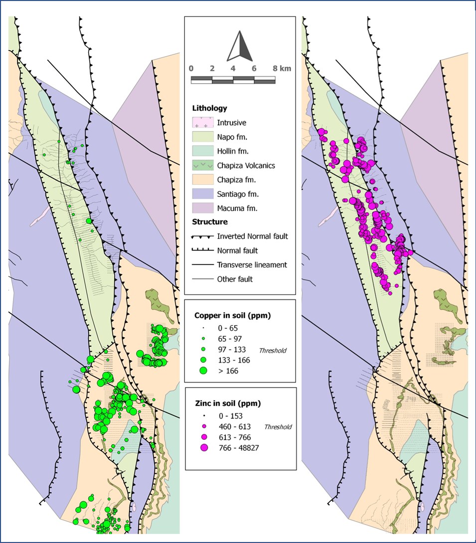
Figure 4: The distribution of copper and zinc in soils, within surveyed and sampled areas. Note that the distribution of Zn in the Central Graben mimics the distribution of Ag in outcrop from Figure 3. Cu has a wider distribution and is concentrated in Tsenken in the Southern Graben where it occurs close to copper-in-sediment occurrences but is also anomalous in other areas. These other areas are flows and subvolcanic intrusives of basalt to andesite within the Chapiza Fm. Drilling has shown them to be partially to completely oxidized, and coeval with the redbed sediments. They have high intrinsic backgrounds in Cu and Co and are considered an excellent protolith for mobilization into stratigraphically higher sediments.
To view an enhanced version of Figure 4, please visit:
https://images.newsfilecorp.com/files/2477/140759_836386a1349a89b6_004full.jpg

Figure 5: Soil results for uranium.
To view an enhanced version of Figure 5, please visit:
https://images.newsfilecorp.com/files/2477/140759_836386a1349a89b6_005full.jpg

Figure 6: Soil results for chromium.
To view an enhanced version of Figure 6, please visit:
https://images.newsfilecorp.com/files/2477/140759_836386a1349a89b6_006full.jpg
Figures 5 and 6 are blow ups of the South Graben area. Figure 5 has the distribution of uranium in soils superimposed and 6, chromium in soils superimposed. The folded calc-alkaline basalt and andesite flow is outlined by Cr contents in Figure 6 (due to mafic character) and is clearly seen in Figure 5, which is free of anomalous U values over the flow. The saddle-shaped folding of the flow is clearly duplicated up-section by anomalous uranium, highly suggesting there is a stratiform accumulation of uranium in sediments. The picture for copper in Figure 4 is less clear but potentially covariant with uranium. Copper and uranium are often found together in sediment-hosted deposits e.g., Zambia Copperbelt. There is no MMT conductor in this area and potentially the sediments are shallow enough that sulphide has been weathered to carbonates and oxides. This is considered a very good drill target for the future.

Figure 7: MMT image over the Tsenken target area (South Graben). The hot colours are the conductors. Note that the salt occurrences along the graben boundary faults are extremely strong conductors. Salt itself is an insulator but with addition of water becomes strongly conductive. The brine springs used by the Shuar to produce salt are in the same area The circa 3 x 5 km conductivity anomaly on the west side of Tsenken remains unexplained and undrilled. Because it has depth extent it is thought to be a porphyry body which is buried within the Chapiza. It is a high priority target. The labelled conductor "copper target" mimics the saddle shape of the syncline lower in stratigraphy, and is composed of lower Hollin Fm. This is a 3.5 x 3 km target and appears to be stratiform and potentially stratabound. It is considered the highest priority copper-in-sediment target in this new interpretation.
To view an enhanced version of Figure 7, please visit:
https://images.newsfilecorp.com/files/2477/140759_836386a1349a89b6_007full.jpg

Figure 8: A stratigraphic column modified from Vallejo, 2022. It shows diagrammatically the presence of organic carbon plotted against the stratigraphy of the rocks in the Cutucu. As can be seen, the layers with carbon in the Chapiza Fm are quite thin. Near the bottom of the Hollin Fm the carbon level picks up dramatically. As a working hypothesis we believe that some mobilized copper is deposited by fluids when they encounter carbonaceous layers in the Chapiza Fm, and we see abundant evidence of that in outcrop. We believe though that the majority of the copper will continue to migrate up-section until it comes in contact with the major carbon bearing units of the lower Hollin Fm. These units do not outcrop and Tiria-Shimpia hole #2 was too shallow to test this hypothesis. After dumping the copper, the fluids continued to move up-section into the Napo Fm where they deposited the zinc-lead-silver. MMT coverage over the Tiria-Shimpia area is limited, but deep conductors along the boundary faults and below the zinc-lead-silver if found, would reinforce this hypothesis.
To view an enhanced version of Figure 8, please visit:
https://images.newsfilecorp.com/files/2477/140759_836386a1349a89b6_008full.jpg
Unusually, there is enough potassium (potash) component in the salt to both make it deep orange in colour, and mildly radioactive. Fault traces where salt is present are both radiometric K-channel anomalies and strong conductors. The zinc-lead-silver mineralization at Tiria-Shimpia also shows up as K-channel radiometric anomalies, and this is potentially due to the presence of large amounts of celestite, a strontium mineral that can contain moderate amounts of potassium. There are a large number of these radiometric targets along boundary faults that do not outcrop and have yet to be drilled. The integration of radiometric, magnetometer and magneto-telluric surveys is not fully completed and will with high probability yield more targets.
Qualified Person
The geological information contained in this news release has been verified and approved by Jean-Paul Pallier, MSc, VP Exploration. Mr. Pallier is a designated EurGeol by the European Federation of Geologists and a Qualified Person as defined by National Instrument 43-101, Standards of Disclosure for Mineral Projects of the Canadian Securities Administrators.
About Aurania
Aurania is a mineral exploration company engaged in the identification, evaluation, acquisition and exploration of mineral property interests, with a focus on precious metals and copper in South America. Its flagship asset, The Lost Cities - Cutucu Project, is located in the Jurassic Metallogenic Belt in the eastern foothills of the Andes mountain range of southeastern Ecuador.
Information on Aurania and technical reports are available at www.aurania.com and www.sedar.com, as well as on Facebook at https://www.facebook.com/auranialtd/, Twitter at https://twitter.com/auranialtd, and LinkedIn at https://www.linkedin.com/company/aurania-resources-ltd-.
For further information, please contact:
Carolyn Muir
VP Corporate Development & Investor Relations
Aurania Resources Ltd.
(416) 367-3200
carolyn.muir@aurania.com
Neither the TSX Venture Exchange nor its Regulation Services Provider (as that term is defined in the policies of the TSX Venture Exchange) accepts responsibility for the adequacy or accuracy of this release.
Forward-Looking Statements
This news release may contain forward-looking information that involves substantial known and unknown risks and uncertainties, most of which are beyond the control of Aurania. Forward-looking statements include estimates and statements that describe Aurania's future plans, objectives or goals, including words to the effect that Aurania or its management expects a stated condition or result to occur. Forward-looking statements may be identified by such terms as "believes", "anticipates", "expects", "estimates", "may", "could", "would", "will", or "plan". Since forward-looking statements are based on assumptions and address future events and conditions, by their very nature they involve inherent risks and uncertainties. Although these statements are based on information currently available to Aurania, Aurania provides no assurance that actual results will meet management's expectations. Risks, uncertainties and other factors involved with forward-looking information could cause actual events, results, performance, prospects and opportunities to differ materially from those expressed or implied by such forward-looking information. Forward looking information in this news release includes, but is not limited to Aurania's objectives, goals or future plans, statements, exploration results, potential mineralization, the corporation's portfolio, treasury, management team and enhanced capital markets profile, the estimation of mineral resources, exploration, timing of the commencement of operations and estimates of market conditions. Factors that could cause actual results to differ materially from such forward-looking information include, but are not limited to, failure to identify mineral resources, failure to convert estimated mineral resources to reserves, the inability to complete a feasibility study which recommends a production decision, the preliminary nature of metallurgical test results, delays in obtaining or failures to obtain required governmental, regulatory, environmental or other project approvals, political risks, inability to fulfill the duty to accommodate indigenous peoples, uncertainties relating to the availability and costs of financing needed in the future, changes in equity markets, inflation, changes in exchange rates, fluctuations in commodity prices, delays in the development of projects, capital and operating costs varying significantly from estimates and the other risks involved in the mineral exploration and development industry, the effects of COVID-19 on the business of the Company including but not limited to the effects of COVID-19 on the price of commodities, capital market conditions, restrictions on labour and international travel and supply chains, and those risks set out in Aurania's public documents filed on SEDAR. Although Aurania believes that the assumptions and factors used in preparing the forward-looking information in this news release are reasonable, undue reliance should not be placed on such information, which only applies as of the date of this news release, and no assurance can be given that such events will occur in the disclosed time frames or at all. Aurania disclaims any intention or obligation to update or revise any forward-looking information, whether as a result of new information, future events or otherwise, other than as required by law.
To view the source version of this press release, please visit https://www.newsfilecorp.com/release/140759
Source: Aurania Resources Ltd.