Controlling Structure and Graphitic Package Defined on New Discovery
Multiple Intersections of Elevated Radioactivity Below Unconformity
Preliminary Planned $10 Million 2023 Program Submitted to Joint Venture
Vancouver, British Columbia--(Newsfile Corp. - September 29, 2022) - CanAlaska Uranium Ltd. (TSXV: CVV) (OTCQX: CVVUF) (FSE: DH7N) ("CanAlaska or the "Company") is pleased to announce successful completion of the $5 million 2022 drilling program at the West McArthur project. The majority of this program was focused on expansion of the newly announced high-grade basement-hosted uranium discovery on the project.
The Company is pleased to report three additional drillholes with elevated radioactivity, highlighted by a 12.4 metre (40.7 feet) intersection that contains multiple metre to sub-metre scale intervals of elevated radioactivity in WMA072-3, the last hole of the program. Geochemical assay results from the summer drill program, outside of the previously reported high-grade intersection of 2.4% U3O8 over 9.0 metres from 906.5 metres in WMA067, are pending. The West McArthur project is operated by CanAlaska, which currently holds a 78.91% ownership in the project.
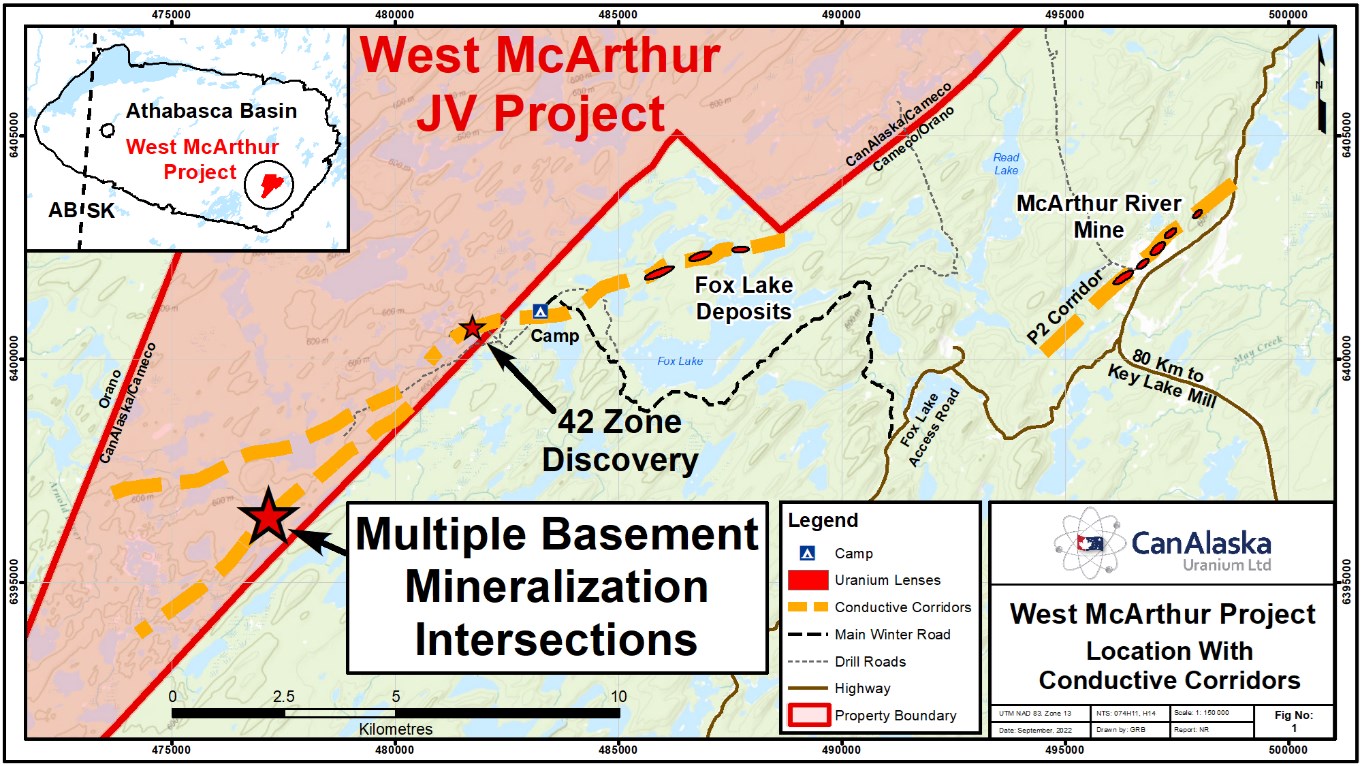
Figure 1 – West McArthur Property Location Map
To view an enhanced version of Figure 1, please visit:
https://images.newsfilecorp.com/files/2864/138799_ef7a14d774da1b84_002full.jpg
The drilling program consisted of 10,632 metres over 11 completed drill target tests. The initial program was focused on continued expansion of the 42 Zone mineralization and the immediate 1.8 kilometre anomalous trend to the southwest, in addition to regional testing of the newly acquired geophysical data. After the discovery of high-grade basement-hosted uranium mineralization in WMA067, on the second regional test of the drill program (see press release dated July 15th, 2022), the Company focused its efforts on understanding the controls of the mineralization. WMA067 is located 6 kilometres along strike to the southwest of the Company's 42 Zone mineralization on the C10 South conductive corridor. As part of the discovery follow-up, eight drill tests were completed on the same fence or immediately along strike of the WMA067 discovery hole. Elevated radioactivity was intersected in drillholes WMA067-4, WMA070, and WMA072-3 (Figure 2).

Figure 2 – Drill Hole Locations from WMA067 Discovery Area
To view an enhanced version of Figure 2, please visit:
https://images.newsfilecorp.com/files/2864/138799_ef7a14d774da1b84_004full.jpg
Next Steps
The Company believes that it has successfully identified the orientation of the controlling structure for the basement-hosted uranium mineralization. The ideal target, where this controlling-structure intersects the unconformity, has not been tested and remains a high-priority target for the next drilling program. A preliminary planned budget has been submitted to the Joint Venture for a $10 million 2023 exploration program scheduled to commence in January.
Drillhole Details
WMA072-3 tested 38 metres up-dip towards the northeast of WMA067 along the graphitic pelite. The basement consists of a wide package of graphitic and non-graphitic pelitic metasediments overprinted by clay and chlorite alteration. Multiple fault zones consisting of clay gouge, broken core, and cataclastic breccias were intersected in the basement of WMA072-3. The drill hole intersected a 12.4 metre long intersection that contains multiple metre to sub-metre scale intervals of elevated radioactivity (> 300 counts per second (cps) on handheld CT007-M scintillometer). The mineralization is highlighted by a 20 cm interval of massive off-scale pitchblende (> 65,500 cps on handheld CT007-M scintillometer). This is followed by multiple intervals of semi-massive, blebby, vein-controlled, and foliation-controlled pitchblende associated with yellow to orange uranium secondaries that range from 10 to 90 cm in length (shown in red on Figure 3). WMA072-3 is interpreted to have intersected the targeted horizon near the controlling structure, slightly to the east of the ideal target. Core recovery throughout the basement intersection is 100%.

Figure 3 – Drill Core Photographs of WMA072-3
To view an enhanced version of Figure 3, please visit:
https://images.newsfilecorp.com/files/2864/138799_ef7a14d774da1b84_006full.jpg
WMA067-4 tested 30 metres up-dip of WMA067. The basement consists of a wide package of graphitic and non-graphitic pelitic metasediments overprinted by clay, chlorite, and hematite alteration associated with fault zones that contain clay gouge, broken core, and cataclastic breccias. The drill hole intersected two zones of elevated radioactivity between 887.4 and 888.3 metres, consisting of one 60 cm and one 10 cm interval (> 300 cps on handheld CT007-M scintillometer). The mineralization is characterized by semi-massive and vein-controlled pitchblende with weak yellow uranium secondaries. WMA067-4 is interpreted to have intersected the targeted horizon to the west of the main mineralized controlling structure. Core recovery throughout the basement intersection is 100%.
WMA070 tested 80 metres up-dip and to the east of WMA067. The basement consists of a wide package of graphitic and non-graphitic pelitic metasediments overprinted by clay, chlorite, and hematite alteration. Multiple graphitic fault zones characterized by cataclasites, clay gouge, and enhanced alteration were intersected throughout the graphitic pelite sequence. The drill hole intersected a 4.5 metre wide zone that contains multiple sub-metre scale intervals of elevated radioactivity (> 300 cps on handheld CT007-M scintillometer). The mineralization is characterized by vein-controlled and disseminated pitchblende with weak yellow uranium secondaries. WMA070 is interpreted to have intersected the targeted horizon to the east of the main mineralized controlling structure. Core recovery throughout the basement intersection is 100%.
An additional three drill holes were completed on the WMA067 fence. WMA067-1 intersected the targeted horizon 25 metres immediately down-dip of WMA067, WMA067-2 intersected the targeted horizon 30 metres along strike to the east of WMA067, and WMA071 intersected the targeted horizon 60 metres up-dip and to the west to WMA067. All three drill holes intersected variably bleached and chlorite-altered basement. In addition, all three drill holes intersected the targeted graphitic metasedimentary package and re-activated fault structures. The three drillholes that lack significant radioactivity did not intersect the mineralized controlling structure. However, these three drill holes confirm the system is still active in the area, with alteration and structure that are indicative of the mineralizing event and help to define the plunge of the basement-hosted mineralization along the WMA067 fence.
Additionally, WMA073 was completed 160 metres along strike to the northeast of the WMA067 fence, targeting the uppermost contact of the interpreted graphitic package that is host to the WMA067 mineralization. WMA073, drilled at an azimuth of 320˚ with an inclination of -80˚, intersected a 40 metre wide structural zone in the medial sandstone column from 573 m that is characterized by strong bleaching, silicification, and limonite alteration associated with steeply-dipping fractures, clay-healed breccias, and isolated sandy-clay gouge. Several intervals of poor recovery, 10 - 50%, were reported within the core of the structural zone between 587 and 605 metres. The basement of WMA073, below the unconformity at 804.5 metres, consisted of footwall metasediments followed by granitic gneiss. Based on the intense faulting and alteration in the lower sandstone, coupled with the footwall stratigraphy, it is interpreted that WMA073 overshot the target at the unconformity by approximately 60 metres. Based on these results, immediate follow up of the sandstone structure back to the ideal target at the unconformity is warranted.
Table 1 - Significant Radioactive Intervals Summary
| DDH | From (m) | To (m) | Length (m)4 | Interval Radioactivity (cps)1,2,3 | Maximum Radioactivity (cps)1,2,3 | ||||
| WMA067-1 Easting: 477,284 mE Northing: 6,396,396 mN Elevation: 605.8m A.S.L. Azimuth: 325˚ Dip: -75.7˚ | No significant elevated radioactivity intersected | ||||||||
| WMA067-2 Easting: 477,284 mE Northing: 6,396,396 mN Elevation: 605.8m A.S.L. Azimuth: 325˚ Dip: -75.7˚ | No significant elevated radioactivity intersected | ||||||||
| WMA067-4 Easting: 477,284 mE Northing: 6,396,396 mN Elevation: 605.8m A.S.L. Azimuth: 325˚ Dip: -75.7˚ | 887.4 | 888 | 0.6 | > 300 | 12,700 | ||||
| 888.2 | 888.3 | 0.1 | > 300 | 1,700 | |||||
| WMA070 Easting: 477,258 mE Northing: 6,396,517 mN Elevation: 599 m A.S.L. Azimuth: 322˚ Dip: -82.0˚ | 809.1 | 810 | 0.90 | > 300 | 2,900 | ||||
| 810.6 | 811.1 | 0.5 | > 300 | 31,000 | |||||
| 811.9 | 812.3 | 0.4 | > 300 | 1,000 | |||||
| 813 | 813.6 | 0.6 | > 300 | 15,000 | |||||
| WMA071 Easting: 477,257 mE Northing: 6,396,517 mN Elevation: 599 m A.S.L. Azimuth: 300˚ Dip: -80.0˚ | No significant elevated radioactivity intersected | ||||||||
| WMA072-3 Easting: 477,256 mE Northing: 6,396,520 mN Elevation: 599 m A.S.L. Azimuth: 313˚ Dip: -82.0˚ | 846.4 | 847 | 0.6 | > 300 | > 65,500 | ||||
| 847.1 | 848.1 | 1.0 | > 300 | 16,000 | |||||
| 848.3 | 848.6 | 0.3 | > 300 | 475 | |||||
| 850.3 | 850.7 | 0.4 | > 300 | 10,100 | |||||
| 853.9 | 854.7 | 0.8 | > 300 | 13,500 | |||||
| 855.0 | 855.5 | 0.5 | > 300 | 7,200 | |||||
| 855.7 | 856.6 | 0.9 | > 300 | 3,600 | |||||
| 857.9 | 858.6 | 0.7 | > 300 | 12,600 | |||||
| 858.7 | 858.8 | 0.1 | > 300 | 1,100 | |||||
| |||||||||
CanAlaska CEO, Cory Belyk, comments, "The style of alteration and mineralization with local zones of very high-grade uranium mineralization is exactly what we would anticipate from the drilling program in this geological setting. The presence of off-scale radiometric results highlights the potential of this system to deposit large amounts of high-grade uranium. With a better understanding of the controlling fault structures now in hand, the CanAlaska team will focus on testing the target area at the unconformity, along strike and within the basement. This is a growing discovery that is truly wide open and we look forward to the next drilling program that is currently planned for early 2023."
Geochemical Sampling Procedures
All drill core samples from the 2022 summer program have been received by the Saskatchewan Research Council Geoanalytical Laboratories (SRC) in Saskatoon, Saskatchewan. The samples were shipped in secure containment for preparation, processing, and multi-element analysis by ICP-MS and ICP-OES using total (HF:NHO3:HClO4) and partial digestion (HNO3:HCl), boron by fusion, and U3O8 wt% assay by ICP-OES using higher grade standards. Radiometric assay samples are chosen based on downhole probing radiometric equivalent uranium grades and scintillometer (SPP2 or CT007-M) peaks. Assay samples comprise 0.3 - 0.5 metre continuous split-core samples over the mineralized interval. A 0.1% U3O8 cut-off with a maximum internal dilution of 1 metre is used for compositing and reporting the data. The SRC is an ISO/IEC 17025/2005 and Standards Council of Canada certified analytical laboratory. Blanks, standard reference materials, and repeats are inserted into the sample stream at regular intervals by CanAlaska and the SRC in accordance with CanAlaska's quality assurance / quality control (QA/QC) procedures. Geochemical assay data are subject to verification procedures by qualified persons employed by CanAlaska prior to disclosure.
All reported depths and intervals are drill hole depths and intervals, unless otherwise noted, and do not represent true thicknesses, which have yet to be determined.
About CanAlaska Uranium
CanAlaska Uranium Ltd. (TSXV: CVV) (OTCQX: CVVUF) (FSE: DH7N) holds interests in approximately 300,000 hectares (750,000 acres), in Canada's Athabasca Basin - the "Saudi Arabia of Uranium." CanAlaska's strategic holdings have attracted major international mining companies. CanAlaska is currently working with Cameco and Denison at two of the Company's properties in the Eastern Athabasca Basin. CanAlaska is a project generator positioned for discovery success in the world's richest uranium district. The Company also holds properties prospective for nickel, copper, gold and diamonds. For further information visit www.canalaska.com.
The qualified technical person for this news release is Nathan Bridge, MSc., P.Geo., CanAlaska's Vice President, Exploration.
On behalf of the Board of Directors
"Peter Dasler"
Peter Dasler, M.Sc.
President
CanAlaska Uranium Ltd.
Contacts:
Cory Belyk, Executive VP and CEO
Tel: +1.604.688.3211 x 306
Email: cbelyk@canalaska.com
Peter Dasler, President
Tel: +1.604.688.3211 x 138
Email: info@canalaska.com
Neither TSX Venture Exchange nor its Regulation Services Provider (as that term is defined in the policies of the TSX Venture Exchange) accepts responsibility for the adequacy or accuracy of this release.
Forward-looking information
All statements included in this press release that address activities, events or developments that the Company expects, believes or anticipates will or may occur in the future are forward-looking statements. These forward-looking statements involve numerous assumptions made by the Company based on its experience, perception of historical trends, current conditions, expected future developments and other factors it believes are appropriate in the circumstances. In addition, these statements involve substantial known and unknown risks and uncertainties that contribute to the possibility that the predictions, forecasts, projections and other forward-looking statements will prove inaccurate, certain of which are beyond the Company's control. Readers should not place undue reliance on forward-looking statements. Except as required by law, the Company does not intend to revise or update these forward-looking statements after the date hereof or revise them to reflect the occurrence of future unanticipated events.
![]()
To view the source version of this press release, please visit https://www.newsfilecorp.com/release/138799
Source: CanAlaska Uranium Ltd.