Vancouver, British Columbia--(Newsfile Corp. - August 17, 2022) - Blue Star Gold Corp. (TSXV: BAU) (FSE: 5WP0) (OTCQB: BAUFF) ("Blue Star" or the "Company") announces an update on its multi-prong exploration program across the Company's highly prospective Ulu, Hood River, and Roma projects located in the Kitikmeot Region of Nunavut. Exploration activities covered by this update include drilling at the Flood and Gnu Zone, a regional geochemical survey on the Roma Project, and initial pipeline prospect reviews.
Highlights:
DD22-FLO-001 returned 6.52 grams/tonne ("g/t") gold over 17.4 m, including 9.96 g/t gold over 6.3 m starting at 4.40 m downhole, and 7.62 g/t over 3.0 m and 19.80 g/t over 0.50 m.
At the Gnu (Nutaaq) Zone DD22-MIQ-002 intersected 2.51 g/t over 3.0 m from 137.4 m.
A regional sampling program on the Roma Project has collected and analysed 936 samples, representing approximately 50% of the planned program. Eight anomalies crossing at least two till lines are in the process of additional sampling and prospecting.
Eight additional drill holes have been completed in the Gnu Zone target area and four drill holes have been completed at the Central-C target with samples shipped and assays pending.
Final deliverables from Precision GeoSurveys have been received and are being utilised by the field team as an additional data layer in the pipeline target reviews.
Exploration Program Progress Summary
The Company has completed approximately 2,500 metres of drilling and intends to complete an additional 1,000 metres. The drilling has focussed on the Gnu Zone area and the Flood Zone with some additional tests on nearby targets. The exploration team has also made significant progress on field reviews of the extensive pipeline of prospective targets and expects to allocate some drill meters to at least one target by the end of the program.
A regional geochemical sampling effort is progressing on the Roma project with over 900 samples collected. Final deliverables from Precision GeoSurveys Ltd have been received and are currently in the process of data interpretation and are being used in the field. These airborne magnetometry surveys cover almost the entirety of Blue Star's landholdings in the High Lake Greenstone Belt.
Darren Lindsay, Blue Star's VP Exploration, stated: "I am encouraged to see that our regional and prospect level work is generating new targets to drill evaluate in future programs. Our pipeline has been very bottom heavy and with this work we will see key targets moving up to the drill ready stage."
Discussion of results
DRILLING
DD22-FLO-001 intersected 6.52 g/t over 17.4 m, and 7.62 g/t over 3.0 m, in an area of the Flood Zone where previous drilling ended in the mineralised zone at the very edge of the resource model. These results appear to leave the Flood Zone open at shallow depths to the southeast. These intercepts are within a structurally disrupted zone between a high Fe-Ti basalt unit and lower Fe-Ti basalt unit immediately adjacent to the sediment fold hinge.
Gnu Zone area targets that have been drill evaluated so far this season have provided mixed results with numerous brittle faults observed in drill core adjacent to the alteration and polymetallic veins. Two types of mineralisation are being tested: silicified acicular arsenopyrite mineralisation with local visible gold and quartz veins bearing pyrrhotite, pyrite, chalcopyrite and sphalerite with local visible gold. Assays from the majority of the drill holes are pending.
Central-C drilling is evaluating on strike of 5.21 g/t gold over 3.0 m returned from previously drilled hole 21BSG-010. These holes are to determine continuity in the target that has been previously evaluated to a vertical depth of approximately 300 metres. Assays are pending form these drill holes.
REGIONAL GEOCHEMISTRY
The Roma project covers a 40 km long portion of the High Lake greenstone belt along the regional Kennarctic shear zone. A regional scale geochemical survey of till sampling with 1000m line spacing and 50m sample spacing is on-going. To date 936 samples have been collected, processed and analysed using the detectORE™ rapid low level gold method. Eight areas have been deemed worthy of infill sampling and prospecting which is currently underway. These eight areas are all defined by anomalous samples across at least two till lines and are all located in the central portion to the Roma property which also hosts the historical Roma Main and Roma Fold target areas.
PIPELINE
Numerous prospects across the Ulu and Hood River properties have been reviewed by site evaluations, mapping, and prospecting. The more interesting sites reviewed to date include north of the Zebra prospect where the Ulu anticline is very tightly folded with broad alteration and mineralised zones occurring within the sediments and at the contacts with more competent basalt and gabbro units. The Ulu West area with a well exposed vein and good historical sample values is also of interest as is the Gravy prospect with a newly discovered extension 10-15 metres wide and 200-300 metres long. Rock samples from this on-going work have been submitted regularly for analysis with all results pending.
The use of the detectORE™ process on selective soils (frost boil samples) and weathered rock samples has highlighted areas for additional follow-up including the Gravy prospect, and the Zebra/Mistake/Dagg trend of showings as well as two locations on the Roma Project. Use of this approach is being expanded due to the rapid nature of the results.

Figure 1: DD22-FLO-001 core photo of the majority of the 17.4 m of 6.52 g/t Au interval; grades listed on core.
To view an enhanced version of Figure 1, please visit:
https://images.newsfilecorp.com/files/2421/134016_c969a975b44c7b0d_003full.jpg
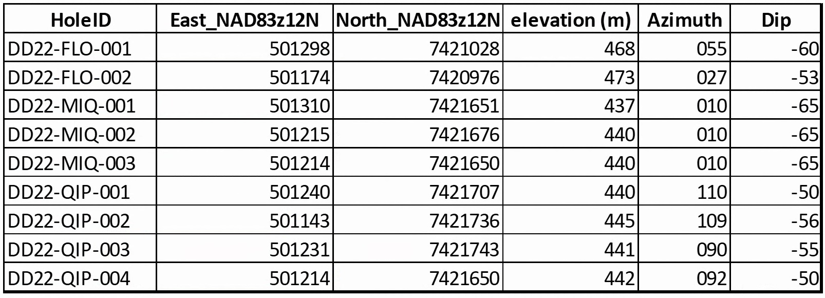
Figure 2: Table of drill collar locations for holes reported in this release.
To view an enhanced version of Figure 2, please visit:
https://images.newsfilecorp.com/files/2421/134016_fig2.jpg

Figure 3: Table of results to date.
To view an enhanced version of Figure 3, please visit:
https://images.newsfilecorp.com/files/2421/134016_fig3.jpg

Figure 4: Plan map of drill holes and progress.
To view an enhanced version of Figure 4, please visit:
https://images.newsfilecorp.com/files/2421/134016_c969a975b44c7b0d_006full.jpg

Figure 5: Plan map showing the prospects in the pipeline reviewed to date.
To view an enhanced version of Figure 5, please visit:
https://images.newsfilecorp.com/files/2421/134016_c969a975b44c7b0d_007full.jpg
Blue Star's Projects
The Company's properties are located approximately 525 km NNE of Yellowknife, NT in the Kitikmeot region of western Nunavut. The hamlet of Kugluktuk is approximately 210 km to the NW. The Roma property lies approximately 30 km north of the Ulu-Hood River property. The total area of Blue Star's projects encompasses 267 km2 of the highly prospective and underexplored High Lake Greenstone Belt.
The Ulu lease and the contiguous Hood River property together encompass greater than 12,000 hectares (120 km2) of highly prospective exploration ground. The recent acquisition of the prospective and underexplored Roma property that lies approximately 30 km north increased the Company's landholdings by more than 14,000 hectares (140 km2) in the High Lake Greenstone Belt.
The Ulu mining lease hosts the advanced stage Flood Zone gold deposit, where a significant high-grade gold resource has been outlined. Several additional gold prospects (including, but not limited to, Zebra, Contact, Central, Axis, and Gnu) are spatially related to the axis of the 5 km long Ulu Fold, which extends from the Ulu lease onto the northern part of the Hood River property and culminates at the North Fold Nose Zone. The recent expansion of the Hood River concession added several new target zones south of the Flood Zone gold deposit. The eastern side of the Hood River property is contiguous to the Ulu lease, and hosts over twenty known gold showings. The Hood River prospects have the same deformation history (including tight folding) as well as similar mineralization styles (acicular arsenopyrite and polymetallic quartz veins) and stratigraphic sequences as the Flood Zone. One of the most prospective target areas on the eastern Hood River property is the 4 km long Crown-Pro trend which has seen only limited drilling.
The Roma project lies in the northern section of the High Lake Greenstone Belt. The project covers high grade gold showings discovered by previous explorers, notably BHP Minerals from 1988 to 1994. Multiple significant gold showings are present within a 6.5 km x 2.4 km area on the historic Roma claim block. The original showing is a 0.30 to 3.0 m wide quartz vein exposed in outcrop and boulders for 2.0 km. In 1991, BHP drilled 10 shallow holes totalling 465 metres to test 1.72 km of strike of the vein. All drill holes intersected quartz veins from 15 m to 37 m vertically below surface. Visible gold was noted in three of the drillholes and the best results were 12.38 g/t Au over 2.31 m (including 64.0 g/t Au over 0.37 m) from DDH MD-01, and 8.69 g/t Au over 1.87 m from MD-03. No drilling was conducted downdip of the high-grade intersection in DDH MD-01 and no step out drilling to the north from this intercept was conducted. No follow up drilling is known to have been completed on this property since BHP's initial drill program in the 1990's. The Company has not verified the historical results from the Roma property and has presented information obtained from two assessment reports submitted by BHP Minerals Canada Ltd.; McMaster, G., (1995). Roma 3,4,5 and 6 Claims 1995 Geological and Geochemical Report, and Anonby, L. and Jopson, W., (1992). Geological, Geochemical, Geophysical and Drilling Report on the Roma 1 and 2 Claims.
The site of the future deep-water port at Gray's Bay is 40 - 100 km to the north of the properties, and the proposed route corridor for the all-weather Gray's Bay road passes in close proximity to the Roma, Ulu, and Hood River projects.
Technical Disclosure
Drill holes reported had core samples cut by core saw with one half of the core retained and the other half sent for analysis. Samples were prepared by ALS Yellowknife-Geochemistry and analyzed at ALS Global, North Vancouver. Gold analysis was by fire assay using ALS code Au-AA26 and multielement analysis by code ME-MS61. Control samples include a crush duplicate every twenty samples; certified reference material was inserted once every ten samples. Reported assay intervals are uncapped, use a minimum 1 g/t gold assay cut off with the inclusion of up to 2 m of material below cut-off. True widths for all but the Flood Zone are not known due to lack of drilling and may range from 50% to 95% of drilled lengths.
DetectORE™ Process
DetectORE™ is a new rapid geochemical analysis technique developed by Portable PPB Pty Ltd to be used at exploration sites. It enables rapid remote on-site gold results to ~20 ppb Au levels daily, instead of weeks to many months for each batch. Regional geochemical samples (1000m x 50m grid) consisting of till samples collected from frost boils are sieved to <1 mm to capture approximately 2kg of material; samples are dried with a 500 gram split used in the analysis technique which includes final reading of the sample collector devices by pXRF, reject material was also analyzed by pXRF for multi-element review and retained. The QP has ensured the QAQC program of detectORE™ includes two reference materials per processing batch (90 samples) and at least two certified collector devices are analyzed during the analysis stage. Additionally, the Company inserted one blank, one duplicate, and one known anomalous sample into the initial processing batches.
Qualified Person
Darren Lindsay, P. Geo. and Vice President Exploration for Blue Star, is a Qualified Person under National Instrument 43-101 ("NI 43-101") and has reviewed and approved the technical information contained in this news release.
About Blue Star Gold Corp.
Blue Star is a gold company focused on exploration and development within Nunavut, Canada. Blue Stars landholdings total approximately 270 square kilometres of highly prospective and underexplored mineral properties in the High Lake Greenstone Belt, Nunavut. The Company owns the Ulu Gold Property mining lease, an advanced gold project, the highly prospective Hood River Property that is contiguous to the Ulu lease, and the Roma Project. A significant high-grade gold resource exists at the Flood Zone deposit (Ulu lease), and numerous high-grade gold occurrences and priority targets occur throughout the Ulu, Hood River and Roma Projects.
Blue Star is listed on the TSX Venture Exchange under the symbol: BAU, the U.S. OTCQB Venture Market under the symbol: BAUFF, and on the Frankfurt Exchange under the symbol: 5WP0. For information on the Company and its projects, please visit our website: www.bluestargold.ca.
For further information, please contact:
Grant Ewing, P. Geo., CEO
Telephone: +1 778-379-1433
Email: info@bluestargold.ca
Neither the TSX Venture Exchange nor its Regulation Services Provider (as that term is defined in the Policies of the TSX-Venture Exchange) accepts responsibility for the adequacy or accuracy of this Release.
CAUTIONARY NOTE REGARDING FORWARD-LOOKING STATEMENTS AND INFORMATION
This press release contains "forward-looking statements" within the meaning of applicable securities laws. Forward-looking statements can be identified by words such as: "anticipate," "intend," "plan," "goal," "seek," "believe," "project," "estimate," "expect," "strategy," "future," "likely," "may," "should," "will" and similar references to future periods. Examples of forward-looking statements include, among others, statements we make regarding prospective income and revenues, anticipated levels of capital expenditures for fiscal year, expectations of the effect on our financial condition of claims, litigation, environmental costs, contingent liabilities and governmental and regulatory investigations and proceedings, and estimates of mineral resources and reserves on our properties.
Forward-looking statements are neither historical facts nor assurances of future performance. Instead, they are based only on our current beliefs, expectations and assumptions regarding the future of our business, future plans and strategies, projections, anticipated events and trends, the economy and other future conditions. Because forward-looking statements relate to the future, they are subject to inherent uncertainties, risks and changes in circumstances that are difficult to predict and many of which are outside of our control. Our actual results and financial condition may differ materially from those indicated in the forward-looking statements. Therefore, you should not rely on any of these forward-looking statements. Important factors that could cause our actual results and financial condition to differ materially from those indicated in the forward-looking statements include, among others, the following: economic and financial conditions, including volatility in interest and exchange rates, commodity and equity prices and the value of financial assets, strategic actions, including acquisitions and dispositions and our success in integrating acquired businesses into our operations, developments and changes in laws and regulations, including increased regulation of the mining industry through legislative action and revised rules and standards applied by the regulatory bodies in Nunavut, changes in the price of fuel and other key materials and disruptions in supply chains for these materials, closures or slowdowns and changes in labour costs and labour difficulties, including stoppages affecting either our operations or our suppliers' abilities to deliver goods and services to us, as well as natural events such as severe weather, fires, floods and earthquakes or man-made or other disruptions of our equipment, and inaccuracies in estimates of mineral resources and/or reserves on our mineral properties.
![]()
To view the source version of this press release, please visit https://www.newsfilecorp.com/release/134016
Source: Blue Star Gold Corp.