Vancouver, British Columbia--(Newsfile Corp. - July 13, 2022) - Tower Resources Ltd. (TSXV: TWR) ("Tower" or the "Company") is pleased to report that it has received gold assays for the final four of the six follow-up holes drilled in April on the recently discovered Lightning Zone on the Company's Rabbit North property near Kamloops, British Columbia, between New Gold's New Afton underground Cu-Au mine and Teck's Highland Valley open pit Cu-Mo mine (see Fig. 1).
The April drilling program was designed to establish the strike, dip and true thickness of the Lightning Zone to ensure that the next holes, tentatively scheduled for August, are positioned and aimed to maximize their exploration value. For the April drill holes, the Lightning Zone was assumed to strike northeast and dip vertically (see Fig. 2). However, the northeast strike direction was speculative because the gold zone is not exposed and no helpful marker horizons were intersected in the earlier discovery program.
The first two holes, RN22-028 and 029, showed that the Lightning Zone is approximately 40 m thick in the discovery area and dips steeply at -85° (see Fig. 3 and Tower's June 22, 2022 press release), but did not establish the strike of the zone.
The Au, sulphur (a measure of pyrite since the gold is not accompanied by any other sulphide minerals) and Cu results obtained from the last four holes, Nos. 030 to 033, show that the Lightning Zone is Y-shaped. Its main branch appears to strike north-northwest (see Fig. 4) but the targeted northeast trend is also well mineralized and appears to be a major splay structure, doubling the known strike length of the gold system.
Since the drilling was based on a northeast strike, the holes were aimed at the splay structure. Hole 031 still reached the Lightning Zone, cutting 22.0 m of 2.09 g/t Au and extending the zone 100 m but Holes 030 and 033 tested only the splay structure, cutting 26.5 m of 1.78 g/t Au and 1.0 m of high-grade, 69.3 g/t (2.01 oz/ton) Au, respectively. Hole 032 was drilled parallel to rather than toward the target.
Stu Averill, a seasoned geologist and Director of the Company, explained the positive implications of the change in strike direction of the Lightning Zone:
"It's still early days at the Lightning Zone so some surprises are to be expected, in this case a positive one. Despite not knowing the strike of the gold zone, we got strong hits in five of six holes, delineated a major splay structure that effectively doubles the strike length of the gold system, extended the mineralization in both structures by 100 m and showed that the prime discovery area is wide open to the southeast. Plus we now know where to aim our drill holes to maximize their effectiveness."
Holes 030 and 031 Intersect Significant Au in Splay Shear and Lightning Zone:
Holes 030 and 031 were drilled from a common pad 50 m northeast along strike from Hole 029 which intersected 70.5 m of 1.78 g/t Au in the Lightning Zone, including 13.5 m of 4.92 g/t (see Tower's June 22, 2022 press release). Both holes were drilled northwest parallel to Hole 029, with Hole 030 dipping steeply at -070° and Hole 031 flatly at -45° (see Fig. 5). Both intersected a strong shear zone - the splay shear - that dips steeply northwest at -78°, subparallel to the -70° dip of Hole 030. As a result this hole remained in strongly deformed rock throughout its 236 m length whereas Hole 031 which was of a similar, 230 m length, crossed the shear zone and succeeded in reaching the Lightning Zone.
Both holes intersected the top of the low-grade zone of porphyry-type Cu mineralization that the discovery hole encountered beneath the Lightning Zone (see Fig. 6 and Tower's Tower's June 7, 2022 press release). The top (northwest side) of the porphyry Cu zone has a steep northwest dip of 73° (see Fig. 5), similar to the dips of both the shear zone and Hole 030. Near the end of the Cu zone, Hole 030 intersected 26.5 m of 1.76 g/t Au, including 10.5 m of 3.40 g Au, followed at depth by 6.0 m of 1.71 g/t Au. The overprinting of the Au mineralization on the older Cu mineralization accounts for the visually impressive quartz veining and pyrite-chalcopyrite enrichment that was previously reported in this drill hole (see Tower's May 3, 2022 press release)
Hole 031 hit the Lightning Zone 100 m north-northwest along strike from the discovery area (see Fig. 4). It intersected the zone between 158 and 211 m down-hole over an apparent true thickness of 35 m. It encountered two mineralized zones, 6.0 m of 1.94 g/t Au in the footwall and 22.0 m of 2.09 g/t Au in the hanging wall, including 4.0 m of 6.27 g/t Au. The hole may not have passed completely through the gold zone as the bottom 10.0 m still averaged 0.27 g/t Au.
Importantly, the revelation from Hole 031 that the main branch of the Lightning Zone strikes north-northwest and remains strong in this direction for more than 100 m further implies that the zone is wide open south-southeast of the prime discovery-area intersections (see Fig. 4) rather than potentially being cut off as in the former northeast trending model.
Hole 033 Hits High-Grade Au in Splay Shear:
Hole 033 was drilled 50 m further northeast along strike from Holes 030 and 031. It was drilled to the northwest parallel to these holes at the same flat dip as Hole 031 and thus intersected the same zone of porphyry-style Cu mineralization followed by strongly deformed volcaniclastic rocks of the splay shear. Instead of the usual wide zone of low to medium-grade Au mineralization Hole 033 intersected 1.0 m of very rich mineralization grading 69.3 g/t (2.01 oz/ton) Au. This high-grade zone is only 200 m southwest along strike from and may be related to the 10 m drill intercept averaging 12.4 g/t Au in historical Hole 97-07 (see Fig. 4).
Hole 033 was collared over a large, steeply northwest dipping quartz-feldspar porphyry dyke that was also intersected deep in Hole 030 (see Fig. 5). The porphyry dyke appears to be related to the Au mineralization rather than the older Cu mineralization as it is sheared, pyritized, and typically contains 0.1-0.2 g/t Au but only 20-40 ppm Cu.
Lightning Zone Extends North-Northwest toward Another Historical Gold Hit:
A vertical hole, No 94-02, that was diamond drilled 400 m north-northwest of Holes 026, 028 and 029 in 2004 (see Fig. 4) also appears to have the hit the Lightning Zone as it intersected 74 m of 0.58 g/t Au and the mineralization displays the characteristic fracturing, bleaching, silicification and pyritization of this zone rather than the Cu-Au association of the porphyry-type mineralized zones that are associated with the nearby Durand Stock.
The gold mineralization at Hole 94-02 is hosted by diorite of the Durand Stock. The mineralized diorite is covered by 28 m of young basalt flows that were erupted from a fissure 300 m to the northeast on the summit of the Durand Stock about 8 million years ago. Part of the lava appears to have bled south-southeast along the Lightning Zone as similar basalt was intersected at the tops of Holes 025, 029 and 032. The coincidence of these young lava flows with the Lightning Zone suggests that recessive weathering of the highly fractured, gold bearing rocks prior to eruption of the basalt produced a channel that the lava exploited.
Next Drill Program:
Drilling at Rabbit North is expected to resume in August. The drilling will primarily target the extensions of the main branch of the Lightning Zone north-northwest and south-southeast of the prime discovery area.
Methods and Qualified Person
The drill core was logged at Tower's leased, fully equipped core facility near Kamloops under the supervision of Matthew Husslage, BSc. Geology, and Dane Bridge, MSc., P.Geo., both of whom have extensive experience with shear-hosted gold deposits and have previously worked on the Rabbit North property.
Split samples of the core, generally 1-2 m in length, were delivered directly to Activation Laboratories (ActLabs) in Kamloops, BC, a laboratory certified as ISO/IEC 17025 Accredited (Lab 790) by the Standards Council of Canada. QA/QC samples including blanks and standards were inserted regularly into the sample sequence at a ratio of approximately 1:20.
The samples were analyzed for Au by fire assay and ICP-OES and for Ag and 36 additional elements by ICP-OES using a four-acid, near-total digestion. Any over-limit (>5 g/t) Au analyses were repeated using the same fire assay procedure but with a gravimetric rather than ICP finish.
The technical content of this news release has been reviewed and approved by Stuart Averill, P.Geo., a Director of the Company, and a Qualified Person as defined by National Instrument 43-101.
About Tower Resources
Tower is a Canadian based mineral exploration company focused on the discovery and advancement of economic mineral projects in the Americas. The Company's key exploration assets, both in B.C., are the Rabbit North copper-gold porphyry project located between the New Afton copper-gold and Highland Valley copper mines in the Kamloops mining district and the Nechako gold-silver project near Artemis' Blackwater project.
On behalf of the Board of Directors
Tower Resources Ltd.
Joe Dhami, President and CEO
(778) 996-4730
www.towerresources.ca
Reader Advisory
This news release may contain statements which constitute "forward-looking information", including statements regarding the plans, intentions, beliefs and current expectations of the Company, its directors, or its officers with respect to the future business activities of the Company. The words "may", "would", "could", "will", "intend", "plan", "anticipate", "believe", "estimate", "expect" and similar expressions, as they relate to the Company, or its management, are intended to identify such forward-looking statements. Investors are cautioned that any such forward-looking statements are not guarantees of future business activities and involve risks and uncertainties, and that the Company's future business activities may differ materially from those in the forward-looking statements as a result of various factors, including, but not limited to, fluctuations in market prices, successes of the operations of the Company, continued availability of capital and financing and general economic, market or business conditions. There can be no assurances that such information will prove accurate and, therefore, readers are advised to rely on their own evaluation of such uncertainties. The Company does not assume any obligation to update any forward-looking information except as required under the applicable securities laws.
Neither TSX Venture Exchange nor its Regulation Services Provider (as that term is defined in policies of the TSX Venture Exchange) accepts responsibility for the adequacy or accuracy of this release.

Figure 1 - Location of Tower's Rabbit North property relative to the active mines of the Kamloops district.
To view an enhanced version of Figure 1, please visit:
https://images.newsfilecorp.com/files/5023/130690_figure1.jpg

Figure 2 - Locations of the initial 2021 exploration Holes RN21-24 to 27 (red) and recent 2022 delineation holes RN22-28 to 33 (green).
To view an enhanced version of Figure 2, please visit:
https://images.newsfilecorp.com/files/5023/130690_Figure%202.jpg
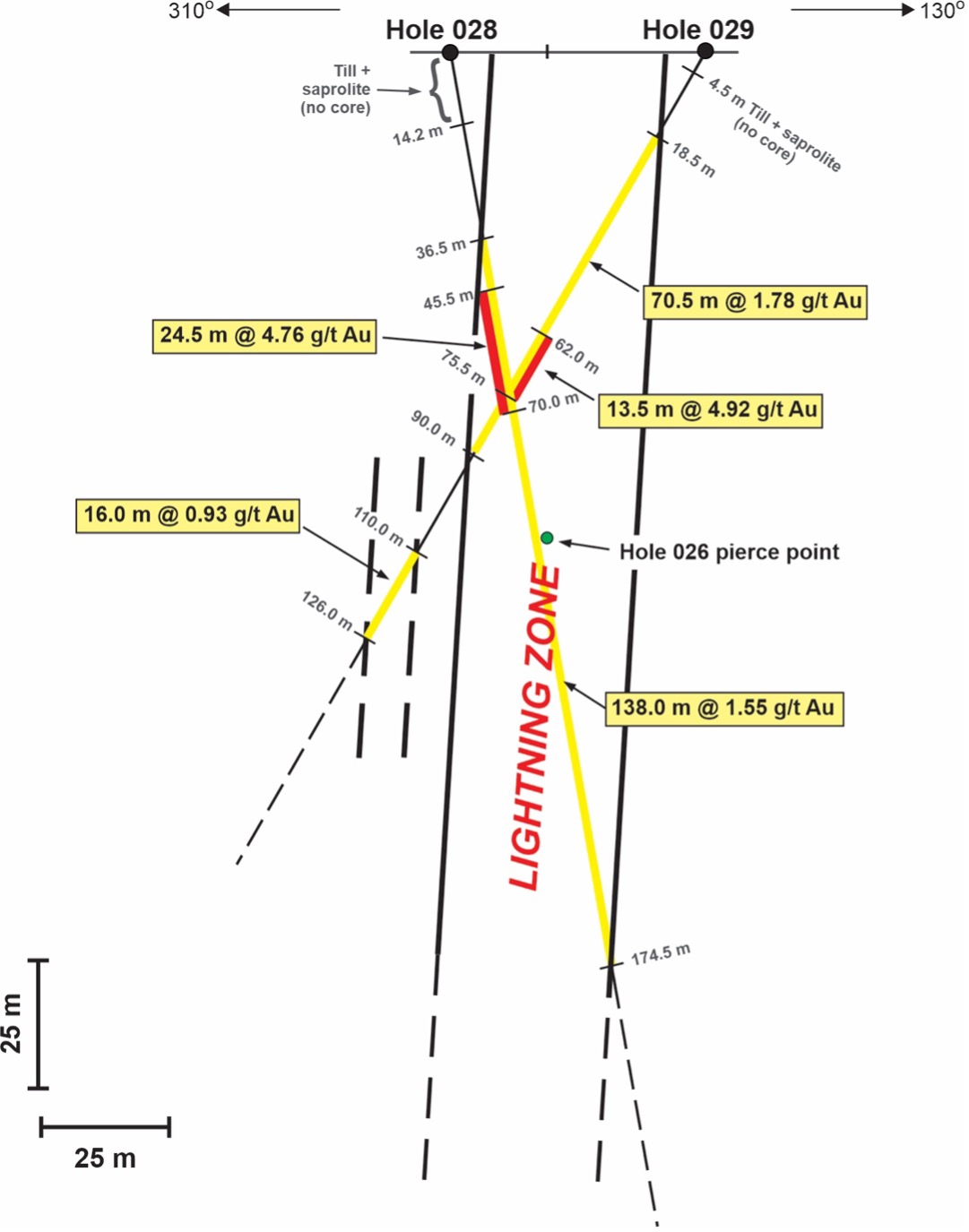
Figure 3 - NW-SE section through Holes 028 and 029 looking northeast.
To view an enhanced version of Figure 3, please visit:
https://images.newsfilecorp.com/files/5023/130690_Figure%203.jpg

Figure 4 - Plan view of drill area with main Au intercepts projected vertically to surface.
To view an enhanced version of Figure 4, please visit:
https://images.newsfilecorp.com/files/5023/130690_Figure%204.jpg
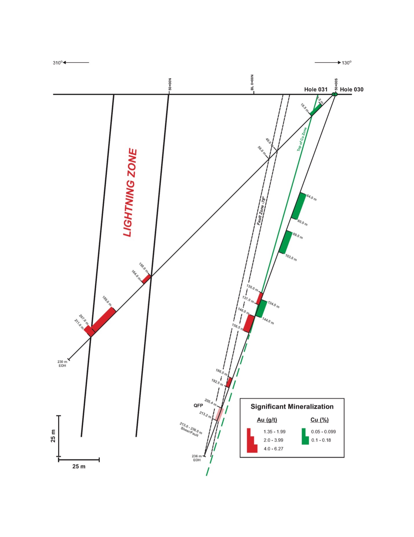
Figure 5 - NW-SE section through Holes 030 and 031 looking northeast.
To view an enhanced version of Figure 5, please visit:
https://images.newsfilecorp.com/files/5023/130690_Figure%205.jpg

Figure 6 - Section of discovery Hole 26 showing average Au and Cu analyses for significantly mineralized zones. Note that the upper limit for the red Au bars is 2.5 g/t.
To view an enhanced version of Figure 6, please visit:
https://images.newsfilecorp.com/files/5023/130690_Figure%206.jpg
To view the source version of this press release, please visit https://www.newsfilecorp.com/release/130690
Source: Tower Resources Ltd.