Toronto, Ontario--(Newsfile Corp. - November 22, 2021) - Rockcliff Metals Corporation (CSE: RCLF) (FSE: RO0A) (WKN: A2H60G) ("Rockcliff" or the "Company") is pleased to announce the filing of a National Instrument 43-101-Standards of Disclosure for Mineral Projects ("NI 43-101") technical report titled "Technical Report Bur Zone Project Manitoba, Canada" (the "Technical Report") in respect of a Mineral Resource Estimate prepared by Mr. Derek Loveday P.Geo., Project Manager of Stantec Consulting Ltd. ("Stantec") on the Bur Property.
Don Christie, interm President and CEO, commented, "We are very pleased to add a project with the significance of Bur to our existing portfolio of development projects. Bur is a material, high-grade, resource of copper and zinc which remains open in all directions and is strategically located in the active Snow Lake mining camp. We look forward to further testing the deposit in order to determine its actual size and to investigate numerous priority areas along strike of the deposit that remain underexplored."
A copy of the Technical Report is available on the Company's SEDAR issuer profile at www.SEDAR.com and the Company's website at http://rockcliffmetals.com.
The Technical Report prepared by Stantec with an effective date of October 26, 2021 is summarized below.
Bur Property Mineral Resource Estimate at 2.3% CuEq Cut-Off (1-11)
| Classification | Tonnes (k) | Cu (%) | Zn (%) | Au (g/t) | Ag (g/t) | CuEq (%) | Cu (Mlbs) | Zn (Mlbs) | Au (koz) | Ag (koz) | CuEq (Mlbs) |
| Measured | 338 | 1.54 | 3.58 | 0.05 | 12.94 | 2.87 | 11.48 | 26.68 | 0.54 | 140.62 | 21.39 |
| Indicated | 2,679 | 1.70 | 6.45 | 0.02 | 3.41 | 3.97 | 100.41 | 380.95 | 1.72 | 293.71 | 234.48 |
| Measured/Indicated | 3,017 | 1.69 | 6.13 | 0.02 | 4.48 | 3.84 | 112.37 | 407.59 | 1.94 | 434.41 | 255.33 |
| Inferred | 2.342 | 1.03 | 8.65 | 0.00 | 0.91 | 4.04 | 53.18 | 446.62 | 0.00 | 68.52 | 208.59 |
- CIM definitions are followed for classification of Mineral Resource.
- Mineral resources are contained within a mineralized vein (zone) dipping at approximately 60 degrees towards the northwest whose closest vertical depth from surface is 6 m and maximum vertical depth is 1,274 m.
- Resources are constrained to a minimum true vein thickness of 0.2 m and where calculated block revenues after recovery are greater than costs for mining.
- CuEQ (%) = Cu(%) + Zn(%) x 0.347 + Au(gpt) x 0.430 +Ag(gpt) x 0.005
- ZnEQ (%) = Cu(%) x 2.885 + Zn(%) + Au(gpt) x 1.241 + Ag(gpt) x 0.016
- CuEQ and ZnEQ formulas are calculated using the following revenue inputs: Cu US$ 3.26/lb, Zn US$ 1.13/lb, Au US$ 1,744/oz, and Ag US$ 22.05/oz. Metal recoveries are: 80% Cu, 80% Zn, 40% Au and 40% Ag.
- Mining costs used to determine prospects for eventual economic extraction total C$110/t.
- US$ to C$ exchange rate applied is 1:1.31.
- Specific gravity for the mineralized zone is fixed at 3.1.
- Totals may not represent the sum of the parts due to rounding.
- The Mineral Resource estimate has been prepared by Derek Loveday, P. Geo. of Stantec Consulting Services Ltd. in conformity with CIM "Estimation of Mineral Resource and Mineral Reserves Best Practices" guidelines and are reported in accordance with the Canadian Securities Administrators NI 43-101. Mineral resources are not mineral reserves and do not have demonstrated economic viability. There is no certainty that any mineral resource will be converted into mineral reserve.
- The 100% owned Bur Property is part of the Company's extensive Manitoba property portfolio, has excellent infrastructure with a year-round access road, clearing for portable buildings, and a box cut and portal. The Bur Property lies within the Flin Flon-Snow Lake greenstone belt ("the Belt"), the largest
- Paleoproterozoic VMS district in the world and the most prolific VMS district in Canada.
The 100% owned Bur Property is part of the Company's extensive Manitoba property portfolio (see Figure 1), has excellent infrastructure with a year-round access road, clearing for portable buildings, and a box cut and portal (see Image 1). The Bur Property lies within the Flin Flon-Snow Lake greenstone belt ("the Belt"), the largest Paleoproterozoic VMS district in the world and the most prolific VMS district in Canada.

Figure 1: Rockcliff's property portfolio (in purple) within the Flin Flon-Snow Lake greenstone belt
To view an enhanced version of this graphic, please visit:
https://orders.newsfilecorp.com/files/3071/104609_6d652e7b048b7858_001full.jpg

Image 1: Bur site is accessible by road leading to a previously constructed box-cut and portal.
To view an enhanced version of this graphic, please visit:
https://orders.newsfilecorp.com/files/3071/104609_rockcliff.png
Bur Mineralization and Resource Expansion Potential
The Bur Deposit is a sediment hosted stratiform volcanogenic massive sulphide (VMS) deposit that occurs within a narrow turbidite assemblage of interbedded metagreywacke, metasiltstone and graphitic meta-argillite in a basinal area situated between two granitic intrusions. The northeast striking deposit dips 60-70 degrees northwest, averages 2.0 metres true thick and ranges from <0.3 metres up to 9 metres thick and to date has a known lateral extent of approximately 8,000 metres. Historic and recent drilling throughout the Bur Property has encountered near surface, disseminated, semi-massive and massive sulphide mineralization below shallow overburden along a strike length of over 6,000 metres and to a vertical depth of 1,274 metres (see Figure 2). Mineralization consists of sphalerite, chalcopyrite, pyrrhotite, pyrite, galena and arsenopyrite. The Bur Deposit remains open in all directions and contains up to 20% felsic or cherty nodules consisting of wall-rock and late quartz fragments displaying a brecciated texture to the mineralization.
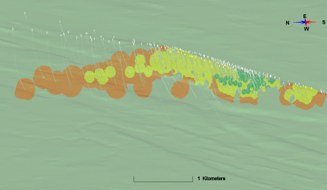
Figure 2: Bur Deposit Longitudinal Projection Highlighting Measured (green), Indicated (yellow) and Inferred (orange) Mineral Resources
To view an enhanced version of this graphic, please visit:
https://orders.newsfilecorp.com/files/3071/104609_rockcliff2.png
Resource Estimate Methodology
The Mineral Resource Estimate reported herein, considered drilling information available up to 2020 and was evaluated using a geostatistical block modeling approach constrained by polymetallic mineralization wireframes utilizing MinePlan 3D© software Version 15-80-2 modeling software. The evaluation of the Mineral Resource Estimate involved CuEq cut-off value determination, constraining wireframe solids creation, compositing, grade capping, variography, grade Interpolation and Mineral Resource Estimate quantification.
A total of 238 drill holes (totalling 107,101 metres) from the entire database were reviewed and 208 of those drill holes (totalling 101,676 metres) were utilized to create the constraining wireframes (mineralized zone). The constraining wireframes have an overall strike length of 6,060 metres, down dip projection of 1,464 metres and average true width of 2 metres. There were 1,116 assays captured by the constraining wireframes that were combined into 436 regular 1-metre composites with an average core length of 2.25 metres. A grade capping evaluation was performed and grades were capped at 6.5% for copper (Cu), 30% for zinc (Zn), 0.35 g/t for gold (Au) and 40 g/t for silver (Ag). The capped composites were evaluated using variography to determine the grade interpolation search ranges and also used for resource assurance (classification). Resource classification is influenced by distance to the nearest drill hole sample composite, age of the exploration data and number of drill hole intercepts through the mineralized zone. For measured resources, a minimum of 3 sampled intercepts within 50 metres from Rockcliff-only drill holes is used as a guide. For indicated resources 3 sampled drill hole intercepts up to 100 mtertes and for inferred a minimum of one sampled intercept per drill hole up to 200 metres is used as a guide.
Grade interpolation was undertaken from 1-metre regular drillhole composited through the mineralized zone into a horizontally rotated 3D block model orientated along strike (045 degrees) of the mineralized zone. An ID3 method of estimation was used for Cu, Zn, Au and Ag grade data that was estimated in a regular block size of 20 metres along stike, 2.5 metres across-strike and 5 metres vertical. Bulk density was derived from 61 specific gravity (SG) measurements taken from within the mineralized zone that ranged from a minimum of 2.76 to 3.76, generating a median and average SG of 3.1. Density from within the mineralized zone for resource reporting was fixed at 3.1. The subsequent block model grades and tonnages were quantified for the Mineral Resource Estimate at a 2.3% CuEq cut-off value.
Neither Rockcliff's Qualified Person, Ken Lapierre, P.Geo., nor Stantec's Qualified Person, Derek Loveday, P.Geo., nor management of Rockcliff are aware of any known environmental, permitting, legal, title, taxation, socio-political, marketing or other relevant issues that may materially affect the estimate of the Mineral Resource.
Quality Control and Quality Assurance
Samples of half core were packaged and shipped directly from Rockcliff's core facility in Snow Lake to TSL Laboratories (TSL), in Saskatoon, Saskatchewan. TSL is a Canadian assay laboratory and is accredited under ISO/IEC 17025. Each bagged core sample was dried, crushed to 70% passing 10 mesh and a 250g pulp is pulverized to 95% passing 150 mesh for assaying. A 0.5g cut is taken from each pulp for base metal analyses and leached in a multi acid (total) digestion and then analyzed for copper, lead, zinc and silver by atomic absorption. Gold concentrations are determined by fire assay using a 30g charge followed by an atomic absorption finish. Samples greater than the upper detection limit (3000 ppb) are reanalyzed using fire assay gravimetric using a 1 assay ton charge. Rockcliff inserted certified blanks and standards in the sample stream to ensure lab integrity. Rockcliff has no relationship with TSL other than TSL being a service provider to the Company.
The Mineral Resource for the Bur Property disclosed in this press release has been estimated by Mr. Derek Loveday, P.Geo. a Project Manger for Stantec and is independent of Rockcliff. By virtue of his education and relevant experience Mr. Loveday is a "Qualified Persons" for the purpose of National Instrument 43-101. Mr. Loveday has read and approved the technical contents of this press release as it pertains to the disclosed Mineral Resource Estimate.
Ken Lapierre P.Geo., VP Exploration of Rockcliff, a Qualified Person in accordance with Canadian regulatory requirements as set out in NI 43-101, has read and approved the scientific and technical information that forms the basis for the disclosure contained in this press release.
About Rockcliff Metals Corporation
Rockcliff is a Canadian resource development and exploration company with several advanced-stage, high-grade copper and VMS dominant deposits in the Snow Lake area of central Manitoba. The Company is a major landholder in the Belt which is the largest Paleoproterozoic VMS district in the world, hosting high-grade mines and deposits containing copper, zinc, gold and silver. The Company's extensive portfolio of properties totals approximately 4,000 km² and includes seven of the highest grade, undeveloped VMS deposits in the Belt. Rockcliff has a joint venture with Hudbay at the Company's 49% owned Talbot Copper Deposit.
For more information, please visit http://rockcliffmetals.com
YouTube: Rockcliff Metals Corporation
Twitter: @RockcliffMetals
LinkedIn: Rockcliff Metals Corp
Instagram: Rockcliff_Metals
Facebook: Rockcliff Metals Corporation
For further information, please contact:
Rockcliff Metals Corporation
Don Christie
Interm President & CEO
Cell: (416) 409-8441
don@rockcliffmetals.com
Cautionary Note Regarding Forward-Looking Statements:
This news release contains "forward-looking information" within the meaning of applicable Canadian securities laws. Generally, these forward-looking statements can be identified by the use of forward-looking terminology such as "plans", "expects", "budget", "scheduled", "estimates", "forecasts", "intends", "anticipates", or "believes", or the negatives and / or variations of such words and phrases, or state that certain actions, events or results "may", "could", "would", "might" or "will be taken", "occur", "be achieved" or "has the potential to". In particular, the forward-looking statements in this press release include, without limitation, statements regarding: future projected production, capital costs and operating costs, recovery methods and rates, development methods and plans, commodity prices and Mineral Resource Estimates. Statements relating to "Mineral Resources" are deemed to be forward-looking information, as they involve the implied assessment that, based on certain estimates and assumptions, the Mineral Resources described can be profitably produced in the future.
Forward looking statements are based on the certain assumptions opinions and estimates as of the date such statements are made, and they are subject to known and unknown risks, uncertainties and other factors that may cause the actual results, level of activity, performance or achievements of the Company to be materially different from those expressed or implied by such forward-looking statements. Factors that could cause actual results to differ materially from those in forward-looking statements include: delays resulting from the COVID-19 pandemic, changes in market conditions, unsuccessful exploration results, possibility of project cost overruns or unanticipated costs and expenses, changes in the costs and timing of the development of new deposits, inaccurate resource estimates, changes in the price of copper or zinc, unanticipated changes in key management personnel and general economic conditions. Mining exploration and development is an inherently risky business. The Company believes that the expectations reflected in the forward-looking statements are reasonable but no assurance can be given that these expectations will prove to be accurate and results may differ materially from those anticipated in the forward-looking statements. For a discussion in respect of risks and other factors that could influence forward-looking statements, please refer to the factors discussed in the Company's Management Discussion and Analysis for the year ended March 31, 2021 under the heading 'Risk Factors'. These factors are not and should not be construed as being exhaustive.
Accordingly, readers should not place undue reliance on forward-looking statements. The forward-looking information contained in this news release is expressly qualified by this cautionary statement. Any forward-looking information and the assumptions made with respect thereto speaks only as of the date of this news release. The Company does not undertake any obligation to publicly update or revise any forward-looking information after the date of this news release to conform such information to actual results or to changes in the Company's expectations except as otherwise required by applicable legislation.
![]()
To view the source version of this press release, please visit https://www.newsfilecorp.com/release/104609
Source: Rockcliff Metals Corp.