Montreal, Quebec--(Newsfile Corp. - November 9, 2021) - Beauce Gold Fields (TSXV: BGF) (Champs D'Or en Beauce), ("BGF"): is pleased to announce it has completed the sampling of the Chesham & Ditton sand and gravel pits on the Company's Megantic placer to hardrock exploration property located in southern Quebec. The sampling was to further investigate gold anomalies along the southern section of the Bella Fault line that returned up to 10 grams per ton first identified on the Chesham as well as on various sections of the property (see BGF press releases of April 12 & 23, 2021).
Patrick Levasseur, President and CEO of Beauce Gold Fields said, "We found important gold anomalies along a fault line that crosses historical placer gold deposits." Mr. Levasseur added: "It's an area of Quebec that has been totally under explored that's providing exciting opportunities for important new discoveries."
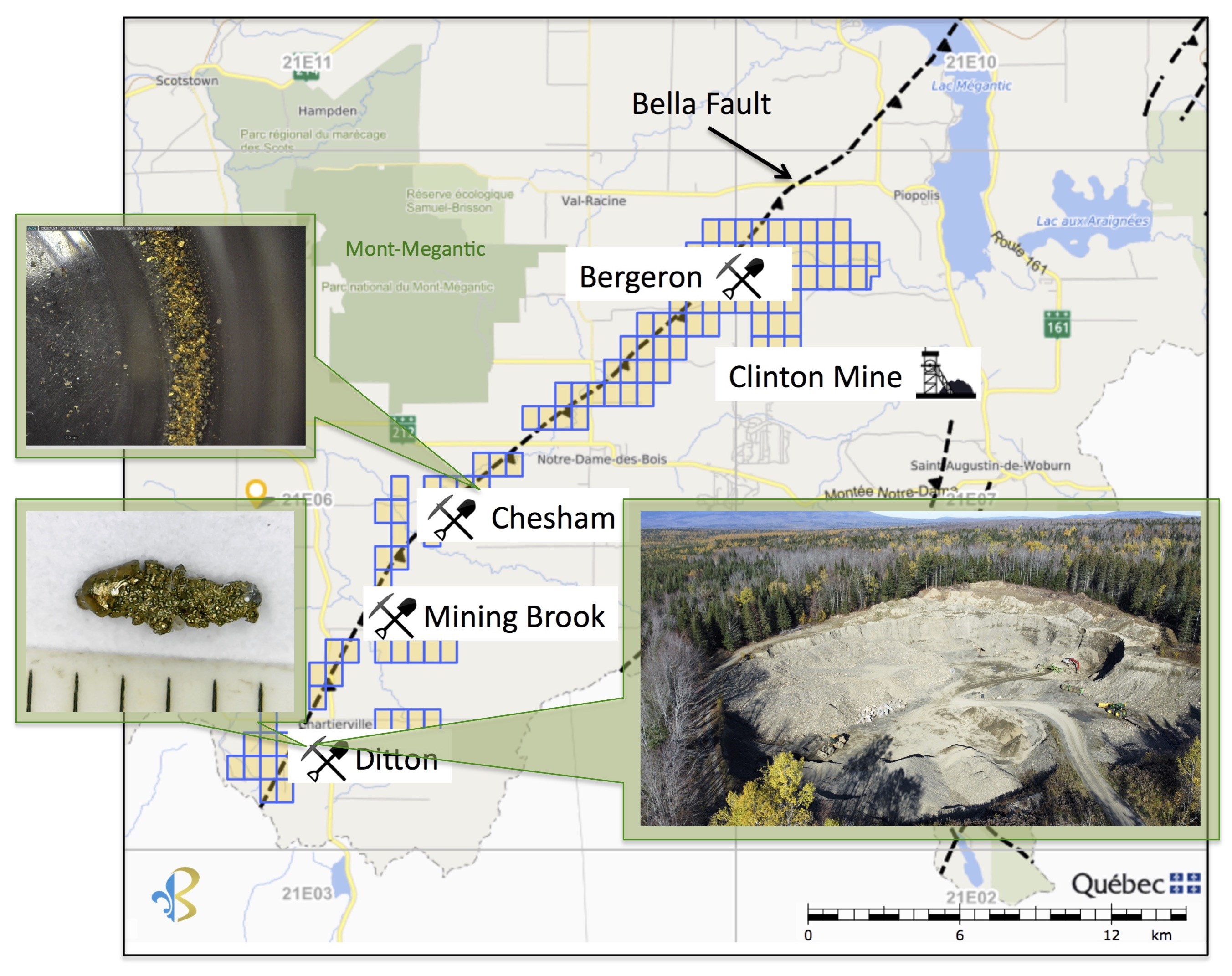
Image 1: Megantic Property Map, Gold samples and Ditton Quarry sand pit
To view an enhanced version of this graphic, please visit:
https://orders.newsfilecorp.com/files/6198/102643_9e292850b4f2697f_001full.jpg
Chesham Sector
29 sand and gravel samples of glaciofluvial material were collected from a sand pit quarry, which was active in the 1980s. BGF returned to this area to further explore around the site were a fine sand sample taken in 2020 returned more than 10 g / t Au (BGF press releases of April 23, 2021)
The sand & gravel deposit covers an area of more than 6 hectares. It is located approximately 100m west of Chesham Creek and to the south of Mont-Mégantic.
Sampling was undertaken using a medium-sized excavator (approximately 30 to nnes). The thickness of the deposit varies between 1m to more than 8 meters deep. The maximum extension of the excavator's boom could not exceed 7m in depth therefore in some places, it could measure more than 8m. The sedimentary sequence of the entire deposit consists mainly of medium to fine sand from the top down to gravel at its base. The 2021 excavations at times reached, after having crossed the layers of sand-gravel, beds of clay, bedrock or a water table that would fill the trenches. In October 2021, a stratigraphic cut of approximately 2.0m in height was sampled down an escarpment of the quarry. It intersected the section where the 10g/ton Au #798541 2020 sample was collected.
Ditton Sector
10 samples taken from an operating gravel pit located near the town of La Patrie in Ditton township. The part of the quarry occupies approximately an area of 0.5 hectares. A series of 10 sand and gravel samples were taken along the walls and under the floor of the gravel pit. Vertical thicknesses of the sand & gravel deposit varied from 2m to more than 13m.
Sample SB16, which was taken at random from the gravel by BGF, showed the presence of a very coarse gold grain that measured more than 4mm.

Image 2: 4 mm gold grain from sample #SB16
To view an enhanced version of this graphic, please visit:
https://orders.newsfilecorp.com/files/6198/102643_9e292850b4f2697f_002full.jpg
In 1985, Cache Explorations undertook a series of overburden drill holes in the vicinity of the Ditton and Mining Brook areas. A churn drill hole (Hole 85-7 GM42843) 400m west of the quarry returned important gold values. Hole 85-7 intercepted a gold zone at 11.4m to 20.2m deep. A sample taken at 11.85 to 12.38m showed up to 65 fine gold grains (-1mg).
All 39 samples were collected in 50 lbs buckets and sent to ExploLab in Val D'Or Quebec for gravimetric methods of gold separation and analysis. Jean Bernard, B,Sc. Geo., is a qualified person as defined by NI 43-101 who supervised the sampling program and has reviewed and approved the technical information presented in this release.
About the Megantic Property
The Mégantic property extends southwest to the USA border of New Hampshire and to the northeast to Lac Mégantic. The property extends for at least 30 km along the axis of the Bella Fault. It is divided into four sectors of past placer gold mines & of historical gold showings: the Ditton, the Mining Brook, the Chesham and Bergeron rivers. The intent of Beauce Gold Fields is to trace placer gold back to a bedrock source to uncover economic bedrock gold mineralization.
About Beauce Gold Fields
Beauce Gold Fields is a gold exploration company focused on placer to hard rock exploration in the Beauce region of Southern Quebec. The Company's flagship property is the St-Simon-les-Mines Gold project site of Canada's first gold rush that pre-dates the Yukon Klondike. The Beauce region hosted some of the largest historical placer gold mines in Eastern North America that were active from 1860s to the 1960s It produced some of the largest gold nuggets in Canadian mining history (50oz to 71oz). The intent of Beauce Gold Fields is to trace the placer gold workings back to the bedrock source and uncover economic bedrock gold mineralization.
Comprising 152 contiguous claims and 7 real estate lots, the project area contains a six-kilometer long placer gold channel consisting of unconsolidated gold-bearing auriferous units of a lower saprolite and an upper brown diamictite.
The Company has identified a major Fault Line in bedrock that coincides with geophysical findings of an interpreted fault structure across the property, referred to herein as the AMT Shear. Evidence suggests the erosion of the AMT Fault or related splay fractures as a probable source of the historical placer gold channel, and has conducted bedrock sampling and geophysics outside the expression of the placer gold channel. This is the target of the current drill program.
Beauce Gold Fields website www.beaucegold.com
Disclaimers:
This press release contains certain forward-looking statements, including, without limitation, statements containing the words "may", "plan", "will", "estimate", "continue", "anticipate", "intend", "expect", "in the process" and other similar expressions which constitute "forward-looking information" within the meaning of applicable securities laws. Forward-looking statements reflect the Company's current expectation and assumptions, and are subject to a number of risks and uncertainties that could cause actual results to differ materially from those anticipated. These forward-looking statements involve risks and uncertainties including, but not limited to, our expectations regarding mineral exploration. Such statements reflect the current views of the Company with respect to future events and are subject to certain risks and uncertainties and other risks detailed from time-to-time in the Company's on-going filings with the securities regulatory authorities, which filings can be found at www.sedar.com. Actual results, events, and performance may differ materially. Readers are cautioned not to place undue reliance on these forward-looking statements. The Company undertakes no obligation to publicly update or revise any forward-looking statements either as a result of new information, future events or otherwise, except as required by applicable securities laws.
Neither the TSX Venture Exchange nor its Regulation Services Provider (as that term is defined in the policies of the TSX Venture Exchange) accepts responsibility for the adequacy or accuracy of this release.
For further information contact
Patrick Levasseur, President and CEO Tel: (514) 262-9239
Bernard J. Tourillon, Chairman and COO Tel (514) 907-1011
www.beaucegold.com
![]()
To view the source version of this press release, please visit https://www.newsfilecorp.com/release/102643
Source: Beauce Gold Fields Inc