Toronto, Ontario--(Newsfile Corp. - July 6, 2021) - Roscan Gold Corporation (TSXV: ROS) (FSE: 2OJ) (OTC Pink: RCGCF) ("Roscan" or the "Company") is pleased to announce positive results (Figure 1) from an additional 14 DD and RC holes totaling 3,066 meters (m) at our Southern Mankouke Zone (MS1 and MS3). MS1 confirms mineralization open at depth and MS3 shows potential high-grade extension to the west.
Drilling Highlights:
Mankouke Discovery Zone (MS1)
- 1.43 gpt gold over 10m from drill hole DDMAN21-104B from 309.3m
- Including 6.27 gpt gold over 1m from 318.3m
- 2.02 gpt gold over 25m from drill hole DDMAN21-104B from 329.3m
- Including 5.97 gpt gold over 4m from 332.3m
- 2.33 gpt gold over 14m from drill hole DDMAN21-107 from 141.0m
- Including 5.62 gpt gold over 2m from 142.0m
- and 2.27 gpt gold over 9.8m from 158.0m
- Including 6.08 gpt gold over 1.8m from 165.0m
- 1.58 gpt gold over 18m from drill hole DDMAN21-101 from 1.3m
- and 8.43 gpt gold over 8m from 22.3m
- including 18.22 gpt gold over 4m from 25.3m
- and 7.18 gpt gold over 9m from 56.3m
- including 11.78 gpt gold over 5m from 59.3.3m
Mankouke Discovery Zone (MS3)
- 2.33 gpt gold over 18m from drill hole DDMAN21-106 from 53.3m
- Including 4.95 gpt gold over 4m from 57.3m
Notes: 1: True width yet to be determined, 2: Table 1 - Assay Highlights, 3: 0.5gpt used as cut-off with 4m internal dilution for drill holes, and 4: No top-cut.
Main Mankouke South Zone (MS1) - Confirms Mineralization Open at Depth
Additional results from the main Southern Mankouke Zone (MS1) confirm the occurrence of high-grade mineralization at depth, in the fresh rock, as demonstrated with Hole DDMan21-104B. It is the deepest high-grade intercept in bedrock to date, showing strong continuity over multiple intervals (Table 1), and it remains open at depth beyond 300 meters vertical depth (Figure 2).
Additionally, Holes DDMan21-101 and DDMan21-107 continue to confirm the high-grade nature of MS1, showing that mineralization is a clearly defined with consistency over wide intercepts. MS1 has now been traced over a strike length of 550 meters and as wide as 150 meters in certain parts and to a depth of 300 metres vertical. Figure 4 points to several plunging shoots at good grades that could be traced down to 130 meters depth.
Mankouke Discovery Zone (MS3) - Potential High-Grade Extension to the West
At the MS3 Discovery Zone, where previous drilling results (DDMan20-62, 64, 67, 69) had established a 200 meters north south mineralized trend, DDMan20-106 with 2.33 gpt gold over 18m from 53.3m indicates a potential high-grade mineralization extension to the west (Figure 3). Additional follow up drilling has been completed, pending results.
Nana Sangmuah, President and CEO, stated, "We continue to be very encouraged with our flagship target Mankouke South, which again has delivered results that reinforce our geological thesis that we are on top of a system with multiple parallel zones starting at surface and with significant potential at depth. Hole 104B, the highest grade and depth to date at the Main Mankouke South Zone (MS1), points to a potential feed source and warrants follow up.
The plunging shots also confirm this thesis of high grade at depth, a fact corroborated as well with the geophysics showing the existence of conductors as deep as over 1km. These results strengthen our interpretation of good potential at depth, which we would be testing in due course.
This batch of drilling has also further expanded the footprint at Mankouke Discovery Zone (MS3), with Hole 106 indicating mineralization at MS3 not only is traced north to south but also extends to the west, expanding toward the recently acquired Mankouke West permit, where we have just completed a large first pass drilling program and are eagerly awaiting assays.
With approximately 20,000 metres of drilling results yet to be received, we are looking forward to providing further updates in the near future as more assays become available."
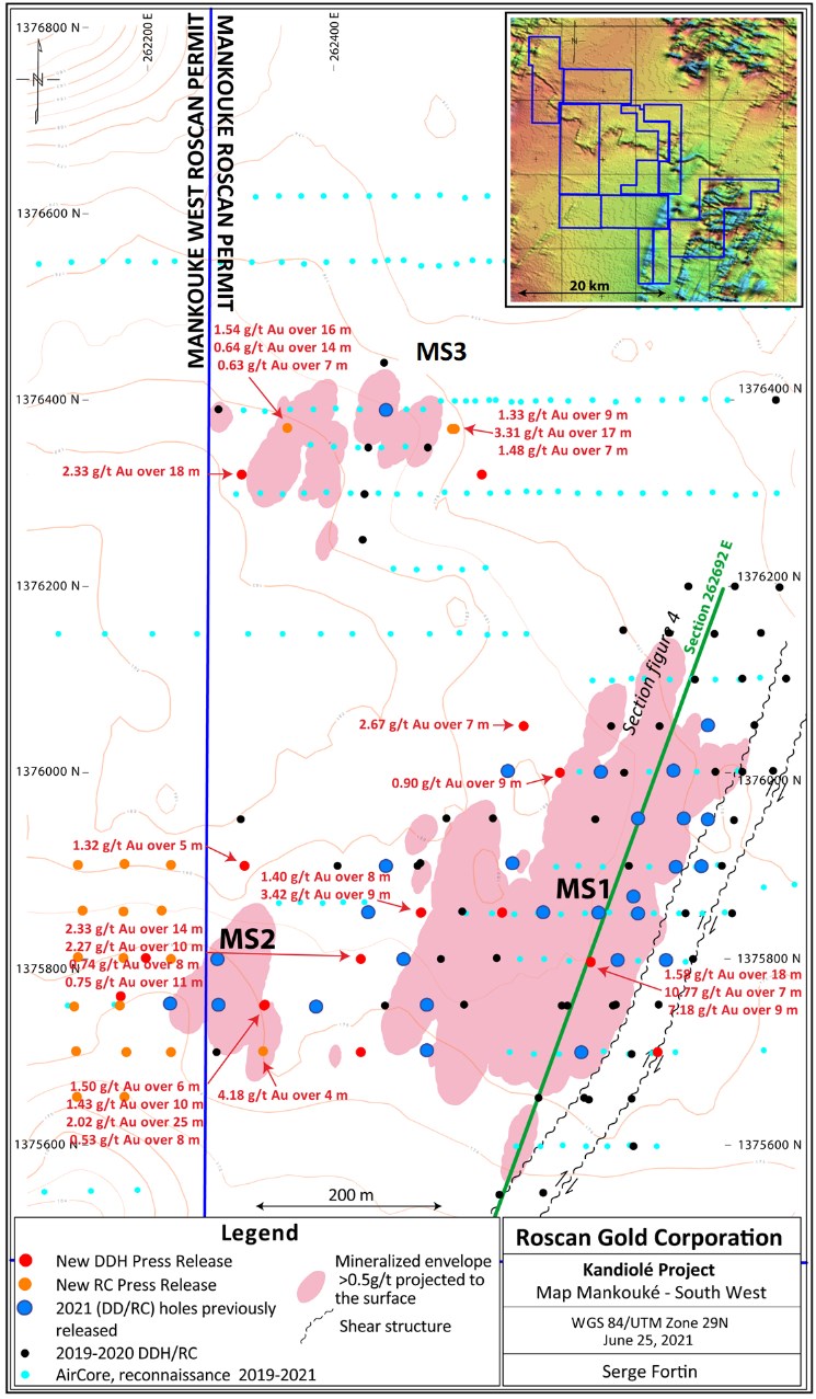
Figure 1: Plan View of the Mankouke Drilling (MS1, MS2 and MS3)
To view an enhanced version of Figure 1, please visit:
https://orders.newsfilecorp.com/files/4821/89419_ddd833fe0473abb1_001full.jpg

Figure 2: Cross Section Depicting Depth Extension with DDMan21-104B at MS1
To view an enhanced version of Figure 2, please visit:
https://orders.newsfilecorp.com/files/4821/89419_ddd833fe0473abb1_002full.jpg

Figure 3: Cross Section Depicting West Extension at MS3 - DDMan21-106
To view an enhanced version of Figure 3, please visit:
https://orders.newsfilecorp.com/files/4821/89419_ddd833fe0473abb1_003full.jpg

Figure 4: Long section along the mineralization strike
To view an enhanced version of Figure 4, please visit:
https://orders.newsfilecorp.com/files/4821/89419_ddd833fe0473abb1_004full.jpg
Geology
The gold mineralization at Mankouke South is located approximately 25km east of the Fekola mine (B2Gold Corp.), but also along a prospective major NE-SW structural corridor from Siribaya-Diaka (IAMGOLD Corporation) to Seko (Oklo Resources Limited). Gold mineralization in Mankouke South occurs within hydrothermally altered and sheared metasediments of the Kofi formation which include greywacke, limestone and diamictite but also in the edge of a felsic intrusive cross cutting the sedimentary package.
The Mankouke South mineralization is located within the sheared eastern limb of a fold directly above a footwall unit of finely banded and alternating graphitic shale and limestone referred to as the dirty limestone ("DLS"). The border north of the mineralization corresponds with the edge of a NE-SW conductive zone from the geophysics surveys but MS3 also overlays the beginning of a Nord East conductive lineament. The gold mineralization is associated with a strong alteration over several lithologies, mainly albite, silicification, ankerite and chlorite, with the sulfite occurrences (pyrite, arsenopyrite) but also fracturing and quartz veins and veinlets.

Figure 5: Drill Core Photo DDMan21-104B showing high grade sections mineralization in the altered felsic intrusive at MS1
To view an enhanced version of Figure 5, please visit:
https://orders.newsfilecorp.com/files/4821/89419_ddd833fe0473abb1_005full.jpg

Figure 6: Drill Core Photo DDMan21-106 showing broadly high-grade Sections in saprolite-saprock at MS3
To view an enhanced version of Figure 6, please visit:
https://orders.newsfilecorp.com/files/4821/89419_ddd833fe0473abb1_006full.jpg
Drilling Contract and Analytical Protocol
Roscan uses Air Core (AC), Reverse Circulation (RC) and Diamond (DDH) types of drilling in the Kandiole Projects. The Air Core drilling is mainly applied to drill early exploration targets.
The samples are sent for preparation to the Bureau Veritas Mineral Laboratories in Bamako, Mali and assayed at their analytical facilities for fire assay with atomic absorption finish and by gravimetric finish for grades above 10gpt Au.
Table 1: Drillhole Highlights at Mankouke (July 6th, 2021)
| Hole ID | From (m) | To (m) | Interval (m) | gpt Au | Comment |
| DDMAN21-98 | 386.5 | 391.5 | 5 | 1.32 | Fresh Rock |
| including | 389.5 | 390.5 | 1 | 3.57 | Fresh Rock |
| 395.5 | 397.5 | 2 | 1.07 | Fresh Rock | |
| 413.5 | 414.5 | 1 | 0.87 | Fresh Rock | |
| DDMAN21-99 | 177.4 | 178.4 | 1 | 5.70 | Fresh Rock |
| DDMAN21-100 | 44.6 | 45.6 | 1 | 0.67 | Saprolite |
| 56.6 | 60.6 | 4 | 7.39 | Saprolite | |
| including | 57.6 | 59.6 | 2 | 14.35 | Saprolite |
| 67.6 | 68.6 | 1 | 0.68 | Saprolite | |
| 80.6 | 84.6 | 4 | 1.24 | Saprolite | |
| 126.6 | 127.6 | 1 | 0.55 | Saprolite | |
| DDMAN21-101 | 1.3 | 19.3 | 18 | 1.58 | Laterite - Saprolite |
| including | 11.3 | 12.3 | 1 | 4.09 | Laterite |
| including | 18.3 | 19.3 | 1 | 4.27 | Saprolite |
| 22.3 | 31.3 | 8 | 8.43 | Saprolite | |
| including | 25.3 | 29.3 | 4 | 18.22 | Saprolite |
| 39.3 | 42.3 | 3 | 1.03 | Saprolite | |
| 44.3 | 45.3 | 1 | 0.64 | Saprolite | |
| 56.3 | 65.3 | 9 | 7.18 | Saprolite | |
| including | 59.3 | 64.3 | 5 | 11.78 | Saprolite |
| 68.3 | 71.3 | 3 | 3.94 | Saprolite | |
| including | 69.3 | 70.3 | 1 | 9.38 | Saprolite |
| DDMAN21-102 | 137.4 | 144.4 | 7 | 2.67 | Saprock - Fresh Rock |
| including | 141.4 | 142.4 | 1 | 14.10 | Fresh Rock |
| DDMAN21-104 | 71.4 | 72.4 | 1 | 0.57 | Saprolite |
| DDMAN21-104B | 98.3 | 103.3 | 5 | 0.68 | Fresh Rock |
| 282.3 | 283.3 | 1 | 0.87 | Fresh Rock | |
| 285.3 | 286.3 | 1 | 1.82 | Fresh Rock | |
| 290.3 | 291.3 | 1 | 0.67 | Fresh Rock | |
| 294.3 | 300.3 | 6 | 1.50 | Fresh Rock | |
| including | 299.3 | 300.3 | 1 | 5.60 | Fresh Rock |
| 309.3 | 319.3 | 10 | 1.43 | Fresh Rock | |
| including | 318.3 | 319.3 | 1 | 6.27 | Fresh Rock |
| 323.3 | 325.3 | 2 | 1.07 | Fresh Rock | |
| 329.3 | 354.3 | 25 | 2.02 | Fresh Rock | |
| including | 332.3 | 336.3 | 4 | 5.97 | Fresh Rock |
| 358.3 | 360.3 | 2 | 1.14 | Fresh Rock | |
| 367.3 | 375.3 | 8 | 0.53 | Fresh Rock | |
| DDMAN21-106 | 19.3 | 20.3 | 1 | 0.84 | Saprolite |
| 41.3 | 43.3 | 2 | 1.06 | Saprolite | |
| 45.3 | 47.3 | 2 | 1.87 | Saprolite - Saprock | |
| 53.3 | 71.3 | 18 | 2.33 | Fresh Rock | |
| including | 57.3 | 61.3 | 4 | 4.95 | Fresh Rock |
| including | 65.3 | 66.3 | 1 | 4.41 | Fresh Rock |
| 75.3 | 76.3 | 1 | 0.99 | Saprock | |
| DDMAN21-107 | 141.0 | 155.0 | 14 | 2.33 | Saprolite |
| including | 142.0 | 144.0 | 2 | 5.62 | Saprolite |
| 158.0 | 167.8 | 9.8 | 2.27 | Fresh Rock | |
| including | 165.0 | 166.8 | 1.8 | 6.08 | Fresh Rock |
| 174.8 | 175.8 | 1 | 3.38 | Fresh Rock | |
| 198.8 | 206.8 | 8 | 0.74 | Fresh Rock | |
| including | 205.8 | 206.8 | 1 | 2.24 | Fresh Rock |
| 218.8 | 229.8 | 11 | 0.75 | Fresh Rock | |
| including | 223.8 | 224.8 | 1 | 2.42 | Fresh Rock |
| 248.8 | 249.8 | 1 | 1.59 | Fresh Rock | |
| DHMAN21-109 | 108.1 | 109.1 | 1 | 1.82 | Saprock |
| 129.1 | 133.1 | 4 | 1.12 | Fresh Rock | |
| RCMAN21-19 | 60.0 | 63.0 | 3 | 1.09 | Saprolite |
| 68.0 | 69.0 | 1 | 0.88 | Saprolite | |
| RCMAN21-21 | 2.0 | 6.0 | 4 | 4.18 | Laterite |
| 114.0 | 118.0 | 4 | 1.33 | Saprolite | |
| RCMAN21-22B | 32.0 | 41.0 | 9 | 1.33 | Saprolite-Saprock |
| including | 34.0 | 35.0 | 1 | 7.39 | Saprolite |
| 45.0 | 62.0 | 17 | 3.31 | Fresh Rock | |
| including | 48.0 | 51.0 | 3 | 6.31 | Fresh Rock |
| including | 55.0 | 58.0 | 3 | 5.88 | Fresh Rock |
| 87.0 | 94.0 | 7 | 1.48 | Fresh Rock | |
| RCMAN21-23 | 10.0 | 26.0 | 16 | 1.54 | Saprolite |
| including | 23.0 | 26.0 | 3 | 4.37 | Saprolite |
| 30.0 | 32.0 | 2 | 0.69 | Saprolite | |
| 41.0 | 55.0 | 14 | 0.64 | Saprolite-Saprock | |
| 60.0 | 67.0 | 7 | 0.63 | Saprock |
Table 2: Drillhole ID at Mankouke (July 6th, 2021)
| Hole ID | X Collar | Y Collar | Zcolar | Section | AZM | DIP | EOH |
| DDMAN21-98 | 262304 | 1375900 | 180.56 | 1375900 | 90 | -60 | 461.5 |
| DDMAN21-99 | 262748 | 1375700 | 177.03 | 1375700 | 90 | -50 | 250.0 |
| DDMAN21-100 | 262581 | 1375850 | 179.61 | 1375850 | 90 | -50 | 239.4 |
| DDMAN1-101 | 262676 | 1375797 | 177.91 | 1375797 | 90 | -50 | 206.3 |
| DDMAN21-102 | 262604 | 1376050 | 179.03 | 1376050 | 90 | -50 | 166.4 |
| DDMAN21-103 (*) | 262901 | 1376050 | 174.52 | 1376050 | 270 | -50 | 199.5 |
| DDMAN21-104 | 262325 | 1375750 | 176.42 | 1375750 | 90 | -50 | 93.4 |
| DDMAN21-104B | 262325 | 1375750 | 176.42 | 1375750 | 90 | -50 | 404.3 |
| DDMAN21-105 (*) | 262559 | 1376320 | 184.91 | 1376320 | 90 | -50 | 240.7 |
| DDMAN21-106 | 262301 | 1376320 | 181.70 | 1376320 | 90 | -50 | 240.7 |
| DDMAN21-107 | 262429 | 1375800 | 177.78 | 1375800 | 90 | -50 | 271.8 |
| DDMAN21-108 (*) | 262898 | 1376050 | 174.52 | 1376050 | 270 | -50 | 243.3 |
| DDMAN21-109 | 262429 | 1375700 | 175.27 | 1375700 | 90 | -50 | 272.0 |
| RCMAN21-19 | 262225 | 1375800 | 174 | 1375800 | 90 | -50 | 100.0 |
| RCMAN21-21 | 262324 | 1375701 | 166 | 1375700 | 90 | -50 | 120.0 |
| RCMAN21-22B | 262530 | 1376369 | 173 | 1376370 | 270 | -50 | 120.0 |
| RCMAN21-23 | 262350 | 1376370 | 175 | 1376370 | 90 | -50 | 120.0 |
(*) Not Significant Results
Qualified Person (QP) and NI43-101 Disclosure
Greg Isenor, P. Geo., Director for the Company, is the designated Qualified Person for this news release within the meaning of National Instrument 43-101 ("NI 43-101") and has reviewed and verified that the technical information contained herein is accurate and approves of the written disclosure of same.
About Roscan
Roscan Gold Corporation is a Canadian gold exploration company focused on the exploration and acquisition of gold properties in West Africa. The Company has assembled a significant land position of 100%-owned permits in an area of producing gold mines (including B2 Gold's Fekola Mine which lies in a contiguous property to the west of Kandiole), and major gold deposits, located both north and south of its Kandiole Project in West Mali.
For further information, please contact:
Greg Isenor, P.Geo
Director
Tel: (902) 221-2329
Email: gpisenor@Roscan.ca
Forward Looking Statements
This news release contains forward-looking information which is not comprised of historical facts. Forward-looking information is characterized by words such as "plan", "expect", "project", "intend", "believe", "anticipate", "estimate" and other similar words, or statements that certain events or conditions "may" or "will" occur. Forward-looking information involves risks, uncertainties and other factors that could cause actual events, results, and opportunities to differ materially from those expressed or implied by such forward-looking information. Factors that could cause actual results to differ materially from such forward-looking information include, but are not limited to, changes in the state of equity and debt markets, fluctuations in commodity prices, delays in obtaining required regulatory or governmental approvals, and other risks involved in the mineral exploration and development industry, including those risks set out in the Company's management's discussion and analysis as filed under the Company's profile at www.sedar.com. Forward-looking information in this news release is based on the opinions and assumptions of management considered reasonable as of the date hereof, including that all necessary governmental and regulatory approvals will be received as and when expected. Although the Company believes that the assumptions and factors used in preparing the forward-looking information in this news release are reasonable, undue reliance should not be placed on such information. The Company disclaims any intention or obligation to update or revise any forward-looking information, other than as required by applicable securities laws.
Neither the TSX Venture Exchange nor its Regulation Services Provider (as that term is defined in the policies of the TSX Venture Exchange) accepts responsibility for the adequacy or accuracy of this release.
![]()
To view the source version of this press release, please visit https://www.newsfilecorp.com/release/89419
Source: Roscan Gold Corporation