Road Town, Tortola, British Virgin Islands--(Newsfile Corp. - February 9, 2021) - Talon Metals Corp. (TSX: TLO) ("Talon" or the "Company") is pleased to provide an update on the Tamarack Nickel-Copper-Cobalt Project ("Tamarack Nickel Project"), located in Minnesota, USA. The Tamarack Nickel Project comprises the Tamarack North Project and the Tamarack South Project.

Figure 1: Portion of Drill Hole 20TK0277, representing 39.03 meters (128 feet) of semi-massive sulphide mineralization starting at 347.15 meters (Drill hole 20TK0277)
To view an enhanced version of Figure 1, please visit:
https://orders.newsfilecorp.com/files/2443/73969_70cdf1fa346da93e_001full.jpg
HIGHLIGHTS
- Drill hole 20TK0277 intersected a total of 110.65 meters (363 feet) of semi-massive and disseminated sulphide mineralization, starting at 341.07 meters (see Figure 1). Assays remain pending.
- This drill hole was a 25 meter step out into an undrilled area in the northern portion of the Tamarack Nickel Project's current resource area.
"The more we learn about the Tamarack Nickel Project - even within the project's existing resource area - the better the project seems to get," said Brian Goldner, Head of Exploration for Talon. "We are excited to have drilled this thick intercept of 110.65 meters (363 feet) of semi-massive and disseminated sulphide mineralization in the northern portion of the Tamarack Nickel project's resource area. In addition to successfully intercepting mineralization as predicted by the Company's current resource model, we also intercepted 51.82 meters (170 feet) of disseminated sulphide mineralization below the current resource model."
SUMMARY
One of Talon's key catalysts for value creation in 2021 is to grow the Tamarack Nickel Project's current resource towards the north, while aiming to reduce the timeline to production. Drill hole 20TK0277 was testing an open area in the northern portion of the Tamarack Nickel Project's resource area where it was inferred to host additional semi-massive sulphide (SMSU) mineralization.
Drill hole 20TK0277 intersected a total of 110.65 meters (363 feet) of semi-massive and disseminated sulphide mineralization, starting at 341.07 meters, as follows:
58.83 meters (193 feet) of 15 to 50% sulphide mineralization, starting at 341.07 meters (see Figures 2 and 3).
Of note, within this larger intercept, there is 39.03 meters (128 feet) of semi-massive sulphide mineralization (approximately 50% sulphide mineralization) starting at 347.15 meters (see Figure 3).
- Within a deeper portion of the same drill hole (starting at 402.03 meters), the Company intersected a second interval of an additional 51.82 meters (170 feet) of approximately 10% sulphide mineralization (see Figures 2 and 3). This second intercept is only 2.03 meters below the intercept above it.
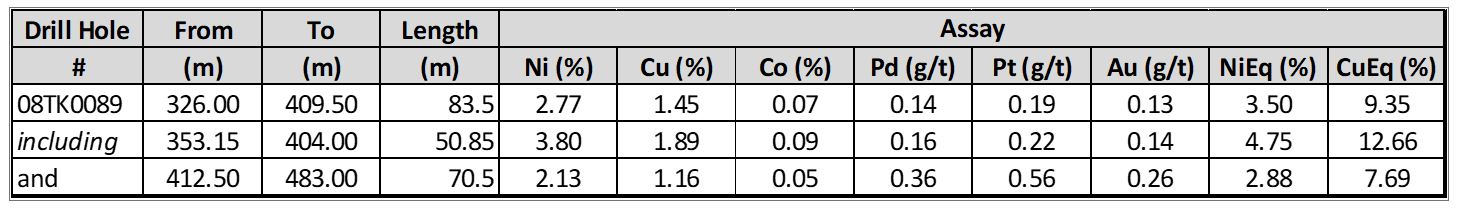
Drill hole 20TK0277 was a 25 meter step out from historic drill hole 08TK0089, which intersected 83.5 meters (274 feet) of sulphide mineralization grading 2.77% Ni, 1.45% Cu, 0.07% Co, 0.14 g/t Pd, 0.19 g/t Pt and 0.13 g/t Au (3.5% NiEq1 or 9.35% CuEq2), starting at 326 meters (see Figure 3), including a semi-massive sulphide intercept of 50.85 meters (167 feet) grading 3.80% Ni, 1.89% Cu, 0.09% Co, 0.16 g/t Pd, 0.22 g/t Pt, 0.14 g/t Au (4.75 % NiEq or 12.66 % CuEq), starting at 353.15 meters. Within the same drill hole, there was an additional lower interval of 70.5 meters (229 feet) of 2.13% Ni, 1.16% Cu, 0.05% Co, 0.36 g/t Pd, 0.56 g/t Pt and 0.26 g/t Au (2.88% NiEq or 7.69% CuEq), starting at 412.50 meters.
These results confirm the extension of semi-massive sulphide mineralization in this location.
____________________
1 Where used in this press release NiEq% = Ni%+ Cu% x $3.00/$8.00 + Co% x $12.00/$8.00 + Pt [g/t]/31.103 x $1,300/$8.00/22.04 + Pd [g/t]/31.103 x $700/$8.00/22.04 + Au [g/t]/31.103 x $1,200/$8.00/22.04
2 Where used in this press release CuEq% = Cu%+ Ni% x $8.00/$3.00 + Co% x $12.00/$3.00 + Pt [g/t]/31.103 x $1,300/$3.00/22.04 + Pd [g/t]/31.103 x $700/$3.00/22.04 + Au [g/t]/31.103 x $1,200/$3.00/22.04

Figure 2: Plan view of the Tamarack Nickel Project's resource area showing the location of new drill hole 20TK00277 within the SMSU
To view an enhanced version of Figure 2, please visit:
https://orders.newsfilecorp.com/files/2443/73969_70cdf1fa346da93e_002full.jpg

Figure 3: Cross-section (25 meters thick) looking north showing the location of drill hole 20TK0277 relative to drill hole 08TK0089, within the Semi-Massive Sulphide Unit (SMSU)
To view an enhanced version of Figure 3, please visit:
https://orders.newsfilecorp.com/files/2443/73969_70cdf1fa346da93e_003full.jpg
QUALITY ASSURANCE, QUALITY CONTROL AND QUALIFIED PERSONS
Please see the technical report entitled "NI 43-101 Technical Report Updated Preliminary Economic Assessment (PEA) of the Tamarack North Project - Tamarack, Minnesota" with an effective date of March 12, 2020 prepared by independent "Qualified Persons" (as that term is defined in National Instrument 43-101 ("NI 43-101") Leslie Correia (Pr. Eng), Andre-Francois Gravel (P. Eng.), Tim Fletcher (P. Eng.), Daniel Gagnon (P. Eng.), David Ritchie (P. Eng.), Oliver Peters (P. Eng.), Christine Pint (P.G.) and Brian Thomas (P. Geo.) for information on the QA/QC, analytical and testing procedures at the Tamarack Project. Copies are available on the Company's website (www.talonmetals.com) or on SEDAR at (www.sedar.com). The laboratory used is ALS Minerals who is independent of the Company.
Lengths are drill intersections and not necessarily true widths. True widths cannot be consistently calculated for comparison purposes between holes because of the irregular shapes of the mineralized zones. Drill intersections have been independently selected by Talon. Drill composites have been independently calculated by Talon. The geological interpretations in this news release are solely those of the Company.
The locations and distances highlighted on all maps in this news release are approximate.
Dr. Etienne Dinel, Vice President, Geology of Talon, is a Qualified Person within the meaning of NI 43-101. Dr. Dinel is satisfied that the analytical and testing procedures used are standard industry operating procedures and methodologies, and he has reviewed, approved and verified the technical information disclosed in this news release, including sampling, analytical and test data underlying the technical information.
ABOUT TALON
Talon is a TSX-listed base metals company in a joint venture with Rio Tinto on the high-grade Tamarack Nickel-Copper-Cobalt Project located in Minnesota, USA, comprised of the Tamarack North Project and the Tamarack South Project. Talon has an earn-in to acquire up to 60% of the Tamarack Project. The Tamarack Project comprises a large land position (18km of strike length) with numerous high-grade intercepts outside the current resource area. Talon is focused on expanding its current high-grade nickel mineralization resource prepared in accordance with NI 43-101; identifying additional high-grade nickel mineralization; and developing a process to potentially produce nickel sulphates responsibly for batteries for the electric vehicles industry. Talon has a well-qualified exploration and mine management team with extensive experience in project management.
For additional information on Talon, please visit the Company's website at www.talonmetals.com or contact:
Sean Werger
President
Talon Metals Corp.
Tel: (416) 361-9636 x102
Email: werger@talonmetals.com
FORWARD-LOOKING STATEMENTS
This news release contains certain "forward-looking statements". All statements, other than statements of historical fact that address activities, events or developments that the Company believes, expects or anticipates will or may occur in the future are forward-looking statements. These forward-looking statements reflect the current expectations or beliefs of the Company based on information currently available to the Company. Such forward-looking statements include statements relating to the timing and results of the exploration program, including assay results, grades, geophysical results and potential. Forward-looking statements are subject to significant risks and uncertainties and other factors that could cause the actual results to differ materially from those discussed in the forward-looking statements, and even if such actual results are realized or substantially realized, there can be no assurance that they will have the expected consequences to, or effects on the Company.
Any forward-looking statement speaks only as of the date on which it is made and, except as may be required by applicable securities laws, the Company disclaims any intent or obligation to update any forward-looking statement, whether as a result of new information, future events or results or otherwise. Although the Company believes that the assumptions inherent in the forward-looking statements are reasonable, forward-looking statements are not guarantees of future performance and accordingly undue reliance should not be put on such statements due to the inherent uncertainty therein.
Table 1. Drill Holes Discussed in this Press Release
| Tamarack Resource Area | ||||||
| HOLE ID | Easting (m) | Northing (m) | Elevation (masl) | Azimuth | Dip | End Depth (m) |
| 20TK0277 | 490846.4 | 5168866.3 | 388.9 | 237.3 | -75.6 | 603.7 |
| 08TK0089 | 490840.0 | 5168865.0 | 389.0 | 231.8 | -80.9 | 505.7 |
Collar coordinates are UTM Zone 15N, NAD83.
Azimuths and dips are taken from survey record at collar unless otherwise noted
Table 2. Assays Discussed in this Press Release
To view an enhanced version of Table 2, please visit:
https://orders.newsfilecorp.com/files/2443/73969_talonimage1.jpg
Length refers to drill hole length and not True Width.
True Width is unknown at the time of publication.
All samples were analysed by ALS Minerals. Nickel, copper, and cobalt grades were first analysed by a 4-acid digestion and ICP AES (ME-MS61). Grades reporting greater than 0.25% Ni and/or 0.1% Cu, using ME-MS61, trigger a sodium peroxide fusion with ICP-AES finish (ICP81). Platinum, palladium and gold are initially analyzed by a 50g fire assay with an ICP-MS finish (PGM-MS24). Any samples reporting >1g/t Pt or Pd trigger an over-limit analysis by ICP-AES finish (PGM-ICP27) and any samples reporting >1g/t Au trigger an over-limit analysis by AAS (Au-AA26).
No adjustments were made for recovery or payability.
NiEq% = Ni%+ Cu% x $3.00/$8.00 + Co% x $12.00/$8.00 + Pt [g/t]/31.103 x $1,300/$8.00/22.04 + Pd [g/t]/31.103 x $700/$8.00/22.04 + Au [g/t]/31.103 x $1,200/$8.00/22.04
CuEq% = Cu%+ Ni% x $8.00/$3.00 + Co% x $12.00/$3.00 + Pt [g/t]/31.103 x $1,300/$3.00/22.04 + Pd [g/t]/31.103 x $700/$3.00/22.04 + Au [g/t]/31.103 x $1,200/$3.00/22.04
Table 3. Quick Lithology Log for Drill Hole 20TK0277
| HOLE ID | FROM (m) | To (m) | Length | Quick Log | % Sulphides |
| 20TK0277 | 0 | 29.87 | OB | ||
| 20TK0277 | 29.87 | 313.64 | FGO/MZNO | ||
| 20TK0277 | 313.64 | 341.07 | CGO | 5% | |
| 20TK0277 | 341.07 | 347.15 | 6.08 | CGO | 15% |
| 20TK0277 | 347.15 | 386.18 | 39.03 | SMSU | 50% |
| 20TK0277 | 386.18 | 399.9 | 13.72 | CGO | 25% |
| 20TK0277 | 399.9 | 402.03 | CGO | ||
| 20TK0277 | 402.03 | 453.85 | 51.82 | CGO | 10% |
| 20TK0277 | 453.85 | 505.86 | 52.01 | CGO |
OB: Overburden
FGO/MZNO: Fine-Grained Orthocumulate Olivine / Mixed-Zone
CGO: Coarse-Grained Orthocumulate Olivine
SMSU: Semi-Massive Sulphide Unit
To view the source version of this press release, please visit https://www.newsfilecorp.com/release/73969
Source: Talon Metals Corp.