Toronto, Ontario--(Newsfile Corp. - October 1, 2020) - Appia Energy Corp. (CSE:API) (OTCQB:APAAF) (FSE: A0I.F) (FSE: A0I.MU) (FSE: A0I.BE) (the "Company" or "Appia") is pleased to announce the completion of 2,506.8 metres ("m") of diamond drilling in 18 drill holes (the "Program") on the Company's Alces Lake high-grade rare earth element ("REE") property (the "Property"), northern Saskatchewan.
Highlights from the drill program include:
- the intersection of the REE minerals system (the "System") over 875 m strike length, as deep as 340 m from surface, still open in all directions (3D space), and in two sub-parallel trends;
- confirmed extension of high-grade REE mineralization over a distance of 145 m within the 875 m strike length, which represents the amalgamation of the Wilson, Richard, Charles and Bell high-grade zones, now referred to as the WRCB zone;
- diamond drilling successfully correlated the ground audiomagnetotellurics ("AMT") geophysical survey interpretations with the System, and;
- a high success rate of drilling with 15 out of 18 drill holes intersecting the System.
See Figure 1 for a location map of the drill hole collars and traces, and Table 1 for a summary of results from all 18 drill holes.
Mr. James Sykes, Vice-President, Exploration and Development, comments: "The results of the Program have achieved a number of milestones. We have successfully confirmed high-grade mineralization over 145 m strike length at the WRCB zone, and we've also identified two trends of the System occurring over a 875 m strike length, which defines our current drill limits. The System was intersected down to 340 m vertical depth, which indicates this System is large and extensive. We've identified both structural and lithological controls on the System, the latter having an importance for the rest of the Property as we're seeing a direct relationship between the System and i) an Archean/Paleoproterozoic transition and ii) an amphibolite layer, both of which provide first-order controls on the location of emplacement of the pegmatites (and REE mineralization) within the System. The amphibolite layer also hosts the System at the Oldman River showing (see News Release dated September 3, 2020). This suggests that the System, and both first-order lithological emplacement controls, could be present across the entire 45 km geological strike length of the Property at/near surface and continuing at depth. We're also excited about the drill hole results confirming the AMT geophysical interpretations. This provides a key exploration tool for us, as we now have a targeting tool to assist with continued depth investigations by diamond drilling."
RICHARD ZONE DRILLING
Drill holes RI-20-003 through RI-20-007 were targeting the continuity of high-grade REE mineralization from the Wilson to Charles zones. Drill holes RI-20-004 and RI-20-005 successfully intersected semi-massive monazite occurrences. This suggests the Wilson, Richard, Charles and Bell zones are all contiguous at depth and over a strike length of 145 m. Drill holes RI-20-003, RI-20-006 and RI-20-007 were designed to test the limits of the high-grade REE mineralization, but were also exploring for geological parameters that could help future exploration programs identify key vectors that would lead to high-grade REE mineralization.
EXPLORATION DRILLING
Drill holes DN-20-001, DN-20-003, DN-20-004, and ER-20-001 were all short exploration holes down to drill depths between 20 and 30 m testing for near-surface continuity of the System in the Danny (DN) and Ermacre (ER) areas. All four drill holes successfully intersected the System and have provided invaluable geological information for continued exploration in those areas.
Drill holes CO-20-002, HN-20-001, WI-20-008, and WI-20-009 were all deep exploration holes, targeting drill depths between 170 and 330 m and have successfully proven the existence of multiple lens shaped zones (4 to 5 discrete zones) with variable thickness ranging from 5 cm to 9.4 m thick, with an average thickness of 1.0 m. The latter three drill holes contained visibly disseminated monazite in some of the intersections.
These drill holes will help provide a geological context for targeting thicker occurrences of the System with future exploration programs. The larger intersections in the drill holes have discrete lithological controls, most notably an Archean/Paleoproterozoic transition and an amphibolite layer. These lithological controls suggest that the larger parts of the System are continuous over the 875 m strike length of the drilling defined domain, and possibly across the entire 45 km geological strike length of the Property. The thinner intersections of the System tend to be discontinuous from drill hole to drill hole, however some of these intersections are oriented in directions that were sub-parallel to drilling, suggesting continuity is possible with other mineralized zones.
GEOPHYSICAL DRILLING
Drill holes CO-20-001, DN-20-002 and WI-20-005 through WI-20-007 were all designed to help improve the interpretation of a one-line, AMT geophysical survey that was completed by Advanced Geophysical Operations and Services ("AGCOS") of Markham, Ontario, during Phase I of the summer exploration period (see News Release dated June 29, 2020). Two iterations of geophysical interpretations were used to target geophysical anomalies with the drill holes. The latter iteration has provided the Company with results that match with drill hole intersections. The Company will continue to work with AGCOS to further refine their interpretation and to follow-up with a larger geophysical program next summer.
Mr. Sykes further comments: "We want to thank our drill contractor, Apex Diamond Drilling Ltd. ("Apex") of Smithers, British Columbia, and our helicopter support, Vortex Helicopters of Fort McMurray, Alberta, for their professional and efficient work. The Program started late due to the global COVID-19 pandemic, which affected receipt of permits, but Apex still completed over 2,500 m of diamond drilling in four weeks with one drill, which is very productive by industry standards. Unfortunately, the Program was cut short due to unfavourable weather conditions."
ALCES LAKE SUMMARY
Since detailed exploration began at Alces Lake in 2017, a total of seventy-four (74) REE and uranium bearing surface zones and occurrences of the System have been discovered on the Property. To date, less than 1% of the Property has been explored with diamond drilling. The Property is located in Saskatchewan, the same provincial jurisdiction that has planned to develop a "first-of-its-kind" rare earth processing facility in Canada, which is scheduled to become operational by 2022.
The Property encompasses some of the highest-grade total and critical rare earth elements ("CREE") mineralization in the world. CREE is defined here as those rare earth elements that are in short-supply and high-demand for use in permanent magnets and modern electronic applications such as electric vehicles and wind turbines, (i.e: neodymium (Nd), praseodymium (Pr) dysprosium (Dy), and terbium (Tb)). The Alces Lake project area is 17,577 hectares (43,434 acres) in size and is 100% owned by Appia. The project is located close to an old mining camp with existing support services, such as transportation (i.e., 15 km from the nearest trail), energy infrastructure (hydroelectric power), a 1,200 m airstrip that receives daily scheduled services, and access to heavy equipment.
Drill core samples have been delivered to the Saskatchewan Research Council Geoanalytical Laboratory, an ISO/IEC 17025:2005 (CAN-P-4E) certified laboratory in Saskatoon, SK, for major element and REE analysis. Results will be released once received and interpreted by the Company.
The technical content in this news release was reviewed and approved by Dr. Irvine R. Annesley, P.Geo, Advisor to Appia's Board of Directors, and a Qualified Person as defined by National Instrument 43-101.
About Appia
Appia is a Canadian publicly-listed company in the uranium and rare earth element sectors. The Company is currently focusing on delineating high-grade critical rare earth elements ("REE") and uranium on the Alces Lake property, as well as prospecting for high-grade uranium in the prolific Athabasca Basin on its Loranger, North Wollaston, and Eastside properties. The Company holds the surface rights to exploration for 57,048 hectares (140,968 acres) in Saskatchewan.
The Company also has a 100% interest (subject to a 1% Uranium Production Payment Royalty and a 1% Net Smelter Return Royalty on any precious or base metals payable, provided that the price of uranium is greater than US$130 per pound) in 12,545 hectares (31,000 acres), with rare earth element and uranium deposits over five mineralized zones in the Elliot Lake Camp, Ontario. The Camp historically produced over 300 million pounds of U3O8 and is the only Canadian camp that has had significant rare earth element (yttrium) production. The deposits are largely unconstrained along strike and down dip.
Appia's technical team is directed by James Sykes, who has had direct and indirect involvement with over 550 million lbs. U3O8 being discovered in five deposits in the Athabasca Basin.
Appia has 79.7 million common shares outstanding, 97.8 million shares fully diluted.
For more information, visit Appia's website at www.appiaenergy.ca.
Cautionary Note Regarding Forward-Looking Statements: This News Release contains forward-looking statements which are typically preceded by, followed by or including the words "believes", "expects", "anticipates", "estimates", "intends", "plans" or similar expressions. Forward-looking statements are not guarantees of future performance as they involve risks, uncertainties and assumptions. We do not intend and do not assume any obligation to update these forward- looking statements and shareholders are cautioned not to put undue reliance on such statements.
Neither the Canadian Securities Exchange nor its Market Regulator (as that term is defined in the policies of the CSE) accepts responsibility for the adequacy or accuracy of this release.
For further information, please contact:
Tom Drivas, President, CEO and Director: (tel) 416-546-2707, (fax) 416-218-9772 or (email) appia@appiaenergy.ca
James Sykes, VP Exploration & Development, (tel) 306-221-8717, (fax) 416-218-9772 or (email) jsykes@uraniumgeologist.com
Frank van de Water, Chief Financial Officer and Director, (tel) 416-546-2707, (fax) 416-218-9772 or (email) fvandewater@rogers.com
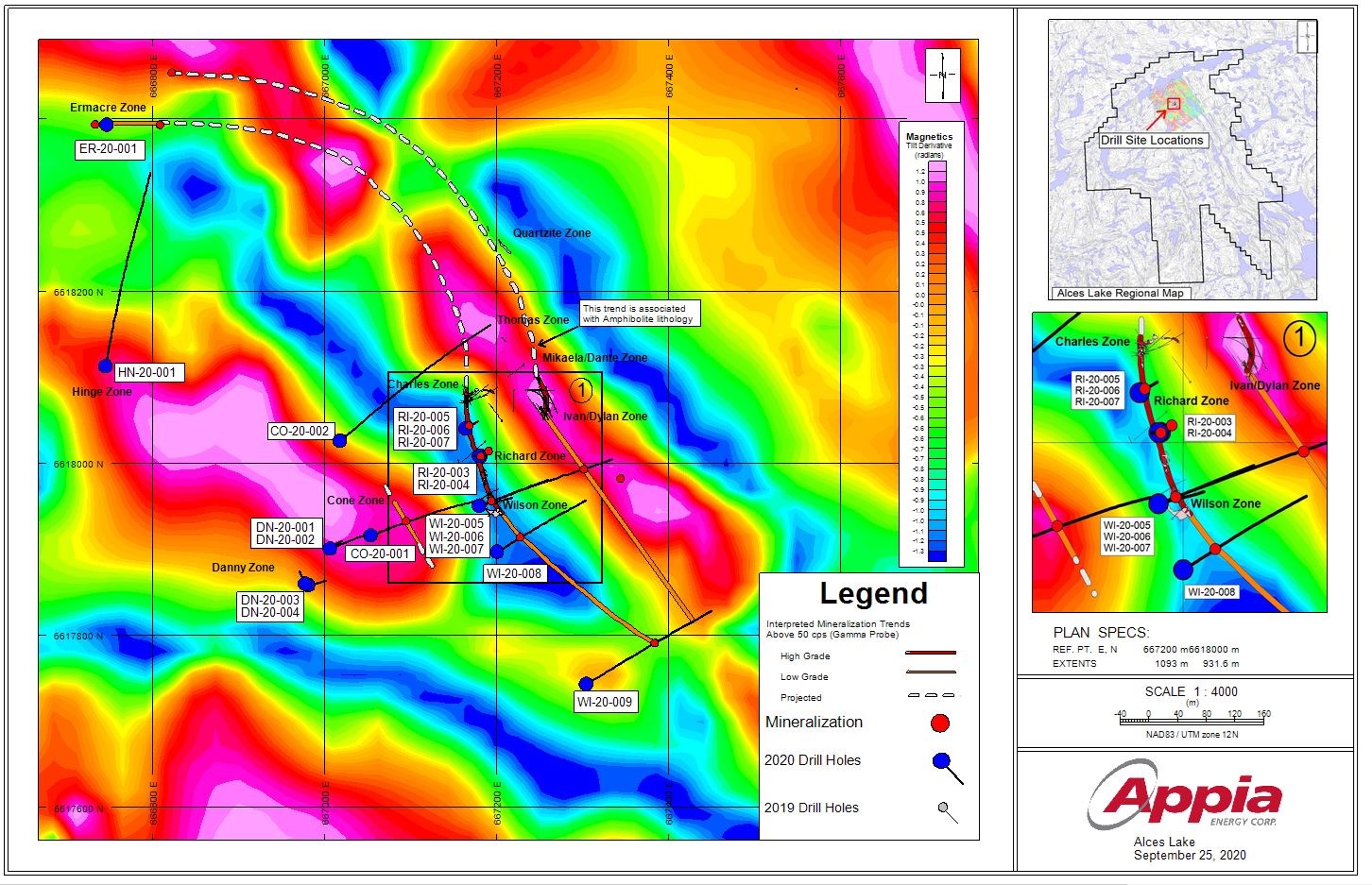
Figure 1 - Alces Lake property; Summer 2020 surface assay results
To view an enhanced version of this graphic, please visit:
https://orders.newsfilecorp.com/files/5416/65034_d13158d204efc963_005full.jpg
Table 1 - Alces Lake property; Summer 2020 diamond drilling information
| DDH | Target Area | Easting (m) | Northing (m) | Elevation (mASL) | Azimuth | Dip | EOH (m) | Minerals System (Y/N) | # of Minerals System Occurrences |
| CO-20-001 | Cone (CO) | 667053.05 | 6617916.02 | 495.83 | 70 | -65 | 285.6 | Y | 9 |
| CO-20-002 | Cone (CO) | 667017.54 | 6618026.19 | 496.87 | 50 | -45 | 306.6 | Y | 5 |
| DN-20-001 | Danny (DN) | 667005.90 | 6617900.73 | 499.06 | 50 | -45 | 23.5 | Y | 1 |
| DN-20-002 | Danny (DN) | 667005.90 | 6617900.73 | 499.06 | 50 | -85 | 368.8 | Y | 6 |
| DN-20-003 | Danny (DN) | 666980.58 | 6617858.27 | 499.61 | 75 | -45 | 29.3 | Y | 2 |
| DN-20-004 | Danny (DN) | 666977.14 | 6617859.98 | 499.52 | 335 | -45 | 23.2 | Y | 2 |
| ER-20-001 | Ermacre (ER) | 666746.51 | 6618393.62 | 432.86 | 275 | -45 | 20.4 | Y | 1 |
| HN-20-001 | Hinge (HN) | 666745.03 | 6618112.91 | 480.80 | 10 | -45 | 326.1 | Y | 5 |
| RI-20-003 | Richard (RI) | 667181.08 | 6618008.34 | 451.42 | 75 | -65 | 26.8 | N | 0 |
| RI-20-004 | Richard (RI) | 667179.34 | 6618008.09 | 450.95 | 255 | -90 | 26.8 | Y | 1 |
| RI-20-005 | Richard (RI) | 667163.45 | 6618040.48 | 450.58 | 60 | -45 | 23.8 | Y | 1 |
| RI-20-006 | Richard (RI) | 667163.45 | 6618040.48 | 450.58 | 60 | -65 | 23.8 | N | 0 |
| RI-20-007 | Richard (RI) | 667163.45 | 6618040.48 | 450.58 | 60 | -60 | 23.8 | N | 0 |
| WI-20-005 | Wilson (WI) | 667179.23 | 6617950.58 | 465.59 | 70 | -45 | 230.4 | Y | 3 |
| WI-20-006 | Wilson (WI) | 667179.23 | 6617950.58 | 465.59 | 70 | -80 | 198.1 | Y | 6 |
| WI-20-007 | Wilson (WI) | 667179.23 | 6617950.58 | 465.59 | 70 | -60 | 165.9 | Y | 5 |
| WI-20-008 | Wilson (WI) | 667200.02 | 6617897.20 | 472.45 | 60 | -45 | 170.1 | Y | 4 |
| WI-20-009 | Wilson (WI) | 667303.66 | 6617743.24 | 484.34 | 60 | -45 | 233.8 | Y | 4 |
| n = 18 | 2506.8 | n = 15 | avg = 3 per DDH |
Drill hole coordinates (Easting, Northing) are provided in NAD83, UTM Zone 12N format
![]()
To view the source version of this press release, please visit https://www.newsfilecorp.com/release/65034