Vancouver, British Columbia--(Newsfile Corp. - September 9, 2025) - Gold Finder Resources Ltd. (TSXV: GLD) (OTCQB: GLDFF) ("Gold Finder" or the "Company") is pleased to announce the results of the summer field program at its 100%-owned West Madsen Property ("the Property").
"The identification of new gold-in-soil anomalies along regional structural corridors, which host high-grade gold occurrences west of the Property and major gold deposits east of the Property, will aid in the systematic exploration along these structures," said Greg Lytle, President of Gold Finder. "These corridors are already known to contain anomalous gold over significant widths locally along the 8-kilometer corridor covered by the West Madsen Block A claims."
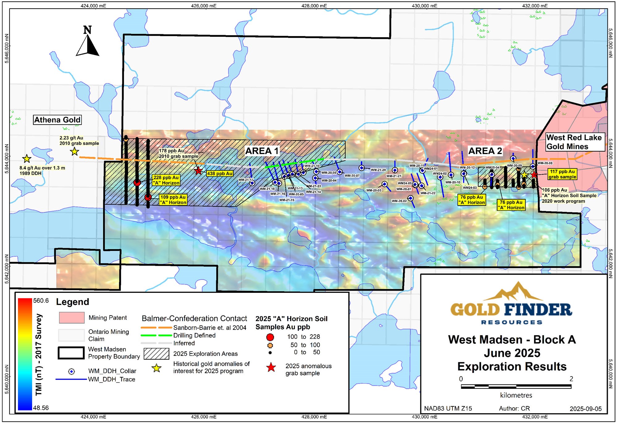
Figure 1: Showing West Madsen Block A with the 2025 target areas and analytical results.
To view an enhanced version of this graphic, please visit:
https://goldfinderresources.com/images/westmadsen/West_Madsen_Block_A_2025_Results.jpg
Emerald Geological Services (EGS) completed a prospecting and soil sampling program in June, targeting two areas on Block A near the western and eastern claim boundaries. A total of 25 rock (grab) samples and 218 "A" horizon soil samples were collected.
Area 1 Results
Area 1 spans up to 4 kilometers (km) from Tack Lake, where the Balmer-Confederation contact has been identified in drilling, to the western Block A boundary with Athena Gold's ("Athena") Laird Lake property, where Athena recently reported a bonanza-grade grab sample of 373 g/t Au (see Athena's news release of December 4, 2024) and the identification of new gold-in-till anomalies (see Athena's news release of September 4, 2025).
Three north-south lines of "A" horizon soil sampling were completed near the western Block A boundary, each 1.2 km long and spaced 200 meters apart with 25-meter sample station spacing. These lines were designed to test the Balmer-Confederation contact area and extend south into the Confederation Assemblage across linear magnetic features. The highest result was 228 ppb Au on the south side of the valley west of Tack Lake, which may represent the same gold-bearing structure that is present in the lake. The next highest result was 109 ppb Au further south in the vicinity of a linear magnetic high (see Figure 1 and Table 1).
Additionally, a historical sample near the west shore of Tack Lake was revisited. This sample consisted of syenitic rock with quartz veining in local float. A sample of the boulder returned 438 ppb Au, whereas the original sample reportedly returned 178 ppb Au according to the Ontario Assessment File Database (see Figure 1 and Table 2). The gold-bearing veinlets in this location might be explained as a peripheral offshoot of a geological structure underlying the valley west of Tack Lake.
Table 1: Top "A" horizon soil sampling results from 2025 field program
| Table 1 | June 2025 Top "A" Horizon Sample Results | |||||
| Sample | Area | Datum_Grid | Easting | Northing | Elev (m) | Au ppb (INAA) |
| F820006 | A Block East Line 1 | NAD83 UTM Z15 | 431050 | 5643440 | 418 | 76 |
| F820011 | A Block East Line 2 | NAD83 UTM Z15 | 431176 | 5643680 | 435 | 53 |
| F820024 | A Block East Line 3 | NAD83 UTM Z15 | 431279 | 5643480 | 429 | 76 |
| F820061 | A Block East Line 7 | NAD83 UTM Z15 | 431759 | 5643491 | 454 | 57 |
| F820064 | A Block East Line 6 | NAD83 UTM Z15 | 431664 | 5643438 | 444 | 63 |
| F820077 | A Block East Line 6 | NAD83 UTM Z15 | 431665 | 5643764 | 436 | 70 |
| F820099 | A Block West Line 2 | NAD83 UTM Z15 | 424752 | 5643520 | 438 | 228 |
| F820176 | A Block West Line 1 | NAD83 UTM Z15 | 424549 | 5644301 | 404 | 72 |
| F820202 | A Block West Line 3 | NAD83 UTM Z15 | 424950 | 5643251 | 434 | 109 |
Area 2 Results
Area 2 spans approximately 1 km near the eastern Block A boundary, where 2020 soil sampling yielded anomalies up to 106 ppb Au from "A" horizon, and where 2024 drillholes WM-24-03 and WM-24-04 intersected ultramafic flows believed to belong to the Balmer Assemblage, which hosts the majority of the current and past producing gold mines of the Red Lake Gold Camp (see Gold Finder's news release of November 7, 2024). The two highest "A" horizon soil anomalies in this area were both 76 ppb Au (see Figure 1 and Table 1), in the vicinity of where hole WM-23-04 was drilled, which returned 0.42 g/t Au and 0.94% Cu over 1 meter in ultramafic rocks (see above linked news release).
A sample of mafic volcanic outcrop with minor to moderate sugary grey quartz stringers, located 50 meters from the eastern Block A boundary, returned 117 ppb Au (see Figure 1 and Table 2), in the vicinity of anomalous soil samples from the 2020 field program.
Table 2: Top rock results from 2025 field program
| Table 2 | June 2025 Top Grab Sample Results | ||||||||
| Sample | Area | Easting | Northing | Elev (m) | Datum | Rock Type | Source | Description | Au ppb (FA-AA) |
| F820315 | Block A East | 431937 | 5643661 | 452 | NAD83 UTM Z15 | Mafic Volcanic | Outcrop | Mafic volcanic with minor to moderate greyish sugary quartz stringers, chlorite and potassic alteration, minor pyrite and chalcopyrite. | 117 |
| F820324 | Block A West | 425853 | 5643748 | 412 | NAD83 UTM Z15 | Syenite | Float | Syenite with 1-2cm quartz-kspar veinlet, 0.5% pyrite within vein, minor overall. Angular but likely local float. | 438 |
The program was successful in identifying target areas for follow-up exploration work. Results from the 2025 program, along with the 2024 drilling results in Area 2, suggest that the Balmer-Confederation contact may be located further south of where previously thought in these areas. This theory will be considered when planning future exploration programs.
QAQC
Soil and rock samples were collected, documented, and photographed in the field, then placed in sealed bags and delivered to Activation Laboratories (ActLabs) in Thunder Bay, an ISO / IEC 17025 accredited laboratory. Soil sample collection is subject to Emerald Geological Services' internal quality assurance / quality control (QAQC) protocols, which include the insertion of blank material and certified reference material into each batch of samples submitted. Rock samples referenced in this news release were analyzed using ActLabs methods 1A2-50, a 50g fire assay with atomic absorption finish, and 1F2, a total digestion with ICP-OES finish for trace elements. "A" horizon soil samples were analyzed using ActLabs methods 2A, an INAA analysis for gold and trace elements, as well as ActLabs method 2C1, an aqua regia partial digestion with ICP finish for select metals.
About the West Madsen Gold Project
The West Madsen Gold Project covers 5,988 hectares in the heart of the Red Lake Gold Camp. It comprises two contiguous claim blocks: Block A to the east and Block B to the west, both accessible by secondary roads connecting to Ontario HWY 618 then to the town of Red Lake 15 km to the northeast. Block A adjoins the Madsen Gold Mine property (Figure 2), owned by West Red Lake Gold Mines (WRLG), which announced the restart of production in June and reported the production of 3,800 ounces of gold in July (see WRLG news release of August 6, 2025).
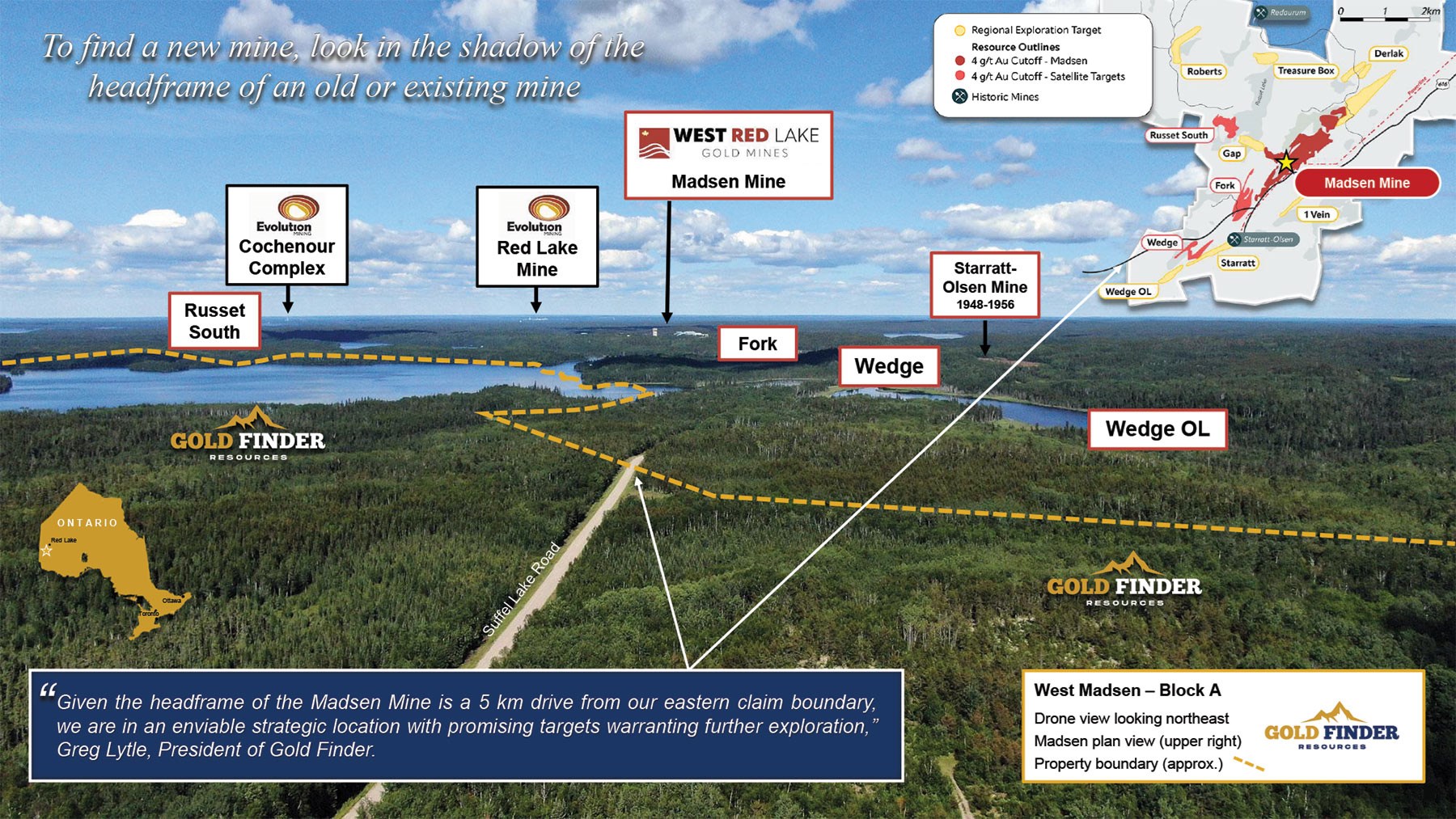
Figure 2: Drone view looking NE toward WRLG's Madsen Gold Mine/Mill Complex.
To view an enhanced version of this graphic, please visit:
https://goldfinderresources.com/images/westmadsen/WM-BLK-A_WRLG.jpg
The bulk of the mineral resources on the Madsen Mine property are hosted in a ~7-km-long gold trend that follows the major crustal break or contact between the Balmer and Confederation assemblages. Gold Finder has observed the same Balmer-Confederation contact in outcrop approximately 1.5 km west of the Block A eastern boundary and identified it within an ~8-km corridor of disrupted regional magnetics that traverses Block A from the Madsen Mine property.
Since acquiring the original claim blocks from Great Bear Resources in 2019 and additional claims from Bounty Gold in 2020 to increase the size of Block A, Gold Finder's exploration work, focused on Block A, has included geophysical interpretations, regional mapping and prospecting, rock sampling, a soil-gas-hydrocarbon survey, and approximately 11,100 metres of diamond drilling over 28 holes.
Diamond drilling has identified gold anomalies in both Balmer and Confederation Assemblage rocks. 2020 drilling intersected 14.4 g/t Au over 0.5 meters (m) in strongly altered Balmer mafic volcanic rocks (hole WM-20-05, see Gold Finder's news release of July 22, 2020), and 2021 drilling intersected 0.16 g/t Au over 195 m, including 0.51 g/t Au over 10.90 m from felsic intrusive rocks of the Confederation Assemblage (hole WM-21-22, see news release of June 1, 2021). Follow-up drilling to the latter intersection in 2024, 100 meters along strike to the southwest, intersected 0.28 g/t Au over 15 m from the felsic intrusive rocks and 0.85 g/t Au over 9.44 m from silicified metasediments in the hanging wall to the felsic intrusive rocks (hole WM-24-05, see Gold Finder's news release of November 7, 2024).
The technical information in this news release was reviewed and approved by Coleman Robertson, B.Sc., P. Geo., a qualified person (QP) for the purposes of NI 43-101 and V.P. Exploration for Emerald Geological Services.
About Gold Finder Resources Ltd.
Gold Finder is a mineral exploration company focused on discovery-stage properties. Our goal is to acquire a property through staking or option agreement, enhance the value by defining or redefining the exploration opportunity, and maintain ownership control during the potential high-value creation phase of discovery. We then source a well-financed partner capable of accelerating resource definition, and development. Although mineral exploration is inherently high-risk, it is during the discovery phase that the greatest shareholder wealth has historically been created in the resource sector.
For more information, you can visit our website at goldfinderresources.com, download our investor presentation, and follow us on X at https://x.com/GoldFinderRes.
ON BEHALF OF THE BOARD
Signed "Gregory Lytle"
Gregory Lytle, President
Gold Finder Resources Ltd.
Direct line: (604) 839-6946
Email: info@goldfinderresources.com
179 - 2945 Jacklin Road, Suite 416
Victoria, BC, V9B 6J9
Forward-Looking Statements
This news release may contain "forward-looking statements" that involve known and unknown risks, uncertainties, assumptions, and other factors that may cause the actual results, performance, or achievements of the Company to be materially different from any future results, performance or achievements expressed or implied by the forward-looking statements. Any forward-looking statement speaks only as of the date of this news release and, except as may be required by applicable securities laws, the Company disclaims any intent or obligation to update any forward-looking statement, whether as a result of new information, future events, or results or otherwise.
Neither TSX Venture Exchange nor its Regulation Services Provider (as that term is defined in the policies of the TSX Venture Exchange) accept responsibility for the adequacy or accuracy of this release.

To view the source version of this press release, please visit https://www.newsfilecorp.com/release/265622
Source: Gold Finder Resources Ltd.