Toronto, Ontario--(Newsfile Corp. - April 11, 2023) - Maritime Resources Corp. (TSXV: MAE) ("Maritime" or the "Company") is pleased to provide an update on exploration activity on the Whisker Valley and El Strato gold properties in the Baie Verte mining district of Newfoundland and Labrador. Maritime announces the discovery of a new high-grade gold prospect at the Whisker Valley project and has acquired an option on an additional mineral license, the 125 hectare, five-claim El Strato Property to consolidate a well-defined gold trend spanning 7 kilometres ("kms"). The El Strato gold mineralization is located proximal to the regionally significant Baie Verte Brompton Line (BVBL) and is a structurally controlled orogenic style that is comparable to the prolific gold rich Abitibi Archean greenstone belt of Central-Southern Quebec.
Highlights:
Maritime's exploration team has identified a large alkalic porphyry center and an accompanying alkalic epithermal system at the Fluorite Zone, located within the Whisker Valley property.
Initial drilling of the epithermal system encountered local anomalous fluorite, gold, silver, zinc, molybdenum, and lead values. The most significant results were obtained from hole FZ-21-08 which encountered 0.064% molybdenum over 9.0 m and 0.8 m of 2.65 grams per tonne ("gpt") gold, including 0.35 m of 6.27 gpt gold. See Figures 6 and Table 2.
Additional drilling 300 meters south of the Gary Vein Zone intersected significant mineralization including WH-21-34 returned 5.95 g/t gold over 0.48 m, WH-21-35 returned 7.57 g/t gold over 0.20 m, highlighting the potential for new vein discoveries in the area. See Figure 8 and Table 3.
Trenching of a chargeability anomaly near the Whisker Valley fault zone exposed a new polymetallic quartz/sulphide vein over 5.0 m with initial grab samples grading up to 8.54 gpt gold, 8.0 % lead, 24 gpt silver. See Figure 7, 8 and Table 1.
Maritime optioned additional claims on the El Strato gold trend further consolidating an emerging gold mineralized system stretching over 7 kms. New sampling by Maritime in 2022 of the El Strato Trend returned high grade gold values up to 21.83 gpt and 2.95 gpt gold in quartz/carbonate/sulphide veins verifying the high-grade tenor of the mineralized veins. See Figure 1, 2, 3 and Table 1.
The El Strato and Whisker Valley Structurally Controlled Gold Trends
The El Strato gold prospect hosts numerous gold and base metal occurrences and trends centered around the Whisker Valley and Middle Arm secondary fault structures which have extensive strike lengths approximately 7 kms (Figures 1 and 2). El Strato is centered along the major fault junction where the Middle Arm Fault intersects the BVBL. In this area previous exploration has identified widespread gold mineralization associated with secondary structures hosting quartz, carbonate and base-metal-rich veins considered to be indicative of a structurally controlled orogenic gold system. Historic grab samples of outcrop reported gold grades up to 239.6 gpt gold and angular float samples ranging from anomalous to 72.0 gpt gold (Figure 4). Limited historical drilling at the El Strato area has achieved intersections up to 3.15 gpt gold over 3.2m, and 14.23 gpt gold over 1.2 m (ES-11-23) - (News Release Cornerstone Capital Resources Inc, August 3, 2011). Soil sampling throughout the El Strato property has outlined several high-grade multi-station/multi-line gold anomalies in close proximity to the Middle Arm Fault. Three gold in-soil trends have been identified that are coincident with the historical drill intersections, high-grade gold in rock samples and untested IP chargeability anomalies. None of these results have been verified by Maritime and are considered historical, however representative sampling by Maritime staff in 2022 returned outcrop samples grading 21.83 gpt gold and 2.95 gpt gold at the Voodoo Brook showing which confirmed the high-grade nature of the mineralization (Figure 3).
The newly optioned mineral claims (White Option) are centrally located and cover a potential northeast extension of the El Strato mineralized trend (Figure 1, 2 and 4). Historical rock samples collected on the optioned property returned 3.3 gpt and 4.4 gpt gold in bedrock and 6.4 gpt, 11.1 gpt and 15.4 gpt gold in angular float. These samples coincide with an historical 3-kilometer-long in-soil gold anomaly (Figure 1). Trail access to the El Strato Property has been established and the Company has compiled historic geochemistry, geophysics and drillhole data and has reviewed historic drill cores and trenches on the property. This work will continue into the 2023 season with a focus on identifying and mapping the distribution and geometry of gold bearing structures to identify and test priority drill targets.

Figure 1. Whisker Valley and El Strato prospects - Compilation of gold in soil anomalies.
To view an enhanced version of this graphic, please visit:
https://images.newsfilecorp.com/files/4548/161907_5f87d14bd4e19bf0_001full.jpg

Figure 2. Whisker Valley and El Strato prospects - Compilation of gold in outcrop and float samples.
To view an enhanced version of this graphic, please visit:
https://images.newsfilecorp.com/files/4548/161907_5f87d14bd4e19bf0_002full.jpg

Figure 3. Representative samples collected from Voodoo Brook returned 21.83 gpt and 2.95 gpt gold.
To view an enhanced version of this graphic, please visit:
https://images.newsfilecorp.com/files/4548/161907_5f87d14bd4e19bf0_003full.jpg

Figure 4. Maritime 2022 rock samples and historical El Strato / White option soil sampling results > 25 ppb gold and significant rock sampling results for gold overlaid on Airborne Magnetics (TMI) base.
To view an enhanced version of this graphic, please visit:
https://images.newsfilecorp.com/files/4548/161907_5f87d14bd4e19bf0_004full.jpg
Whisker Valley Porphyry Target
Exploration work at Whisker Valley has identified a potential zone of porphyry monzodiorite stock consistent with intrusions associated with alkalic Cu-Au porphyry systems similar to the porphyry in Mount Polley, British Columbia (Figure 5). The alteration envelopes observed in the field and in drill core are typical of alteration encountered in these types of mineralized systems.
The related geophysical anomalies are broad and have multi-kilometre strike lengths and occur in a portion of the property that to date has received limited exploration work. Maritime plans to employ soil geochemistry, alteration vectoring by hyperspectral, as well as mapping to identify structural and magmatic controls on metal mineralization in order to identify economically significant portions of this large greenfield exploration target.

Figure 5. Strongly vesiculated and altered felspar porphyry monzodiorite with cavities filled with albite, calcite, epidote, magnetite and potassium feldspar.
To view an enhanced version of this graphic, please visit:
https://images.newsfilecorp.com/files/4548/161907_5f87d14bd4e19bf0_005full.jpg
Fluorite Zone Alkalic Epithermal Prospect
Maritime has identified a new mineralized corridor adjacent to the Whisker Valley Porphyry Trend. The newly discovered Fluorite Zone Prospect has been exposed in trenching 100 m and partially delineated using ground based induced polarization (IP) geophysics. Initial trenching and limited drilling have identified geology, alteration and mineralization consistent with that of an alkalic epithermal gold system similar to deposits of the Cripple Creek District in Colorado, USA which has produced 21 million ounces of gold. This first stage of exploration work included 9 drillholes and outlined a large diatreme breccia complex with widespread disseminated pyrite and localized occurrences of fluorite, sphalerite, molybdenum and rare earth elements. The rocks exhibit intense potassic and argillic alteration. The initial drilling encountered local anomalous gold, silver, molybdenum and lead values the most significant results were obtained from drill hole FZ-21-08 (Figure 6) which encountered 0.064% molybdenum over 9.0 m with three assays exceeding detection limits of 0.1% molybdenum, with overlimit analysis for these samples are still pending. In addition to molybdenum the hole intersected 0.8 m of 2.65 gpt gold, including 0.35 m of 6.27 gpt gold.

Figure 6. Fluorite Zone drill core FZ-21-08 depicting argillite and potassic alteration of rhyolite and diatreme breccias. A.) Fracture-controlled molybdenum. B.) Alteration zonation from pervasive argillic to potassic alteration with fluorite veining. C.) Argillic alteration with fluorite nodules. D.) Variably altered diatreme breccia.
To view an enhanced version of this graphic, please visit:
https://images.newsfilecorp.com/files/4548/161907_5f87d14bd4e19bf0_006full.jpg
Hyperspectral imaging was carried out on 1,000 m of drill core from the Fluorite Zone. This work was completed by Newfoundland's College of the North Atlantic (CONA) using state of the art VNIR-SWIR-MWIR-LWIR core scanning technology. Maritime would like to thank the National Research Council's Industrial Research Assistance Program (IRAP) for funding the project, as well as CONA researchers for their interpretation of the results. The hyperspectral test work identified rare earth element bearing minerals within later fractures as well as intervals of white mica alteration that correlated with pyrite mineralization in the core and concluded that hyperspectral imaging is a viable tool for defining alteration patterns and has the potential to vector towards mineralization in areas with complex alteration zones such as the Fluorite Zone. Maritime intends to complete hyperspectral scanning of the entire Fluorite Zone drill core to help in vectoring towards potential gold mineralization.
An IP geophysical survey carried out at the Fluorite Zone has identified a series of chargeability anomalies. Field checking from a chargeability anomaly on Line 2 identified a polymetallic quartz/sulphide vein in bedrock. This new vein at the FZ L2 IP anomaly has been partially exposed over 5 m and contained abundant galena, chalcopyrite, and sphalerite. Initial grab samples collected from outcrop at this newly discovered vein contained up to 8.54 gpt gold, 8.0 % lead, and 24 gpt silver. The vein mineralization is hosted in a narrow shear zone which returned 2.8 gpt gold from a grab sample (Figure 7).
Whisker Valley Area Drilling
An additional 17 drill holes were completed in the Whisker Valley area during the 2021 program to test various IP chargeability anomalies, known historical surface gold/base metal vein style mineralization, and interpreted structures. The IP anomalies were explained by intense disseminated pyrite and/or strongly pervasive magnetite/hematite alteration in the host granodiorite. Other holes that tested the sub-surface of known prospects intersected late brittle structures that appear to be off-setting the depth extension of mineralization. Four holes WH-21-34 to WH-21-37 were completed approximately 300 meters south of the Gary Vein zone (press release dated February 25, 2019) to test an interpreted structural trend. These holes intersected multiple quartz pyrite/base metal veins, which returned significant gold grades over narrow intersections. WH-21-34 returned 5.95 g/t gold over 0.48 m, 4.97 g/t gold over 0.40 m, WH-21-35 returned 7.57 g/t gold over 0.20 m, 1.28 g/t gold over 0.24 m, 0.56 g/t gold over 0.35 m and 1.85 g/t gold over 0.2 m. While WH-21-36 assayed 3.82 g/t gold over 0.2 m and WH-21-37 returned 0.92 g/t gold over 0.27 m, and 0.78 g/t gold over 0.20 m (see Figure 8 and Table 3). The intersections in the Gary Vein South area appear to be related to brittle secondary structures of the Whisker Valley Fault. The drilling highlighted the importance of structures in controlling the geometry of mineralized zones in the area. Further drilling will be based on modelling of the structures so that mineralized veins can be more accurately targeted for drilling.
The 2021 drilling campaign at the Whisker Valley Fluorite area was successful in determining the potential of a large porphyry/epithermal system near the contact with the Silurian King's Point Alkalic complex and the underlying Ordovician Burlington granodiorite. New drilling south of the Gary Vein system highlighted the potential for new vein discoveries. Future exploration in the area will entail modeling of known structures and mineralized veins along with geological mapping, mineralogy, and lithogeochemistry to determine the genetic aspects of mineralization in the Silurian Whisker Valley Cu-Au-Mo system.

Figure 7. Mineralized grab samples from newly discovered Fluorite Zone (FZ L2 IP Anomaly) prospect containing gold, silver, copper, lead and zinc. Images A. and B.) Quartz veining with gold, silver, copper, lead and zinc mineralization. C.) Mineralized shear zone adjacent to vein style mineralization.
To view an enhanced version of this graphic, please visit:
https://images.newsfilecorp.com/files/4548/161907_5f87d14bd4e19bf0_007full.jpg
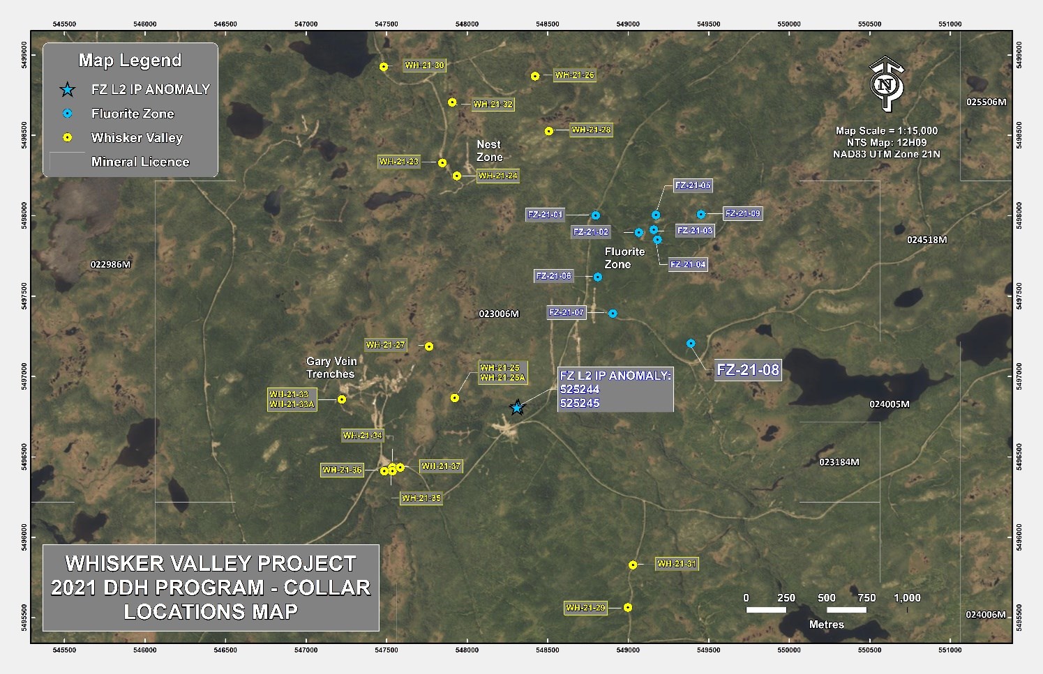
Figure 8. Location of 2021 diamond drilling at Whisker Valley
To view an enhanced version of this graphic, please visit:
https://images.newsfilecorp.com/files/4548/161907_5f87d14bd4e19bf0_008full.jpg
Table 1. Maritime 2022 rock sample locations and historical rock samples (NAD 83 Zone 21) along with assays.
| Sample | Project | Type | Easting | Northing | Au (g/t) | Ag (g/t) | Cu (%) | Pb (%) | Zn (%) | |
| 525244 | FZ L2 IP Anomaly | Bedrock Maritime | 548318 | 5496816 | 8.54 | 24.0 | 0.16 | 8.00 | 1.73 | |
| 525245 | FZ L2 IP Anomaly | Bedrock Maritime | 548309 | 5496808 | 2.82 | 0.4 | 0.01 | 0.06 | 0.02 | |
| 525146 | Voodoo Brook | Bedrock Maritime | 541665 | 5495702 | 21.83 | 100.6 | 0.17 | 7.20 | 1.13 | |
| 525150 | Voodoo Brook | Bedrock Maritime | 541706 | 5495691 | 2.95 | 13.2 | 0.01 | 1.11 | 0.28 | |
| 11875 | White Option | Bedrock Historical | 542975 | 5496284 | 4.37 | 1.0 | 0.05 | 0.09 | 0.04 | |
| 12089 | White Option | Bedrock Historical | 542410 | 5496283 | 3.23 | 1.0 | 0.1 | 0.24 | 0.61 | |
| 18009 | White Option | Float Historical | 543026 | 5496418 | 6.43 | N/A | N/A | N/A | N/A | |
| 18029 | White Option | Float Historical | 543199 | 5496758 | 11.07 | N/A | N/A | N/A | N/A | |
| 164958 | White Option | Float Historical | 542239 | 5496596 | 15.40 | N/A | N/A | N/A | N/A | |
| 11101 | El Strato | Bedrock Historical | 542670 | 5496170 | 35.45 | 33.60 | 0.00 | 0.01 | 0.00 | |
| 11110 | El Strato | Bedrock Historical | 546194 | 5500338 | 4.97 | 76.00 | 0.28 | 0.01 | 0.00 | |
| 12035 | El Strato | Bedrock Historical | 545948 | 5500177 | 1.50 | 27.70 | 0.75 | 0.00 | 0.01 | |
| 12043 | El Strato | Bedrock Historical | 544870 | 5499043 | 15.58 | 3.20 | 0.00 | 0.00 | 0.00 | |
| 26883 | El Strato | Bedrock Historical | 546351 | 5500509 | 1.29 | 16.10 | 0.06 | 0.00 | 0.00 | |
| 28157 | El Strato | Bedrock Historical | 542665 | 5495987 | 28.77 | 45.90 | 0.30 | 3.30 | 11.40 | |
| 33547 | El Strato | Bedrock Historical | 541762 | 5494654 | 61.69 | 30.70 | 0.07 | 2.04 | 0.17 | |
| 33553 | El Strato | Bedrock Historical | 542251 | 5495304 | 3.43 | 1.40 | 0.01 | 0.05 | 0.01 | |
| 33564 | El Strato | Bedrock Historical | 541317 | 5494910 | 6.83 | 2.70 | 0.02 | 0.66 | 0.31 | |
| 33569 | El Strato | Bedrock Historical | 542204 | 5495218 | 13.87 | 3.90 | 0.08 | 0.01 | 0.01 | |
| 33572 | El Strato | Bedrock Historical | 542296 | 5495186 | 20.32 | 12.30 | 0.07 | 1.47 | 0.21 | |
| 39717 | El Strato | Bedrock Historical | 542075 | 5494840 | 23.58 | 2.20 | 0.00 | 0.13 | 0.07 | |
| 39729 | El Strato | Bedrock Historical | 542148 | 5495036 | 5.15 | 0.20 | 0.00 | 0.00 | 0.00 | |
| 39767 | El Strato | Bedrock Historical | 541542 | 5495356 | 9.98 | 27.60 | 0.10 | 10.50 | 0.25 | |
| 39777 | El Strato | Bedrock Historical | 542236 | 5496121 | 4.15 | 21.50 | 0.05 | 0.00 | 0.31 | |
| 118539 | El Strato | Bedrock Historical | 545661 | 5499057 | 0.43 | 0.00 | 0.00 | 0.00 | 0.00 | |
| 118549 | El Strato | Bedrock Historical | 545766 | 5498985 | 0.40 | 0.00 | 0.00 | 0.00 | 0.00 | |
| 119759 | El Strato | Bedrock Historical | 545267 | 5499313 | 0.67 | 0.00 | 0.00 | 0.00 | 0.00 | |
| 120329 | El Strato | Bedrock Historical | 545193 | 5499408 | 0.70 | 0.00 | 0.00 | 0.00 | 0.00 | |
| 122679 | El Strato | Bedrock Historical | 541982 | 5495777 | 2.66 | 0.00 | 0.00 | 0.00 | 0.00 | |
| 122715 | El Strato | Bedrock Historical | 541636 | 5495166 | 1.14 | 4.70 | 0.04 | 2.54 | 2.66 | |
| 134553 | El Strato | Bedrock Historical | 541650 | 5495873 | 3.22 | 0.00 | 0.00 | 0.00 | 0.00 | |
| 164101 | El Strato | Bedrock Historical | 541686 | 5495806 | 10.52 | 0.00 | 0.00 | 0.00 | 0.00 | |
| 164128 | El Strato | Bedrock Historical | 541761 | 5495360 | 6.90 | 0.00 | 0.00 | 0.00 | 0.00 | |
| RML-98-12 | El Strato | Bedrock Historical | 541478 | 5494895 | 239.60 | 31.00 | 0.36 | 0.60 | 14.80 | |
| 999999 | El Strato | Bedrock Historical | 542979 | 5497625 | 59.60 | n/a | n/a | n/a | n/a | |
| 11108 | El Strato | Float Historical | 542751 | 5495707 | 22.66 | 77.70 | 0.15 | 0.00 | 0.00 | |
| 11303 | El Strato | Float Historical | 547345 | 5500834 | 0.86 | 1.30 | 0.01 | 0.00 | 0.00 | |
| 12763 | El Strato | Float Historical | 542784 | 5495852 | 54.32 | 119.90 | 0.92 | 0.00 | 0.00 | |
| 18011 | El Strato | Float Historical | 542662 | 5496123 | 62.01 | 0.00 | 0.00 | 0.00 | 0.00 | |
| 18155 | El Strato | Float Historical | 542626 | 5495917 | 67.10 | 0.00 | 0.00 | 0.00 | 0.00 | |
| 33608 | El Strato | Float Historical | 541746 | 5495169 | 53.26 | 47.90 | 0.69 | 6.90 | 9.60 | |
| 54584 | El Strato | Float Historical | 540926 | 5494640 | 1.42 | 0.20 | 0.00 | 0.00 | 0.00 | |
| 40003 | El Strato | Float Historical | 541833 | 5495808 | 57.79 | 15.70 | 0.01 | 1.84 | 0.05 | |
| 108445 | El Strato | Float Historical | 541854 | 5495359 | 13.61 | 0.00 | 0.00 | 0.00 | 0.00 | |
| 115438 | El Strato | Float Historical | 543011 | 5497489 | 59.60 | 0.00 | 0.00 | 0.00 | 0.00 | |
| 119210 | El Strato | Float Historical | 541677 | 5493752 | 2.87 | 0.00 | 0.00 | 0.00 | 0.00 | |
| 119219 | El Strato | Float Historical | 541777 | 5494182 | 70.90 | 0.00 | 0.00 | 0.00 | 0.00 | |
| 122601 | El Strato | Float Historical | 541570 | 5495689 | 67.00 | 0.54 | 0.08 | 3.24 | 1.61 | |
| 122636 | El Strato | Float Historical | 541916 | 5495768 | 72.00 | 19.54 | 0.04 | 2.61 | 0.84 | |
| 122727 | El Strato | Float Historical | 542036 | 5495081 | 10.70 | 12.30 | 0.06 | 2.26 | 0.08 | |
| 123018 | El Strato | Float Historical | 542663 | 5497240 | 16.10 | 0.00 | 0.00 | 0.00 | 0.00 | |
| 134560 | El Strato | Float Historical | 542052 | 5496025 | 14.80 | 0.00 | 0.00 | 0.00 | 0.00 | |
| 134583 | El Strato | Float Historical | 542140 | 5495907 | 105.30 | 0.00 | 0.22 | 14.00 | 7.10 | |
| 134590 | El Strato | Float Historical | 541922 | 5496345 | 51.00 | 0.00 | 0.00 | 0.00 | 0.00 | |
| 134594 | El Strato | Float Historical | 541767 | 5495750 | 11.50 | 92.56 | 0.06 | 0.57 | 0.99 | |
| 164910 | El Strato | Float Historical | 541868 | 5496240 | 72.00 | 0.00 | 0.00 | 0.00 | 0.00 | |
| 164957 | El Strato | Float Historical | 542015 | 5496375 | 26.90 | 0.00 | 0.01 | 0.41 | 0.04 | |
| 999998 | El Strato | Float Historical | 546445 | 5499329 | 1.50 | n/a | n/a | n/a | n/a | |
Table 2. Significant intersection FZ-21-08 Fluorite Zone.
| Hole ID | From (m) | To (m) | Length (m) | Mo% | Au g/t |
| FZ-21-08 | 58.00 | 67.00 | 9.00 | 0.064 | 0.02 |
| FZ-21-08 | 182.20 | 183.00 | 0.80 | 0.004 | 2.65 |
| Including | 182.65 | 183.00 | 0.35 | 0.001 | 6.27 |
Table 3. Significant intersection Gary Vein South Area.
| Hole | From | To | Length (m) | Au Composite (gpt) |
| WH-21-34 | 73 | 73.48 | 0.48 | 5.95 |
| WH-21-34 | 131.55 | 131.95 | 0.4 | 4.97 |
| WH-21-35 | 19.19 | 19.39 | 0.2 | 7.57 |
| WH-21-35 | 82.43 | 82.67 | 0.24 | 1.28 |
| WH-21-35 | 83.87 | 84.22 | 0.35 | 0.56 |
| WH-21-35 | 150.67 | 150.87 | 0.2 | 1.85 |
| WH-21-36 | 109.88 | 110.08 | 0.2 | 3.82 |
| WH-21-37 | 19.46 | 19.66 | 0.2 | 5.90 |
| WH-21-37 | 124.25 | 124.52 | 0.27 | 0.92 |
| WH-21-37 | 204.4 | 204.6 | 0.2 | 0.78 |
Table 4. Drill hole location
| Hole number | Azimuth | Inclination | Area | Depth (m) | Northing | Easting | Elevation |
| WH-21-25 | 19 | -51 | Whisker Valley | 31 | 5496871 | 547923 | 282 |
| WH-21-33 | 4 | -42 | Whisker Valley | 20 | 5496861 | 547219 | 322 |
| WH-21-33A | 6 | -42 | Whisker Valley | 151 | 5496861 | 547219 | 322 |
| WH-21-37 | 360 | -44 | Whisker Valley | 227 | 5496438 | 547586 | 278 |
| WH-21-36 | 360 | -46 | Whisker Valley | 145 | 5496420 | 547489 | 281 |
| WH-21-35 | 0 | -58 | Whisker Valley | 151 | 5496418 | 547538 | 278 |
| WH-21-34 | 0 | -46 | Whisker Valley | 146 | 5496440 | 547537 | 279 |
| WH-21-32 | 320 | -71 | Whisker Valley | 178 | 5498702 | 547911 | 296 |
| WH-21-31 | 179 | -45 | Whisker Valley | 115 | 5495912 | 549058 | 369 |
| WH-21-27 | 21 | -45 | Whisker Valley | 190 | 5497191 | 547756 | 293 |
| WH-21-30 | 11 | -46 | Whisker Valley | 100 | 5498929 | 547484 | 263 |
| WH-21-28 | 130 | -89 | Whisker Valley | 28 | 5498526 | 548509 | 340 |
| WH-21-29 | 57 | -89 | Whisker Valley | 125 | 5495559 | 548995 | 379 |
| WH-21-23 | 148 | -45 | Whisker Valley | 150 | 5498326 | 547853 | 288 |
| WH-21-26 | 0 | -90 | Whisker Valley | 107 | 5498870 | 548428 | 312 |
| WH-21-25A | 22 | -53 | Whisker Valley | 205 | 5496871 | 547923 | 282 |
| WH-21-24 | 311 | -47 | Whisker Valley | 184 | 5498261 | 547901 | 289 |
| FZ-21-09 | 266 | -45 | Fluorite Zone | 184 | 5498010 | 549462 | 387 |
| FZ-21-04 | 270 | -46 | Fluorite Zone | 172 | 5497853 | 549187 | 396 |
| FZ-21-08 | 233 | -46 | Fluorite Zone | 298 | 5497209 | 549388 | 373 |
| FZ-21-07 | 215 | -79 | Fluorite Zone | 161 | 5497389 | 548906 | 346 |
| FZ-21-06 | 231 | -46 | Fluorite Zone | 328 | 5497620 | 548816 | 352 |
| FZ-21-05 | 271 | -47 | Fluorite Zone | 193 | 5498006 | 549172 | 409 |
| FZ-21-03 | 270 | -46 | Fluorite Zone | 192 | 5497922 | 549162 | 405 |
| FZ-21-02 | 89 | -45 | Fluorite Zone | 211 | 5497903 | 549068 | 392 |
| FZ-21-01 | 270 | -46 | Fluorite Zone | 241 | 5498005 | 548802 | 360 |
Analytical Procedures:
All samples collected by Maritime assayed and pertaining to this press release were completed by Eastern Analytical Limited ("EAL") located at Springdale, Newfoundland, and Labrador. EAL is an ISO 17025:2005 accredited laboratory for a defined scope of procedures. EAL has no relationship to Maritime. Samples are delivered in sealed plastic bags to EAL by Maritime field crews where they are dried, crushed, and pulped. Samples are crushed to approximately 80% passing a minus 10 mesh and split using a riffle splitter to approximately 250 grams. A ring mill is used to pulverize the sample split to 95% passing a minus 150 mesh. Sample rejects are securely stored at the EAL site for future reference. A 30-gram representative sample is selected for analysis from the 250 grams after which EAL applies a fire assay fusion followed by acid digestion and analysis by atomic absorption for gold analysis. Other metals were analyzed by applying an acid digestion and 34 element ICP analysis finish. EAL runs a comprehensive QA/QC program of standards, duplicates, and blanks within each sample stream.
Qualified Person
Exploration activities at the Hammerdown Gold Project are administered on site by the Company's Exploration Manager, Larry Pilgrim, P.Geo. In accordance with National Instrument 43-101 Standards of Disclosure for Mineral Projects, Larry Pilgrim, P.Geo. Exploration Manager, is the Qualified Person for the Company and has prepared, validated and approved the technical and scientific content of this news release. The Company strictly adheres to CIM Best Practices Guidelines in conducting, documenting, and reporting its exploration activities on its exploration projects.
About Maritime Resources Corp.
Maritime holds a 100% interest- directly and subject to option agreements entitling it to earn 100% ownership- in the Green Bay/Whisker Valley/El Strato Properties. This includes the former Hammerdown gold mine and the Orion gold project plus the Whisker Valley exploration project, all located in the Baie Verte Mining District near the town of King's Point, Newfoundland, and Labrador. The Hammerdown Gold Project is characterized by near-vertical, narrow mesothermal quartz veins containing gold associated with pyrite. Hammerdown was last operated by Richmont Mines between 2000 and 2004. The Company also owns the gold circuit at the Nugget Pond metallurgical facility in Newfoundland and Labrador, the Lac Pelletier gold project in Rouyn Noranda, Québec and a number of other exploration properties in key mining camps across Canada.
On Behalf of the Board:
Garett Macdonald, MBA, P.Eng.
President and CEO
1900-110 Yonge Street, Toronto, ON M5C 1T4
Phone: (416) 365-5321
info@maritimegold.com
www.maritimeresourcescorp.com
Twitter
Facebook
LinkedIn
Youtube
Caution Regarding Forward Looking Statements:
Certain of the statements made and information contained herein is "forward-looking information" within the meaning of National Instrument 51-102 - Continuous Disclosure Obligations. Forward-looking statements are often identified by terms such as "will", "may", "should", "anticipate", "expects", "intends", "indicates" "plans" and similar expressions. Forward-looking statements include statements concerning the low capital intensity and rapid payback of the Project, the exploration upside relating to the Project, the pursuit of mine life extensions, the potential to increase mineral resource and mineral reserve estimates, returns and FCF relating to the Project, capital financing processes relating to the Project, development of the next drill program on the Project, exploration and development of the Orion deposit, "Run of Mine" ore scheduled to be mined from the Project, timing of submission of the Project Development Plan and the Progressive Rehabilitation and Closure Plan for Hammerdown, timing of future site construction, timing to first gold production, length of construction period for the Project, timing of completion of required permitting, timing for approvals to be obtained for the closure and development plans relating to the Project, availability of capital financing, the non-equity portion of any construction capital financing, timing of completion of construction capital financing process, amongst other things, which involve known and unknown risks, uncertainties and other factors which may cause the actual results, performance or achievements of the Company, or industry results, to be materially different from any future results, performance or achievements expressed or implied by such forward-looking information. All forward-looking statements and forward-looking information are based on reasonable assumptions that have been made by the Company in good faith as at the date of such information. Such assumptions include, without limitation, the price of and anticipated costs of recovery of, base metal concentrates, gold and silver, the presence of and continuity of such minerals at modeled grades and values, the capacities of various machinery and equipment, the use of ore sorting technology will produce positive results, the availability of personnel, machinery and equipment at estimated prices, mineral recovery rates, and others. Forward-looking information is subject to a variety of risks and uncertainties which could cause actual events or results to differ from those reflected in the forward-looking information, including, without limitation, the ability of the Company to continue to be able to access the capital markets for the funding necessary to acquire, maintain and advance exploration properties or business opportunities; global financial conditions, including market reaction to the coronavirus outbreak; competition within the industry to acquire properties of merit or new business opportunities, and competition from other companies possessing greater technical and financial resources; difficulties in advancing towards a development decision at Hammerdown and executing exploration programs at its Newfoundland and Labrador properties on the Company's proposed schedules and within its cost estimates, whether due to weather conditions, availability or interruption of power supply, mechanical equipment performance problems, natural disasters or pandemics in the areas where it operates; increasingly stringent environmental regulations and other permitting restrictions or maintaining title or other factors related to exploring of its properties, such as the availability of essential supplies and services; factors beyond the capacity of the Company to anticipate and control, such as the marketability of mineral products produced from the Company's properties; uncertainty as to whether the acquisition of assets and new mineral property interests including the Nugget Pond gold circuit will be completed in the manner currently contemplated by the parties; uncertainty as to whether mineral resources will ever be converted into mineral reserves once economic considerations are applied; uncertainty as to whether inferred mineral resources will be converted to the measured and indicated categories through further drilling, or into mineral reserves, once economic considerations are applied; government regulations relating to health, safety and the environment, and the scale and scope of royalties and taxes on production; and the availability of experienced contractors and professional staff to perform work in a competitive environment and the resulting adverse impact on costs and performance and other risks and uncertainties, including those described in each MD&A of financial condition and results of operations. In addition, forward-looking information is based on various assumptions including, without limitation, assumptions associated with exploration results and costs and the availability of materials and skilled labour. Should one or more of these risks and uncertainties materialize, or should underlying assumptions prove incorrect, actual results may vary materially from those described in forward-looking statements. Accordingly, readers are advised not to place undue reliance on forward-looking information. Except as required under applicable securities legislation, Maritime undertakes no obligation to publicly update or revise forward-looking information, whether as a result of new information, future events or otherwise.
Neither TSX Venture Exchange ("TSX-V") nor its Regulation Services Provider (as that term is defined in the policies of the TSX-V) accepts responsibility for the adequacy or accuracy of this release.
![]()
To view the source version of this press release, please visit https://www.newsfilecorp.com/release/161907
Source: Maritime Resources Corp.