Edmonton, Alberta--(Newsfile Corp. - February 22, 2023) - Grizzly Discoveries Inc. (TSXV: GZD) (FSE: G6H) (OTCQB: GZDIF) ("Grizzly" or the "Company") is pleased to announce that it has received assay results from rock sampling at the historical Imperial Mine approximately 5 km north of the community of Rock Creek, British Columbia (BC) within the west-central portion of the Company's Greenwood Precious - Battery Metal Project in south-central BC. The historical Imperial Mine is hosted in Late Paleozoic Anarchist volcanic and sedimentary rocks with mineralization consisting of pyrite-galena-sphalerite in quartz veins and pods associated with north and northwest trending faults related to the eastern edge of the Rock Creek Graben and the western edge of the Toroda Graben.
Highlights
- A total of 83 new selective rock grab and composite rock grab samples collected from a number of outcrops across the 815 hectare (2,015 acre) Imperial Mine target area.
- A total of 10 of the 83 rock grab samples from outcropping mineralization yielding a range from 193 grams per tonne (g/t) silver (Ag) up to 1,810 g/t Ag (or 5.63 ounces per ton [opt] up to 52.8 opt Ag) and 1.41 g/t Au up to 11.05 g/t Au (Table 1, Figures 1 and 2).
- The 10 new selective high-grade Ag-Au bearing rock grab samples from the historical Imperial Mine area were collected from five discreet areas of mineralization in and around the historical mine workings including from outcrop and underground as in Table 1 and Figures 1 and 2.
- All highly anomalous samples are characterized by the presence of abundant and visible pyrite, galena and sphalerite in quartz veins and/or pods of silicified metavolcanic or metasedimentary rocks (Greenstones). The mineralization can be described as polymetallic veins and altered wall rock that display the presence of silver, gold, lead, zinc and minor copper and it is likely metasomatic in nature. Granodiorite and diorite intrusions have been noted nearby.
- High levels of chromium and nickel reflect the presence of altered ultramafic rocks with serpentine-carbonate alteration and commonly identified as listwanite (Figure 3).
- The Imperial showings, including the veins and pods of mineralization in the underground, line up north-south to northwest-southeast and are potentially associated with a thrust fault that is broken and somewhat lined up along a north trending structure near the eastern edge of the Rock Creek Graben or the western edge of the Toroda Graben.
- The grabens are characterized by north-northeast trending normal faults (Figures 1 and 2).
- The geological setting and style of mineralization at the Imperial Mine bears a strong resemblance to the setting at the Historical Midway Mine about 13.5 km to the southeast.
- The Company is planning surface and underground rock and soil sampling, mapping, ground geophysical surveys and eventually drilling.
Table 1: Selected geochemical highlights for 24 rock grab samples* collected from the Imperial Mine area.
| Sample ID | Showing | Au g/t | Au opt | Ag g/t | Ag opt | Cu ppm | Pb ppm | Pb% | Zn ppm | Zn% | As ppm | Sb ppm | Ni ppm | Cr ppm |
| 22CCP275 | Imperial | 1.505 | 0.044 | 193 | 5.63 | 61 | 4,560 | 0.456 | 6,890 | 0.689 | 4,160 | 105 | 560 | 2,260 |
| 22CCP276 | Imperial | 4.16 | 0.121 | 257 | 7.50 | 177 | 10,500 | 1.050 | 15,000 | 1.500 | >10,000 | 201 | 341 | 697 |
| 22CCP277 | Imperial | 5.29 | 0.154 | 503 | 14.67 | 231 | 19,700 | 1.970 | 8,990 | 0.899 | 6,850 | 376 | 125 | 680 |
| 22CCP278 | Imperial | 7.32 | 0.214 | 479 | 13.97 | 206 | 8,960 | 0.896 | 8,160 | 0.816 | >10,000 | 264 | 85 | 420 |
| 22CCP279 | Imperial | 1.41 | 0.041 | 364 | 10.62 | 1045 | 42,700 | 4.270 | 73,800 | 7.380 | 2,430 | 67 | 658 | 1,700 |
| 22CCP280 | Imperial | 0.018 | 0.001 | 2.3 | 0.07 | 21 | 123 | 0.012 | 259 | 0.026 | 53 | <5 | 34 | 63 |
| 22CCP281 | Imperial | 0.002 | 0.000 | 0.7 | 0.02 | 93 | 57 | 0.006 | 172 | 0.017 | 25 | <5 | 41 | 50 |
| 22CCP292 | Imperial | 0.022 | 0.001 | 4 | 0.12 | 99 | 44 | 0.004 | 58 | 0.006 | 40 | 14 | 27 | 24 |
| 22CCP293 | Imperial | 0.006 | 0.000 | 3.8 | 0.11 | 44 | 41 | 0.004 | 118 | 0.012 | 37 | 6 | 121 | 153 |
| 22SLP224 | Imperial | 0.026 | 0.001 | <0.5 | <0.01 | 37 | 20 | 0.002 | 247 | 0.025 | 26 | <5 | 22 | 78 |
| 22SLP225 | Imperial | 0.01 | 0.000 | 0.5 | 0.01 | 42 | 10 | 0.001 | 253 | 0.025 | 13 | <5 | 33 | 24 |
| 22SLP226 | Imperial | 0.053 | 0.002 | <0.5 | <0.01 | 128 | 20 | 0.002 | 186 | 0.019 | 56 | <5 | 14 | 52 |
| 22SLP227 | Imperial | 4.21 | 0.123 | 1670 | 48.71 | 569 | 15,650 | 1.565 | 39,400 | 3.940 | 7,640 | 707 | 457 | 1,215 |
| 22SLP228 | Imperial | 11.05 | 0.322 | 1810 | 52.79 | 494 | 21,500 | 2.150 | 29,100 | 2.910 | >10,000 | 868 | 364 | 776 |
| 22SLP229 | Imperial | 4.53 | 0.132 | 269 | 7.85 | 171 | 5,310 | 0.531 | 7,510 | 0.751 | 7,010 | 86 | 234 | 908 |
| 22SLP230 | Imperial | 0.02 | 0.001 | 3.8 | 0.11 | 28 | 44 | 0.004 | 201 | 0.020 | 446 | 9 | 531 | 1,325 |
| 22SLP231 | Imperial | 10.55 | 0.308 | 637 | 18.58 | 498 | 16,450 | 1.645 | 46,100 | 4.610 | >10,000 | 147 | 354 | 654 |
| 22SLP232 | Imperial | 6.96 | 0.203 | 477 | 13.91 | 400 | 13,200 | 1.320 | 36,700 | 3.670 | >10,000 | 304 | 483 | 1,100 |
| 22SLP233 | Imperial | 0.008 | 0.000 | 1.8 | 0.05 | 44 | 43 | 0.004 | 170 | 0.017 | 36 | <5 | 34 | 64 |
| 22SLP234 | Imperial | 0.006 | 0.000 | 0.8 | 0.02 | 540 | 13 | 0.001 | 120 | 0.012 | 8 | <5 | 68 | 43 |
| 22SLP235 | Imperial | 0.004 | 0.000 | 0.6 | 0.02 | 140 | 9 | 0.001 | 96 | 0.010 | 5 | <5 | 66 | 82 |
| 22SLP263 | Imperial | 0.023 | 0.001 | <0.5 | <0.01 | 17 | 6 | 0.001 | 34 | 0.003 | 9 | <5 | 6 | 30 |
| 22SLP336 | Imperial | 0.051 | 0.001 | 4 | 0.12 | 22 | 56 | 0.006 | 413 | 0.041 | 314 | 6 | 138 | 529 |
| 22SLP337 | Imperial | 0.004 | 0.000 | 1 | 0.03 | 6 | 11 | 0.001 | 43 | 0.004 | 59 | 6 | 266 | 693 |
*Selective rock grab samples are illustrative of the tenor of mineralization for the material collected but may or may not be characteristic of the overall mineralization of the zone sampled as they are selective in nature.
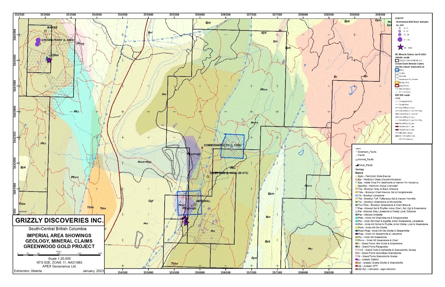
Figure 1: Imperial area silver in recent rock geochemistry and geology.
To view an enhanced version of this graphic, please visit:
https://images.newsfilecorp.com/files/4488/155713_407017c24472a995_003full.jpg

Figure 2: Imperial area gold in recent rock geochemistry and geology.
To view an enhanced version of this graphic, please visit:
https://images.newsfilecorp.com/files/4488/155713_407017c24472a995_004full.jpg
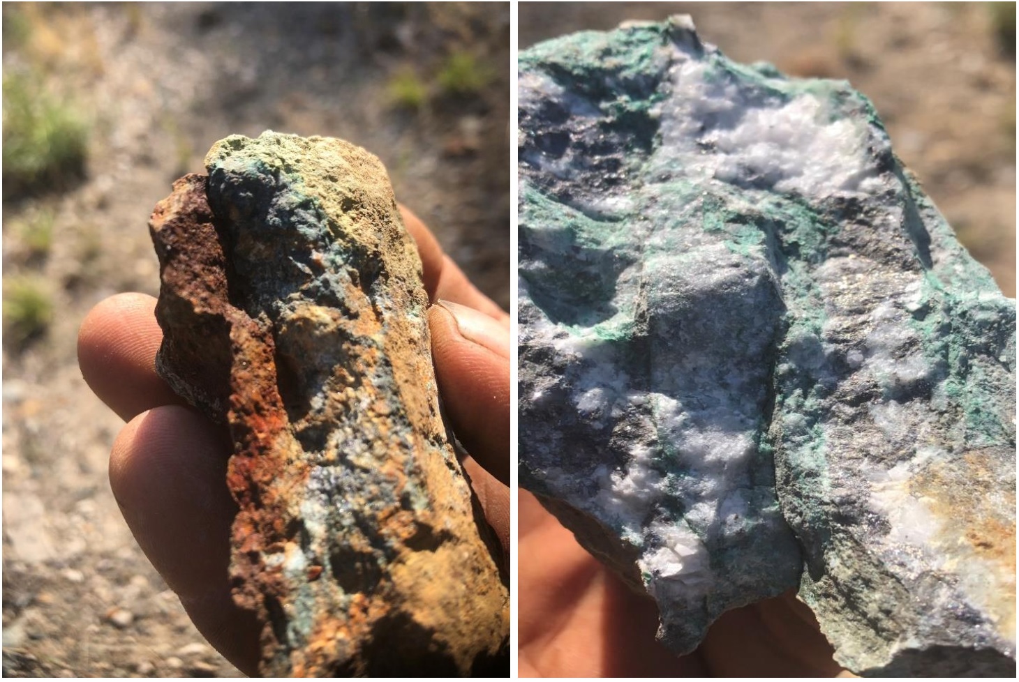
Figure 3: Imperial area listwanite alteration and sulphide mineralization.
To view an enhanced version of this graphic, please visit:
https://images.newsfilecorp.com/files/4488/155713_grizzlyfigure3.jpg
Brian Testo, President and CEO of Grizzly Discoveries, stated, "I am extremely happy with the first ever results from our existing Imperial Mine lands and we are anxiously anticipating the 2023 work program including drilling as we move the Imperial, Midway and other targets forward this year. We will be well-positioned for the upcoming exploration season and for potential new discoveries within all of our precious metals and battery metals properties."
Background for the Historical Imperial Mine
Discovery of the Imperial area mineralization dates back to the late 1890's with initial production first recorded in the early 1900's. The historical Imperial Mine has seen intermittent production from the early 1900's to as recently as 2011. According to the BC Government minfile records the historical Imperial Mine produced a little over 9,200 oz of silver and more than 20,000 pounds each of lead and zinc. The production records cover the period from 1914 to 1949 (BC MINFILE 082ESE113). Details of the total production during the 1990's through to the 2000's by the Cannon family is unknown. Open pit and underground mining were conducted during the period.
The historical Imperial Mine, is located on the eastern margin of the Kettle River, is underlain by a complex north-trending graben that exposes Paleozoic metasedimentary and metavolcanic rocks, which were later intruded by Jurassic diorite and granodiorite suites. Extension in the hanging wall terrane on the western margin of the Grand Forks complex led the formation of north-trending grabens and later, to favourable mineralization in the area. In the Eocene, alkalic intrusives, namely megacrystic granites and the Coryell intrusive suite and Eocene and younger coarse sediments and alkalic volcanic rocks filled these grabens. This led to localization of both base- and precious-metal deposits in the area (Höy, 2016).
At the Imperial Mine, the property is bounded to the north and south by the Nelson intrusions, consisting of granodiorite, porphyritic granite and diorite. In some locations, these cut the ultramafic rocks. The east is bordered by the Phoenix Volcanic Group of andesite and basalts. The west is predominantly drift covered in the vicinity of the property (Larabie, 1987). As exposed in the underground workings, mineralization is hosted in magnesium-iron rich carbonitized and silicified ultramafics along with sheared and sericitic greenstones and metasediments of the Upper Paleozoic Anarchist and Knob Hill Groups (BC MINFILE 082ESE113). In the early days of exploration, the mineralized rock was described as altered dolomitic sediment associated with abundant quartz and calcite, which had been altered by a green-coloured mineral, most likely chlorite and/or chromium mica or listwanite (Sloan, 1926).
The economic minerals of interest are mainly galena, sphalerite, and pyrite, all of which contain gold and silver. Mineralization occurs primarily in the carbonates as pods or lenses, and lesser as quartz sulphide veins and banded sulphides. These sulphides are confined to narrow quartz veins (0.3 - 1.0 m wide), along with some thicker pods which vary in dip from 20° to 80°. Precious-metal grades vary considerably throughout the underground workings as shown by assay maps from various exploration activities (e.g., 1925 and 1984) (Larabie, 1987).
Some gold occurs with the silver in the sulphides, along with pyrite and arsenopyrite but gold is also known to occur in a steep set of fractures with quartz veining that cuts orthogonally across the more flat-lying banded sulphide pods. The gold content increases as the fractures trend toward a Eocene Coryell intrusive, a couple of km to the east of the open pit.
The Imperial Mine target area is 815 ha (2,015 acres) and includes the Riverside Past Producer and Commonwealth showing north of the Imperial Mine. At Riverside, underground workings show that Ag-Pb-Zn+/-Au mineralization is also hosted in the metasedimentary rocks of the Upper Palaeozoic Anarchist and Knob Hill Groups. Polymetallic (Ag-Pb-Zn+/-Au) mineralization occurs in veins and along shears. The historical mine produced nearly as much silver as the Imperial Mine (BC MINFILE 082ESE114). At the Commonwealth showing, about 500 m northeast of the Riverside Past Producer, mineralization consists of pyrite, galena, sphalerite, and mariposite within 0.20 to 2 m wide quartz veins. These vein systems can be divided into two sets: one that strikes north-easterly and dips to the south, and the second, which also strikes north-easterly, but dips flatly to the southeast (BC MINFILE 082ESE115).
Limited Intermittent exploration, including some trenching, diamond drilling and small open pit mining has been conducted over the last 50 years in particular at the historical Imperial Mine. The Company plans to conduct reconnaissance exploration leading to more detailed exploration including additional surface sampling, ground geophysics, potentially underground sampling and eventually drilling and at the Imperial Target area during the upcoming 2023 field season.
Assaying was conducted at ALS Global in Vancouver with each sample analyzed for gold by a standard fire assay (Au-ICP-21), which involved the fusion of a 30 g sample aliquot and a wet chemical (ICP) finish. "Overlimit" Au-ICP21 results (>10 g/t Au) were followed up with Au-GRA21 analysis. This involved a 30 g fire assay fusion and gravimetric finish. Additionally, each sample was submitted for multi-element geochemical analysis by the ME-MS61 technique, which is an ICP-MS analysis following a near-total, four-acid, digestion of a 0.25 g sample aliquot. Initial silver and base metal (Cu, Pb and Zn) "overlimit" ICP-MS results (>100 g/t Ag and >1% for base metals) were analyzed by a follow-up, "ore grade" ICP technique (OG62), which also involved ICP analysis following a four-acid digestion on a 0.4 g sample aliquot. Any samples with silver values by OG62 >1,500 g/T were re-analyzed by 30 g fire assay with a gravimetric finish (Ag-GRA21). ALS Minerals has developed and implemented strategically designed processes and a global quality management system at each of its locations that meets all requirements of International Standards ISO/IEC 17025:2017 and ISO 9001:2015.
The technical content of this news release and the Company's technical disclosure has been reviewed and approved by Michael B. Dufresne, M. Sc., P. Geol., P.Geo., who is the Qualified Person as defined by National Instrument 43-101 Standards of Disclosure for Mineral Projects.
ABOUT GRIZZLY DISCOVERIES INC.
Grizzly is a diversified Canadian mineral exploration company with its primary listing on the TSX Venture Exchange focused on developing its approximately 66,000 ha (approximately 165,000 acres) of precious and base metals properties in southeastern British Columbia. Grizzly is run by highly experienced junior resource sector management team, who have a track record of advancing exploration projects from early exploration stage through to feasibility stage.
On behalf of the Board,
GRIZZLY DISCOVERIES INC.
Brian Testo, CEO, President
Suite 363-9768 170 Street NW
Edmonton, Alberta T5T 5L4
For further information, please visit our website at www.grizzlydiscoveries.com or contact:
Nancy Massicotte
Corporate Development
Tel: 604-507-3377
Email: nancy@grizzlydiscoveries.com
Neither the TSX Venture Exchange nor its Regulation Services Provider (as that term is defined in the policies of the TSX Venture Exchange) accepts responsibility for the adequacy or accuracy of this release.
Caution concerning forward-looking information
This press release contains "forward-looking information" and "forward-looking statements" within the meaning of applicable securities laws. This information and statements address future activities, events, plans, developments and projections. All statements, other than statements of historical fact, constitute forward-looking statements or forward-looking information. Such forward-looking information and statements are frequently identified by words such as "may," "will," "should," "anticipate," "plan," "expect," "believe," "estimate," "intend" and similar terminology, and reflect assumptions, estimates, opinions and analysis made by management of Grizzly in light of its experience, current conditions, expectations of future developments and other factors which it believes to be reasonable and relevant. Forward-looking information and statements involve known and unknown risks and uncertainties that may cause Grizzly's actual results, performance and achievements to differ materially from those expressed or implied by the forward-looking information and statements and accordingly, undue reliance should not be placed thereon.
Risks and uncertainties that may cause actual results to vary include but are not limited to the availability of financing; fluctuations in commodity prices; changes to and compliance with applicable laws and regulations, including environmental laws and obtaining requisite permits; political, economic and other risks; as well as other risks and uncertainties which are more fully described in our annual and quarterly Management's Discussion and Analysis and in other filings made by us with Canadian securities regulatory authorities and available at www.sedar.com. Grizzly disclaims any obligation to update or revise any forward-looking information or statements except as may be required by law.
![]()
To view the source version of this press release, please visit https://www.newsfilecorp.com/release/155713
Source: Grizzly Discoveries Inc.