Vancouver, British Columbia--(Newsfile Corp. - December 15, 2021) - Gelum Resources Corp. (CSE: GMR) ("Gelum" or the "Company") reports that all results have been received for the geochemical sampling programme carried out in September this year on the Eldorado Gold Property, located within the Bralorne-Bridge River Gold District in south-central British Columbia. The results confirm and significantly expand some of the historical gold anomalies generated by previous workers.
The Eldorado Gold Property is located 22 kilometres north of the Bralorne mine, and 17 kilometres North of the community of Gold Bridge (Figure 1). The 9028-hectare property covers multiple Minfile listings and two past-producing, small-scale gold mines that form the northern extent of the Bridge River-Bralorne/Pioneer orogenic gold system. Gold occurs in polymetallic sulphide veins and vein stockworks within broad quartz-carbonate alteration in the Eldorado granodiorite stock and surrounding rocks. These units are complexly juxtaposed along numerous faults associated with regional-scale structures linked to gold mineralization in the region. For detailed maps and project photos, please download the presentations at https://www.gelumcapital.com.
Sampling Details
Gelum collected 62 continuous chip rock samples over several exploration targets, and 485 soil samples from lines over the extensive serpentinite & listwanite alteration west of the Northern Lights and Lucky Strike workings. Additional ridge crest soil lines were completed north of Lucky Jem, on the north-facing slope at the headwaters of Nea Creek (historically sluiced for gold), and both sides of Nea Peak filling gaps in historical soil grids.
The Northern Lights soil and rock gold anomaly is currently considered a first-order drill target (Figure 1). Gelum's soil grid extended the gold soil anomaly an additional 500 metres to the south of a grid completed by Gold Fields in 2011. Peak soil values occur between the two Northern Lights adits, with a maximum value of 2.76 g/t Au; some of this mineralization may be dispersal from historical workings in the area. The source of the gold appears to be extensive listwanite (iron carbonate) alteration within volcanic, sedimentary, and ultramafic rocks below a gently east-dipping sill of Eldorado pluton diorite. Above this sill and structurally under a gabbro unit there is a 10-15m thick, east-dipping iron carbonate, which was rock sampled in detail and had the highest, most consistent antimony values of the programme, associated with gold up to 0.214 g/t. The northern extent of this layer at depth is another target (Taylor).
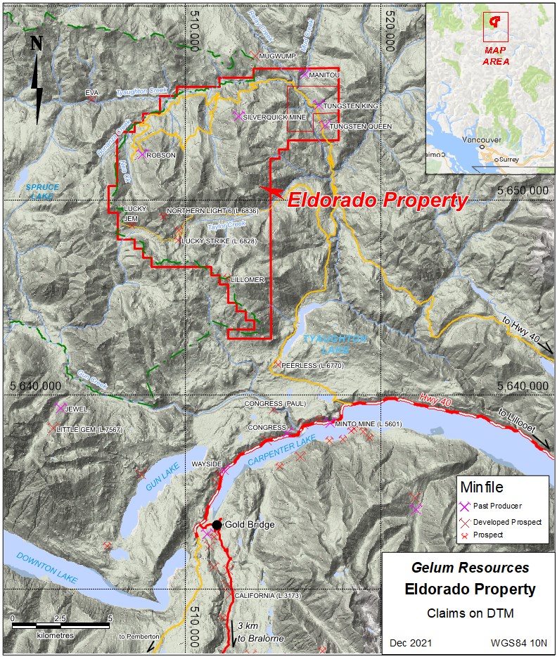
Figure 1. Location and access of the Eldorado property.
To view an enhanced version of Figure 1, please visit:
https://orders.newsfilecorp.com/files/6458/107659_4e2c0b8824cb8929_002full.jpg

Figure 2. Gridded Gold in Soil - Northern Lights area
To view an enhanced version of Figure 2, please visit:
https://orders.newsfilecorp.com/files/6458/107659_4e2c0b8824cb8929_003full.jpg
The rock sampling also focused on the extensive rock exposure in the north-facing cliff below Nea Peak, where east-dipping, closely spaced, 1-3m thick iron carbonate veins cut the Eldorado diorite. These units have variable gold values (many in the 0.1-0.2 g/t over 1-2m, the highest at 1.4 g/t over 3m), but more consistent arsenic and antimony values, which are pathfinder elements in the Bralorne area.
Sampling and Assay Procedures; Quality Control and Quality Assurance
Rock chips were collected by chip sampling outcrops across the structural grain in a continuous line, between 0.5m to 3m long; a single grab sample was collected from a prospect pit. Handheld GPS coordinates and digital photos were taken at each sample site and used to verify to the extent possible the assay results, sample locations and general geology. Four field duplicates were collected (about 1 in 20).
Soil samples were collected in grid at 50m interval along 100m spaced lines running SW to NE using a hand-held GPS for positional control. Several other 50m spaced samples were collected along ridges and spurs where thick talus made a grid impractical; one line runs parallel to the elevation contour in talus beneath inaccessible outcrops below Nea Peak. For quality assurance and control, duplicates and field blanks were inserted every 30 samples. No errors or anomalous results were noted.
Sample bags were stored in rice sacks, secured with zip ties, and delivered to MSA Labs in Langley, B.C. Rocks and soils received the same treatment: dry, crush 1 kg to 2mm, split 250g and pulverized to 85% passing 75 microns (code PRP-910). 34 elements were analyzed using the ICP-230 package, which includes 4-acid digestion of a 0.25g sample and ICP-ES finish. Gold was done by method FAS-111, in which a 30g sample is fire-assayed and finished with atomic absorption (AA) and, if overlimit, gravimetric.
Readers are cautioned that surface sampling results reported here should be viewed primarily as a guidance for future exploration drilling. Surface sampling is prone to sampling bias and is not necessarily a reliable indicator of mineralization at depth. The qualified person for this release has not done sufficient work to independently verify the historical sampling results shown in Figure 2, but Gelum does consider them current and indicative of future results because they were collected and reviewed by a qualified person.
Qualified Person
John Drobe, P.Geo., a qualified person as defined by NI 43-101, has reviewed the scientific and technical information that forms the basis for this news release and has approved the disclosure herein. Mr. Drobe is not independent of the Company as he is a consultant of the Company.
About Gelum Resources Corp.
Gelum Resources is a company led by seasoned management in the mining and financial sectors. The Company's objective is the discovery of a multi-million oz. economic gold deposit in the Bralorne-Bridge River gold district located some 190 kilometers north of Vancouver and 74 km northwest of the town of Lillooet, B.C. This objective is made possible through the Company's acquisition of 26 mineral claims with a total area of 9028 hectares located in the Bralorne-Bridge River Gold District, which was host to one of the highest-grade, longest-producing mines in British Columbia. Management is proud to have developed an excellent working relationship with the Bridge River Indian Band (Xwísten) who, after thorough site investigation of our prime targets, confirm that they currently have no heritage or cultural concerns with the current workplan to date.
For further information please refer to Gelum Resources Corporate Presentation:
https://gelumresources.com/pdf/Gelum-Resources-Deck-Fall-2021.pdf
On Behalf of the Board of Directors
David Smith, President
For further information about Gelum, please contact:
David Smith, President
(dsmith@gelumresources.com)
Phone: 604 484-1228
Cell : 778-834-1141
Neither the CSE nor its Regulation Services Provider (as that term is defined in the policies of the CSE- Canadian Securities Exchange) accepts responsibility for the adequacy or accuracy of this release.
Cautionary Statements Regarding Forward Looking Information
This presentation contains forward-looking statements and forward-looking information (collectively, "forward-looking statements") within the meaning of applicable Canadian and US securities legislation. All statements, other than statements of historical fact, included herein including, without limitation, statements regarding any potential increase in shareholder value through the acquisition of undervalued precious metal deposits for development, joint venture or later disposition, the potential to partner with mine developers to achieve production at any of the Company's properties (existing or future); the potential for the capital costs associated with any of the Company's existing or future properties to be low; the potential for the Company to outline resources at any of its existing or future properties, or to be able to increase any such resources in the future; concerning the economic outlook for the mining industry and the Company's expectations regarding metal prices and production and the appropriate time to acquire precious metal projects, the liquidity and capital resources and planned expenditures by the Company, the anticipated content, commencement, timing and cost of exploration programs, anticipated exploration program results and the anticipated business plans and timing of future activities of the Company, are forward looking statements. Forward-looking statements are based on a number of assumptions which may prove incorrect, including, but not limited to, assumptions about the level and volatility of the price of gold; the timing of the receipt of regulatory and governmental approvals; permits and authorizations necessary to implement and carry on the Company's planned exploration programs at its properties; future economic and market conditions; the Company's ability to attract and retain key staff; and the ongoing relations of the Company with its underlying lessors, local communities and applicable regulatory agencies.
Accordingly, the Company cautions that any forward-looking statements are not guarantees of future results or performance, and that actual results may differ, and such differences may be material, from those set out in the forward-looking statements as a result of, among other factors, variations in the nature, quality and quantity of any mineral deposits that may be located, the Company's inability to obtain any necessary permits, consents or authorizations required for its activities, material adverse changes in economic and market conditions, changes in the regulatory environment and other government actions, fluctuations in commodity prices and exchange rates, the inability of the Company to raise the necessary capital for its ongoing operations, and business and operational risks normal in the mineral exploration, development and mining industries, as well as the risks and uncertainties disclosed in the Company's most recent management discussion and analysis filed with various provincial securities commissions in Canada, available at www.sedar.com. The Company undertakes no obligation to update publicly or release any revisions to these forward-looking statements to reflect events or circumstances after the date of this presentation or to reflect the occurrence of unanticipated events except as required by law. All subsequent written or oral forward-looking statements attributable to the Company or any person acting on its behalf are qualified by the cautionary statements herein.
To view the source version of this press release, please visit https://www.newsfilecorp.com/release/107659
Source: Gelum Resources Ltd.