Vancouver, British Columbia--(Newsfile Corp. - October 30, 2017) - Forum Uranium Corp. (TSXV: FDC) ("Forum" or the "Company") announces the successful completion of a horizontal loop electromagnetic (HLEM) survey on its 100% owned Fir Island project, located along the north rim of Saskatchewan's Athabasca Basin. Geophysical modeling of the data collected demonstrates evidence of structural disruption and faulting in the island area of the East Channel, confirming that this unique area has significant potential for discovering uranium mineralization. Targets here will be prioritized for further drilling. In addition, the survey results have elevated the overall exploration potential of the East Channel, which hosts a series of ground gravity lows with associated strong boron anomalies (>3,000 ppm B) in the soils. Planning for follow-up exploration is underway.
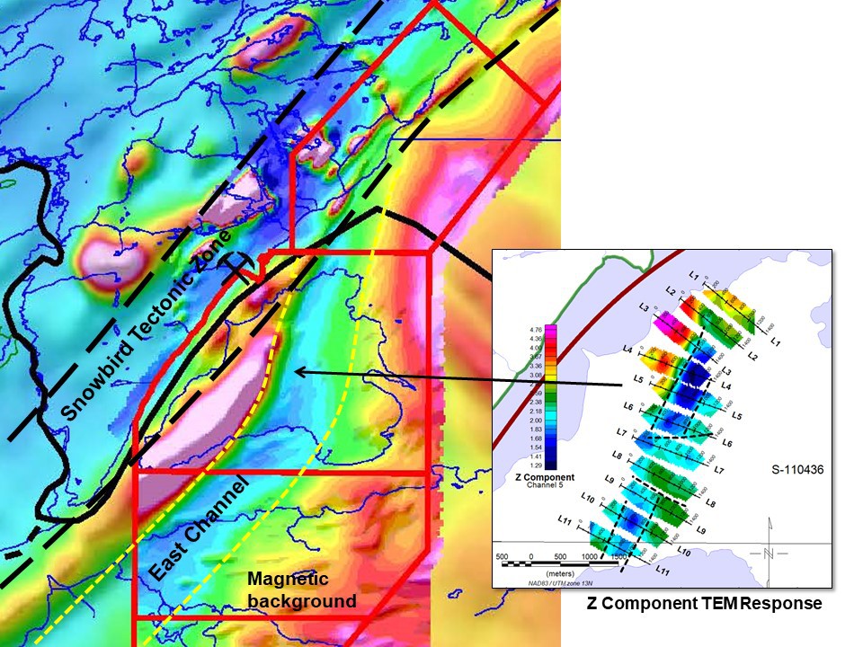
This survey targeted the property's East Channel (Figure 1), a 50km long structure marked by strong magnetic and gravity lows on the east side of a magnetic high, most notably where it bends into the crustal scale feature of the Snowbird Tectonic Zone (Figure 2), present on the west side of the project. Line-cutting was completed by the Black Lake First Nations and the geophysics by Patterson Geophysics Inc. based in La Ronge.
Ken Wheatley, P.Geo., Forum's Vice-President, Exploration is the Qualified Person that has reviewed and approved the contents of this news release.
About Forum Uranium
Forum Uranium Corp. is a Canadian-based mineral exploration company focusing on the acquisition, exploration and development of Canadian uranium projects. Forum has assembled a highly experienced team of exploration professionals with a track record of mine discoveries for unconformity-style uranium deposits in Canada. The Company has a strategy to discover near surface uranium deposits in the Athabasca Basin, Saskatchewan by exploring on its 100% owned properties and through strategic partnerships and joint ventures with Cameco, AREVA, Rio Tinto Exploration, NexGen and Uracan.
ON BEHALF OF THE BOARD OF DIRECTORS
Richard J. Mazur, P. Geo.
President & CEO
Neither the TSX Venture Exchange nor its Regulation Services Provider (as that term is defined in the policies of the TSX Venture Exchange) accepts responsibility for the adequacy or accuracy of this release.
For further information contact:
Rick Mazur, President & CEO
Tel: 604-630-1585
Craig Christy, VP Corporate Development
Tel: 250-863-0561

Figure 1: Fir Island Project with Magnetic Background. The red to pink is the mag high, the blues are mag lows. The East Channel lies on the east - southeast side of a very strong mag high, probably an Archean granite. The survey was completed on the island section of the East Channel — modeling of the results show structural disruption within the East Channel, in conjunction with a series of gravity lows and corresponding boron anomalies in soil samples. The thick black line shows the limit of the Athabasca sandstone; the thickness of the sandstone varies from 0 to 250m on this project.
To view an enhanced version of Figure 1, please visit:
http://orders.newsfilecorp.com/files/4908/30031_a1509229455999_25.jpg

Figure 2: Location and Geology Map of the Fir Island Project. An all-weather road is present within 3km of the property and connects with the McClean Lake and Rabbit Lake uranium mills.
To view an enhanced version of Figure 2, please visit:
http://orders.newsfilecorp.com/files/4908/30031_a1509229456202_34.jpg
Source: Forum Energy Metals Corp.