
Vancouver, British Columbia--(Newsfile Corp. - September 28, 2026) - Gold Hunter Resources Inc. (CSE: HUNT) (OTCQB: HNTRF) (WKN: A2QPAL) ("Gold Hunter" or the "Company") reports that its 2026 drill program at the Great Northern Project, Newfoundland has concluded with 2,879 metres drilled in 13 holes across six target areas, against a planned program of up to 10,000 metres. Winterization and demobilization have been recently completed.
Highlights
2,879 metres drilled in 13 holes across six target areas: Kramer, the Thor and Viking trend intersection, Simms Ridge, Incinerator, Viking North and Viking.
The program was planned at up to 10,000 metres and concluded when expenditures reached the program budget. Drilling costs per metre were substantially higher than the estimates based on changes to program scope.
Drilling at the Thor Deposit was deferred to 2027 due to unanticipated safety issues with the bridge on the access road and pending permits for the repair of the bridge.
Samples from all 13 holes have been submitted to ALS. Results will be released once received and reviewed and interpreted by the Company's Qualified Person.
Clarifying Previous Disclosure Regarding the Drill Program
In addition, the Company wishes to clarify certain disclosure contained in its news releases dated February 2, 2026, March 18, 2026, April 21, 2026, May 6, 2026, June 4, 2026, and June 25, 2026 (the "Previous Disclosure") as well as the letters to shareholders issued on May 1, 2026 ("Dispatch 1") and on September 3, 2026 ("Dispatch 2", and together with Dispatch 1, the "Dispatch").
The Company would like to clarify the following statements in the Previous Disclosure and Dispatch:
Funding. The Previous Disclosure and Dispatch stated that Gold Hunter was fully funded for the planned drill program from start to finish, and referred to a program of up to 10,000 metres and to the sufficiency of the Company's funding to complete it. The Company wishes to clarify that it was funded to a fixed program budget that it anticipated would cover up to 10,000 metres. However, drilling costs per metre substantially exceeded the estimates on which the program was planned, resulting in a smaller drill program than originally anticipated. Drilling concluded on September 4, 2026 at 2,879 metres. Moreover, the Previous Disclosure stated that the Company completed a $6.7 million financing in connection with being fully funded for the drill program. The Company wishes to clarify that the amount budgeted for the drill program was approximately $3.8 million, including applicable taxes.
Drilling contractor. Dispatch 2 described MCL Drilling as providing the drill rig and crews. The Company wishes to clarify that in addition to MCL Drilling the Company also utilized Forage Fusion as the Company's drilling contractor, to provide the helicopter-supported drilling component of the program before Dispatch 2 was issued.
Permits. Dispatch 2 stated that the permits required for drilling were in place. The Company wishes to clarify that the permits required to commence drilling at the targets drilled in 2026 were in place. However, two permits relating to access to the Thor area, including permits to repair the bridge due to unanticipated safety concerns with the bridge on the access road, were outstanding as at the date of the Dispatch and remain outstanding as of the date of this news release.
Dispatch 1 and Dispatch 2 have been removed from the Company's website.
Sean Kingsley, President and CEO of Gold Hunter, commented:
"We planned up to 10,000 metres and drilled 2,879, at a cost per metre well above the estimate the program was built on. What the program delivered is the first drill test of the Viking North trend, holes at Kramer, Simms Ridge and Incinerator, and 2,879 metres of core at the lab. Our mission at Great Northern has not changed: to test the gold-bearing splays along the Doucers Valley Fault systematically, one season at a time. I look forward to reporting the results as they come in."
Program Details
The drill program was designed around three pillars: regional exploration along the gold-bearing structural splays of the Doucers Valley Fault, which extend up to 10 kilometres from the main corridor on the property; on-trend drilling at the Thor Deposit and across the Viking Block; and verification drilling at Rattling Brook. The Thor Deposit hosts a mineral resource estimate of 879,000 tonnes Indicated at 1.79 g/t Au (51,000 ounces Au) and 67,000 tonnes Inferred at 1.97 g/t Au (4,200 ounces Au), as detailed in the NI 43-101 Technical Report and Mineral Resource Estimate for the Thor Deposit, Viking Project, White Bay Area, Newfoundland, with an effective date of October 24, 2023 and an effective date of July 12, 2024.
The drill program was planned on the assumption that most holes would be drilled from track-accessible sites at an all-in cost well below what the season delivered. With the change to the budget, bridge permits delayed and consideration for claim expenditure requirements, a larger share of the drilling than planned required helicopter support, the initial drilling contractor was replaced early in the season to meet equipment requirements. The resulting cost per metre significantly exceeded the planning estimate. Expenditures reached the program budget on September 4, 2026 and drilling concluded on that date.
Once on site, the team identified damage to a bridge on the access road to the Thor area, which damage was unanticipated and required that permits be obtained prior to accessing the Thor area using that bridge. The Company applied for the permits required to repair it, and the permits were not issued in time for the 2026 program. The Company elected to defer drilling at Thor rather than proceed by helicopter, in order to keep the cost per metre in that area lower. Once the permits are in place the repair can proceed and drilling at Thor can resume.
With Thor deferred, drilling focused on the regional targets. Three holes were drilled at Kramer, at the confluence of the Thor and Viking trends, and two holes tested the intersection between the north-south Thor trend and the northeast-trending Viking trend. The Kramer trend is a near-surface, open-ended, northeast-trending zone. Mineralization was discovered in 2009 when road construction exposed an approximately 30 metre wide zone of altered Precambrian granite carrying quartz-sulphide veins with fine visible gold; grab samples returned up to 49.8 g/t Au and 111.2 g/t Ag.1 Subsequent drilling defined mineralization as stockwork quartz veins, stringer veinlets and fracture fillings, comprising high-grade veins within lower-grade haloes with sulphides.2 Historical drill intercepts include 1.12 g/t Au over 20.05 metres from 53.50 metres (including 5.42 g/t Au over 3.25 metres from 60.05 metres) in KR-10-07 and 25.44 g/t Au over 0.50 metres from 19.70 metres in KR-13-17; true widths are unknown.23
Three holes were drilled at Simms Ridge, undercutting historical trenching with thick quartz veins mapped at surface. Several grab samples from the trenches contained strong mineralization, including sample 45710, which assayed 26.63 g/t Au.4
Two holes were drilled at the Incinerator trend, a 1.8 kilometre long, east-west (070 degree) trending zone of fault-controlled alteration and gold mineralization on the Jackson's Arm claim block. The trend is defined by an alteration corridor, a 1.0 kilometre long IP chargeability anomaly, a magnetic-low lineament, a topographic low marking the fault, and anomalous gold-in-soil values up to 700 ppb. Initial drilling in 1987 consisted of four broadly spaced (100 to 500 metre) diamond drill holes, all of which contained mineralized intervals: 2.32 g/t Au over 4.1 metres from 33.10 metres (RB-41), 1.06 g/t Au over 15.6 metres from 66.80 metres (RB-39), 1.00 g/t Au over 9.7 metres from 32.10 metres (RB-37) and 1.78 g/t Au over 4.0 metres from 47.20 metres (RB-35); true thicknesses are unknown.5
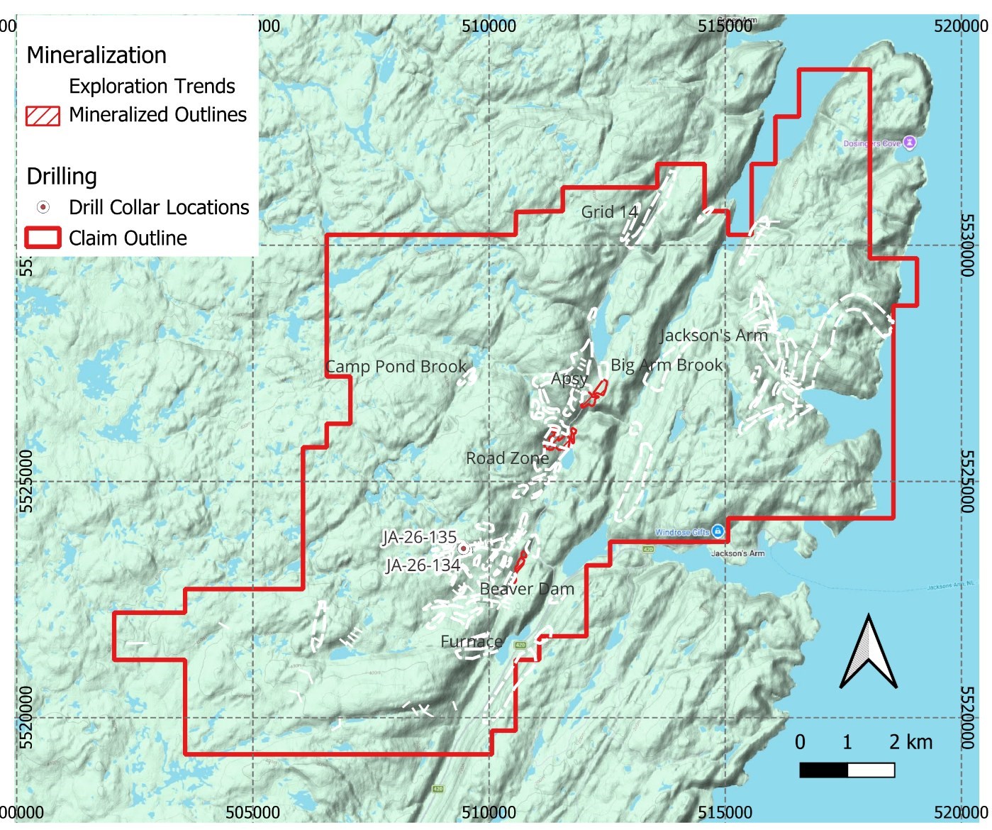
Figure 2: Drill locations, Jackson's Arm block
To view an enhanced version of this graphic, please visit:
https://images.newsfilecorp.com/files/8550/316478_1aa5c79f74d23bf4_001full.jpg
Drilling then moved to the Viking North trend, an 8.0 kilometre long, east-west (070 degree) striking fault zone running sub-parallel to and north of the Viking trend, on the Precambrian Long Range Inlier side of the Doucers Valley Fault. This fault splay hosts gold mineralization at the Viking, Incinerator and Furnace trends. In 2022, Magna Terra Minerals completed the first systematic coverage of the trend: 992 B-horizon soil samples on 100 metre lines at 25 metre spacing returned assays up to 203 ppb Au, with 15 samples above 50 ppb and 41 above 20 ppb, confirming a continuous 8 kilometre gold-in-soil anomaly coincident with the fault. The 2026 holes represent the first drill test of the structure. Assay results are pending.6
The Viking trend is a 6.4 kilometre long, northeast-trending zone of deformation, alteration and quartz-sulphide veining hosted in granodiorite augen gneiss, foliated monzogranite and deformed mafic rocks of the Long Range Inlier, west of the Doucers Valley Fault. The alteration zone reaches 40 to 80 metres in width and is interpreted as a moderately east-dipping reverse fault splaying into the Doucers Valley Fault. The Viking trend was the final target drilled in the 2026 program. Assay results are pending.
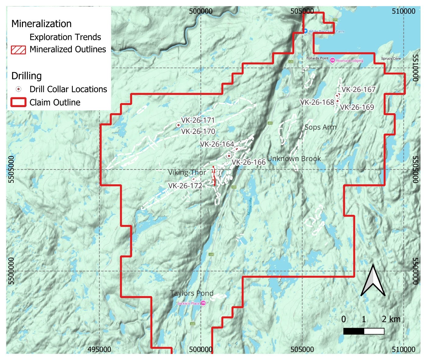
Figure 3: Drill locations, Viking block
To view an enhanced version of this graphic, please visit:
https://images.newsfilecorp.com/files/8550/316478_1aa5c79f74d23bf4_002full.jpg
Historical Data and Data Verification
The historical exploration results for the Kramer, Simms Ridge, Incinerator and Viking North trends referenced in this news release are derived from assessment reports filed with the Government of Newfoundland and Labrador and prior technical reports, as cited in the footnotes. The Company's Qualified Person has reviewed these sources but has not independently verified the historical sampling, analytical or drilling data, and the historical results have not been confirmed by the Company's 2026 program, for which assay results are pending. Grab samples are selective by nature and are not necessarily representative of the mineralization hosted on the property. Historical drill intercepts are reported as core lengths and true widths are unknown. Samples from the 2026 program were submitted to ALS Geochemistry Moncton, New Brunswick for gold assay analysis (Au-AA23) and Vancouver, British Columbia for 48 element ICP analysis (ME-MS61), and the Company's quality assurance and quality control program, including the insertion of certified reference materials, blanks and duplicates, will be described with the results.
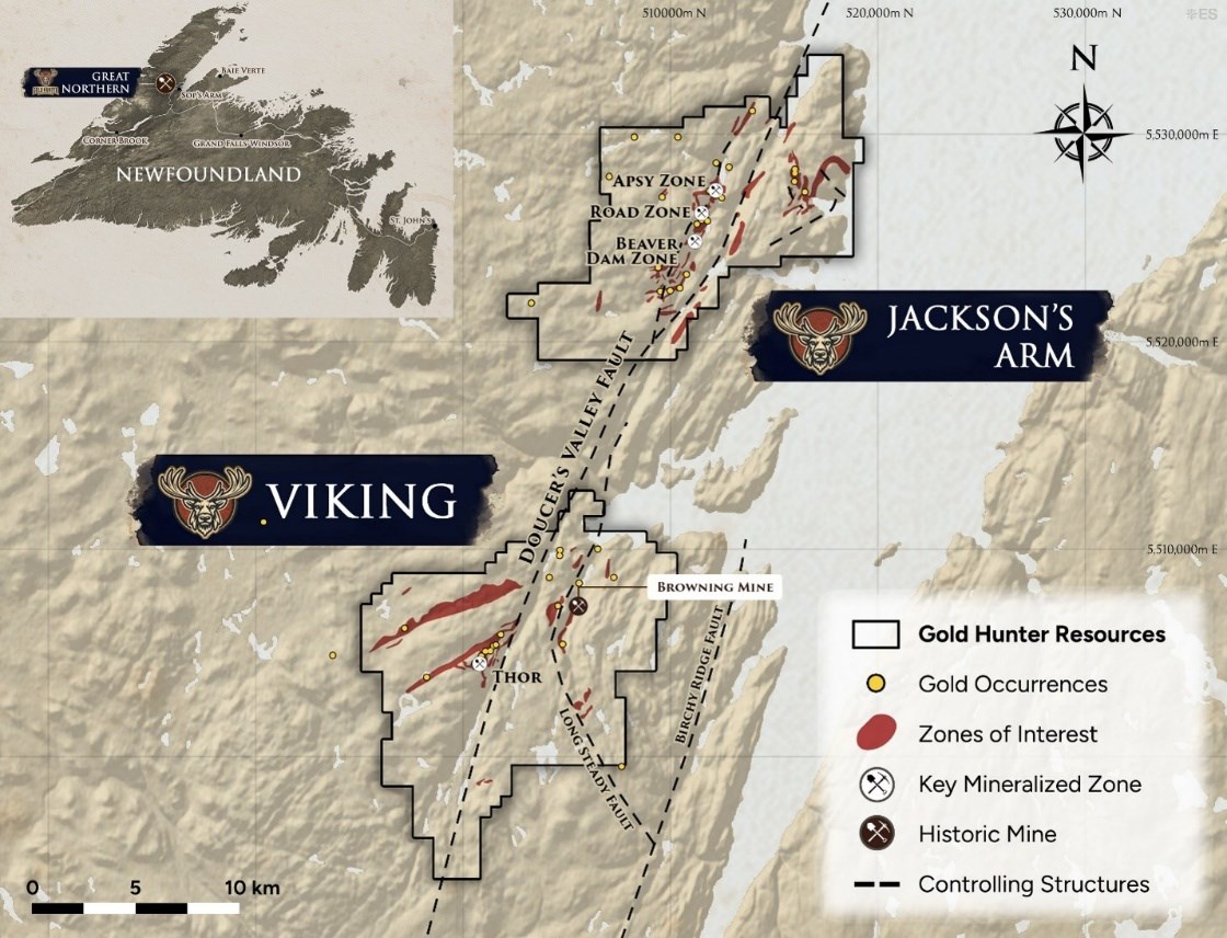
Figure 1: Overview location map of the Great Northern Project, White Bay, Newfoundland
To view an enhanced version of this graphic, please visit:
https://images.newsfilecorp.com/files/8550/316478_1aa5c79f74d23bf4_003full.jpg
Next Steps
Winterization and demobilization of the 2026 program, including reclamation of drill sites and access in accordance with permit conditions.
Release of assay results for all 13 holes once received and reviewed by the Qualified Person.
Integration of the 2026 data into the Company's targeting models for the property.
Planning of the 2027 program, including Thor once road access is re-established, subject to financing.
Qualified Person
The scientific and technical information contained in this news release has been reviewed and approved by Mr. Rory Kutluoglu, B.Sc., P.Geo., Vice President of Exploration for Gold Hunter Resources Inc. and a "Qualified Person" as defined under National Instrument 43-101 Standards of Disclosure for Mineral Projects ("NI 43-101"). Mr. Kutluoglu is a Professional Geologist registered with Engineers and Geoscientists British Columbia (EGBC) and a Fellow of both the Society of Economic Geologists and the Geological Society of London.
About Gold Hunter Resources Inc.
Gold Hunter Resources Inc. is a Canadian mineral exploration company focused on acquiring and advancing high-potential precious and base metal projects. The Company employs a data-driven approach to exploration, combining modern techniques with historical datasets to identify and develop district-scale opportunities.
Following the divestiture of its first consolidated district to FireFly Metals Ltd., Gold Hunter has assembled the Great Northern Project, covering 26,237 hectares and over 35 kilometres of strike length along the prospective Doucers Valley Fault structure in Newfoundland. Within the Doucers Valley Fault, over 50 kilometres of potential splays and secondary faults with known mineralization and potential for additional mineralization have been identified. The Company is committed to responsible exploration, meaningful stakeholder engagement, and delivering long-term value to shareholders.
On Behalf of the Board of Directors
GOLD HUNTER RESOURCES INC.
Sean A. Kingsley
President, Chief Executive Officer, and Director
Email: info@goldhunterresources.com
Phone: +1 604-440-8474
Website: www.goldhunterresources.com
Neither the CSE nor its Regulation Services Provider (as defined in the policies of the CSE) accepts responsibility for the adequacy or accuracy of this release.
Forward-Looking Statements
This news release contains "forward-looking information" and "forward-looking statements" (collectively, "forward-looking statements") within the meaning of applicable Canadian securities laws. These statements relate to future events or the Company's future performance and reflect current expectations or beliefs regarding future events, including but not limited to statements regarding the timing and receipt of assay results, the winterization, demobilization and reclamation of the 2026 program, the repair of the Thor access bridge and the issuance of related permits, the planning, timing, scope and financing of a 2027 drill program, and the potential of the Great Northern Project. Forward-looking statements are inherently subject to known and unknown risks, uncertainties, and assumptions that may cause actual results, performance, or achievements to differ materially from those expressed or implied. These risks and uncertainties include, but are not limited to, volatility in commodity prices, exploration and development risks, availability of financing, regulatory or political developments, the ability to retain qualified personnel and contractors, timely completion of drilling programs, drilling and other exploration costs exceeding estimates, and changes in project parameters as plans continue to be refined. No assurance can be given that any of the events anticipated by the forward-looking statements will occur or, if they do occur, what benefits the Company will obtain from them.
Although Gold Hunter believes the expectations expressed in such forward-looking statements are reasonable, such statements are not guarantees of future performance and actual results may differ materially. The Company does not undertake any obligation to update or revise any forward-looking statements, whether as a result of new information, future events, or otherwise, except as required by applicable law. Accordingly, readers should not place undue reliance on forward-looking statements.
1Froude, T 2010. Report of work on the Kramer property, White Bay area, Newfoundland: airborne survey, compilation on licence 15519M and supplementary report of work, prospecting, trenching and assaying on licence 12713M, NTS 12H/10. Assessment report prepared for Spruce Ridge Resources Ltd. Newfoundland and Labrador Geological Survey, Assessment File 12H/10/2043.
2Froude, T. 2011. Report on Diamond Drilling, Trenching and Prospecting Activites by Spruce Ridge Resources Limited on the Kreamer Property Area and adjacent Licences White Bay Area, Newfoundland Licences 12713M, 17095M and 17096M, NTS 12H/10 and 11, Newfoundland and Labrador Geological Survey, Assessment File 12H/10/2150.
3Froude, T. 2014. Seventh Year Report on Diamond Drilling Activities by Spruce Ridge Resources Limited on the Kramer Property, Western Newfoundland Licence 19689M NTS 12H/10 and 11 .
4Quinlan, L., 2012: First year assessment report on prospecting, rock and soil sampling carried out from January 2012 to August 2012 on the Sops Arm property, licences 019558M and 019756M, White Bay area, Newfoundland. Newfoundland and Labrador Geological Survey, Assessment File 12H/10/2198, 2012
5Harrington, M. and Collins, R., 2024: NI 43-101 Technical Report for Great Northern Project, White Bay Area, Newfoundland, Canada, Mineral Resource Estimate for the Thor Deposit. Prepared for Gold Hunter Resources Inc. by Mercator Geological Services Limited. Effective date July 12, 2024.
6Copeland and Barrett, 2022. Assessment Report on Soil Sampling and Prospecting on the Viking Project, Mineral Licences 19689M (Year 16) and 023770M (Year 7), White Bay, Newfoundland NTS 12H/10, 12H/11, 12H/15.

To view the source version of this press release, please visit https://www.newsfilecorp.com/release/316478
Source: Gold Hunter Resources Inc.