
Vancouver, British Columbia--(Newsfile Corp. - August 27, 2026) - Cabral Gold Inc. (TSXV: CBR) (OTCQX: CBGZF) ("Cabral" or the "Company") is pleased to announce results from ten additional diamond drill holes at the Jerimum Cima target located within the Cuiú Cuiú Gold District, Brazil.
Highlights
- Drilling at the Jerimum Cima target, located 3km ENE of the Central gold deposit and 3.5km NW of the MG gold deposit at Cuiú Cuiú, has returned 8.9m @ 5.8 g/t gold from 208.1m depth including 1.8m @ 28.4 g/t gold from 212.2m depth in hole DDH411
- The intercept in DDH411 is interpreted as a new mineralized zone which is located 200m south of the main mineralized zone at Jerimum Cima. This new zone appears to trend east-west, is parallel to the main zone, and is open to the east, west and at depth
- DDH393 was designed to test the down dip extension of the northern-most zone of mineralization at Jerimum Cima and returned 9.3m @ 2.78 g/t gold from 207.1m depth including 1.7m @ 7.2 g/t gold from 207.1m depth. The hole also intersected 10.2m @ 1.00 g/t gold from 225.0m depth
Alan Carter, Cabral's President and CEO commented, "The identification of a new mineralized zone at Jerimum Cima, located approximately 200m south of and running parallel to the main centrally located high-grade zone, is highly encouraging. This opens up the possibility of additional high-grade gold mineralization at the Jerimum Cima target which has already returned some spectacular drill results, including DDH385 which recently returned 9.5m @ 87.4 g/t gold. Further drilling will be required to determine the extent and along strike continuity of this new mineralized zone which remains open to the east, west and at depth."
Jerimum Cima Drill Results
The Jerimum Cima target is located 3 kilometres ("km") ENE of the Central gold deposit and 3.5km NW of the MG gold deposit (Figure 1). The target is characterized by a very strong gold-in-soil anomaly of +100 parts per billion ("ppb") gold covering an area of 900 meters ("m") x 1000m and is comparable with the gold-in-soil anomalies above the MG and Central gold deposits, and the PDM and Machichie Main gold discoveries. As with the MG gold deposit and the Machichie Main gold discovery, gold mineralization at Jerimum Cima is centered on a major east-west trending fault zone, which forms a splay off the regional scale Tocantinzinho fault system.
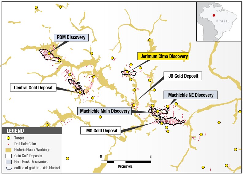
Figure 1: Map showing location of known gold deposits at Central, MG and JB. The location of discoveries at PDM, Machichie NE and Machichie Main as well as the Jerimum Cima discovery are also shown.
To view an enhanced version of this graphic, please visit:
https://images.newsfilecorp.com/files/3900/311672_689530e6a4324b8f_002full.jpg
Recent drilling at Jerimum Cima has returned some excellent results including:
- DDH372 with 9.5m @ 87.4 grammes per tonne ("g/t") gold from 173.8m depth including 2.9m @ 285.5 g/t gold (see press release dated March 12, 2026)
- DDH378 with 10.2m @ 8.7 g/t gold from 99.5m depth including 1.3m @ 62.5 g/t gold from 108.4m depth (see press release dated May 13, 2026)
- CC26 with 45.6m @ 4.5 g/t gold including 1.5m @ 117.26 g/t gold in primary intrusive rock material
- RC561 with 49m @ 2.0 g/t gold including 1m @ 57.0 g/t gold (see press release dated May 21, 2025) and
- DDH359 with 82.6m @ 1.0 g/t including 9.5m @ 5.74 g/t gold (see press release dated January 26, 2026)
- DDH384 with 107.6m @ 2.5 g/t gold from 162.7m depth including 17.8m @ 13.0 g/t gold (see press release dated June 2, 2026)
Results have been received on an additional ten diamond drill holes recently completed at Jerimum Cima. Most of these holes were drilled peripheral to the main high-grade mineralized zone and were designed to test the areas north, south and east of the main mineralized zone (Figure 2).
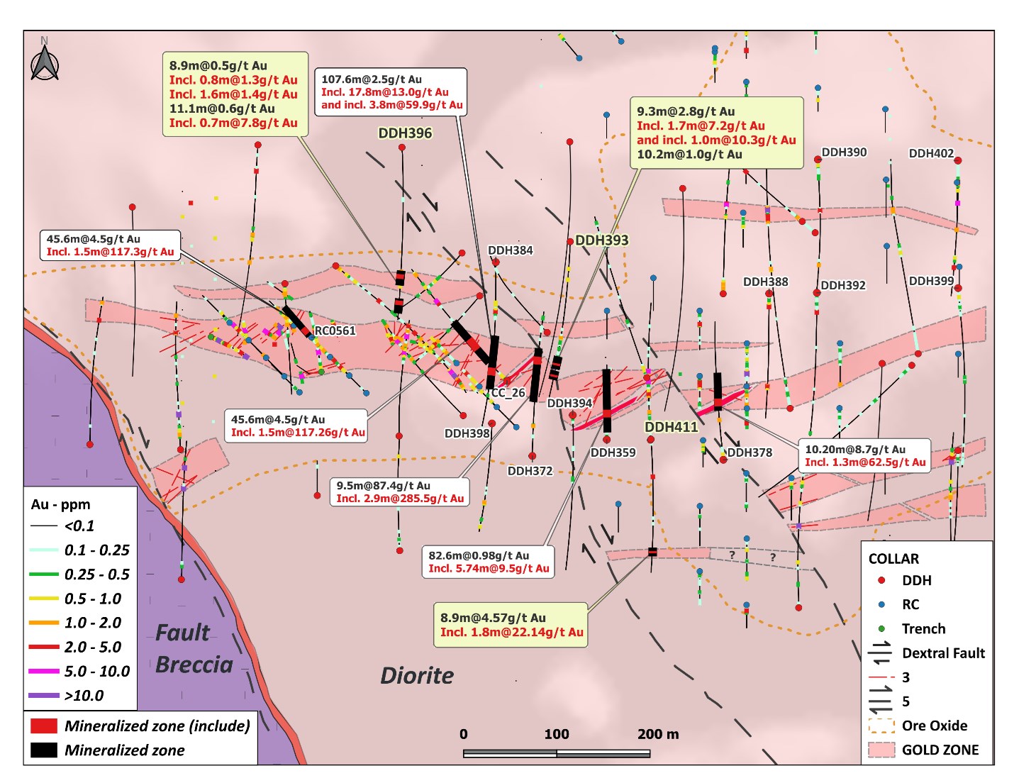
Figure 2: Map showing the location of recent drill holes at the Jerimum Cima target including DDH411 which returned 8.9m @ 5.8 g/t gold from 208.1m depth including 1.8m @ 28.4 g/t gold from 212.2m depth. Previous results from DDH372, DDH378, CC26, RC561, DDH359 and DDH384 are also shown on the map. Terms: g/t = grams / tonne, m = metres, Au = gold. True widths may be 50% of actual drill intercepts
To view an enhanced version of this graphic, please visit:
https://images.newsfilecorp.com/files/3900/311672_689530e6a4324b8f_003full.jpg
Notable results reported here include the results from DDH411 which was drilled on section 551187E and returned 8.9m @ 5.8 g/t gold from 208.1m depth including 1.8m @ 28.4 g/t gold from 212.2m depth (Figures 2 and 3, Table 1). The hole was drilled south of the main mineralized zone and away from the main zone to test for parallel mineralized features and it intersected a previously unrecognised zone with visible gold (Figure 4) which represents a new zone of gold mineralization located approximately 200m south of main mineralized zone at Jerimum Cima. This new zone is open to the east and west and at depth and requires follow up drilling.
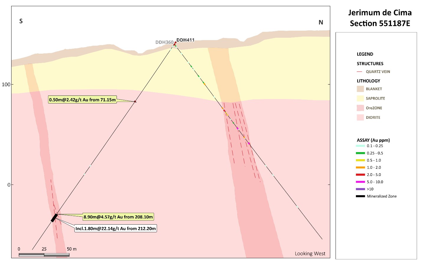
Figure 3: Cross section showing section 551187E at the Jerimum Cima discovery showing results from DDH411 which returned 8.9m @ 5.8 g/t gold from 208.1m depth including 1.8m @ 28.4 g/t gold from 212.2m depth. Note location of new mineralized zone approximately 200m south of Main mineralized zone at Jerimum Cima. DD411 was drilled at a dip of 50 degrees on a bearing of 180 degrees. True widths may be 50% of actual drill intercepts. Terms: g/t = grams / tonne, m = metres, Au = gold
To view an enhanced version of this graphic, please visit:
https://images.newsfilecorp.com/files/3900/311672_689530e6a4324b8f_004full.jpg
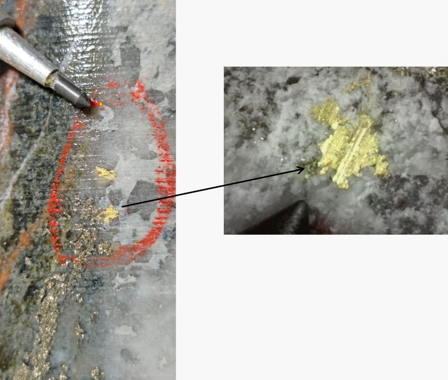
Figure 4: Visible gold in drill core from DDH411 at 212.2m depth. DDH411 returned 8.9m @ 5.8 g/t gold from 208.1m depth including 1.8m @ 28.4 g/t gold from 212.2m depth.
To view an enhanced version of this graphic, please visit:
https://images.newsfilecorp.com/files/3900/311672_689530e6a4324b8f_005full.jpg
DDH393 was drilled on section 551083E with an azimuth of 180 degrees and at an angle of 50 degrees and was designed to test the down dip extension of the northern mineralized zone which is parallel to the main E-W trending high grade zone at Jerimum Cima. The hole successfully intersected the mineralized zone and returned 9.3m @ 2.78 g/t gold from 207.1m depth including 1.7m @ 7.2 g/t gold from 207.1m depth and 10.2m @ 1.00 g/t gold from 225.0m depth (Figures 2 and 5, Table 1).
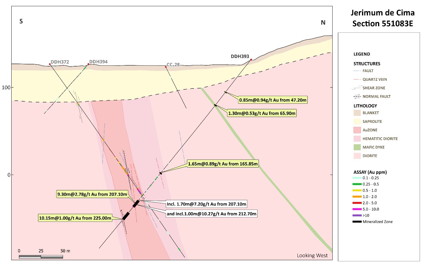
Figure 5: Cross section showing section 551083E at the Jerimum Cima discovery showing results from DDH393 which returned 9.3m @ 2.78 g/t gold from 207.1m depth including 1.7m @ 7.2 g/t gold, and 10.2m @ 1.00 g/t gold from 225.0m depth. DDH393 was drilled at a dip of 50 degrees on a bearing of 180 degrees. True widths may be 50% of actual drill intercepts. Terms: g/t = grams / tonne, m = metres, Au = gold
To view an enhanced version of this graphic, please visit:
https://images.newsfilecorp.com/files/3900/311672_689530e6a4324b8f_006full.jpg
DDH396 was drilled on section 550919E with an azimuth of 180 degrees and at an angle of 55 degrees. It similarly intersected the same northernmost mineralized zone as DDH393 and returned 8.9m @ 0.50 gold from 195.6m depth 11.1m @ 0.58 gold from 241.3m depth including 0.7m @ 7.82 g/t gold from 241.3m depth (Figure 2, Table 1).
The remaining holes were drilled outside the main mineralized zone and returned narrower mineralized intervals in the underlying hard rock material. Most of the diamond drill holes, however cut low grade gold values in the soil and blanket sediment suggesting the presence of a more extensive blanket than previously envisaged. Typical gold values from the blanket sediments returned in the holes reported herein include 26.0m @ 0.28 g/t gold from surface in DDH388, 34.9m @ 0.24 g/t gold from 1m depth in DDH392 and 36.7m @ 0.18 g/t gold from surface in DDH390 (Table 1).
| Drill Hole # | Weathering | From | To | Thickness | Grade | |
| (m) | (m) | (m) | g/t gold | |||
| DDH388 | Blanket | 0.0 | 26.0 | 26.0 | 0.28 | |
| Incl. | 25.0 | 26.0 | 1.0 | 3.01 | ||
| Intrusive rock | 183.5 | 185.0 | 1.5 | 1.76 | ||
| EOH 247.7 | ||||||
| DDH390 | Blanket | 0.0 | 36.7 | 36.7 | 0.18 | |
| Intrusive rock | 96.7 | 97.6 | 0.9 | 2.06 | ||
| 199.9 | 200.4 | 0.5 | 1.35 | |||
| EOH 273.2 | ||||||
| DDH392 | Blanket | 1.0 | 35.9 | 34.9 | 0.24 | |
| Intrusive rock | 252.0 | 253.2 | 1.2 | 0.35 | ||
| EOH 275.6 | ||||||
| DDH393 | Intrusive rock | 47.2 | 48.1 | 0.8 | 0.94 | |
| 65.9 | 67.2 | 1.3 | 0.53 | |||
| 165.9 | 167.5 | 1.7 | 0.89 | |||
| 207.1 | 216.4 | 9.3 | 2.78 | |||
| Incl. | 207.1 | 208.8 | 1.7 | 7.20 | ||
| and | 212.7 | 213.7 | 1.0 | 10.27 | ||
| 225.0 | 235.2 | 10.2 | 1.00 | |||
| EOH 278.5 | ||||||
| DDH394 | NSV | |||||
| EOH 247.0 | ||||||
| DDH396 | Intrusive rock | 195.6 | 204.5 | 8.9 | 0.50 | |
| Incl. | 198.3 | 199.0 | 0.8 | 1.34 | ||
| and | 202.9 | 204.5 | 1.5 | 1.41 | ||
| 241.3 | 252.4 | 11.1 | 0.58 | |||
| Incl. | 241.3 | 242.0 | 0.7 | 7.82 | ||
| EOH 270.2 | ||||||
| DDH398 | Intrusive rock | 146.3 | 150.7 | 4.4 | 0.69 | |
| Incl. | 147.3 | 148.0 | 0.8 | 1.65 | ||
| EOH 201.0 | ||||||
| DDH399 | Blanket | 0.0 | 20.0 | 20.0 | 0.20 | |
| Incl. | 13.9 | 15.8 | 2.0 | 0.80 | ||
| EOH 294.9 | ||||||
| DDH402 | Blanket | 0.0 | 27.0 | 27.0 | 0.14 | |
| Saprolite | 40.0 | 48.0 | 8.0 | 0.48 | ||
| Incl. | 40.0 | 40.6 | 0.6 | 4.03 | ||
| Intrusive rock | 79.5 | 80.3 | 0.8 | 7.19 | ||
| 129.5 | 130.6 | 1.1 | 1.30 | |||
| 183.2 | 184.2 | 1.0 | 0.85 | |||
| 201.7 | 202.2 | 0.5 | 2.96 | |||
| EOH 255.4 | ||||||
| DDH409 | Intrusive rock | 196.2 | 208.0 | 11.8 | 0.2 | |
| Incl. | 201.0 | 202.4 | 1.5 | 1.0 | ||
| EOH 250.9 | ||||||
| DDH411 | Intrusive rock | 71.2 | 71.7 | 0.5 | 2.4 | |
| Incl. | 208.1 | 217.0 | 8.9 | 5.8 | ||
| EOH 251.1 | 212.2 | 214.0 | 1.8 | 28.4 | ||
Table 1: Significant drill results from diamond drill holes DDH388, DDH390, DDH392, DDH393, DDH394, DDH396 DDh398, DDH402, DDH409 and DDH411 at the Jerimum Cima discovery. All holes were drilled at a dip of 55 degrees except for DDH393 and DDH394 which were drilled at a 50 degree dip. All holes were drilled on a bearing of 180 degrees. Terms: g/t = grams / tonne, m = metres, Au = gold, EOH = end of hole. NSV = no significant values True widths may be 50% of actual drill intercepts
The primary objective of the current drilling program at Jerimum Cima is generating maiden resources for the gold-in-oxide blanket and the underlying primary mineralized zones at the. Diamond drilling at Jerimum Cima is ongoing and currently investigating the eastern extension of Jerimum Cima mineralization. Diamond and RC drilling is also ongoing at the Machichie Main deposit and the Machichie West target with the objective of updating the global resource base later this year.
Granting of Options
Cabral's Board of Directors has also approved the granting of stock options pursuant to the Omnibus Equity Incentive Plan to 34 employees and one officer that have joined the Company in recent months. The stock options entitle the holders to purchase a total of 3,078,000 common shares in the capital stock of the Company at a price of $1.35 per common share, are exercisable for five years and subject to vesting over 24 months.
About Cabral Gold Inc.
The Company is a junior resource Company engaged in the exploration, development and near-term production from gold properties located in Brazil. The Company has a 100% interest in the Cuiú Cuiú gold district located in the Tapajós Region, within the state of Pará in northern Brazil. Three main gold deposits have so far been defined at the Cuiú Cuiú project which contain National Instrument ("NI") 43-101 compliant Indicated resources of 12.29Mt @ 1.14 g/t gold (450,200oz) in fresh basement material and 13.56Mt @ 0.50 g/t gold (216,182oz) in oxide material. The project also contains Inferred resources of 13.63Mt @ 1.04 g/t gold (455,100oz) in fresh basement material and 6.4Mt @ 0.34 g/t gold (70,569oz) in oxide material. The resource estimate for the primary material is based on the NI 43-101 technical report dated October 12, 2022. The resource estimate for the oxide material at PDM and MG is based on a NI 43-101 technical report dated October 21, 2024. The resource estimate for the oxide material at Central and Machichie is based on a NI43-101 technical report ("Updated PFS") dated July 29, 2025. The Company is currently engaged in the construction of a Phase 1 gold-in-oxide heap leach operation based on the NI43-101 technical report PFS and expects to enter commercial gold production in Q4 2026.
The Tapajós Gold Province is the site of the largest gold rush in Brazil's history which according to the ANM (Agência Nacional de Mineração or National Mining Agency of Brazil) produced an estimated 30 to 50 million ounces of placer gold between 1978 and 1995. Cuiú Cuiú was the largest area of placer workings in the Tapajós and produced an estimated 2Moz of placer gold historically.
FOR FURTHER INFORMATION PLEASE CONTACT:
"Alan Carter"
President and Chief Executive Officer
Cabral Gold Inc.
Tel: 604.676.5660
Quality Assurance / Quality Control
Cabral maintains a Quality Assurance / Quality Control ("QAQC") program for all its exploration projects using industry best practices. Key elements of the QAQC program include verifiable chain of custody for samples, regular insertion of certified reference materials, blanks, and duplicates, as well as check assays on results. RC samples are split, collected in plastic sample bags, and sealed on drill hole location. Drill core is halved by saw cut or slicer (in soft saprolite). RC and core samples are shipped in sealed bags by independent contractor to SGS GEOSOL Laboratorios in Vespasiano, Brazil, an independent analytical services provider with global certifications for Quality Management Systems (ISO 9001:2015 and ISO 14001:2015 (ABS Certificates 32982 and 39911) and ISO/IEC 17025:2017 accreditation (CRL-0386)). Gold analyses are routinely performed via 50g fire assay with secondary assay techniques applied on higher grade samples. Final assay results are validated by Cabral Geological Staff prior to insertion into the database. Additional information regarding the Company's data verification processes is set out in the CBR, 43-101, PFS Technical Report, July 2025, which can be found on the Company's website.
Qualified Person and Technical Information
Technical information included in this release was supervised and approved by Brian Arkell, B.S. Geology and M.S. Economic Geology, SME (Registered Member), AusIMM (Fellow) and SEG (Fellow), Cabral Gold's Vice President, Exploration and Technical Services, and a Qualified Person under NI 43-101.
Neither the TSX Venture Exchange nor its Regulation Services Provider (as such term is defined in the policies of the TSX Venture Exchange) accepts responsibility for the adequacy or accuracy of this release.
Forward-looking Statements
This news release contains certain forward-looking information and forward-looking statements within the meaning of applicable securities legislation (collectively "forward-looking statements"). The use of the words "will", "expected" and similar expressions are intended to identify forward-looking statements. These statements involve known and unknown risks, uncertainties and other factors that may cause actual results or events to differ materially from those anticipated in such forward-looking statements. Such forward-looking statements should not be unduly relied upon. The Company believes the expectations reflected in those forward-looking statements are reasonable, but no assurance can be given that these expectations will prove to be correct.

To view the source version of this press release, please visit https://www.newsfilecorp.com/release/311672
Source: Cabral Gold Inc.