
Vancouver, British Columbia--(Newsfile Corp. - October 23, 2026) - Spark Energy Minerals Inc. (CSE: SPRK) (OTC Pink: SPARF) (FSE: 8PC) ("Spark" or the "Company") reports surface sampling results that guide the next exploration steps at Boa Vista and Encachoeirado, within its Arapaima Project in Minas Gerais, Brazil. The results bring Boa Vista's rare earth zone into focus at surface and identify rare earth and gallium anomalies at the undrilled Encachoeirado target.
Surface Results Point to the Next Exploration Opportunities
1.54% TREO in soil. ARA-SL-219, collected on strongly kaolinized Caladão Granite saprolite at Boa Vista, returned 15,434 ppm (1.54%) TREO with 35.3% MREO/TREO and 5,171 ppm NdPr. ARA-SL-080, a pink clayey soil, returned 3,047 ppm TREO with 29.3% MREO/TREO.
About half of the soils above 500 ppm TREO. Forty of the 81 Boa Vista soil samples exceeded 500 ppm TREO. The gallium results for these samples (59 above 50 g/t Ga₂O₃, up to 134.4 g/t) were reported on September 24, 2026.
Rare earths at surface. The five maiden holes at Boa Vista intersected the rare earth zone from 20 to 32 m below surface, beneath the gallium-rich horizon. The soils show the same zone at surface on the slopes, where the upper horizon has been stripped, as at the Cruzeta road cut (at least 2.00% TREO in a grab sample; 22 m averaging 2,392 ppm TREO in channel; October 8, 2026).
Encachoeirado, a third target. Six of 65 stream-sediment samples exceeded 500 ppm TREO, with a maximum of 1,621 ppm (ARA-SS-292a); a pegmatite-biotitite rock chip (ARA-CR-184) returned 2,428 ppm TREO with 637 ppm Li₂O and 137.1 g/t Ga₂O₃; and five of 13 soils exceeded 50 g/t Ga₂O₃. Not yet drilled.
Next steps. Close-spaced soil sampling and RC holes sited where the rare earth zone is exposed at Boa Vista; trenching and channel sampling at Encachoeirado. Subject to financing.
Comment from the CEO
"At Cruzeta, the road cut showed us the rare earth zone at surface. At Boa Vista, the soils are telling us the same thing. Where the gallium-rich upper horizon has been stripped by erosion or by a road cut, the rare earth zone is at surface, and the best of those soils, at 1.54% TREO, is of the same order as the grab sample we reported at Cruzeta. The model that led us to Boa Vista now explains what we see at surface at both drilled targets. Our next holes at Boa Vista will be sited where the zone is exposed, so that they test it from the first meter. A single sample does not make a deposit, but a soil dataset that behaves the way the model predicts is a good reason to drill," said Dr. Fernando Tallarico, P.Geo., FSEG, Chief Executive Officer and Chairman.
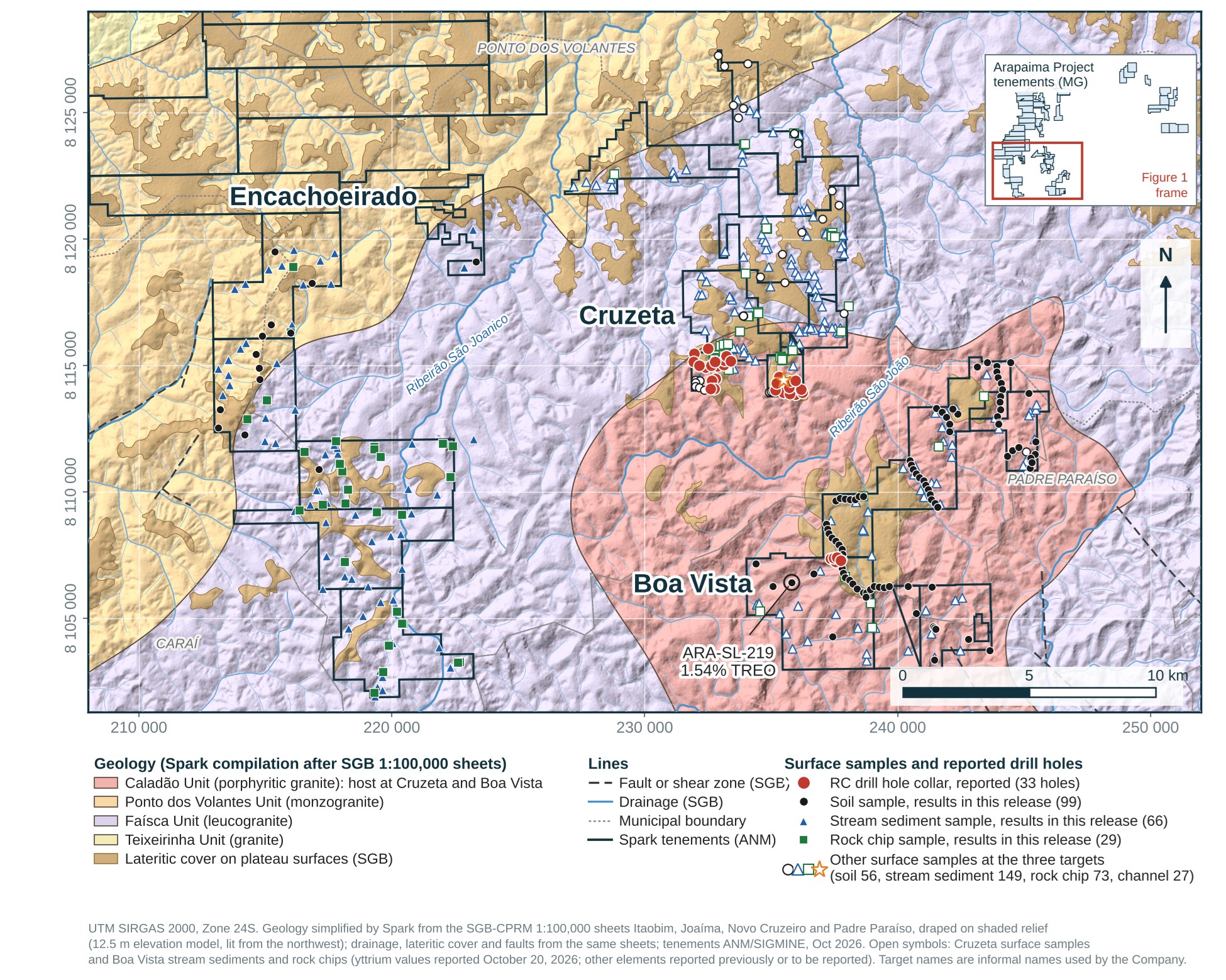
Figure 1. The Cruzeta, Boa Vista and Encachoeirado targets, Arapaima Project: geology (Company compilation after the SGB-CPRM 1:100,000 sheets) draped on shaded relief, with the lateritic cover of the plateau surfaces, drainage, faults and the Spark tenements; the surface samples at the three targets by sample medium; and the 33 publicly reported RC drill holes. Filled symbols are the samples reported in this news release (the Boa Vista soils and the Encachoeirado samples); open symbols are the Cruzeta surface samples and the Boa Vista stream-sediment and rock-chip samples, whose yttrium values were reported on October 20, 2026. Inset: position of the map within the Arapaima tenements.
To view an enhanced version of this graphic, please visit:
https://images.newsfilecorp.com/files/10093/320519_caaa839b84664bd5_002full.jpg
Boa Vista: Magnet Rare Earth Oxides Account for 35.3% of the Peak Soil TREO Result
Boa Vista lies 7 to 8 km south of Cruzeta (Figure 1). Five maiden reverse circulation (RC) holes, reported on August 27, 2026, returned gallium from surface in every hole and a rare earth zone starting 20 to 32 m below surface, with composites of 1,188 to 1,565 ppm TREO and 17.3% to 23.4% MREO/TREO.
The surface results reported on September 24, 2026 covered the gallium signature of the soils, with 63 of the 86 soils then reported above 50 g/t Ga₂O₃ and a maximum of 134.4 g/t (ARA-SL-062). Five of those soils (ARA-SL-075 to -078 and ARA-SL-144) plot outside the Company's tenements and are not included in this news release.
The rare earth results for the other 81 soils are reported here. ARA-SL-219, collected on strongly kaolinized Caladão Granite saprolite, or weathered rock, about 2 km west-southwest of the maiden holes, returned 15,434 ppm (1.54%) TREO with 35.3% MREO/TREO and 5,171 ppm NdPr, and ARA-SL-080, a pink clayey soil, returned 3,047 ppm TREO with 29.3% MREO/TREO (Table 1; Figure 2).
Gallium in ARA-SL-219 was below the detection limit, as it was in the Cruzeta grab sample, a pattern consistent with both samples coming from below the gallium-rich horizon.
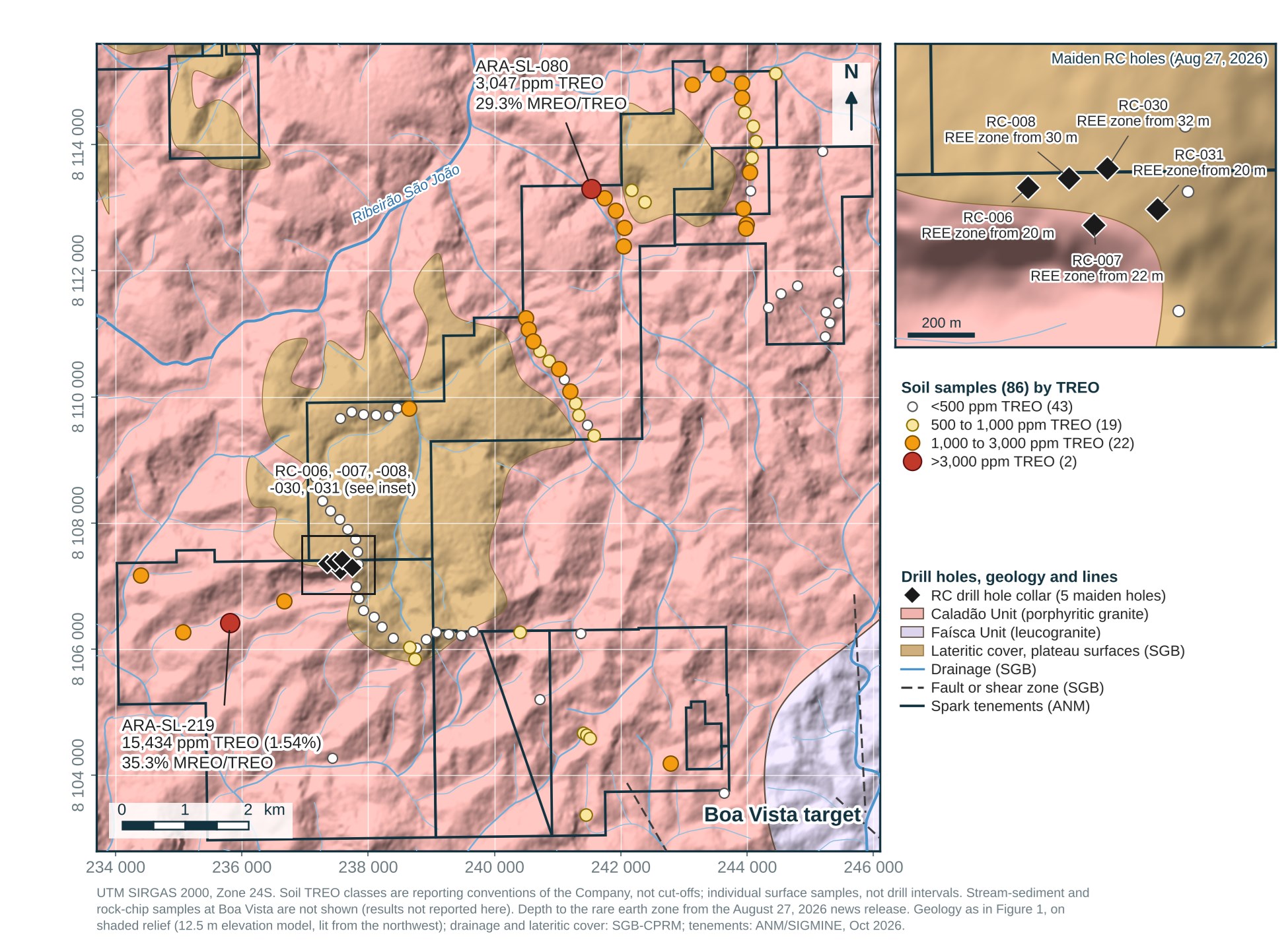
Figure 2. Boa Vista target: the 81 soil samples classed by TREO, with the five maiden RC holes, on the geology and shaded relief of Figure 1. Inset: the holes and the depth at which each intersected the rare earth zone (August 27, 2026). The holes were collared on the lateritic cover of a plateau surface; ARA-SL-219 lies about 2 km to the west-southwest, on saprolite outside the mapped lateritic cover. Stream-sediment and rock-chip samples at Boa Vista are not shown; their results are not reported here.
To view an enhanced version of this graphic, please visit:
https://images.newsfilecorp.com/files/10093/320519_caaa839b84664bd5_003full.jpg
The soils were collected along access routes, where road cuts and slopes expose the weathering profile beneath the gallium-rich upper horizon. The Company interprets the rare earth-rich soils as samples of the rare earth zone where it reaches surface (Figure 3). In the five maiden holes the zone lies 20 to 32 m below surface and follows the topography; on the slopes and in road cuts, where the upper horizon has been removed, it is at surface.
The same relationship was reported at the Cruzeta road cut on October 8, 2026, where channel sampling of exposed saprolite averaged 2,392 ppm TREO over 22 m and a grab sample of lightly weathered granite returned at least 2.00% TREO (praseodymium exceeded the laboratory's upper limit; the over-limit analysis is pending).
ARA-SL-219 is a single sample. Its grade is of the same order as that grab sample and about ten times the drill composites, and the planned work will test whether it reflects local primary rare earth enrichment in the granite, as proposed at Cruzeta, or secondary enrichment in the saprolite.
Table 1. Boa Vista: the two highest soil TREO results. All 81 soil results are in Appendix Table A1.
| Sample | Material | TREO (ppm) | MREO/TREO (%) | NdPr (ppm) | Ga₂O₃ (g/t) |
| ARA-SL-219 | kaolinized saprolite, Caladão Granite | 15,434 | 35.3 | 5,171 | <1.3 |
| ARA-SL-080 | pink clayey soil | 3,047 | 29.3 | 866 | 48.4 |
MREO/TREO is the magnet rare earth share of TREO; NdPr is Nd₂O₃ + Pr₆O₁₁; "<" indicates a result below the detection limit (shown as oxide). Individual surface samples; not drill intervals.
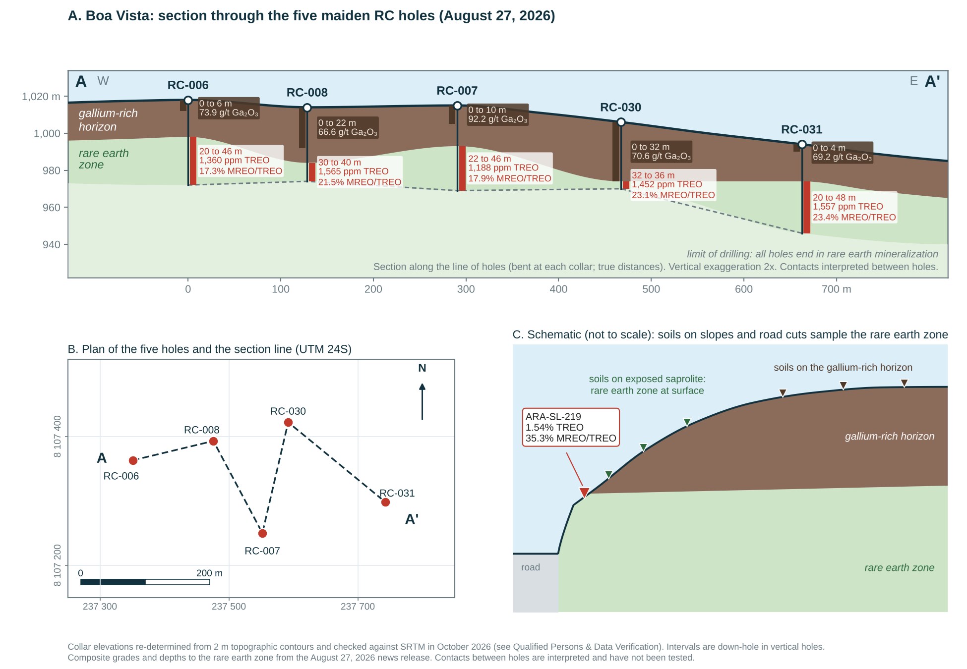
Figure 3. Boa Vista. A: section along the line of the five maiden RC holes (true distances between collars; vertical exaggeration 2x): gallium from surface in every hole and the rare earth zone 20 to 32 m below surface, sub-parallel to the topography; contacts interpreted between holes; collar elevations as corrected in October 2026 (see Qualified Persons & Data Verification). B: plan of the holes and the section line. C: schematic relationship of the soil samples to the weathering profile (not to scale).
To view an enhanced version of this graphic, please visit:
https://images.newsfilecorp.com/files/10093/320519_caaa839b84664bd5_004full.jpg
Encachoeirado Adds an Undrilled Gallium and Rare Earth Target
Encachoeirado is a new target in the south-west of the project area, approximately 16 km west-southwest of the Cruzeta drilling (Figure 1). It has not been drilled. Reconnaissance sampling comprised 65 stream-sediment, 29 rock-chip and 13 soil samples within the Company's tenements; all results are listed in Appendix Tables A2 to A4 (selected results in Table 2).
Six of the 65 stream-sediment samples exceeded 500 ppm TREO, with a maximum of 1,621 ppm TREO and 19.7% MREO/TREO in ARA-SS-292a, and three exceeded 50 g/t Ga₂O₃, with a maximum of 64.5 g/t (ARA-SS-313).
Four of the 29 samples of the rock-chip series exceeded 500 ppm TREO, led by a pegmatite-biotitite sample, ARA-CR-184, with 2,428 ppm TREO, 20.3% MREO/TREO, 637 ppm Li₂O, 239 ppm Nb₂O₅ and 137.1 g/t Ga₂O₃. The other three, ARA-CR-168 (1,212 ppm), ARA-CR-165 (657 ppm) and ARA-CR-186 (520 ppm), are soil and saprolite material collected within the same series; 17 of the 29 samples in the series are soils and are identified as such in Appendix Table A2.
None of the 13 soil samples exceeded 500 ppm TREO (maximum 481 ppm, ARA-SL-130), and five returned more than 50 g/t Ga₂O₃, with a maximum of 65.9 g/t (ARA-SL-121).
The gallium in ARA-CR-184 occurs in a biotite-rich rock and is interpreted as a lithological signature of the mica, not as the adsorbed gallium of the weathering profile at Cruzeta and Boa Vista; its lithium and niobium values are pathfinder-level anomalies for pegmatite.
Stream-sediment anomalies locate catchments, not sources. ARA-SS-292a, the highest stream-sediment result, is isolated: the samples upstream (ARA-SS-295a, 370 ppm) and downstream (ARA-SS-288a, 136 ppm) on the same drainage, and on the adjoining tributary (ARA-SS-291a, 229 ppm), are below 500 ppm TREO.
Follow-up will trace the anomalous drainages upstream (ARA-SS-289a, -292a, -316, -317, -347 and -350), map and sample the pegmatite-biotitite body around ARA-CR-184, and test the soils at closer spacing.
Table 2. Encachoeirado: selected results by sample medium. All results are in Appendix Tables A2 to A4.
| Sample | Medium | TREO (ppm) | MREO/TREO (%) | NdPr (ppm) | Ga₂O₃ (g/t) | Li₂O (ppm) |
| ARA-CR-184 | rock chip, pegmatite-biotitite | 2,428 | 20.3 | 451 | 137.1 | 637 |
| ARA-CR-168 | soil (rock-chip series) | 1,212 | 19.7 | 221 | 41.7 | 32 |
| ARA-SS-292a | stream sediment | 1,621 | 19.7 | 293 | 14.8 | 30 |
| ARA-SL-121 | soil | 126 | 16.8 | 17 | 65.9 | 26 |
Rock chips are selective samples and may not be representative. Stream sediments reflect transported material from the upstream catchment. Individual surface samples; not drill intervals.
Surface Sampling Guides the Next Tests at Boa Vista and Encachoeirado
The following work is planned, subject to field conditions, financing and required permits and access permissions (see Cautionary Statements on Exploration Results and the Cautionary Statement Regarding Forward-Looking Information below):
Close-spaced soil sampling at Boa Vista around ARA-SL-219 and ARA-SL-080 and along the slopes and road cuts where saprolite is exposed, to map the rare earth zone at surface.
RC holes at Boa Vista sited where the rare earth zone is exposed, to test it from surface, together with the step-out and infill holes around the five maiden holes announced on August 27, 2026.
At Encachoeirado, repeat and upstream stream-sediment and soil sampling in the catchments of ARA-SS-289a, -292a, -316, -317, -347 and -350, mapping, trenching and channel sampling of the pegmatite-biotitite body around ARA-CR-184, and mineralogical characterization of the host minerals.
Reporting of surface results from the remaining Arapaima targets as the database review is completed.
Technical Notes & Reporting Basis
TREO is the sum of La₂O₃, CeO₂, Pr₆O₁₁, Nd₂O₃, Sm₂O₃, Eu₂O₃, Gd₂O₃, Tb₄O₇, Dy₂O₃, Ho₂O₃, Er₂O₃, Tm₂O₃, Yb₂O₃, Lu₂O₃ and Y₂O₃. MREO (magnet rare earth oxides) is Nd₂O₃ + Pr₆O₁₁ + Dy₂O₃ + Tb₄O₇; NdPr is Nd₂O₃ + Pr₆O₁₁. MREO and NdPr are included within TREO and must not be added to it; MREO/TREO is calculated for each sample from the oxide sums. Ga₂O₃ = Ga × 1.3442; Li₂O = Li × 2.1525; Nb₂O₅ = Nb × 1.4305; Sc₂O₃ = Sc × 1.5338. One g/t equals one ppm. Oxide values are calculated analytical equivalents of the elemental assays, not recoverable products, and gallium oxide values are not elemental gallium grades.
Results below the detection limit are reported as "<" followed by the detection limit converted to oxide and are not substituted; where a component of a sum is below the detection limit, the sum is calculated with that component at the detection limit and reported with "<".
"Mineralization" and "anomalous" in this news release mean values above 500 ppm TREO, 50 g/t Ga₂O₃ or 100 ppm Li₂O in an individual sample; these thresholds are reporting conventions of the Company, not economic cut-offs.
The Appendix lists every sample collected within the Company's tenements in the programs reported here, including samples below the reporting thresholds: all 81 soil samples at Boa Vista and all 29 rock-chip, 13 soil and 65 stream-sediment samples at Encachoeirado, with coordinates, sample type and the field description of the sampled material, so that the results can be assessed as a whole. Six further samples, ARA-SL-075 to -078 and ARA-SL-144 at Boa Vista and ARA-SS-361 at Encachoeirado, plot outside the Company's tenements in the ANM SIGMINE layer (October 2026), 37 to 772 m from the nearest boundary, and are not reported. In the ANM registry, the Boa Vista soils lie on exploration permits and on exploration applications: 46 of the 81, including ARA-SL-080, lie on applications 830.189/2023 and 831.922/2024, for which exploration permits have not yet been granted.
Sampling, Analysis & Quality Control
Soil samples were collected by Company geologists along access routes at approximately 200 m spacing, with additional samples where the sampled material changed. Each soil sample of approximately 5 kg was taken at a depth of 50 cm or more, below the stone line where one was present, preferably from the B or C soil horizon. The field description records the color and texture of the material and, where observed, the parent material (for example saprolite). Rock-chip samples were collected from exposed fresh or weathered rock and are selective by nature; at Encachoeirado, 17 of the 29 samples of the rock-chip series are soils, and three are saprolite or regolith (Appendix Table A2). Stream-sediment samples were collected from active drainage channels, classified in the field as primary (36 samples), secondary (26) and tertiary (3) drainages, and were sieved in the field at 60 mesh (250 µm) or finer. At the laboratory every sample was prepared as received, without further size fractionation (see below). Sample locations were recorded with handheld GPS units in SIRGAS 2000 UTM Zone 24S; the horizontal accuracy of individual readings was not recorded and is typically within 3 to 10 m for such units.
Samples were prepared and analyzed by SGS Geosol Laboratórios S.A. (SGS Geosol Laboratórios Ltda. for the 2025 batches) in Vespasiano, Minas Gerais, Brazil, a commercial laboratory that is independent of the Company and is ISO 9001:2015 and ISO 14001:2015 certified. Preparation (PRP70J_A2) comprised drying at 105 °C, crushing to 75% passing 3 mm, Jones riffle splitting and pulverizing of a 250 g split to 95% passing 150 mesh (106 µm). Analysis was by sodium peroxide fusion with ICP-OES and ICP-MS finish (ICM90A) for 56 elements. Laboratory quality control in the 10 batches that contain the samples reported here comprised 16 preparation blanks, 15 preparation duplicates, 15 pulp replicates and 24 analyses of the certified reference materials OREAS 460, OREAS 461, OREAS 753, AMIS0683 and AMIS0684. The preparation blanks returned at most 4.8 ppm TREO and gallium below the detection limit; the duplicate and replicate pairs agreed within 9.4% for TREO (median 3.0%); and OREAS 460, the reference material inserted in 9 of the 10 batches, returned TREO with a coefficient of variation of about 3.5% between batches. Compared with their certified values, the reference-material results for the rare earth elements were within three standard deviations, except samarium in three batches (about 9% low) and erbium in one (11% high); on average the rare earth results were 2 to 6% below the certified values, and OREAS 460 returned 95% of its certified TREO, so the reported rare earth values are, if anything, slightly understated. Gallium and lithium in AMIS0683, AMIS0684 and OREAS 753 were within three standard deviations, except gallium in OREAS 753 in one 2025 batch, which was 22% low. None of the reference materials used carries a certified fusion value for scandium. No Company-inserted blanks, duplicates or reference materials were included in these surface batches; the Company's controls (ITAK QG-01 blank; ITAK-713, ITAK-715, GRE-07 and GRE-13 reference materials) were used in the RC drilling program.
Qualified Persons & Data Verification
Jonathan Victor Hill, BSc (Hons), FAusIMM, VP Exploration, Country Manager and Director, and Dr. Fernando Tallarico, P.Geo., FSEG, Chief Executive Officer and Chairman, are Qualified Persons as defined in National Instrument 43-101, Standards of Disclosure for Mineral Projects. They have prepared or supervised the preparation of the scientific and technical information in this news release, including the interpretations, and have reviewed and approved it. Neither is independent of the Company.
The Qualified Persons have verified the data disclosed, including the sampling, analytical and test data underlying the information and opinions in this news release, by comparing every value in the text, tables and Appendix against the SGS Geosol certificates of analysis (188 samples in 10 certificates; all element values and derived oxide totals match); reviewing the laboratory quality-control results for the batches reported; checking the sample identifiers, coordinates and field descriptions against the field records; and reviewing the chain of custody from the field to the laboratory. As part of this review, the collar elevations (RL) of the RC holes were re-determined by interpolation of 2 m topographic contours and checked against the SRTM-based digital elevation model (SRTM 30 m and its 12.5 m ALOS PALSAR resampling). The corrected elevations agree with the model within 15 m for 32 of the 33 holes reported to date (median difference 6 m; maximum 19 m, ARA-RC-025). The previously published elevations were handheld GPS readings; they differed from the model by more than 15 m for 24 of the 33 holes, by up to 142 m (ARA-RC-033). At Boa Vista the corrected RLs are 1,018 m (ARA-RC-006, previously 1,015 m), 1,015 m (ARA-RC-007, previously 1,018 m), 1,014 m (ARA-RC-008, unchanged), 1,006 m (ARA-RC-030, previously 903 m) and 994 m (ARA-RC-031, previously 980 m); at Cruzeta, for example, 944 m for ARA-RC-033 (previously 796 m) and 915 m for ARA-RC-034 (previously 826 m). All holes are vertical and the intervals are measured down-hole, so the reported intervals and grades are unaffected. The corrected elevations of the 28 Cruzeta holes are included in the updated public assay spreadsheet for Cruzeta; those of the Boa Vista holes are stated above. The verification is subject to the following limitations: the samples were collected by Company personnel; no independent sampling, resampling or check analysis at a second laboratory has been undertaken; sample coordinates are handheld GPS readings; collar elevations have not been surveyed by differential GPS; and the Qualified Persons have not independently audited the laboratory's internal procedures beyond its certification and quality-control record.
Cautionary Statements on Exploration Results
Early-stage results. The results in this news release come from reconnaissance surface sampling: 81 soil samples at Boa Vista and 29 rock-chip, 13 soil and 65 stream-sediment samples at Encachoeirado. They are individual samples, not drill intersections, channel averages or composite grades. They are preliminary, and they are not conclusive evidence of the presence or absence of an economic deposit.
Limitations of surface samples. Soils were collected along access routes rather than on a regular grid, so their distribution is biased toward roads and tracks, and each result represents the material at one point and depth only. Rock chips are selective and may not represent the average grade of the outcrop or rock unit sampled. Stream sediments integrate material transported from the upstream catchment and do not locate or grade a source. No sample in this news release establishes the continuity, thickness, extent or grade of mineralization at depth or between sample points, and continuity between the surface samples and the drill holes at Boa Vista has not been demonstrated.
Interpretations. The statements that the rare earth zone intersected in the Boa Vista drill holes reaches surface, that the soils sample that zone, and that the exploration model developed at Cruzeta applies at Boa Vista and Encachoeirado, are interpretations of the Qualified Persons based on the field descriptions, the assay results, the drill results and the topography. They have not been tested by drilling or trenching at the sample sites and may change as work proceeds. The comparison of ARA-SL-219 with the grab sample at the Cruzeta road cut is a comparison of two individual samples 7 to 8 km apart; it does not imply that the targets are connected, that either is mineralized throughout, or that either value is representative. A single sample does not establish a grade.
Terminology. "Discovery", "target", "zone", "horizon", "model" and "mineralization" are used in their exploration sense and do not mean that a mineral resource or mineral reserve has been identified. No mineral resource or mineral reserve has been estimated for any part of the Arapaima Project. The Company is not disclosing an exploration target within the meaning of NI 43-101, and no potential quantity or grade should be inferred from the sample counts, thresholds or maps in this news release. No preliminary economic assessment or other economic analysis has been completed. There is no certainty that further work will define a mineral resource or that any mineral resource, if defined, can be extracted economically.
Mineralogy and recovery. The rare earth mineralization at Arapaima is interpreted as ionic adsorption clay (IAC) style, but this has not been confirmed. The analytical method is a total digestion and does not measure the proportion of the rare earths, or of the gallium, that is ionically adsorbed or otherwise recoverable. No metallurgical test result has been reported for any element from Arapaima and no recovery has been demonstrated. The gallium value in the pegmatite-biotitite sample at Encachoeirado is interpreted as a mineralogical signature of the mica, not as evidence of adsorbed gallium.
Previously disclosed information. The surface results in this news release have not been disclosed before, except the gallium results of the Boa Vista soils (September 24, 2026), the yttrium oxide values of the surface samples, which are included in the TREO values reported here (October 20, 2026), and the drill and road-cut results referred to for context (August 27 and October 8, 2026). Previously reported assay results are unchanged. The collar elevations published in the Company's earlier drilling news releases and in its public assay spreadsheet have been corrected as described under Qualified Persons & Data Verification; the reported intervals and grades are unchanged.
Cautionary Note to United States Investors
This news release uses terms defined in NI 43-101 and the CIM Definition Standards for Mineral Resources and Mineral Reserves. The Company's securities are quoted on the OTC Pink market in the United States. United States investors are cautioned that these terms, and the disclosure requirements of NI 43-101, differ from those of the United States Securities and Exchange Commission under subpart 1300 of Regulation S-K, and that the information in this news release has not been prepared in accordance with United States standards. No mineral resource or mineral reserve has been estimated under either standard.
About Spark Energy Minerals Inc.
Spark Energy Minerals Inc. is a Canadian critical minerals exploration company whose principal asset, the Arapaima Project, comprises approximately 91,900 hectares across several municipalities in the Lithium Valley region of Minas Gerais, Brazil. The Company has made gallium and rare earth element discoveries at Cruzeta and Boa Vista, where mineralization is hosted in ionic adsorption clays developed over the Caladão Granite. Lithium-bearing pegmatites are a secondary target on the property. The Company also holds the Seridó Project, comprising twelve exploration permits totaling 21,492.74 hectares in the Seridó tungsten district of Rio Grande do Norte, where tungsten-focused reconnaissance exploration is underway.
For further information
Spark Energy Minerals Inc. | Dr. Fernando Tallarico, P.Geo., FSEG, Chief Executive Officer and Chairman
Email: connect@sparkminerals.co | Tel: +1-877-272-9226 | www.sparkminerals.co
On behalf of the Board of Directors of Spark Energy Minerals Inc.
Neither the Canadian Securities Exchange nor its Regulation Services Provider accepts responsibility for the adequacy or accuracy of this release.
Cautionary Statement Regarding Forward-Looking Information
This news release contains forward-looking information within the meaning of applicable Canadian securities legislation, including National Instrument 51-102. Forward-looking information in this news release includes, without limitation: the interpretation that the rare earth zone intersected in the Boa Vista drill holes reaches surface on the slopes and in road cuts and that the soil sampling maps that zone; the interpretation that the exploration model developed at Cruzeta applies at Boa Vista and Encachoeirado; the characterization of Encachoeirado as a target and of the gallium in sample ARA-CR-184 as a mineralogical signature; the planned close-spaced soil sampling, trenching, channel sampling, mineralogical characterization and drilling, including the intention to site drill holes where the rare earth zone is interpreted to be exposed; the planned reporting of results from other targets; and any statement about what further work may show, find or confirm. Words such as "interpreted", "planned", "will", "intends", "expects", "potential" and "may" identify forward-looking information.
Forward-looking information is based on the following material factors and assumptions: that the samples, field descriptions and SGS Geosol analyses are accurate and representative of the material sampled; that the geological interpretations of the Qualified Persons, including the vertical zonation of gallium above rare earths and its relationship to topography, are correct; that the Company will obtain the financing required for the planned work on acceptable terms and in time for the planned schedule; that the Company's exploration permits remain in good standing and that its pending exploration applications are granted and that landowner, environmental and other access permissions will be obtained in the ordinary course; that drilling and laboratory contractors will be available; and that weather and field conditions will allow the work to proceed.
Actual results may differ materially from those expressed or implied by the forward-looking information because of risks that include: the inherent uncertainty of mineral exploration, including the risk that additional sampling, trenching or drilling does not confirm the interpretations, the continuity or the values reported here; the risk that individual sample results, including the highest values, are not reproduced by closer-spaced work; the risk that the rare earth and gallium mineralization is not of ionic adsorption clay style, is not continuous, or is not amenable to economic recovery; the risk that no mineral resource is ever defined; metallurgical risk; the availability and cost of financing and the dilution that equity financing causes; commodity-price risk for rare earths and gallium, including the concentration of supply in a small number of countries and the effect of export controls on those markets; errors in the Company's exploration database, including the collar elevations referred to under Qualified Persons & Data Verification; title, permitting, environmental, community, regulatory and political risks in Brazil; and the other risks described in the Company's filings on SEDAR+ at www.sedarplus.ca. Forward-looking information is provided as of the date of this news release for the purpose of describing the Company's current expectations and plans, and readers are cautioned not to place undue reliance on it. The Company does not undertake to update forward-looking information except as required by law.
Appendix: Complete Surface Sample Results
All samples collected in the programs reported here, including those below the reporting thresholds. Coordinates in SIRGAS 2000 UTM Zone 24S (handheld GPS). Material is the field description recorded at collection. Values below the detection limit are shown as "<" followed by the detection limit converted to oxide. Scandium is reported as Sc₂O₃ = Sc × 1.5338.
Table A1. Boa Vista target: all 81 soil samples, sorted by TREO (highest first).
| Sample | Easting | Northing | Material (field description) | TREO (ppm) | MREO/TREO (%) | NdPr (ppm) | Ga₂O₃ (g/t) | Sc₂O₃ (g/t) | Nb₂O₅ (ppm) |
| ARA-SL-219 | 235811 | 8106422 | White to pink, extremely kaolinized saprolitized Caladão granite | 15,434 | 35.3 | 5,171 | <1.3 | 13.8 | 80 |
| ARA-SL-080 | 241533 | 8113302 | Pink, Clayey | 3,047 | 29.3 | 866 | 48.4 | 7.7 | 60 |
| ARA-SL-109 | 240490 | 8111254 | Pink, 0.48 µSv/h, pinkish soil immediately above saprolite of porphyritic granitic rock, angular granules of quartz are abundant | 2,466 | 0.9 | 19 | 48.4 | 13.8 | 129 |
| ARA-SL-083 | 242052 | 8112680 | Brown, Clayey | 2,387 | 31.9 | 743 | 44.4 | <7.7 | 49 |
| ARA-SL-084 | 242043 | 8112390 | Brown, Clayey | 2,127 | 28.9 | 593 | 41.7 | <7.7 | 56 |
| ARA-SL-079 | 243990 | 8112739 | Orange, Sandy-Clayey | 1,971 | 19.4 | 365 | 63.2 | 18.4 | 93 |
| ARA-SL-220 | 236669 | 8106763 | Orange to pink soil near the charnockite | 1,870 | 1.5 | 23 | 53.8 | 19.9 | 196 |
| ARA-SL-157 | 243978 | 8112674 | Intense orange clayey soil | 1,853 | 11.5 | 203 | 80.7 | 23.0 | 109 |
| ARA-SL-218 | 235071 | 8106275 | Caladão saprolite | 1,613 | 29.5 | 460 | 25.5 | <7.7 | 43 |
| ARA-SL-116 | 241196 | 8110091 | Red, 0.44 µSv/h, saprolite of granitic rock | 1,538 | 1.8 | 24 | 45.7 | 9.2 | 96 |
| ARA-SL-145 | 242785 | 8104193 | Clay-rich soil ranging from pink to white, with sparse medium-grained quartz grains | 1,398 | 23.2 | 320 | 52.4 | <7.7 | 34 |
| ARA-SL-082 | 241921 | 8112954 | Brown, Clayey | 1,370 | 28.5 | 379 | 43.0 | <7.7 | 44 |
| ARA-SL-111 | 240608 | 8110884 | Orange, Sandy-Clayey, 0.50 µSv/h, angular granules of quartz are abundant | 1,336 | 2.5 | 30 | 47.0 | 13.8 | 124 |
| ARA-SL-162 | 243533 | 8115121 | Orange clayey soil | 1,230 | 15.3 | 179 | 61.8 | 18.4 | 90 |
| ARA-SL-040 | 238643 | 8109820 | Orange, 0.46 µSv/h | 1,228 | 2.1 | 23 | 64.5 | 26.1 | 169 |
| ARA-SL-156 | 243135 | 8114955 | Light orange to pinkish-red clayey soil | 1,195 | 20.5 | 234 | 67.2 | 13.8 | 90 |
| ARA-SL-110 | 240534 | 8111077 | Orange, Sandy-Clayey, 0.48 µSv/h | 1,167 | 7.2 | 80 | 48.4 | 15.3 | 103 |
| ARA-SL-071 | 243910 | 8114742 | Orange, Sandy | 1,161 | 19.5 | 214 | 64.5 | 18.4 | 84 |
| ARA-SL-070 | 243915 | 8114975 | Orange, Sandy | 1,080 | 17.4 | 177 | 61.8 | 16.9 | 86 |
| ARA-SL-114 | 241018 | 8110448 | Brown, 0.82 µSv/h, quartz-rich saprolite | 1,054 | 22.3 | 226 | 37.6 | <7.7 | 87 |
| ARA-SL-081 | 241743 | 8113149 | Beige, Sandy-Clayey | 1,029 | 12.0 | 119 | 39.0 | <7.7 | 56 |
| ARA-SL-041 | 234393 | 8107167 | Red, Sandy-Clayey, 0.27 µSv/h | 1,001 | 22.1 | 208 | 47.0 | 21.5 | 69 |
| ARA-SL-073 | 244092 | 8114295 | Orange, Sandy | 984 | 9.1 | 84 | 68.6 | 19.9 | 83 |
| ARA-SL-151 | 241461 | 8104637 | Beige to light-brown sandy soil | 883 | 20.7 | 174 | 48.4 | <7.7 | 51 |
| ARA-SL-117 | 241274 | 8109905 | Red, Sandy-Clayey, 0.66 µSv/h, angular granules of quartz | 867 | 5.2 | 42 | 55.1 | 9.2 | 96 |
| ARA-SL-074 | 244130 | 8114050 | Orange, Sandy | 858 | 19.9 | 163 | 63.2 | 16.9 | 103 |
| ARA-SL-063 | 238739 | 8105844 | Red, Sandy-Clayey, 0.46 µSv/h, transition from reddish | 855 | 21.0 | 172 | 61.8 | 10.7 | 123 |
| ARA-SL-147 | 240404 | 8106273 | Orange-brown clayey soil with fine- to medium-grained quartz | 813 | 18.0 | 140 | 57.8 | 10.7 | 123 |
| ARA-SL-072 | 243958 | 8114513 | Orange, Sandy | 772 | 9.4 | 68 | 63.2 | 16.9 | 86 |
| ARA-SL-158 | 244447 | 8115131 | Orange-ochre clayey soil | 768 | 17.7 | 130 | 61.8 | 15.3 | 103 |
| ARA-SL-150 | 241409 | 8104676 | White and orange clayey soil | 759 | 22.2 | 161 | 59.1 | 7.7 | 46 |
| ARA-SL-146 | 241449 | 8103375 | Clay-rich soil ranging from orange to red, with medium-grained quartz grains | 739 | 22.8 | 161 | 51.1 | <7.7 | 43 |
| ARA-SL-120 | 241569 | 8109392 | Orange, Sandy-Clayey, 0.44 µSv/h | 680 | 2.7 | 16 | 56.5 | 12.3 | 69 |
| ARA-SL-118 | 241329 | 8109708 | Orange, Sandy-Clayey, 0.65 µSv/h | 607 | 16.7 | 97 | 56.5 | 9.2 | 89 |
| ARA-SL-113 | 240857 | 8110573 | Red, Sandy-Clayey, 0.46 µSv/h, angular granules of quartz are abundant | 601 | 2.8 | 13 | 43.0 | 10.7 | 147 |
| ARA-SL-112 | 240718 | 8110725 | Orange, Sandy-Clayey, 0.44 µSv/h | 555 | 5.7 | 28 | 49.7 | 10.7 | 112 |
| ARA-SL-161 | 242165 | 8113281 | Orange sandy clay soil | 550 | 10.1 | 53 | 52.4 | 12.3 | 72 |
| ARA-SL-061 | 238650 | 8106030 | Pink, 0.46 µSv/h, granitic saprolite | 526 | 1.4 | 5 | 49.7 | 16.9 | 119 |
| ARA-SL-152 | 241507 | 8104592 | Highly clayey pinkish-red soil | 524 | 11.9 | 57 | 67.2 | 12.3 | 117 |
| ARA-SL-160 | 242375 | 8113095 | Orange clayey soil with fine- to medium-grained sand | 506 | 7.0 | 33 | 60.5 | 13.8 | 74 |
| ARA-SL-155 | 245228 | 8110954 | Orange clay, variating light to dark | 496 | 20.9 | 97 | 63.2 | <7.7 | 57 |
| ARA-SL-037 | 238119 | 8109713 | Orange, Sandy-Clayey, 0.47 µSv/h | 494 | 2.4 | 10 | 68.6 | 21.5 | 166 |
| ARA-SL-115 | 241102 | 8110280 | Orange, Sandy-Clayey, 0.73 µSv/h | 486 | 20.0 | 92 | 26.9 | <7.7 | 33 |
| ARA-SL-149 | 240719 | 8105206 | Clayey red soil in the upper surface layer (~5 cm), underlain by kaolinitic soil with large quartz veins | 469 | 5.4 | 23 | 72.6 | 9.2 | 84 |
| ARA-SL-055 | 237808 | 8106991 | Pink, Sandy-Clayey, 0.48 µSv/h, granules of quartz and clay pseudomorphs after feldspar | 464 | 2.3 | 9 | 57.8 | 18.4 | 144 |
| ARA-SL-059 | 238219 | 8106360 | Brown, Sandy-Clayey, 0.57 µSv/h | 437 | 1.9 | 5 | 76.6 | 12.3 | 199 |
| ARA-SL-104 | 238914 | 8106154 | Brown, Sandy-Clayey, 0.73 µSv/h | 426 | 3.6 | 11 | 73.9 | 13.8 | 179 |
| ARA-SL-148 | 241359 | 8106255 | Highly clayey orange soil | 399 | 10.3 | 38 | 73.9 | 12.3 | 97 |
| ARA-SL-039 | 238460 | 8109825 | Orange, Sandy-Clayey, 0.45 µSv/h | 393 | 6.0 | 21 | 69.9 | 21.5 | 172 |
| ARA-SL-119 | 241471 | 8109557 | Beige, 0.42 µSv/h, saprolite of granitic rock | 379 | 13.5 | 48 | 37.6 | <7.7 | 72 |
| ARA-SL-058 | 238094 | 8106515 | Red, Sandy-Clayey, 0.61 µSv/h | 373 | 1.8 | 5 | 87.4 | 15.3 | 212 |
| ARA-SL-106 | 239267 | 8106237 | Brown, Sandy-Clayey, 0.67 µSv/h | 349 | 5.9 | 17 | 51.1 | 9.2 | 116 |
| ARA-SL-107 | 239468 | 8106216 | Brown, Sandy-Clayey, 0.66 µSv/h | 349 | 13.7 | 44 | 78.0 | 9.2 | 130 |
| ARA-SL-062 | 238759 | 8106025 | Red, Sandy-Clayey, 0.70 µSv/h, granitic saprolite | 338 | 14.5 | 43 | 134.4 | 21.5 | 255 |
| ARA-SL-068 | 237545 | 8108058 | Orange, Sandy-Clayey, 0.54 µSv/h | 267 | 14.9 | 35 | 80.7 | 18.4 | 153 |
| ARA-SL-159 | 245436 | 8111487 | Brown clayey soil | 260 | 17.6 | 43 | 43.0 | <7.7 | 49 |
| ARA-SL-105 | 239070 | 8106276 | Brown, Sandy-Clayey, 0.76 µSv/h | 260 | 4.5 | 7 | 69.9 | 10.7 | 170 |
| ARA-SL-036 | 237924 | 8109718 | Orange, Sandy-Clayey, 0.40 µSv/h | 260 | 3.7 | 7 | 67.2 | 16.9 | 140 |
| ARA-SL-060 | 238398 | 8106175 | Pink, 0.51 µSv/h, granitic saprolite | 254 | 2.9 | 4 | 67.2 | 16.9 | 210 |
| ARA-SL-038 | 238316 | 8109698 | Orange, Sandy-Clayey, 0.41 µSv/h | 250 | 3.3 | 6 | 68.6 | 21.5 | 159 |
| ARA-SL-170 | 245440 | 8111987 | Brownish-orange sandy-silty soil | 238 | 18.4 | 40 | 59.1 | 9.2 | 60 |
| ARA-SL-035 | 237731 | 8109760 | Orange, Sandy-Clayey, 0.39 µSv/h | 212 | 4.5 | 7 | 67.2 | 12.3 | 130 |
| ARA-SL-166 | 244792 | 8111760 | Dark brown clayey soil | 211 | 16.6 | 32 | 56.5 | <7.7 | 62 |
| ARA-SL-143 | 237429 | 8104273 | White sandy-clayey soil, kaolin-rich, developed over granitoid regolith | 198 | 19.7 | 32 | 51.1 | <7.7 | 27 |
| ARA-SL-163 | 245191 | 8113891 | Orange clayey soil | 197 | 13.1 | 24 | 49.7 | 12.3 | 66 |
| ARA-SL-165 | 244529 | 8111639 | Dark brown clayey-silty soil | 190 | 18.0 | 32 | 41.7 | 7.7 | 44 |
| ARA-SL-164 | 244330 | 8111412 | Brown silty soil on the topographic high | 187 | 16.6 | 29 | 52.4 | 7.7 | 54 |
| ARA-SL-066 | 237277 | 8108351 | Brown, Sandy-Clayey, 0.51 µSv/h | 177 | 17.8 | 27 | 75.3 | 16.9 | 140 |
| ARA-SL-067 | 237400 | 8108194 | Brown, Sandy-Clayey, 0.53 µSv/h | 160 | 18.4 | 25 | 84.7 | 18.4 | 162 |
| ARA-SL-065 | 237215 | 8108540 | Orange, Sandy-Clayey, 0.52 µSv/h | 160 | 18.3 | 25 | 75.3 | 16.9 | 139 |
| ARA-SL-108 | 239658 | 8106278 | Brown, Sandy-Clayey, 0.89 µSv/h | 157 | 10.8 | 14 | 76.6 | 10.7 | 170 |
| ARA-SL-064 | 237162 | 8108729 | Brown, Sandy-Clayey, 0.49 µSv/h | 140 | 19.2 | 23 | 79.3 | 16.9 | 133 |
| ARA-SL-069 | 237674 | 8107904 | Orange, Sandy-Clayey, 0.51 µSv/h | 136 | 17.6 | 20 | 82.0 | 15.3 | 139 |
| ARA-SL-056 | 237852 | 8106802 | Brown, Sandy-Clayey, 0.50 µSv/h, granules of quartz | 133 | 4.5 | 5 | 67.2 | 15.3 | 142 |
| ARA-SL-101 | 237795 | 8107746 | Red, Sandy-Clayey, 0.50 µSv/h | 131 | 16.3 | 17 | 86.0 | 15.3 | 139 |
| ARA-SL-034 | 237553 | 8109662 | Orange, Sandy-Clayey, 0.44 µSv/h | 129 | 12.3 | 13 | 83.3 | 16.9 | 147 |
| ARA-SL-102 | 237828 | 8107550 | Red, Sandy-Clayey, 0.58 µSv/h | 122 | 17.3 | 17 | 94.1 | 13.8 | 139 |
| ARA-SL-169 | 245310 | 8111176 | Orange clayey soil | 119 | 16.3 | 17 | 59.1 | 9.2 | 66 |
| ARA-SL-168 | 245242 | 8111343 | Brown clayey soil | 115 | 16.9 | 18 | 53.8 | <7.7 | 62 |
| ARA-SL-103 | 237835 | 8107353 | Red, Sandy-Clayey, 0.58 µSv/h | 104 | 11.3 | 8 | 76.6 | 12.3 | 134 |
| ARA-SL-057 | 237921 | 8106616 | Brown, Sandy-Clayey, 0.58 µSv/h, granules of quartz | 82 | 11.7 | 7 | 60.5 | 12.3 | 172 |
Table A2. Encachoeirado target: all 29 samples of the rock-chip series, sorted by TREO (highest first).
| Sample | Easting | Northing | Material class | Field description | TREO (ppm) | MREO/TREO (%) | NdPr (ppm) | Ga₂O₃ (g/t) | Sc₂O₃ (g/t) | Nb₂O₅ (ppm) |
| ARA-CR-184 | 216006 | 8116308 | Rock | Moderately weathered pegmatite veins and biotitite (>90% biotite) bodies/veins | 2,428 | 20.3 | 451 | 137.1 | 26.1 | 239 |
| ARA-CR-168 | 219875 | 8103923 | Soil | Soil near drainage channels, representative of the area | 1,212 | 19.7 | 221 | 41.7 | 9.2 | 57 |
| ARA-CR-165 | 222610 | 8103266 | Soil | Intensely reddish soil with a prominent preserved quartz vein | 657 | 18.3 | 113 | 44.4 | <7.7 | 33 |
| ARA-CR-186 | 214282 | 8112894 | Saprolite/regolith | Clayey saprolite with biotite | 520 | 22.1 | 104 | 49.7 | 12.3 | 51 |
| ARA-CR-164 | 222677 | 8103298 | Soil | Whitish, strongly kaolinized soil/regolith developed above a felsic granitoid containing abundant garnet | 374 | 21.7 | 74 | 30.9 | <7.7 | 14 |
| ARA-CR-173 | 218147 | 8109549 | Soil | Orange soil within a very thick profile, with portions containing coarse biotite grains, indicating preserved pegmatite | 342 | 20.4 | 64 | 29.6 | <7.7 | 33 |
| ARA-CR-158 | 222022 | 8111919 | Rock | Pegmatite with centimeter-sized feldspar grains | 323 | 19.8 | 59 | 26.9 | <7.7 | 23 |
| ARA-CR-181 | 217923 | 8111116 | Soil | Soil varying from more orange and sandy portions to more pink and clay-rich portions | 288 | 19.1 | 50 | 41.7 | 7.7 | 39 |
| ARA-CR-176 | 219406 | 8109207 | Soil | Orange soil with coarse garnet grains | 278 | 22.2 | 55 | 40.3 | 9.2 | 31 |
| ARA-CR-169 | 220205 | 8105269 | Soil | Soil near drainage channels, representative of the area | 251 | 21.1 | 50 | 57.8 | 10.7 | 83 |
| ARA-CR-172 | 218249 | 8110101 | Soil | Orange sandy-clayey soil | 218 | 18.9 | 36 | 29.6 | <7.7 | 21 |
| ARA-CR-155 | 220399 | 8109106 | Rock | Fine-grained leucogranite | 211 | 20.5 | 39 | 25.5 | <7.7 | 17 |
| ARA-CR-179 | 217781 | 8112003 | Soil | Highly kaolinized white soil within a very thick soil profile, with a stone line at the top | 202 | 18.4 | 34 | 44.4 | <7.7 | 46 |
| ARA-CR-170 | 220403 | 8104805 | Soil | Soil near drainage channels, representative of the area | 183 | 19.5 | 32 | 55.1 | 9.2 | 46 |
| ARA-CR-0033 | 219305 | 8111691 | Rock | Pegmatite | 173 | 17.2 | 27 | 41.7 | <7.7 | 16 |
| ARA-CR-187 | 215046 | 8113641 | Soil | Granite altered into an orange soil, with abundant kaolin and clayey material, containing biotite | 157 | 21.0 | 30 | 57.8 | 7.7 | 53 |
| ARA-CR-163 | 218129 | 8107236 | Saprolite/regolith | Saprolitized rock collected from an adit/gallery | 152 | 22.5 | 27 | 24.2 | <7.7 | 21 |
| ARA-CR-175 | 216335 | 8109287 | Soil | Light brown, highly clay-rich soil with a kaolinitic appearance, containing preserved pegmatite veins | 150 | 17.7 | 23 | 39.0 | 7.7 | 33 |
| ARA-CR-0032 | 219295 | 8111793 | Rock | Pegmatite on gallery | 144 | 21.5 | 25 | 49.7 | <7.7 | 23 |
| ARA-CR-182 | 216093 | 8118908 | Soil | Pink and white clay-rich soil with kaolin-bearing veins and pure mica | 135 | 21.0 | 22 | 45.7 | 10.7 | 30 |
| ARA-CR-167 | 219298 | 8102072 | Soil | Soil near drainage channels, representative of the area | 112 | 15.5 | 15 | 51.1 | <7.7 | <14.3 |
| ARA-CR-159 | 219547 | 8111390 | Rock | Pegmatitic granitoid with coarse garnet grains | 111 | 17.0 | 16 | 22.9 | <7.7 | <14.3 |
| ARA-CR-127 | 222307 | 8110589 | Saprolite/regolith | Weathered pegmatite, k-felds in leucogranite saprolite. Small portions of greenish clayey material | 111 | 20.3 | 19 | 45.7 | <7.7 | 41 |
| ARA-CR-180 | 218045 | 8110825 | Soil | Two soil types: the orange soil may be transported, while the pink, highly clay-rich soil may be in situ | 107 | 15.4 | 15 | 41.7 | <7.7 | 29 |
| ARA-CR-166 | 219657 | 8102884 | Soil | Soil near drainage channels, representative of the area | 97 | 18.0 | 16 | 49.7 | 7.7 | 30 |
| ARA-CR-178 | 216547 | 8111582 | Soil | Brown soil from the headwater area of a drainage | 84 | 15.7 | 11 | 60.5 | <7.7 | 40 |
| ARA-CR-157 | 222407 | 8111806 | Rock | Pegmatite vein with qz-fk | 50 | 18.1 | 6 | 45.7 | <7.7 | 50 |
| ARA-CR-174 | 217260 | 8109497 | Rock | Pegmatitic rock composed of >90% feldspar grains | 23 | 21.4 | 4 | 22.9 | <7.7 | <14.3 |
| ARA-CR-154 | 220440 | 8104788 | Rock | Fine-grained leucogranite | 22 | 17.2 | 3 | 32.3 | <7.7 | <14.3 |
Table A3. Encachoeirado target: all 13 soil samples, sorted by Ga₂O₃ (highest first).
| Sample | Easting | Northing | Material (field description) | TREO (ppm) | MREO/TREO (%) | NdPr (ppm) | Ga₂O₃ (g/t) | Sc₂O₃ (g/t) | Nb₂O₅ (ppm) |
| ARA-SL-121 | 217107 | 8110889 | Dark brown clay-rich soil with few grains | 126 | 16.8 | 17 | 65.9 | 7.7 | 50 |
| ARA-SL-123 | 213221 | 8113263 | Orange, clay-rich soil with very fine crystals | 121 | 17.8 | 17 | 64.5 | 12.3 | 60 |
| ARA-SL-122 | 213142 | 8112536 | Brown, moderately clay-rich soil with fine quartz grains | 110 | 17.7 | 15 | 60.5 | 10.7 | 51 |
| ARA-SL-125 | 214787 | 8114449 | Orange-brown, sandy to moderately clayey soil with minor kaolin | 169 | 17.9 | 26 | 55.1 | <7.7 | 44 |
| ARA-SL-131 | 215377 | 8119508 | Pinkish clay-rich soil with kaolinized portions and pegmatite remnants containing coarse mica grains (biotite and muscovite), quartz, and feldspar | 230 | 23.6 | 47 | 53.8 | <7.7 | 41 |
| ARA-SL-124 | 214182 | 8112253 | Dark brown, clay-rich soil with fine-grained crystals | 202 | 18.9 | 34 | 49.7 | <7.7 | 34 |
| ARA-SL-127 | 214618 | 8115438 | Gray to brownish-gray, clay-rich soil with fine-grained crystals | 260 | 18.3 | 42 | 48.4 | <7.7 | 36 |
| ARA-SL-178 | 223322 | 8119089 | Orange-brown clayey soil containing fine quartz grains | 172 | 15.7 | 23 | 48.4 | <7.7 | 30 |
| ARA-SL-126 | 214753 | 8114891 | Orange sandy soil with fine clay and kaolin | 271 | 20.4 | 51 | 45.7 | <7.7 | 31 |
| ARA-SL-128 | 214879 | 8116177 | Orange-brown saprolite with kaolin and fine quartz | 355 | 21.9 | 70 | 45.7 | 7.7 | 30 |
| ARA-SL-130 | 216004 | 8116287 | Soils exposed at the base of a large erosion feature, comprising a sandy portion interpreted as granitoid regolith and a highly clay-rich orange portion | 481 | 22.9 | 100 | 44.4 | <7.7 | 36 |
| ARA-SL-129 | 215229 | 8116603 | Clayey saprolite associated with pegmatite, containing fine quartz and biotite | 164 | 17.9 | 26 | 43.0 | <7.7 | 23 |
| ARA-SL-136 | 216835 | 8118252 | Dark brown clay-rich soil with quartz | 128 | 16.9 | 17 | 41.7 | <7.7 | 29 |
Table A4. Encachoeirado target: all 65 stream-sediment samples, sorted by TREO (highest first).
| Sample | Easting | Northing | Drainage (field) | Material | TREO (ppm) | MREO/TREO (%) | NdPr (ppm) | Ga₂O₃ (g/t) | Sc₂O₃ (g/t) | Nb₂O₅ (ppm) |
| ARA-SS-292a | 220423 | 8109111 | Secondary | Clay | 1,621 | 19.7 | 293 | 14.8 | <7.7 | 322 |
| ARA-SS-316 | 221858 | 8103859 | Secondary | Clay | 823 | 18.6 | 144 | 33.6 | <7.7 | 29 |
| ARA-SS-347 | 213140 | 8114870 | Secondary | Clay and fine/medium sand | 789 | 19.8 | 120 | 24.2 | <7.7 | 16 |
| ARA-SS-289a | 219546 | 8111390 | Primary | Clay | 745 | 19.9 | 134 | 22.9 | <7.7 | 66 |
| ARA-SS-350 | 214237 | 8115883 | Primary | Sand | 689 | 18.0 | 96 | 20.2 | <7.7 | 17 |
| ARA-SS-317 | 222305 | 8103066 | Primary | Clay | 522 | 18.8 | 92 | 47.0 | <7.7 | 36 |
| ARA-SS-295a | 220403 | 8106964 | Secondary | Clay | 370 | 20.1 | 69 | 24.2 | <7.7 | 44 |
| ARA-SS-308 | 216162 | 8113263 | Secondary | Clay | 365 | 20.0 | 66 | 26.9 | <7.7 | 19 |
| ARA-SS-296a | 220036 | 8105744 | Secondary | Clay | 357 | 20.1 | 67 | 12.1 | <7.7 | 44 |
| ARA-SS-312 | 219528 | 8102932 | Secondary | Clay | 309 | 20.8 | 57 | 17.5 | <7.7 | 69 |
| ARA-SS-330 | 217587 | 8118222 | Primary | Clay | 305 | 19.5 | 52 | 21.5 | <7.7 | 19 |
| ARA-SS-334 | 216056 | 8116612 | Primary | Clay | 297 | 20.0 | 51 | 41.7 | <7.7 | 36 |
| ARA-SS-297a | 219539 | 8105650 | Primary | Clay | 296 | 20.1 | 55 | 33.6 | <7.7 | 170 |
| ARA-SS-301 | 220345 | 8108326 | Primary | Clay | 269 | 19.7 | 47 | 22.9 | <7.7 | 41 |
| ARA-SS-290a | 220649 | 8110116 | Secondary | Clay and fine sand | 260 | 21.0 | 51 | 18.8 | <7.7 | 36 |
| ARA-SS-293a | 218545 | 8109096 | Secondary | Clay and fine sand | 254 | 20.4 | 46 | 13.4 | <7.7 | 23 |
| ARA-SS-354 | 215441 | 8115096 | Primary | Clay | 253 | 19.9 | 45 | 43.0 | 9.2 | 36 |
| ARA-SS-315 | 220409 | 8104849 | Secondary | Clay | 251 | 20.9 | 49 | 9.4 | <7.7 | 27 |
| ARA-SS-359 | 222860 | 8118865 | Primary | Silt | 248 | 19.1 | 42 | 32.3 | <7.7 | 19 |
| ARA-SS-309 | 219198 | 8108057 | Primary | Clay | 236 | 18.6 | 39 | 41.7 | <7.7 | 26 |
| ARA-SS-313 | 219315 | 8101917 | Tertiary | Clay | 234 | 17.1 | 37 | 64.5 | <7.7 | 23 |
| ARA-SS-291a | 220767 | 8109145 | Tertiary | Clay | 229 | 21.4 | 45 | 14.8 | <7.7 | 23 |
| ARA-SS-346 | 213539 | 8114614 | Primary | Sandy-silty | 228 | 19.2 | 36 | 30.9 | <7.7 | 19 |
| ARA-SS-286a | 219618 | 8102698 | Primary | Clay and medium sand | 223 | 21.5 | 44 | 8.1 | <7.7 | 41 |
| ARA-SS-311 | 220033 | 8104026 | Secondary | Clay | 219 | 19.6 | 39 | 41.7 | <7.7 | 36 |
| ARA-SS-349 | 214000 | 8115679 | Primary | Fine sand with silt | 216 | 19.3 | 36 | 40.3 | <7.7 | 27 |
| ARA-SS-299 | 218294 | 8104606 | Primary | Clay and fine sand | 211 | 20.3 | 39 | 51.1 | <7.7 | 77 |
| ARA-SS-284a | 219419 | 8102288 | Tertiary | Clay | 211 | 20.2 | 39 | 12.1 | <7.7 | 23 |
| ARA-SS-348 | 213535 | 8115224 | Primary | Clay | 204 | 19.2 | 32 | 22.9 | <7.7 | 16 |
| ARA-SS-337 | 215134 | 8118800 | Primary | Clay and fine sand | 202 | 18.9 | 29 | 24.2 | <7.7 | 14 |
| ARA-SS-314 | 220164 | 8105271 | Secondary | Clay | 201 | 19.5 | 37 | 24.2 | <7.7 | 24 |
| ARA-SS-310 | 219955 | 8108268 | Primary | Clay | 200 | 20.6 | 37 | 18.8 | <7.7 | 30 |
| ARA-SS-336 | 215658 | 8118948 | Primary | Grey clay and fine sand | 200 | 20.1 | 34 | 29.6 | <7.7 | 23 |
| ARA-SS-285a | 219613 | 8102179 | Primary | Clay and fine sand | 198 | 19.9 | 36 | 17.5 | <7.7 | 24 |
| ARA-SS-343 | 214973 | 8112026 | Primary | Clay and very fine sand | 193 | 20.0 | 35 | 16.1 | <7.7 | <14.3 |
| ARA-SS-318 | 217429 | 8109575 | Secondary | Clay and sand | 192 | 18.3 | 31 | 53.8 | <7.7 | 40 |
| ARA-SS-341 | 213770 | 8118037 | Secondary | Sand | 191 | 19.8 | 32 | 16.1 | <7.7 | <14.3 |
| ARA-SS-321 | 216763 | 8109511 | Secondary | Clay | 190 | 18.1 | 28 | 26.9 | <7.7 | 21 |
| ARA-SS-300 | 221780 | 8109905 | Primary | Clay and fine sand | 189 | 19.4 | 34 | 34.9 | <7.7 | 23 |
| ARA-SS-344 | 213320 | 8113817 | Primary | Clay and fine sand | 188 | 19.0 | 30 | 28.2 | 7.7 | 27 |
| ARA-SS-305 | 218132 | 8107241 | Secondary | Clay | 186 | 20.6 | 32 | 41.7 | <7.7 | 29 |
| ARA-SS-306 | 217411 | 8107455 | Primary | Clay | 186 | 20.0 | 32 | 5.4 | <7.7 | <14.3 |
| ARA-SS-353 | 214994 | 8112945 | Primary | Sand and fine clay | 184 | 20.4 | 32 | 26.9 | <7.7 | 16 |
| ARA-SS-352 | 215396 | 8111935 | Primary | Sand and Clay | 183 | 19.8 | 31 | 18.8 | <7.7 | <14.3 |
| ARA-SS-327 | 217371 | 8111500 | Primary | Clay | 181 | 19.6 | 32 | 20.2 | <7.7 | 20 |
| ARA-SS-307 | 217252 | 8106169 | Secondary | Clay | 174 | 19.2 | 29 | 36.3 | <7.7 | 47 |
| ARA-SS-298a | 218846 | 8105109 | Primary | Clay | 171 | 20.3 | 32 | 24.2 | <7.7 | 124 |
| ARA-SS-360 | 223197 | 8120357 | Secondary | Clay and medium sand | 163 | 18.5 | 27 | 34.9 | <7.7 | 19 |
| ARA-SS-332 | 217724 | 8119444 | Secondary | Medium sand | 145 | 21.2 | 28 | 9.4 | <7.7 | <14.3 |
| ARA-SS-303 | 218402 | 8106582 | Primary | Clay | 144 | 19.7 | 25 | 37.6 | <7.7 | 73 |
| ARA-SS-302 | 219054 | 8106266 | Secondary | Clay and fine/medium sand | 140 | 20.2 | 26 | 24.2 | <7.7 | 53 |
| ARA-SS-288a | 220790 | 8111909 | Secondary | Clay and fine sand | 136 | 19.9 | 25 | 13.4 | <7.7 | <14.3 |
| ARA-SS-351 | 216137 | 8109250 | Secondary | Clay | 127 | 17.7 | 20 | 41.7 | <7.7 | 36 |
| ARA-SS-326 | 217701 | 8111869 | Primary | Clay | 121 | 20.3 | 22 | 32.3 | <7.7 | 27 |
| ARA-SS-319 | 217387 | 8108799 | Primary | Clay and sand | 121 | 20.1 | 21 | 49.7 | <7.7 | 30 |
| ARA-SS-328 | 217103 | 8110049 | Primary | Clay | 118 | 19.4 | 21 | 18.8 | <7.7 | 16 |
| ARA-SS-345 | 213576 | 8114227 | Primary | Clay | 115 | 19.8 | 19 | 21.5 | <7.7 | 16 |
| ARA-SS-335 | 216487 | 8118210 | Primary | Sandy-silty. | 114 | 17.7 | 16 | 22.9 | <7.7 | <14.3 |
| ARA-SS-333 | 216111 | 8119580 | Secondary | Clay | 109 | 19.7 | 19 | 18.8 | <7.7 | <14.3 |
| ARA-SS-304 | 218127 | 8106663 | Secondary | Clay | 103 | 18.8 | 17 | 34.9 | <7.7 | 26 |
| ARA-SS-331 | 217153 | 8119138 | Primary | Clay and fine sand | 102 | 17.9 | 15 | 29.6 | <7.7 | 23 |
| ARA-SS-324 | 217858 | 8111527 | Secondary | Clay | 95 | 19.7 | 17 | 29.6 | <7.7 | 24 |
| ARA-SS-340 | 214199 | 8118227 | Primary | Medium and fine sand | 85 | 20.7 | 16 | 16.1 | <7.7 | <14.3 |
| ARA-SS-325 | 217839 | 8111744 | Secondary | Clay | 71 | 19.8 | 13 | 16.1 | <7.7 | <14.3 |
| ARA-SS-329 | 217018 | 8110069 | Primary | Clay | 55 | 19.3 | 9 | 28.2 | <7.7 | 20 |

To view the source version of this press release, please visit https://www.newsfilecorp.com/release/320519
Source: Spark Energy Minerals Inc.