
Montreal, Quebec--(Newsfile Corp. - September 17, 2026) - Québec Innovative Materials Corp. (CSE: QIMC) (OTCQB: QIMCF) (FSE: 7FJ) ("QIMC" or the "Company") is pleased to announce an expanded 2026 natural hydrogen exploration program in the Ontario extension of the Témiscamingue Graben, designed to advance target definition for Ontario 2D seismic surveys and drilling.
The Ontario program is being launched in parallel with QIMC's previously announced 78-line-kilometre 2D Vibroseis seismic campaign, including approximately 36 line-kilometres in Témiscamingue, Québec at Ville-Marie / St-Bruno-de-Guigues, with the balance in Nova Scotia. QIMC intends to integrate the Ontario datasets with the Québec seismic results to guide follow-up development.
PROGRAM HIGHLIGHTS
- Expanded soil-gas coverage: 823 new stations at 100-metre spacing over approximately 80 line-kilometres, bringing the Ontario database to approximately 1,733 stations and more than 125 line-kilometres.
- Geophysical coverage: More than 1,100 gravimetric stations, district-wide mobile gamma-ray spectrometry and radon-thoron measurements alongside an audiomagnetotelluric (AMT) survey.
- Technical leadership: Program design led by Prof. Marc Richer-Laflèche, Ph.D., of the Institut national de la recherche scientifique (INRS), integrating the Ontario datasets into QIMC's proprietary R2G2™ exploration framework.
MANAGEMENT COMMENTARY
"Ontario is one of the most strategic assets of QIMC's clean hydrogen portfolio, and this program is about turning reconnaissance into conviction. Our objective is clear: convert what we've found on the ground into a ranked, drill-ready set of targets for the next stage of development. Advancing Ontario in lockstep with our Québec seismic campaign lets us integrate both datasets into a single picture that will drive our seismic and drilling decisions. Ontario, Québec, Nova Scotia: three provinces, one proven strategy and model, advancing simultaneously with disciplined execution and momentum."
— John Karagiannidis, President and Chief Executive Officer, QIMC
2025 ONTARIO SOIL-GAS RESULTS
Reconnaissance soil-gas work completed in 2025 with DiagnaMed Holdings Corp. under INRS technical direction returned the following results:
| Ontario soil-gas campaign | Lines | Samples | > 500 ppm H₂ | > 1,000 ppm H₂ | > 2,000 ppm H₂ | Peak H₂ |
| Phase 1 (July 2025) | Lines 1-4 | 456 | 209 | — | — | 2,458 ppm |
| Phase 2 (October 2025) | Lines 5-8 | 454 | 251 | 116 | 19 | 2,817 ppm |
| Total | 8 | 910 | 460 | — | — | 2,817 ppm |
Phase 1 returned a mean of 558 ppm H₂ and a median of 456 ppm. Phase 2 extended the anomalous zone by more than 11 kilometres northward, defining a hydrogen-bearing area of roughly 260 square kilometres (11.3 km north-south by 23 km east-west) across 45.3 line-kilometres of traverse. The Témiscamingue median value stands in sharp contrast to regional background medians of 50 to 125 ppm recorded in the neighbouring Abitibi.
FIELD EXECUTION AND COMMUNITY PARTICIPATION
QIMC will work alongside Timiskaming First Nation to carry out the Ontario soil-gas station work, building on the Company's established relationship with TFN in the Témiscamingue district. Field employment, training and data-collection roles are part of the 2026 program.
NON-INVASIVE EXPLORATION
Soil-gas samples are collected by hand from shallow probes; gravity readings are taken with portable meters at surface; gamma-ray spectrometry is acquired from a moving vehicle on existing roads and tracks. The Ontario program involves no explosives, no shot-hole drilling, no hydraulic fracturing and no reservoir stimulation.
GEOLOGICAL CONTEXT AND SIGNIFICANCE OF THE 2026 ONTARIO PROGRAM
Prof. Marc Richer-Laflèche, Ph.D., INRS.
This phase of the natural hydrogen exploration program in the Ontario sector of Témiscamingue builds on earlier exploration work that led to the discovery of very high H2 concentrations detected in soils in the Ontario (2025) and Quebec (2024) sectors of the Lake Témiscamingue graben.
On the Ontario side, the graben forms a major morphotectonic depression bounded by numerous normal faults (West Shore fault; Cross-Lake Fault; Blanche-River Fault) marked by large topographic breaks (Fig. 1) visible in satellite imagery. In this region, the Ontario Témiscamingue is characterized by greater thicknesses of Paleozoic sedimentary rocks (Liskeard Group, Wabi Group), consisting of an accumulation of Ordovician (Dawson Point Formation) and Silurian (Earlton and Thornloe Formations) rocks (Fig. 1) comprising limestones, dolomitic limestones, conglomerates, sandstones, and shales (Kumarapeli, 1985; Dix et al., 2007), which can total several hundred meters in thickness depending on basin subsidence which, among other factors, allowed the accumulation and preservation of these sedimentary rocks (Russell, 1984). These rocks are likely to act both as transitional reservoirs during hydrogen ascent and, locally, as cap rocks (mudstone) slowing hydrogen migration toward the subsurface.
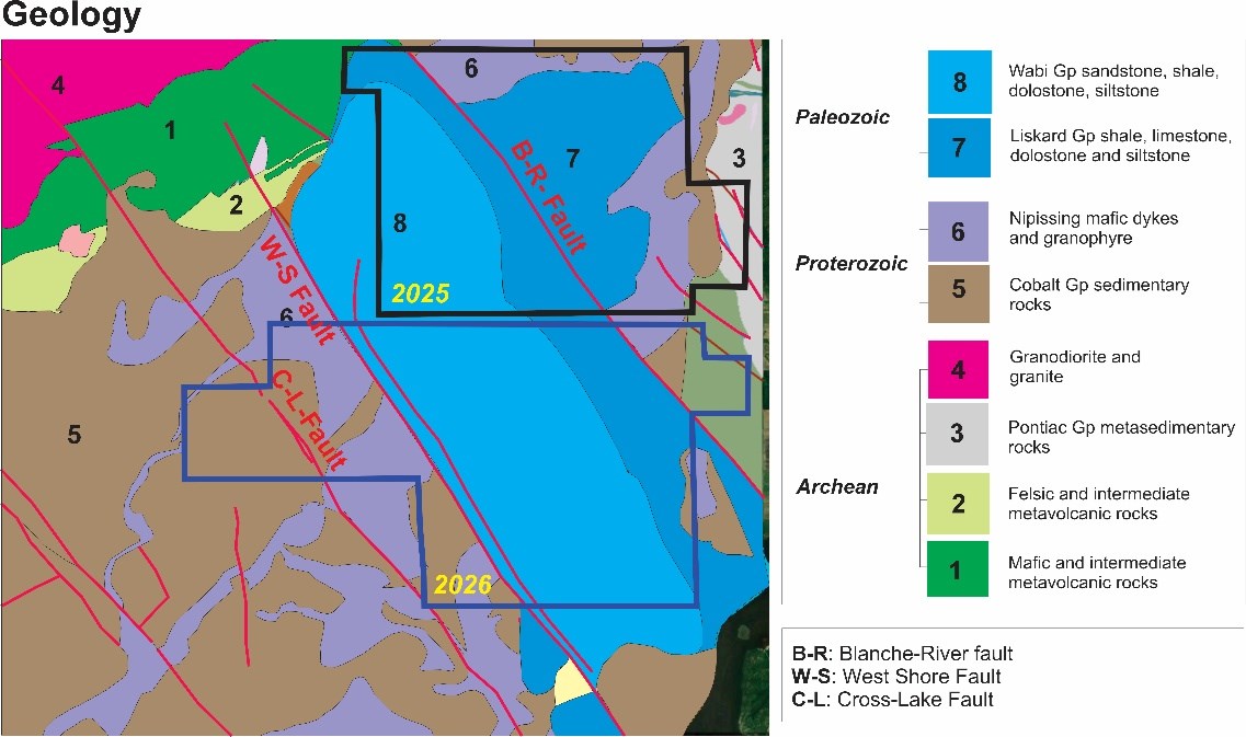
Figure 1. Simplified geological map redrawn from the OGS geological map available in KML format. Source: OGSEarth.
To view an enhanced version of this graphic, please visit:
https://images.newsfilecorp.com/files/7968/314746_bf60254df4aea9ee_001full.jpg
In addition to these Paleozoic rocks, the western part of the graben is marked by a greater thickness of Proterozoic sedimentary rocks of the Huronian Supergroup (Young et al., 2001; Long, 2004) and by the presence of a large volume of Nipissing dikes visible on both sides of the Paleozoic sedimentary basin (Fig. 1). In our R2G2 model, the presence of late mafic magmatic rocks (as documented in the Cumberland of Nova-Scotia) is significant, since seafloor hydrothermal alteration and regional metamorphism of older igneous rocks (e.g., Archean greenstone belts) destroy the olivine and pyroxenes capable of generating natural hydrogen. The emplacement of the Nipissing dikes, during a late intraplate hotspot event (more than 500 Ma after the greenstone belts), represents a major LIP (LIP: Large Igneous Province; Ernst and Buchan, 2004) event that left behind very large, and still well-preserved, volumes of igneous minerals and magmatic sulfide mineralization. The deep parts of the basement could contain sills rich in olivine cumulates capable of reacting with groundwater channeled through the graben's major faults.
Significance of the 2026 work program for natural hydrogen exploration:
The work, which will be carried out largely in the fall of 2026, is located south of the perimeter of the surveys carried out in 2025. More specifically, the surveys will be carried out in the areas of the municipalities of Thornloe, Hanbury, Dymond, Temiskaming Shore, Kerns, Kennebec and McCool (Fig. 2).
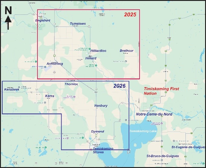
Figure 2. Location map showing the 2026 exploration program relative to the 2025 field work conducted by INRS and QIMC in the Témiscamingue graben
To view an enhanced version of this graphic, please visit:
https://images.newsfilecorp.com/files/7968/314746_bf60254df4aea9ee_002full.jpg
Soil-gas survey: The densification of the 2026 soil-gas survey aims to evaluate the role of faults in the western part of the graben in the mechanisms governing natural hydrogen emplacement within the graben, and to document the spatial distribution of hydrogen above the Paleozoic limestone zones that mark the areas of greatest subsidence in the graben.
Gravimetric survey: This geophysical survey, comprising more than 1,100 stations, will help detect the deepest depocenters of sedimentary rock accumulation and locate structural discontinuities between the Archean, Proterozoic, and Paleozoic blocks in the region (Fig. 1). These discontinuities could play a decisive role in transferring hydrogen from its deep sources to the subsurface. Given the high density of the Nipissing dikes relative to the Proterozoic and Paleozoic sedimentary rocks, the gravimetric data will help document spatial variations in dike thickness across the study area. On the Ontario side, the Nipissing dikes attest to the presence of large volumes of mafic magmatic rocks in the region (Fig. 1). These are continental tholeiites, rocks characterized by a very high FeO*/MgO ratio (Lightfoot et al., 1993). Olivine in equilibrium with this type of magma is consistently richer in Fe2+ than the olivine found in the MgO-rich, refractory dunitic rocks of ophiolites. The presence of significant volumes of olivine-rich magmatic rocks would therefore represent a potential hydrogen source. Under suitable temperature conditions and sufficient access to groundwater, this source could help explain the high hydrogen concentrations detected in soils (e.g. Zgonnik, 2020). In Témiscamingue, this hydrogen, generated by the alteration of Fe2+-rich minerals, could subsequently combine with radiolytic hydrogen produced by the interaction of groundwater with the potassium-rich sedimentary layers of the Huronian Supergroup, which are particularly thick on the Ontario side of the graben (Fig. 1).
Radiometric survey: The gamma mobile radiometric survey will help document the likely presence of redox halos associated with hydrogen transfer to the subsurface. Since potassium and thorium are sensitive to the hydrodynamic fractionation of sedimentary particles, gamma radiometry will also help refine soil characterization which is an important parameter in interpreting soil-gas survey data collected over different Quaternary substrates. In the western part of the study area (Kennebec, McCool), these measurements will help document the volumetric significance of potassium-rich arkosic sandstones in this sector, which has been intensely intruded by the Nipissing dikes.
Audiomagnetotelluric Survey (AMT): This natural-source electromagnetic method allows vertical penetration of the ground to a depth of roughly 1.5 km, making it possible to refine fault geometry at depth and document variations in the thickness of sedimentary rocks that unconformably overlie the Precambrian basement. 2D inversion of AMT data is essential to developing a coherent model capable of explaining the presence of natural hydrogen in the different sectors of the Témiscamingue Graben.
References:
Dix, G.R., Coniglio, M., Riva, J.F.V., et Achab, A., 2007. The Late Ordovician Dawson Point Formation (Timiskaming outlier, Ontario): Key to a new regional synthesis of Richmondian-Hirnantian carbonate and siliciclastic magnafacies across the central Canadian craton. Canadian Journal of Earth Sciences, v. 44, no. 9, p. 1313-1331.
Ernst, R.E., and Buchan, K.L., 2004. Igneous Rock Associations in Canada 3. Large Igneous Provinces (LIPs) in Canada and Adjacent Regions: 3 Ga to Present. Geoscience Canada, v. 31, no. 3.
Kumarapeli, P. S., 1985. The St. Lawrence rift system and its influence on the geological evolution of eastern North America. Geoscience Canada, 12 (2), 54-59.
Lightfoot, P.C., de Souza, H., and Doherty, W., 1993. Differentiation and source of the Nipissing Diabase intrusions, Ontario, Canada. Canadian Journal of Earth Sciences, v. 30, no. 6, p. 1123-1140.
Long, D.G.F., 2004. The tectonostratigraphic evolution of the Huronian basement and the subsequent basin fill: geological constraints on impact models of the Sudbury event. Precambrian Research, v. 129, no. 3-4, p. 203-223.
Russell, D.J., 1984. Paleozoic Geology of the Lake Temiskaming Area. Ontario Geological Survey, Preliminary Map P. 2700.
Young, G.M., Long, D.G.F., Fedo, C.M., and Nesbitt, H.W., 2001. Paleoproterozoic Huronian basin: product of a Wilson cycle punctuated by glaciations and a meteorite impact. Sedimentary Geology, v. 141-142, p. 233-254.
Zgonnik, V., 2020. The occurrence and geoscience of natural hydrogen: A comprehensive review. Earth-Science Reviews, 203, 103140.
ABOUT QUÉBEC INNOVATIVE MATERIALS CORP.
Québec Innovative Materials Corp. is a North American exploration and development company advancing a portfolio of natural hydrogen and critical mineral projects. The Company is advancing its district-scale hydrogen exploration model across Québec, Ontario, Nova Scotia and Minnesota, leveraging its proprietary R2G2™ framework.
QIMC is committed to responsible exploration, technical innovation and sustainable development, with the objective of supporting clean energy and decarbonization initiatives.
FOR FURTHER INFORMATION
QUÉBEC INNOVATIVE MATERIALS CORP.
John Karagiannidis
President & Chief Executive Officer
Email: info@qimaterials.com
Tel: +1 514-726-7058
Website: www.qimaterials.com
The Canadian Securities Exchange has not reviewed and does not accept responsibility for the adequacy or accuracy of the content of this news release.
FORWARD-LOOKING STATEMENTS
This news release contains certain forward-looking statements within the meaning of applicable Canadian securities legislation. Forward-looking statements include, but are not limited to, statements regarding the scope, timing, station counts and execution of the Company's 2026 Ontario exploration program; the planned engagement of the Timiskaming First Nation; the expected outputs of the soil-gas, gravimetric, gamma-ray spectrometric, radon-thoron and audiomagnetotelluric (AMT) survey methods discussed in this news release; the anticipated definition and ranking of drill targets; the potential design and acquisition of a future 2D seismic program in Ontario; the integration of Québec seismic results with Ontario datasets; and the Company's strategic plans and objectives.
Forward-looking statements are based on a number of assumptions, including, but not limited to, regulatory approvals and land access being obtained on a timely basis, the continued availability of financing, the availability of qualified contractors and field crews, favourable weather and ground conditions, favourable geological conditions, and the Company's ability to execute its exploration and development plans. Forward-looking statements are subject to known and unknown risks, uncertainties and other factors that may cause actual results, performance or achievements to differ materially from those expressed or implied by such statements. These risks and uncertainties include, among others, changes in regulatory requirements, delays in permitting, exploration risks, geological uncertainties, financing risks, market conditions, and general economic and business conditions.
Readers are cautioned not to place undue reliance on forward-looking statements. The Company undertakes no obligation to update or revise any forward-looking statements, except as required by applicable securities laws.
Soil-gas, radon-thoron, gravimetric and gamma-ray spectrometric surveys are near-surface, indirect exploration techniques. Soil-gas hydrogen concentrations reported in parts per million are screening-level measurements of gas in shallow soil horizons; they do not measure, and cannot be used to infer, subsurface hydrogen concentration, gas saturation, formation pressure, flow rate, deliverability, recoverable volumes or commerciality. Gravity, radiometric and radon data image geological structure and permeability pathways and do not detect hydrogen. Two-dimensional seismic data image subsurface architecture and likewise cannot establish the presence, concentration or recoverability of hydrogen.
Natural hydrogen is an emerging exploration play. There is no assurance that an economically recoverable natural hydrogen accumulation exists on any of the Company's Ontario, Québec or Nova Scotia properties, that any drill program will be undertaken or completed, or that any target generated by the 2026 program will be drilled. Station counts, line-kilometres, timing and scope of the program described in this news release are current plans and are subject to change based on weather, access, permitting, community engagement, contractor availability, financing and results as work progresses.
To view the source version of this press release, please visit https://www.newsfilecorp.com/release/314746