Vancouver, British Columbia--(Newsfile Corp. - May 13, 2026) - GREAT ATLANTIC RESOURCES CORP. (TSXV: GR) (the "Company" or "Great Atlantic") is pleased to provide an update regarding exploration progress at the Company's Pilley's Island Project in Pilley's Island, north-central Newfoundland, where HM Exploration Corp. holds an option to earn a 100% interest in the project through a combination of common share issuances and incurrence of exploration expenditures on the property, see Great Atlantic's September 29, 2025 news release for details. HM Exploration Corp. ("HM Exploration") has commenced diamond drilling at the project at the Clifford Jones (Bull Road) Trench Zone (the "Zone"). HM Exploration refers to their project area as the Lewis Pilley's Project (the "Project").
The drilling program (the "Program") is designed to test high-grade copper mineralization directly beneath surface samples collected by HM Exploration in 2025 that returned up to 16.6% copper*.
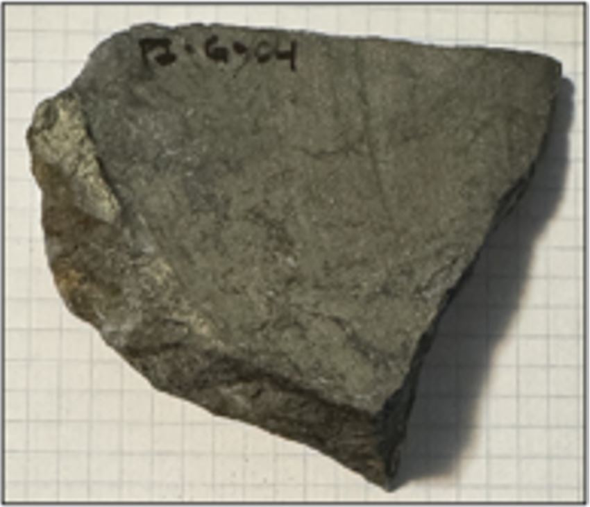
HM Exploration's 2025 Sample No. 181002 - 16.56% copper
To view an enhanced version of this graphic, please visit:
https://images.newsfilecorp.com/files/3027/297225_greatatlantic.jpg
"The massive sulfide exposed at surface at the Zone exhibits high grade copper content and is extensive," said Nicholas Rodway, CEO of HM Exploration. "The Zone we are currently drilling has not been historically tested. A 2016 trench uncovered the massive sulfide mineralization immediately southwest of prior drill holes, suggesting this zone was overlooked in earlier exploration campaigns. A high-grade, copper-rich intercept here would be transformative for the Company, particularly at this early stage of exploration. With recent exploration success in Newfoundland and increasing global focus on high-grade copper systems, we believe this represents a compelling opportunity for HM shareholders."
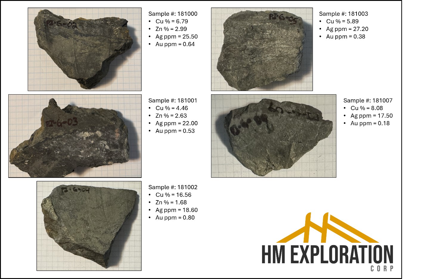
Figure 1: Outcrop samples collected at the Zone in 2025 displayed impressive mineralization including both massive and disseminated chalcopyrite ± sphalerite, silver, gold, and lead*.
To view an enhanced version of this graphic, please visit:
https://images.newsfilecorp.com/files/3027/297225_c601f923e4470acd_003full.jpg
Highlights:
- HM Exploration's diamond drilling program currently underway will be a two thousand five hundred (2,500) meters minimum.
- Drilling targeting high-grade mineralization beneath HM Exploration's surface samples grading up to 16.56% Cu*.
- 2025 outcrop grab samples taken by HM Exploration at the Zone returned*:
- Sample 181000 returned 6.79% Cu, 2.99% Zn, 22.50 g/t Ag, and 0.64 g/t Au
- Sample 181001 returned 4.46% Cu, 2.63% Zn, 22.00 g/t Ag, and 0.53 g/t Au
- Sample 181002 returned 16.56% Cu, 1.68% Zn, 18.60 g/t Ag, and 0.80 g/t Au
- Sample 181003 returned 5.89% Cu, 27.20 g/t Ag, and 0.38 g/t Au
- Sample 181007 returned 8.08% Cu, 17.50 g/t Ag, and 0.18 g/t Au
- Historic drilling conducted by Brinco-Getty and Brinex in the peripheral area produced assay values up to:
- BBF-27: 3.05m @ 0.93% Cu, 0.89% Pb, 3.51% Zn, 27.68 g/t Ag**
- PI-83-01: 7.35m @ 0.66% Cu, 0.51% Pb, 3.41% Zn, 10.57 g/t Ag**
- PI-83-07: 2.49m @ 0.70% Cu, 0.22% Pb, 0.74% Zn, 6.53 g/t Ag**
* Outcrop samples referenced above were collected in 2025 by the HM Exploration as part of HM Exploration's due diligence process prior to entering into the agreement to acquire the Project.
** Historic intercept lengths have been converted from feet to meters and Ag/Au results have been converted from oz/t to g/t.
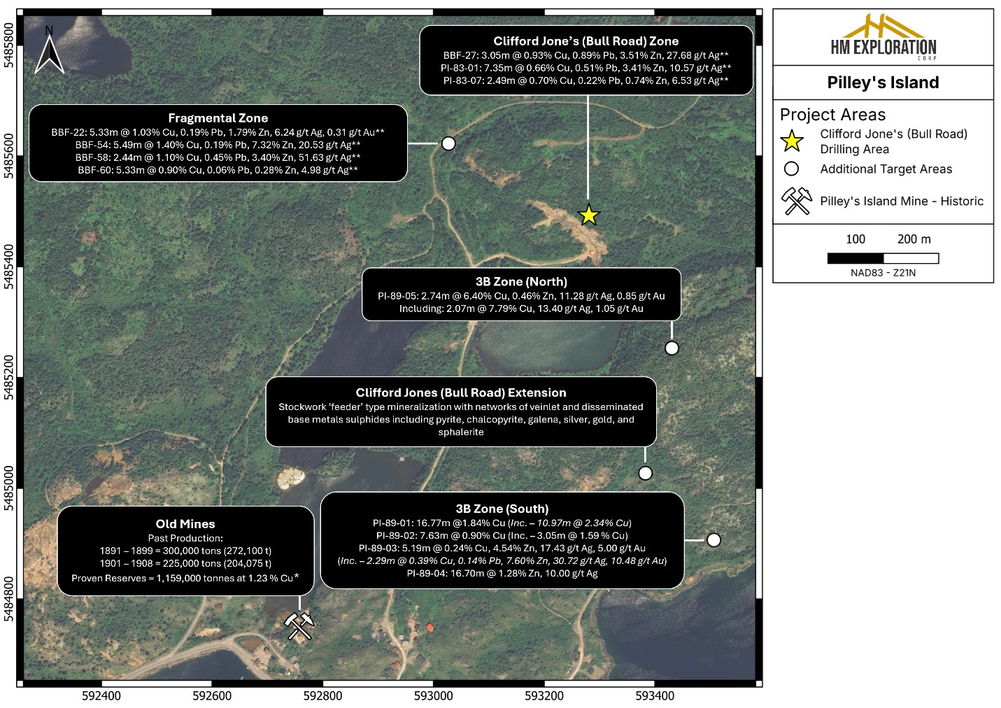
Figure 2: Location map of the Project displaying historical showings/zones located on the Project. 2026 diamond drilling has commenced at the Zone.
** Historic intercept lengths have been converted from feet to meters and Ag/Au results have been converted from oz/t to g/t.
To view an enhanced version of this graphic, please visit:
https://images.newsfilecorp.com/files/3027/297225_c601f923e4470acd_004full.jpg
About HM Exploration's Lewis Pilley's Project
The Project is road accessible and situated approximately twenty-five (25) km east of the town of Springdale, approximately fifty-five (55) km southeast of Firefly Metals' Green Bay Project and approximately a hundred fifty (150) km from the Pine Cove Mill and Port by way of major roads.
The Project has a long history of mining and exploration dating back to the late 1800's when the Pilley's Island Pyrite Company Ltd. produced approximately 450,000 tons of massive pyritic ore from the Pilley's Island Mine-Old Mines (after Kerr, 1996).
The Project hosts a cluster of Volcanogenic Massive Sulfide ("VMS") systems and prospects with demonstrated high-grade Zn-Pb-Cu-Ag+/-Au intersections. Mineralization is typical bimodal-felsic VMS, with both massive sulfide and sulfide-clast breccias (Thurlow, 2001). The geological setting is directly analogous to the Buchans camp (Thurlow, 1996), and the presence of sulfide-clast breccias is a strong vector toward proximal massive sulfide lenses.
Most of the historic showings that fall within the extents of the Project have not seen systematic exploration recently or historically. Many of the historic drill holes were shallow and drilled in a vertical orientation limiting the geological knowledge of the extents of the underlying lithology and mineralization. Work is being planned to validate historic assay results as well as collect new data from the 3B-Zone, Clifford Jones (Bull Road) Extension, Bouzanne Shaft, Henderson, Mansfield and Pilley's Cove Showings.
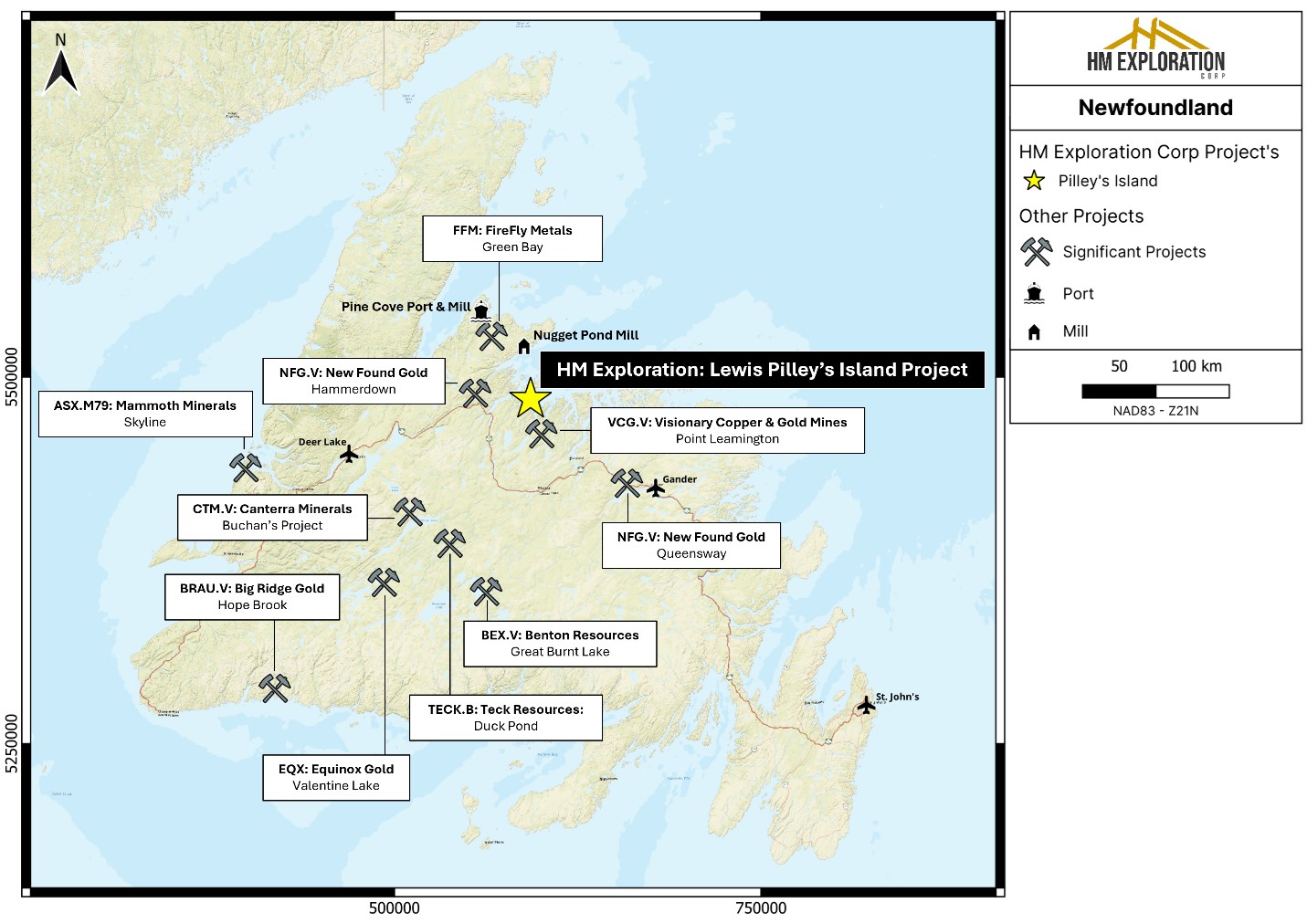
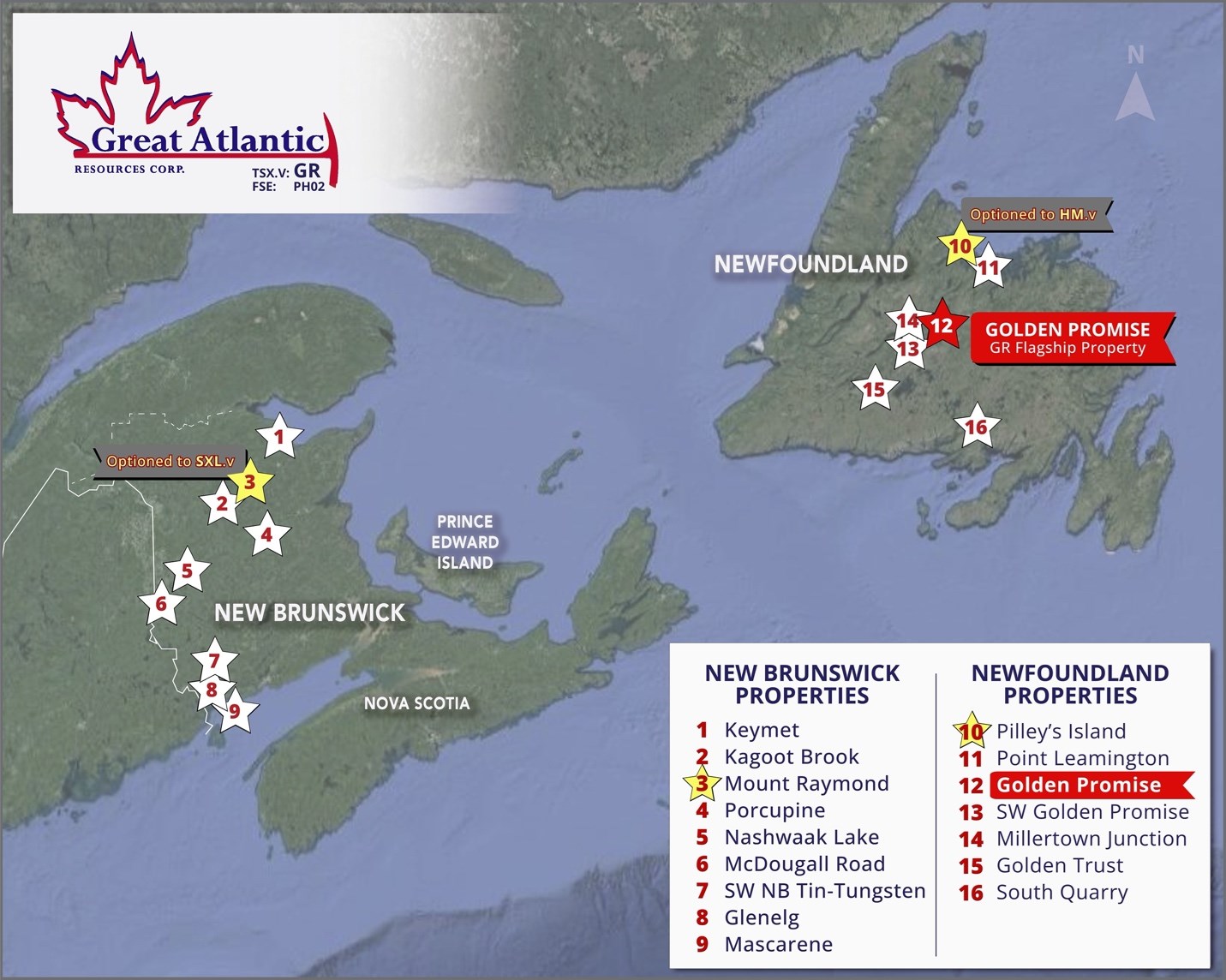
Figure 3: Regional map of Newfoundland displaying the location of the Project and other significant mineral exploration and mining projects in Newfoundland - Canada.
To view an enhanced version of this graphic, please visit:
https://images.newsfilecorp.com/files/3027/297225_c601f923e4470acd_005full.jpg
Geology & Mineralization
The Project is located within the Notre Dame Subzone of the Dunnage Tectonostratigraphic Zone. Of note, most of the Project is underlain by Ordovician submarine volcanic rocks of the Roberts Arm Group which is regionally identified as part of a mature arc sequence referred to as the Buchans-Roberts Arm Belt that also hosts the historic Buchan's mine (after Dunning et. Al., 1987). Mineralization occurs as lower grade (Spencer's Dock); medium grade (Old Mines); and high grade (3B-Zone/Clifford Jones) deposits that are of both sub-seafloor replacement and exhalative varieties. The deposits are often flanked by extensive chlorite, sericite, silica, K-feldspar and epidote alteration often observed in bimodal-felsic VMS systems. The Spencer's Dock area displays sericite/silica alteration that generally increases in intensity near mineralized zones, while the 3B/Old Mine areas display sericite/silica alteration that is abundant but less widespread and is more intense when proximal to mineralized zones (after Kerr, 1996).
VMS deposits are a globally significant source of copper, zinc, lead, silver, and gold. The Project's geology shares key characteristics with known VMS districts in Newfoundland, including the past producing Buchans, Ming and Rambler Mines supporting the exploration potential of the Project.
HM Exploration's Rock Sample Location Table
Table 1: Rock grab sample location table. Sample data points collected in NAD81 - Zone 21N.*
| Rock Sample - Locations | |||
| Sample # | East (UTM) | North (UTM) | Datum |
| 181000 | 593276.23 | 5485453.22 | NAD83 - Z21N |
| 181001 | 593273.84 | 5485455.64 | |
| 181002 | 593272.36 | 5485451.86 | |
| 181003 | 593273.92 | 5485454.92 | |
| 181004 | 593274.33 | 5485452.25 | |
| 181005 | 593273.69 | 5485453.48 | |
| 181006 | 593276.37 | 5485452.44 | |
| 181007 | 593275.54 | 5485453.11 | |
| 181008 | 593276.15 | 5485451.54 | |
| 181009 | 593273.92 | 5485451.94 | |
HM Exploration's Sampling, Preparation & QA/QC
Rock sample data points were collected using hand-held GPS (NAD83-Zone 21N).* The samples were given a unique sample ID and number and shipped directly to Eastern Analytical Ltd. (403 Little Bay Road, Springdale, NL), a commercial laboratory that is ISO/IEC 17025 accredited and completely independent of the company. Analytical methods include ICP-OES (34 element) with four-acid digestion, Au Fire Assay (30g) with AA finish, and Ore Grade Assay (multi-acid digestion) with AA finish.
References
British Newfoundland Exploration Limited 1968: Diamond drilling data from Pilley's Island, Newfoundland. British Newfoundland Exploration Limited Unpublished report [GSB# 002E/12/0168]
Bostock, H.H. 1988: Geology and petrochemistry of the Ordovician volcano-plutonic Roberts Arm Group, Notre Dame Bay, Newfoundland. Geological Survey of Canada Bulletin 369, 84 pages, with 1:50,000 colour map.
Consolidated Morrison Exploration Company 1979: The Bull Road showing, Pilley's Island, Nfld. Consolidated Morrison Exploration Company unpublished report. [NDNR 2E/12]
Dunning, G.R., Kean, B.F., Thurlow, J.G. and Swinden, H.S. 1987: Geochronology of the Buchans, Roberts Arm and Victoria Lake Groups and Mansfield Cove Complex, Newfoundland. Canadian Journal of Earth Sciences, Volume 24, pages 1175-1184.
Epp, W.R. 1984: Brinco/Getty Joint Venture Dawes Pond Tenure Pilley's Island 1984 diamond drilling report Blast Furnace Option, C.B. 2400, Lic. 2240, Newfoundland. Brinco Mining unpublished report. [NDNR 2E/524]
Grimley, P.H. 1968: Geological and other notes on Pilley's Island. Brinex unpublished report. [NDNR 2E12/274]
Harris, A. 1976: Consolidated Morrison Exploration Company; The Bull Road showing, Pilley's Island, Nfld. Consolidated Morrison Exploration Company unpublished report. [NDNR 2E/12/0388]
Horsburgh, J R 1967: The geology of the Pilley's Island prospect, Notre Dame Bay, Newfoundland. BSc thesis, Royal School Of Mines. 170 pages. [GSB# 002E/12/0265]
Hum, P. 1983: Report on the 1983 diamond drilling Pilley's Island Blast Furnace Option and C.B. 2400, License 2240, Newfoundland. Brinco Mining Document No. G83005. [NDNR 2E/487]
Kerr, A. (1996) New perspectives on the stratigraphy, volcanology, and structure of the island-arc volcanic rocks in the Ordovician Roberts Arm Group, Notre Dame Bay. In Current Research, Newfoundland Department of Natural Resources, Geological Survey, Report 96-1, pages 283-310.
Paltser, Ulo, 1989. Geological and geochemical surveys in the Sunday Cove Tickle area, north central Newfoundland, C.B. 5746, Lic. 3303, NTS 2E/12, by James Wade Engineering for Epoch Capital Corp. [2E/12/0648]
Strong, D F 1974: Geology of the Pilleys Island area. In Ore deposits and their tectonic setting in the Central Mobile Belt of northeast Newfoundland. Geological Association of Canada-Mineralogical Association of Canada, Field Trip Manual, No. A-3 and B-3, pages 26-34. [GSB# NFLD/0782]
Thurlow, J.G 1996: Geology of a newly discovered cluster of blind massive sulfide deposits, Pilley's Island, central Newfoundland. In Current Research, Newfoundland Department of Natural Resources, Geological Survey, Report 96-1, pages 181- 189.
Tuach, J. 1989: Diamond drilling at Pilley's Island, Newfoundland January - February 1989. Licence 2278 and Fee Simple Grant Vol. 1, Fol. 28 (NTS 2E/12). Au Pell Resources Inc. unpublished report. [ NDNR 2E/656]
Walker, W B G 1960: Report on copper-pyrite of Pilley's Island, Newfoundland. British Newfoundland Exploration Limited Unpublished report [GSB# 002E/12/0242]
HM Exploration's National Instrument 43-101 Disclosure
Nicholas Rodway, P.Geo, (Licence# 46541) (Permit to Practice# 1000359) is CEO and Director of the Company, and a qualified person as defined by National Instrument 43-101- Standards of Disclosure for Mineral Projects. Mr. Rodway has supervised the preparation, verified and approved the technical content in this news release. Verification included review of field notes, sample tags and analytical certificates. No limitations were noted during the verification process.
David Martin, P.Geo., (New Brunswick and Newfoundland and Labrador), a Qualified Person as defined by NI 43-101 and VP Exploration for Great Atlantic, reviewed and approved the technical information contained in this News Release. Great Atlantic has not verified HM Exploration's 2025 rock samples stated in this news release.
On Behalf of the board of directors
"Christopher R. Anderson"
Mr. Christopher R. Anderson
President CEO Director
604-488-3900
Investor Relations:
1-416-628-1560
IR@GreatAtlanticResources.com
___
Never miss an update!
Follow Great Atlantic Resources Corp. on social media for project updates, photos, and much more.
LINKEDIN: https://ca.linkedin.com/company/greatatlanticresources
X: https://x.com/GreatAtlRes
FACEBOOK: https://www.facebook.com/GreatAtlanticResources
INSTAGRAM: https://www.instagram.com/greatatlanticresources/
YOUTUBE: https://www.youtube.com/@GreatAtlanticTV/
TIKTOK: https://www.tiktok.com/@greatatlanticresources
To view an enhanced version of this graphic, please visit:
https://images.newsfilecorp.com/files/3027/297225_c601f923e4470acd_006full.jpg
About Great Atlantic Resources Corp.: Great Atlantic Resources Corp. is a Canadian exploration company focused on the discovery and development of mineral assets in the resource-rich and sovereign risk-free realm of Atlantic Canada, one of the number one mining regions of the world. Great Atlantic is currently surging forward building the company utilizing a Project Generation model, with a special focus on the most critical elements on the planet that are prominent in Atlantic Canada, Gold, Copper, Zinc, Nickel, Cobalt, Antimony and Tungsten.
To view an enhanced version of this graphic, please visit:
https://images.newsfilecorp.com/files/3027/297225_c601f923e4470acd_007full.jpg
This press release includes certain statements that may be deemed "forward-looking statements". All statements in this release, other than statements of historical facts, that address future exploration drilling, exploration activities and events or developments that the Company expects, are forward looking statements. Although the Company believes the expectations expressed in such forward-looking statements are based on reasonable assumptions, such statements are not guarantees of future performance and actual results or developments may differ materially from those in forward-looking statements. Factors that could cause actual results to differ materially from those in forward-looking statements include exploitation and exploration successes, continued availability of financing, and general economic, market or business conditions.
Neither TSX Venture Exchange nor its Regulation Services Provider (as that term is defined in the policies of the TSX Venture Exchange) accepts responsibility for the adequacy or accuracy of this release.
Great Atlantic Resource Corp.
888 Dunsmuir Street - Suite 888, Vancouver, B.C., V6C 3K4
![]()
To view the source version of this press release, please visit https://www.newsfilecorp.com/release/297225
Source: Great Atlantic Resources Corp.