Vancouver, British Columbia--(Newsfile Corp. - February 4, 2026) - Bayridge Resources Corp. (CSE: BYRG) (OTCQB: BYRRF) (FSE: O0K0) ("Bayridge" or the "Company") is pleased to provide an overview of its planned 2026 exploration program at the Baker Lake Uranium Project, located in Nunavut's Kivalliq Region. The planned program is designed to advance multiple priority uranium targets identified through historical exploration and modern airborne geophysical datasets.
The Baker Lake Uranium Project comprises a large, underexplored land package within the Thelon-Baker Basin, a region widely regarded as a geological analogue to Saskatchewan's Athabasca Basin. Uranium mineralization is hosted within Kazan Formation sandstones and structurally prepared corridors, comparable to those controlling mineralization at the Angilak Deposit. Basin-scale fluid pathways and structural controls are interpreted to have played a key role in localizing uranium mineralization within the district (Latitude Uranium Inc. & Atha Energy Corp., 2023; Miller, 2009).
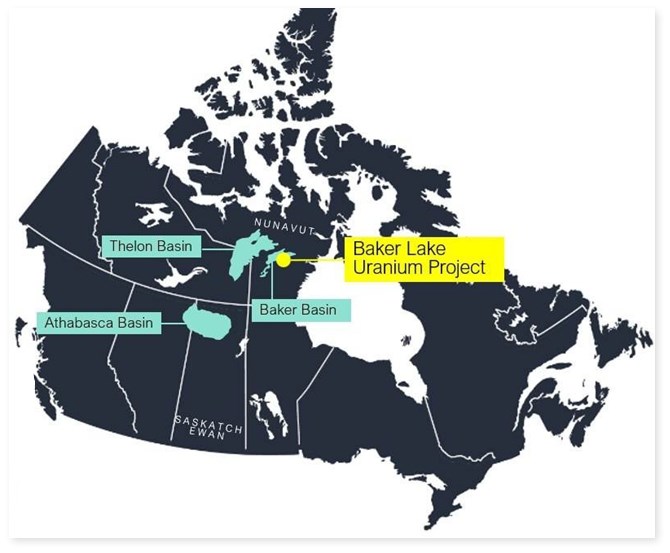
Figure 1: Baker Lake Uranium Project.
To view an enhanced version of this graphic, please visit:
https://images.newsfilecorp.com/files/10256/282641_e0f0fa84d4b9cae8_001full.jpg
Highlights
The Baker Lake Uranium Project is an advanced uranium project located in the Kivalliq Region of Nunavut located within the same Paleoproterozoic uranium district that hosts ATHA's Angilak and Orano's Kiggavik deposits.
The Project consists of 83 contiguous claims covering 619 km2
60 km South from the town of Baker Lake
$7 million in modern exploration value already completed
Strong geological parallels to Athas Angilak uranium camp
2008 TEMPEST® survey defined 30 high-priority uranium targets
Historical drilling returned multiple significant uranium intercepts
20 uranium prospects outlined along 70 km of the Baker Basin unconformity
Unexplored high-priority drill targets remain along untested EM conductors.
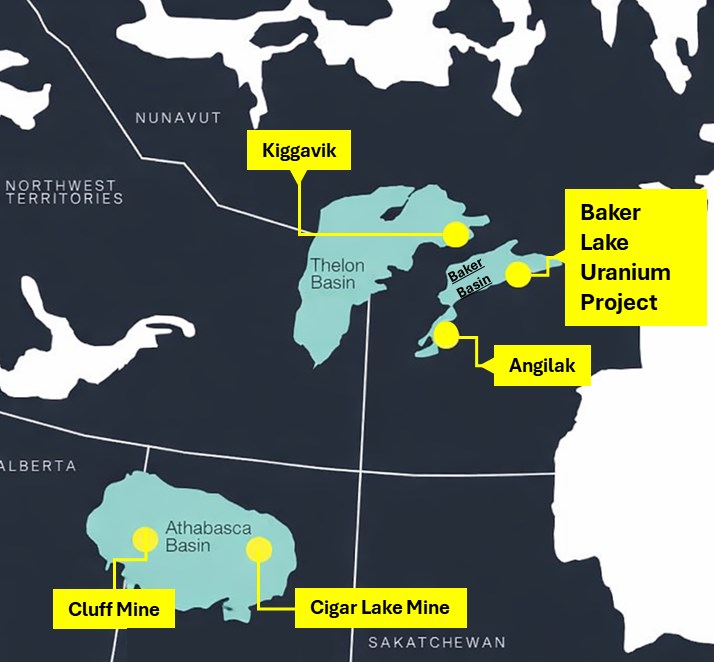
Figure 2: Property location, along with major uranium discoveries and operating mines in the geographical area.
To view an enhanced version of this graphic, please visit:
https://images.newsfilecorp.com/files/10256/282641_e0f0fa84d4b9cae8_002full.jpg
Exploration Strategy
The Company's exploration approach is focused on disciplined, phased advancement of targets, prioritizing areas with coincident structural complexity, conductive trends, and elevated uranium responses. Planned work will emphasize refining targets and reducing geological risk ahead of drilling.
Key elements of the planned exploration program include:
Program Highlights
Desktop review of all available historical exploration data
Reinterpretation of 2008 TEMPEST® airborne geophysical survey
Commencement of detailed geological mapping and prospecting over underexplored portions of the project area
Re-sampling of historical surface showings and priority targets
Re-logging of selected historic drill core to refine lithological, alteration, and structural interpretations
Advancement of logistics in preparation for a first-phase diamond drilling program
Drilling Program: Subject to permitting and early-stage results, a ~3,000 m helicopter-supported diamond drill program is planned to test priority uranium targets identified through historical data review and modern reinterpretation.
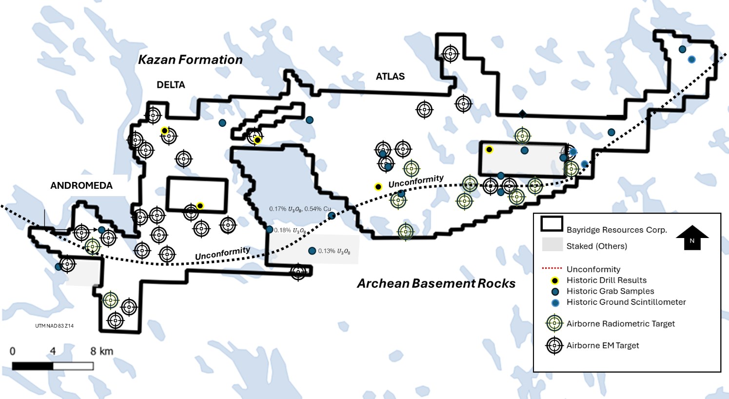
Figure 3: Property Map, along with airborne EM and radiometric targets.
To view an enhanced version of this graphic, please visit:
https://images.newsfilecorp.com/files/10256/282641_e0f0fa84d4b9cae8_003full.jpg
Mark Richardson, P.Geo., Vice President of Exploration, is the Qualified Person as defined by National Instrument 43-101 and has reviewed and approved the technical content of this release.
About Bayridge Resources Corp.
Bayridge Resources Corp. is a green energy company advancing a portfolio of Canadian uranium projects. Its flagship Baker Lake Uranium Project (51% interest) comprises 83 contiguous claims covering 619 km² in Nunavut's Kivalliq Region. Exploration has outlined a 75-km unconformity with multiple uranium targets supported by modern airborne geophysics and drilling.
ON BEHALF OF THE BOARD OF DIRECTORS:
For more information, please contact:
Saf Dhillon, President & Chief Executive Officer
E-mail: saf@bayridgeresources.com
Tel: 604-484-3031
Forward-looking information
This release contains statements and information that, to the extent that they are not historical fact, may constitute "forward-looking information" within the meaning of applicable securities legislation based on current expectations, estimates, forecasts, projections, beliefs and assumptions made by management of the Company. Forward-looking information is generally identified by words such as "believe", "project", "aim", "expect", "anticipate", "estimate", "intend", "strategy", "future", "opportunity", "plan", "may", "should", "will", "would", and similar expressions. Although the Company believes that the expectations and assumptions on which such forward-looking information are reasonable, undue reliance should not be placed on the forward-looking information because the Company can give no assurance that it will prove to be correct. Since forward-looking information addresses future events and conditions, by its very nature it involves inherent risks and uncertainties. Many factors could cause actual future events to differ materially from the forward-looking information in this news release. The forward-looking information included in this news release is expressly qualified by this cautionary statement. The forward-looking information contained in this news release is made as of the date hereof and the Company undertakes no obligation to update publicly or revise any forward-looking information, whether as a result of new information, future events or otherwise, unless so required by applicable laws.
The CSE has not reviewed, approved, or disapproved the contents of this press release.
Appendix
Historic Sampling, QAQC and Analytical Procedures
Pacific Ridge 2006 QA/QC and Analytical Procedures
In 2006, Pacific Ridge collected 209 surface samples and 200 drill core samples from the 694, KZ, and Lucky 7 zones. Samples were sealed, bagged, and shipped by air to Activation Laboratories (ActLabs), Ancaster, Ontario, an ISO-accredited facility. Surface samples weighed 3-5 kg; drill core was split into ~1 m intervals (~2.5 kg). QA/QC included blank Kazan arkose and quarter-core duplicates inserted at ~5% frequency. Core was scanned with an Exploranium GR-135 scintillometer prior to sampling. All samples were crushed and pulverized to -150 mesh and analyzed using Fusion XRF and Delayed Neutron Counting (DNC) for uranium, with select fire assay-AA analysis for gold. Thirteen pulp check samples (~7%) were sent to SRC for independent verification.
Source: Pacific Ridge Exploration Ltd., 2006 Exploration Report, Baker Basin Property.
Pacific Ridge 2007 QA/QC and Analytical Procedures
During the 2006-2007 work programs, 29 surface samples and 526 drill core samples were collected from the Lucky 7, Lucky 7 East, Area 8, and KZ zones. Samples were sealed, packed in rice sacks, and shipped by air to ActLabs, an ISO-registered laboratory. Core was split using a manual splitter into 0.5-1.0 m intervals. QA/QC included quarter-core duplicates inserted every ~20 samples (~4%) and blank Kazan arkose inserted every 10-20 samples (~5%). Core was scanned with an Exploranium GR-135 scintillometer prior to sampling. Samples were crushed to -150 mesh and analyzed by Fusion XRF and DNC for uranium, with select fire assay-AA for gold and silver. Thirty pulp check samples (~6%) were analyzed at SRC, returning results within ~5% of ActLabs values. All intervals represent core lengths; true widths are unknown.
Source: Pacific Ridge Exploration Ltd., 2007 Exploration Report, Baker Basin Property.
Drill Collar Table - 2006 Pacific Ridge Exploration Drilling Campaign
| Zone | Hole ID | Northing (UTM) | Easting (UTM) | Length (m) | Azimuth (°) | Dip (°) | |||
| 694 | 694-06-01 | 7,065,052 | 363,139 | 123.44 | 90 | -45 | |||
| 694 | 694-06-02 | 7,065,052 | 363,138 | 136.86 | 90 | -75 | |||
| 694 | 694-06-03 | 7,065,138 | 363,119 | 68.58 | 90 | -45 | |||
| 694 | 694-06-04 | 7,065,138 | 363,118 | 121.31 | 90 | -70 | |||
| 694 | 694-06-05 | 7,065,175 | 363,057 | 93.06 | 90 | -55 | |||
| 694 Subtotal | - | - | - | 543.25 | - | - | |||
| KZ | KZ-06-01 | 7,079,071 | 372,753 | 148.57 | 282 | -45 | |||
| KZ | KZ-06-02 | 7,079,071 | 372,753 | 168.25 | 282 | -70 | |||
| KZ | KZ-06-03 | 7,079,071 | 372,754 | 55.17 | 180 | -45 | |||
| KZ | KZ-06-04 | 7,079,065 | 372,768 | 180.87 | 287 | -70 | |||
| KZ | KZ-06-05 | 7,079,118 | 372,767 | 179.22 | 287 | -75 | |||
| KZ | KZ-06-06 | 7,079,069 | 372,784 | 317.14 | 282 | -80 | |||
| KZ Subtotal | - | - | - | 1,049.22 | - | - | |||
| Lucky 7 | L7-06-01 | 7,078,202 | 382,264 | 85.59 | 235 | -50 | |||
| Lucky 7 | L7-06-02 | 7,078,202 | 382,264 | 139.6 | 235 | -66 | |||
| Lucky 7 | L7-06-03 | 7,078,202 | 382,264 | 158.19 | 235 | -80 | |||
| Lucky 7 Subtotal | - | - | - | 383.38 | - | - | |||
| Total Drilled (2006) | - | - | - | 1,969.50 m | - | - | |||
Source: Pacific Ridge Exploration Ltd. (2006), Baker Basin Exploration Report.
Drill Collar Table - 2007 Pacific Ridge Exploration Drilling Campaign
| Zone | Hole ID | Northing (UTM) | Easting (UTM) | Depth (m) | Azimuth (°) | Dip (°) | |||
| Lucky 7 | L7-07-04 | 7,078,213 | 382,290 | 237.1 | 237 | -66 | |||
| Lucky 7 | L7-07-05 | 7,078,227 | 382,317 | 459.6 | 245 | -66 | |||
| Lucky 7 | L7-07-06 | 7,078,243 | 382,342 | 450.2 | 236 | -66 | |||
| Lucky 7 | L7-07-07 | 7,078,253 | 382,374 | 736.4 | 236 | -66 | |||
| Lucky 7 | L7-07-08 | 7,078,172 | 382,316 | 282.5 | 236 | -60 | |||
| Lucky 7 | L7-07-09 | 7,078,128 | 382,339 | 276.5 | 236 | -60 | |||
| Lucky 7 | L7-07-10 | 7,078,128 | 382,339 | 378.6 | 236 | -71 | |||
| Lucky 7 Subtotal | - | - | - | 2,820.90 | - | - | |||
| KZ | KZ-07-07 | 7,079,055 | 372,817 | 306.9 | 282 | -66 | |||
| KZ | KZ-07-08 | 7,079,055 | 372,817 | 450.4 | 282 | -75 | |||
| KZ Subtotal | - | - | - | 757.3 | - | - | |||
| Total Drilled (2007) | - | - | - | 3,578.20 m | - | - | |||
References
Latitude Uranium Inc., & Atha Energy Corp. (2023). NI 43-101 technical report on the Angilak Project, Nunavut, Canada (effective date: March 31, 2023). Prepared by: Robert Sim, P.Geo., and William Lewis, P.Geo., Micon International Limited. 293 p.
Fugro Airborne Surveys. (2008). Baker Basin airborne geophysical survey report: TEMPEST® EM, magnetics, and gamma-ray spectrometry for Aurora Energy Resources Inc. Prepared for Aurora Energy Resources Inc.
Pacific Ridge Exploration Ltd. (2007). 2006 exploration report on prospecting, radiometrics and drilling, Baker Basin property, Kivalliq Region, Nunavut (pp. 1-68). Pacific Ridge Exploration Ltd.
Pacific Ridge Exploration Ltd. (2008). 2007 Baker Basin exploration report: Drilling, prospecting, geological mapping, and radiometric surveying, Kivalliq Region, Nunavut (pp. 1-82). Pacific Ridge Exploration Ltd.
Miller, A. R. (1980). The Baker Lake Basin: Stratigraphy, structure and uranium potential of a Paleoproterozoic basin in Nunavut, Canada (Master's thesis). University of Alberta.
![]()
To view the source version of this press release, please visit https://www.newsfilecorp.com/release/282641
Source: Bayridge Resources Corp.