
Oct 25, 2023
On August 30 2021, Zoom Video Communication's stock price plunged 17% following one of its earnings calls in Q2.
Thunder Bay, Ontario--(Newsfile Corp. - June 9, 2022) - Metals Creek Resources Corp. (TSXV: MEK) (OTCQB: MCREF) (FSE: M1C1) (the "Company" or Metals Creek) is pleased to announce additional diamond drill results from drill holes DL22-029, 030 and 031 of the phase III diamond drill program at the Dona Lake Gold project (See News Release November 08, 2021).
Hole DL22-029 continues to demonstrate the continuation of high-grade gold mineralization within the main zone stratigraphy, below the 455 level of the past producing Dona Lake Gold mine (See Figure 1, Schematic Long Section and Figure 2, Schematic X-Section). Hole 029 intersected the Main Zone stratigraphy 499 meters below surface and returned a core length intercept of 11.80 grammes per ton (g/t) gold (Au) over 3.66 meters(m) (539.47-543.13m). This was a part of a broader zone of mineralization of 6.38 g/t Au over 11.33m (531.80-543.13m). Mineralization was hosted within a silicate sulfide iron formation with 0.5 to 25% pyrrhotite and local pyrite with associated grunerite and garnets. Visible gold was noted in this intercept. A second zone of mineralization was intercepted 516m below surface, which returned a core length intercept of 36.21 g/t Au over 2.47m, (558.63-561.10m). This second zone of mineralization is also within the main zone stratigraphy and is separated from the noted intercept above by 11m of felsic dike material. It is hosted within a moderately foliated and chloritized iron formation with 1-20% pyrrhotite and 2-10% pyrite. Visible gold was also noted in this intercept.
A third zone of high-grade gold mineralization was intercepted 54m east (in the hanging-wall) of the main zone iron formation within quartz stockwork returning a grade of 67.10 g/t Au over 0.28m (470.35-470.63m) (See Figure 2, Schematic X-Section). This high-grade veining was intercepted 435m below surface and is hosted within sheared mafic volcanic adjacent to an intermediate dike. Significant visible gold (30 specks) was observed in association with moderate alteration consisting of sericite and 1-2% disseminated pyrite.
Select pieces of drill core from DL22-029 will be available for viewing at MEK booth # 2640 during PDAC, 13-15 June, 2022 .
Two additional holes were drilled testing peripheral iron formations outside the Dona Lake mine stratigraphy. These holes were planned to better define the orientation and composition of these iron formations. Hole DL22-030 tested the northwest iron formation (See attached Figure 3, Drill Hole location map) returning a core length intercept of 0.66 g/t Au over 9.10m (71.00-80.10m). Mineralization was hosted within silicate-oxide iron formation with trace to 3% pyrrhotite. Hole DL22-031 returned no significant results (NSA) within a chert rich iron formation with local seams of massive pyrrhotite. This hole was drilled east of the Dona Lake mine.
The phase III diamond drill program has successfully defined additional high-grade gold mineralization south of the Dona Lake mine workings. Deeper drilling targeting stratigraphy below the lowermost mine workings has extended high-grade gold mineralization down plunge to a vertical depth of 753m (See news release April 5, 2022). Recently reported drill hole DL22-025 returned a high-grade down hole intercept of 8.11 g/t over 9.51m. This hole represents the deepest hole to date on the Dona Lake property with gold mineralization remaining open at depth.
| Drill Hole Number | From (m) | To (m) | Total (m) | Grammes Per Ton Gold | Remarks |
| DL22-029 | 470.35 | 470.63 | 0.28 | 67.10 | New Qtz Vein |
| and | 531.80 | 543.13 | 11.33 | 6.38 | Main Zone |
| Including | 539.47 | 543.13 | 3.66 | 11.80 | Main Zone |
| and | 558.63 | 561.10 | 2.47 | 36.21 | Main Zone |
| DL22-030 | 71.00 | 80.10 | 9.10 | 0.66 | NW Iron Formation |
| DL22-031 | NSA | East Iron Formation |
Table 1 - Significant Results

Figure 1 Schematic Longitudinal
To view an enhanced version of this graphic, please visit:
https://orders.newsfilecorp.com/files/943/127066_a8a20679f4ff7a0c_003full.jpg
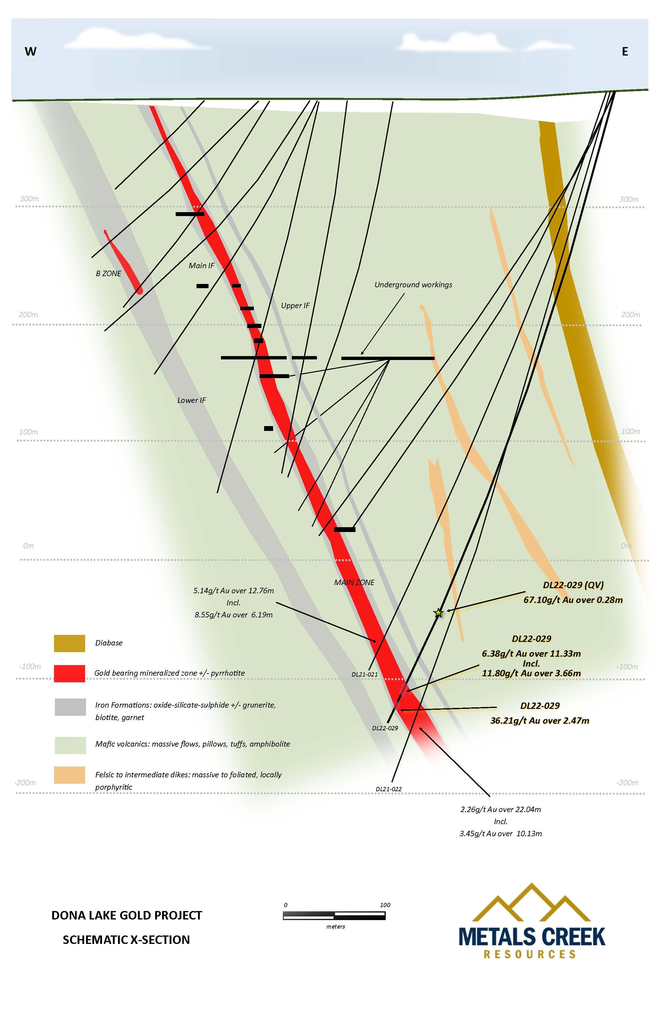
Figure 2 Schematic Cross-section
To view an enhanced version of this graphic, please visit:
https://orders.newsfilecorp.com/files/943/127066_a8a20679f4ff7a0c_004full.jpg

Figure 3 Drill Hole location Map
To view an enhanced version of this graphic, please visit:
https://orders.newsfilecorp.com/files/943/127066_a8a20679f4ff7a0c_005full.jpg
True thickness is 70-80% of drill intercept length.
The Dona Lake Gold Project was optioned from Newmont Corporation (previously Newmont Goldcorp - see news release dated 13 June 2019) and is located in the Pickle Lake Greenstone Belt which is host to several historic mines including the Dona Lake mine, the Central Patricia mine and the Pickle Crow mine. Dona Lake is accessible by an all-weather road southeast from the Town of Pickle Lake. The Project consists of 32 patented and leased mining claims and 35 map staked claims totaling approximately 1,122 hectares and covers the past producing Dona Lake Mine.
Michael MacIsaac, P.Geo and VP Exploration for the Corporation and a qualified person as defined in National Instrument 43-101, is responsible for this release, and supervised the preparation of the information forming the basis for this release.
All split core samples were sent to Activation Laboratories. The precious metals were analyzed utilizing a standard fire assay with an atomic absorption finish. As part of the Corporations QAQC protocol, approximately 10% of the samples submitted for assay were also sent for check assays. Standards and blanks were inserted randomly into the sample shipments as part of the sampling protocol. Samples with fire assay results above 1.0 g/t gold are re-analyzed using a gravimetric finish and samples with fire assay results above 5.0 g/t gold or samples showing visible gold are analyzed using the pulp metallic method.
About Metals Creek Resources Corp.
Metals Creek Resources Corp. is a junior exploration Company incorporated under the laws of the Province of Ontario, is a reporting issuer in Alberta, British Columbia and Ontario, and has its common shares listed for trading on the Exchange under the symbol "MEK". Metals Creek has earned a 50% interest in the Ogden Gold Property from Newmont Corporation, including the former Naybob Gold mine, located 6 km south of Timmins, Ontario and has an 8 km strike length of the prolific Porcupine-Destor Fault (P-DF). In addition, Metals Creek has signed an agreement with Newmont Corporation,
where Metals Creek can earn a 100% interest in the past producing Dona Lake Gold Project in the Pickle Lake Mining District of Ontario.
Metals Creek also has multiple quality projects available for option in Ontario and Newfoundland which can be viewed on the Corporation's website. Parties interested in seeking more information about properties available for option can contact the Corporation at the number below.
Additional information concerning the Corporation is contained in documents filed by the Corporation with securities regulators, available under its profile at www.sedar.com.
Neither the TSX Venture Exchange nor its Regulation Services Provider (as that term is defined in the policies of the TSX Venture Exchange) accepts responsibility for the adequacy or accuracy of this release.
Alexander (Sandy) Stares, President and CEO
Metals Creek Resources Corp
telephone: (709)-256-6060
fax: (709) -256-6061
email: astares@metalscreek.com
www.MetalsCreek.com
Twitter.com/MetalsCreekRes
Facebook.com/MetalsCreek
![]()
To view the source version of this press release, please visit https://www.newsfilecorp.com/release/127066

Analyst, journalist, or company stakeholder? Sign up to receive news releases by email for Metals Creek Resources Corp. or all companies belonging to the Mining and Metals, Precious Metals industries.