


SPATIAL PREDICTIVE TECHNOLOGY
Determine the location of any distant object
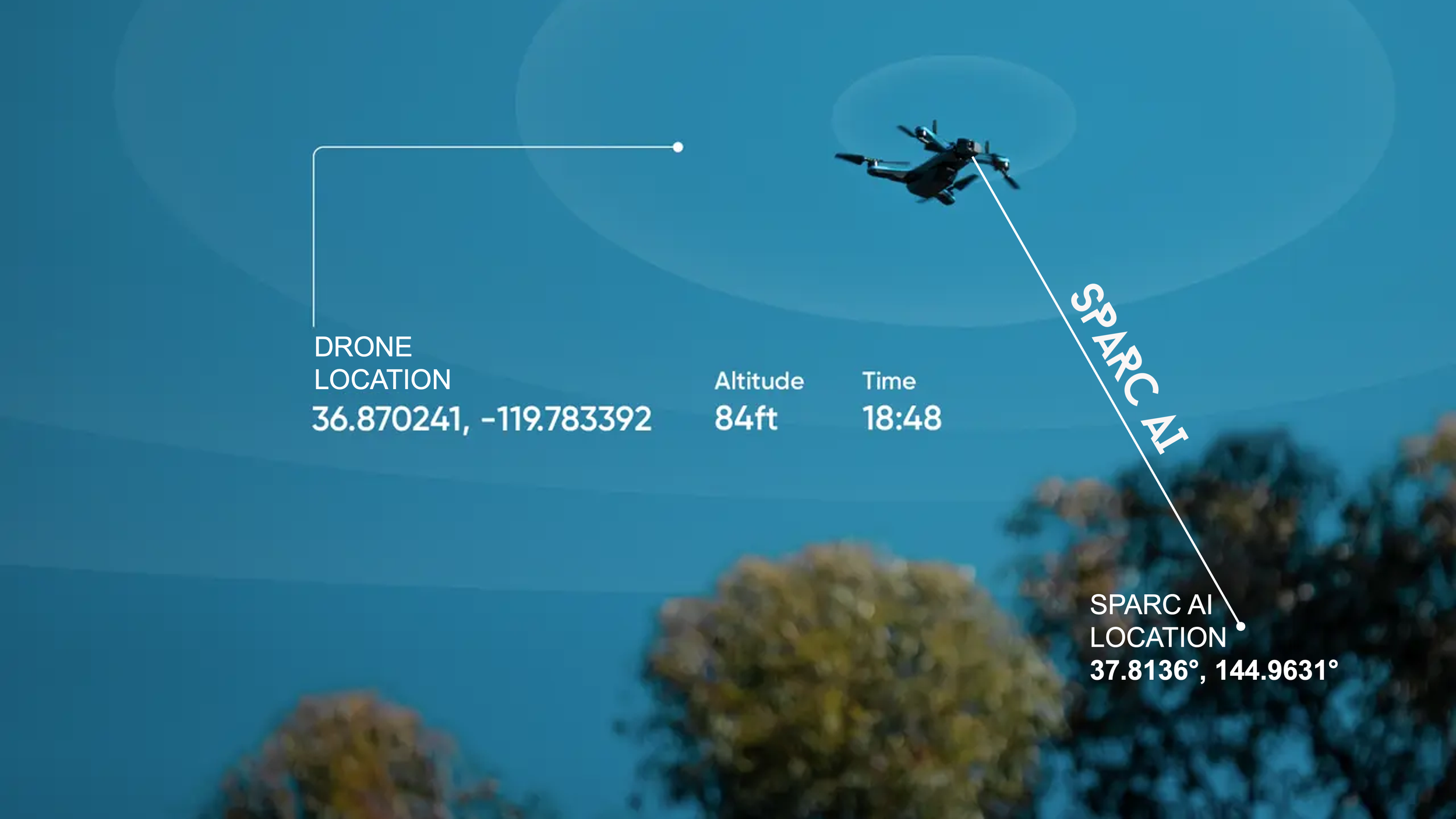
Determining the location of a drone is easy, but determining the location of a distant object that is 100 miles away is a challenge.
Using patented technology, SPARC AI can determine the location of any distant object without the use of the internet, GPS or satellite.
Using proprietary and patented algorithms, SPARC AI can be installed on any camera device or sensor.
It is also 100% covert which is ideal for military, surveillance, target acquisition, asset protection, and situational awareness.
The technology is lightweight and can be installed on any camera device from drone cameras to large surveillance systems.

Location Reverse Lookup
An image taken using SPARC AI will have an embedded proprietary patented algorithm in the image for Location Reverse Lookup.
A user or agent can click anywhere on the image pixel and SPARC AI will instantly provide the geolocation of the pixel in the image.
This powerful feature provides flexibility and ability to build proprietary maps of objects for surveillance, and situational awareness that benefits commercial, military and insurance use cases.
Also, imagine clicking on an image pixel that automatically sends a drone directly to a SPARC AI location.

Create a Geofence
Using a drone or a series of fixed cameras to capture a geofenced area of reference. Use the area of the polygon and the x,y,z bounding points for situational awareness, surveillance, asset protection and tracking targets of interest.
Use AI and machine learning to capture data over time and integrate 3rd party data for intelligence data analysis.

Virtual Triangulation
Select from a series of cameras to determine the optimal line of slight to the point of interest.
The optimal camera view is identified and displayed to the user.
The point where the camera views or trajectories intersect on the electronic topographic map can be calculated and displayed.

Extend the “Range”
Various factors determine how far a drone can fly including the drone's battery life, the strength of its transmission system, the amount of lift it can generate, as well as weather conditions along its flight path.
SPARC AI allows you to capture the location of any distant object.
This capability allows drones to survey points of interest that are well beyond their distance range limits.

ChatGPT
Integrate SPARC AI into your proprietary applications, or pull data from third party sources to query SPARC AI data to build highly sophisticated and intelligent geolocation solutions.
Collect large datasets of information from drone or fixed camera locations with SPARC AI and use ChatGPT and natural language protocols to query your proprietary location data for instant analysis and response.

7 Patents - How it Works
SPARC AI has registered patents in the United States, Canada, Japan, South Korea, China, Australia, and New Zealand.
The registered patents include a set of proprietary algorithms that calculates a camera xyz coordinates combined with the earth’s terrain model to predict the location of distant objects that may be hundreds of meters away.
The technology is covert and lightweight and can be installed on any camera device from drone cameras to large surveillance systems.