Solis Minerals: Project Tenements Granted at Cinto
October 12, 2022 9:24 AM EDT | Source: Solis Minerals Ltd.
- Seven tenements granted in the highly prospective southern Peruvian Copper belt, southeast of world class Toquepala Au/Ag/Cu/Mo Porphyry Mine.
- Solis' new Cinto Project straddles the regional scale Incapuquio Fault system, and is interpreted to be similar rocks that host Toquepala, 15km to the northwest.
- Worldview-3 remote sensing data and alteration interpretation being completed over key Solis' Peruvian projects - indentifying new drill targets at Ilo Este.
- Field check of highlighted anomalies and detailed geological mapping to commence immediately in preparation for drill testing.
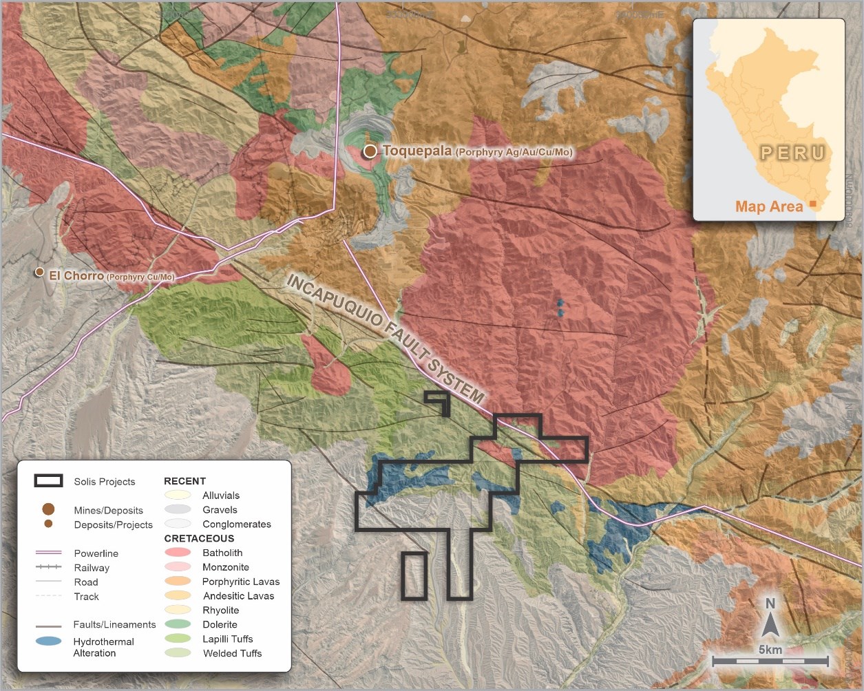
Vancouver, British Columbia--(Newsfile Corp. - October 12, 2022) - Solis Minerals Ltd. (ASX: SLM) (TSXV: SLMN) (FSE: 08W) ("Solis Minerals" or "the Company") is excited to announce it has received confirmation of grants for a series of largely contiguous tenements totalling 3,200ha in the highly prospective southern Peruvian Copper belt, located some 15km to the southeast of the world class Toquepala Au/Ag/Cu/Mo Porphyry Mine (Figure 1 and Appendix 1). The new project will be called the Cinto Project.
The Company has completed the initial compilation of available geological and other data sets over the area, including the acquisition of new remote-sensing satellite data (comprising the Worldview-3[1] platform, amongst others) covering Cinto and Solis' other Peruvian copper projects. Specialist consultant interpretation of this new satellite data has highlighted several priority zones of favourable alteration - particularly at Ilo Este- which has never been tested. Field geological teams will mobilise shortly to undertake detailed field checking, mapping and systematic sampling of the highlighted alteration anomalies in preparation for drill testing. Detailed Worldview-3 data has been acquired over Cinto and is being processed.
CEO Jason Cubitt commented:
"This is an exciting development for Solis shareholders as the Cinto Project offers an opportunity to be the first exploration company to use modern exploration techniques on a staked area, located near one of Peru's largest copper producers, Toquepala mine[2]. With the same major structural controls, and similar rock type and age to Toquepala (57 Ma - 57 million years), we intend to advance this project to a drill-ready stage and offer Solis shareholders exposure to another world-class target in Peru's Southwest copper belt. The Company remains fully funded for this year's field season."

Figure 1: Cinto Project - Regional geology and Project location
To view an enhanced version of this graphic, please visit:
https://images.newsfilecorp.com/files/1134/140273_2c07ab0d1483ea0f_001full.jpg
Cinto Copper Project
The northern permits are underlain by igneous rocks of the Cretaceous Toquepala Group and the late Cretaceous-early Tertiary batholith related to the Toquepala porphyry mine some 15km to the northwest.
The regional Incapuquio fault crosses the permits and the underlying igneous rocks are covered by recent sediments, generally south of the fault and increasing in thickness to the southwest.
Several zones of hydrothermal alteration in the concessions are noted in published geological maps. The Company has recently acquired Worldview-3 satellite imagery to assist in rapid delineation of priority areas which will be followed up with geological mapping and rock sampling. The satellite data is currently being processed. Potential drill target identification would initiate permit applications for first-pass drill programs.
Ilo Este Copper Project
The Ilo Este (east) Project comprises four contiguous tenements covering an area of approximately 3,200ha (Figure 2). They are located about 110km northwest of the town of Tacna (Appendix 1).

Figure 2: Ilo Este Project - Tenure and Project location
To view an enhanced version of this graphic, please visit:
https://images.newsfilecorp.com/files/1134/140273_2c07ab0d1483ea0f_002full.jpg
Exploration undertaken by previous owners at Ilo Este included 12 reverse circulation (RC) drill holes (2000) and 12 diamond drill holes (2014-16), which were successful in identifying copper-gold mineralisation and interpreted to be part of a Cu-Au porphyry system. Mineralisation is differentiated into two types:
1) Oxide zone - green copper oxide minerals (brocanite, atacamite, malachite, neocite, hematite and manganese oxides) with carbonate staining that occurs across both the southern and northern intrusion belts and occurring to depths of approximately 80m.
2) Hypogene mineralisation - copper sulphides (chalcopyrite-bornite-pyrite) occur as disseminations, in fractures and within quartz veins that occur as a random stockwork within porphyritic granodiorite and porphyritic quartz diorite of the northern intrusive belt.
Although it is thought that the parts of llo Este porphyry system may have been deeply eroded down to the potassic zone, there remains the potential to discover higher grade mineralisation in areas of the porphyry that have been less eroded as well as a lower-grade orebody within the remnants of the porphyry. There is also potential for the intrusive belts to continue under cover to the south and east and to have been offset by a major fault (the Chololo Fault) striking to the northeast that could have offset the upper portion of the porphyry. This upper part could potentially host a higher grade phyllic zone of mineralisation.

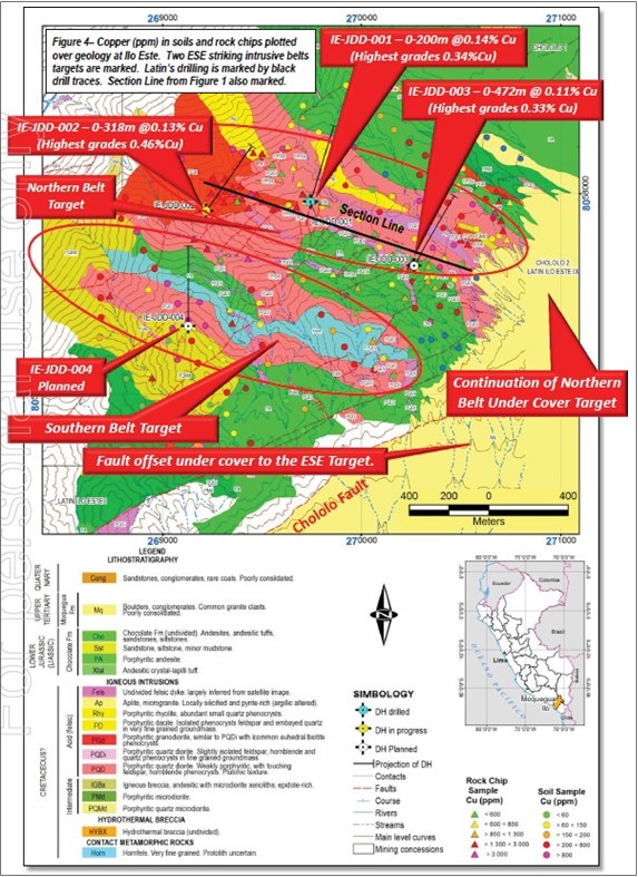
Figure 3: Map of the Ilo Este Copper Project showing geological mapping, geochemical surface sampling and drill hole collars and traces. (Source: Latin Resources Limited ASX release dated 3 February 2015; Copper Mineralisation Confirmed over 1.1km of Strike at Ilo Este Copper Porphyry)
To view an enhanced version of this graphic, please visit:
https://images.newsfilecorp.com/files/1134/140273_2c07ab0d1483ea0f_003full.jpg
The Company has recently undertaken Worldview-3 satellite imagery studies and is interpreting the data. Based on initial results indicating untested alteration, it is envisaged that further areas for exploration north of the Chololo fault (Figure 4) will be subject to geological ground mapping, rock sampling, and renewed alteration domain interpretation. South of the Chololo fault, in areas of recent geological cover, a ground magnetic geophysical survey will be undertaken in areas viewed to contain favourable underlying structural architecture to host porphyry-style intrusives. These programs, combined with data from previous drilling, will allow drill planning to proceed in the coming months and permitting to be initiated.

Figure 4: Ilo Este map of simplified geology: Blue - Jurassic intrusives/volcanics, Red - Cretaceous Batholith, Stippled - Tertiary cover, Green - Quaternary cover
To view an enhanced version of this graphic, please visit:
https://images.newsfilecorp.com/files/1134/140273_2c07ab0d1483ea0f_004full.jpg
Ilo Norte Copper Project
The Ilo Norte Project area (Figure 5) consists of eight Mining Concessions covering a total area of 7,700ha approximately 20km northeast from the Pacific coastal town of Ilo, in the Ilo Province, Department of Moquegua of Sothern Peru (Appendix 1).

Figure 5: Ilo Norte Project - Tenure and Project location
To view an enhanced version of this graphic, please visit:
https://images.newsfilecorp.com/files/1134/140273_2c07ab0d1483ea0f_005full.jpg
The geology of the llo Norte Project area consists of andesitic pyroclastics, andesitic volcanics belonging to the Chocolate Formation and younger Quaternary cover sediments (Figure 6 and Appendix 1).
Exploration undertaken by previous owners at Ilo Norte included eight RC holes (2011) and 16 diamond holes (2014). Mineralisation encountered at llo Norte is interpreted to be part of an IOCG-type deposit contained within the highly altered andesitic volcaniclastics of the Chocolate Formation. Contact metamorphism and metasomatism have produced at least five phases of widespread development of mostly lentiform economic mineral assemblages including copper, gold, silver, zinc and minor cobalt.

Figure 6: Ilo Norte Project (western part) -Project geology and historical drill collar locations: (Source: NI43-101 Technical Report: Ilo Norte and Ilo Este projects, Griffin 2017). Notes: Orange hashed area indicates potential skarn alteration zone. Red stippled area represents silica-albite alteration
To view an enhanced version of this graphic, please visit:
https://images.newsfilecorp.com/files/1134/140273_2c07ab0d1483ea0f_006full.jpg
The Company is planning to acquire Worldview-3 satellite data at Ilo Norte in the coming months when climatic conditions are more favourable. This will augment the planning of the exploration programs which will be principally based around extending ground magnetics surveys over cover, and IP surveys where geological and access condition allow in the west of the area. This data, combined with previous drill results and structural interpretation, is expected to assist planning of future drilling.
Proposed Work Program
Cinto: Process Worldview-3 data, identify zones of interest. Mapping, prospecting leading to identification of potential drill targets. Initiate drill permitting leading to potential drill programs.
Ilo Este: Follow-up field visits to newly identified alteration areas. Mapping and prospecting leading to identification of potential drill targets (0-3 months). Follow-up south of regional fault with ground mag survey for additional targets. Initiate drill permitting leading to potential drill programs in 2023.
Ilo Norte: Acquire Worldview-3 satellite imagery (0-3 months). Follow-up with field visits. Complete IP and ground mag surveys where practical. Initiate drill permitting leading to potential drill programs in 2023.
About Solis Minerals Ltd.
Solis Minerals is a Latin American battery mineral-focused mining exploration company. The Company holds a 100% interest in a package of highly prospective IOCG (iron oxide copper/gold) and porphyry copper projects in southwestern Peru within the country's prolific coastal copper belt - a source of nearly half of Peru's copper production.
Issued on the directive of the Solis board.
For further information please contact:
Jason Cubitt
President and CEO
Solis Minerals Ltd.
+1 (604) 209 1658
Stephen Moloney
Investor Relations
Corporate Storytime
+61 (0)403 222 052
Neither the TSX Venture Exchange nor its Regulation Service Provider (as the term is defined in the policies of the TSX Venture Exchange) accepts responsibility for the adequacy of accuracy of this news release.
Forward-Looking Statements
This news release contains certain forward-looking statements, which relate to future events or future performance and reflect management's current expectations and assumptions. Such forward-looking statements reflect management's current beliefs and are based on assumptions made by and information currently available to the Company. Readers are cautioned that these forward-looking statements are neither promises nor guarantees, and are subject to risks and uncertainties that may cause future results to differ materially from those expected including, but not limited to, market conditions, availability of financing, actual results of the Company's exploration and other activities, environmental risks, future metal prices, operating risks, accidents, labour issues, delays in obtaining governmental approvals and permits, and other risks in the mining industry. All the forward-looking statements made in this news release are qualified by these cautionary statements and those in our continuous disclosure filings available on SEDAR at www.sedar.com. These forward-looking statements are made as of the date hereof and the Company does not assume any obligation to update or revise them to reflect new events or circumstances save as required by applicable law.
Qualified Person Statement
The technical information in this news release was reviewed by Fred Tejada, P.Geo, a qualified person as defined by National Instrument 43-101 (NI 43-101).
Competent Person Statement
The information in this ASX release in relation to Geological Information and Exploration Results is based on and fairly represent information compiled by Mr Anthony Greenaway, a Competent Person who is a Member of the Australasian Institute of Mining and Metallurgy. Mr Greenaway is an employee of Solis Minerals Ltd. and has sufficient experience which is relevant to the style of mineralisation and types of deposit under consideration and to the exploration activities undertaken to qualify as a Competent Person as defined in the 2012 Edition of the "Australian Code for Reporting of Mineral Resources and Ore Reserves". Mr Greenaway consents to the inclusion in this report of the matters based on information in the form and context in which it appears. Mr Greenaway has provided his prior written consent as to the form and context in which the Geological Information and Exploration Results and supporting information are presented in this Announcement.
All information relating to exploration results that have been previously released to the market is appropriately referenced in this document.
APPENDIX 1
Solis Minerals Limited Peruvian Project Location Map.

To view an enhanced version of this graphic, please visit:
https://images.newsfilecorp.com/files/1134/140273_2c07ab0d1483ea0f_007full.jpg
APPENDIX 2
JORC Code, 2012 Edition - Table 1
Section 1 Sampling Techniques and Data
(Criteria in this section apply to all succeeding sections)
| Criteria | JORC Code explanation | Commentary |
| Sampling techniques | - Nature and quality of sampling (e.g. cut channels, random chips, or specific specialised industry standard measurement tools appropriate to the minerals under investigation, such as down hole gamma sondes, or handheld XRF instruments, etc). These examples should not be taken as limiting the broad meaning of sampling.
- Include reference to measures taken to ensure sample representivity and the appropriate calibration of any measurement tools or systems used.
- Aspects of the determination of mineralisation that are Material to the Public Report.
- In cases where 'industry standard' work has been done this would be relatively simple (e.g. 'reverse circulation drilling was used to obtain 1 m samples from which 3 kg was pulverised to produce a 30 g charge for fire assay'). In other cases more explanation may be required, such as where there is coarse gold that has inherent sampling problems. Unusual commodities or mineralisation types (e.g. submarine nodules) may warrant disclosure of detailed information.
| - Sampling across the Ilo Este and Ilo Norte projects has included rock chip sampling from trenches, and rock outcrops, and reverse circulation (RC) and diamond drilling. There is no record of previous exploration at the Cinto Project.
- There is no detailed record of how outcrop or trench chip sampling was completed or the size of the samples.
- RC drilling was completed by Peruvian Latin Resources at Ilo Norte (8 holes for 2,690m completed in 2011) and Rio Tinto at Ilo Este (12 holes for 2,128m completed in 2000).
- Apart from collar locations there are no other records available for the Rio Tinto drilling.
- The RC holes completed by Peruvian Latin Resources had 1,345 samples collected over 2m intervals.
- Diamond drilling was completed by Peruvian Latin Resources at Ilo Este (3 holes for 2,073m completed in 2014-15) and Compania Minera Zahena SAC at both Ilo Norte (16 holes for 12,658 m completed in 2014) and Ilo Este (9 holes for 5,322m completed in 2015-16).
- Diamond core was sampled nominally on 2m (Peruvian Latin Resources) or 3m (Compania Minera Zahena SAC) intervals.
|
| Drilling techniques | - Drill type (e.g. core, reverse circulation, open-hole hammer, rotary air blast, auger, Bangka, sonic, etc) and details (e.g. core diameter, triple or standard tube, depth of diamond tails, face-sampling bit or other type, whether core is oriented and if so, by what method, etc).
| - Reverse circulation samples were collected from a rig-mounted cyclone in large plastic bags before being split down to a 4-5kg sample using a 2-tier riffle splitter and then placed into calico bags for despatch to the lab. There is no record of the bit type used for either of the RC drilling programs but the hole completed by Peruvian Latin Resources used 5½ inch bit.
- Diamond drill holes completed by Peruvian Latin Resources at Ilo Este were initially drilled as PQ size (85mm core diameter) to depths varying between 87-109m and were then drilled at HQ size (63.5mm core diameter) until the end of hole. All the holes were completed using a standard tube.
- Diamond drill holes completed by Compania Minera Zahena SAC at Ilo Este were drilled as HQ size (63.5mm core diameter) until the end of hole. All the holes were completed using a standard tube.
- Diamond drill holes completed by Compania Minera Zahena SAC at Ilo Norte were drilled using a combination of HQ size (63.5mm core diameter), NQ (core diameter 47.6mm) and in one drill hole BQ (core diameter 36.5mm) for the last 88m. All the holes were completed using a standard tube.
|
| Drill sample recovery | - Method of recording and assessing core and chip sample recoveries and results assessed.
- Measures taken to maximise sample recovery and ensure representative nature of the samples.
- Whether a relationship exists between sample recovery and grade and whether sample bias may have occurred due to preferential loss/gain of fine/coarse material.
| - RC sample recovery was assessed visually and from sample weights recorded at the laboratory.
- Core barrel length and core length measurements were made so that core recoveries could be estimated. Recoveries were good and no significant core loss was experienced.
|
| Logging | - Whether core and chip samples have been geologically and geotechnically logged to a level of detail to support appropriate Mineral Resource estimation, mining studies and metallurgical studies.
- Whether logging is qualitative or quantitative in nature. Core (or costean, channel, etc) photography.
- The total length and percentage of the relevant intersections logged.
| - The RC drill holes completed by Peruvian Latin Resources were qualitatively logged for lithology, alteration, and mineralisation.
- All of the diamond drill core was qualitatively logged for lithology, alteration and mineralisation which has been inspected qualitatively. No geotechnical logging was performed. Photographs were taken of all the core in sample boxes.
|
| Sub-sampling techniques and sample preparation | - If core, whether cut or sawn and whether quarter, half or all core taken.
- If non-core, whether riffled, tube sampled, rotary split, etc and whether sampled wet or dry.
- For all sample types, the nature, quality and appropriateness of the sample preparation technique.
- Quality control procedures adopted for all sub-sampling stages to maximise representivity of samples.
- Measures taken to ensure that the sampling is representative of the in-situ material collected, including for instance results for field duplicate/second-half sampling.
- Whether sample sizes are appropriate to the grain size of the material being sampled.
| - RC samples were collected from a rig-mounted cyclone in large plastic bags before being split down to a 4-5kg sample using a 2-tier riffle splitter. The splitter was cleaned with compressed air between each sample. All the samples were recorded as dry.
- Diamond core was sampled by company technicians under supervision of company geologists using a diamond saw to cut along the axis of the core taking care to representively split any visible mineralisation. Half core samples over two or three-metre intervals were bagged for dispatch to SGS laboratories in Peru. (SGS del Peru S.A.C laboratory in Arequipa for sample preparation and then to the SGS laboratory in Lima for analysis).
- Laboratory sample preparation consisted of weighing the samples upon receipt, crushing the samples so 70% <2 mm, splitting off approximately 1,000g of sample and then pulverising the coarse split to 85% passing 75µ.
- Laboratory sample preparation for diamond drill samples consisted of jaw crushing the samples to a 1/4 inch and then riffle split to obtain 200-250g for pulverising.
- Blanks and field duplicates were inserted at a rate of approximately 1 in 40 to 1 in 50 samples each and certified reference standards were inserted approximately 1 in 20. Laboratory duplicates were also undertaken approximately 1 in 40 samples.
|
| Quality of assay data and laboratory tests | - The nature, quality and appropriateness of the assaying and laboratory procedures used and whether the technique is considered partial or total.
- For geophysical tools, spectrometers, handheld XRF instruments, etc, the parameters used in determining the analysis including instrument make and model, reading times, calibrations factors applied and their derivation, etc.
- Nature of quality control procedures adopted (e.g. standards, blanks, duplicates, external laboratory checks) and whether acceptable levels of accuracy (i.e. lack of bias) and precision have been established.
| - RC samples were assayed for 22 elements using an X-ray florescence assay technique (ME-XRF).
- Gold was assayed in diamond drill holes using a 30g fire assay, which is considered a total assay technique.
- Copper and 35 other elements were assayed in diamond drill holes using ICP-AES following a 4-acid digest and is considered total for Cu and Zn. This method is considered suitable for Cu and other base metals considering the matrix minerals present in the deposit.
- Analytical techniques and procedures are appropriate for the style of mineralisation.
- Blanks and field duplicates were inserted at a rate of approximately 1 in 40 samples each and certified reference standards were inserted approximately 1 in 20. Laboratory duplicates were also undertaken approximately 1 in 40 samples.
|
| Verification of sampling and assaying | - The verification of significant intersections by either independent or alternative company personnel.
- The use of twinned holes.
- Documentation of primary data, data entry procedures, data verification, data storage (physical and electronic) protocols.
- Discuss any adjustment to assay data.
| - There has been no verification of significant intersections by either independent or alternative company personnel.
- There have been no twin drill holes completed.
- There have been no adjustments made to the assay data.
- Sample data recorded in the field was entered into Excel spreadsheets and verified and cross checked against assay reports from the laboratory.
- Logging data was entered into Excel spreadsheets and subsequently cross checked against hand drawn summary logs.
- All data is stored electronically in a company server-based file system with regular offsite back-ups.
|
| Location of data points | - Accuracy and quality of surveys used to locate drill holes (collar and down-hole surveys), trenches, mine workings and other locations used in Mineral Resource estimation.
- Specification of the grid system used.
- Quality and adequacy of topographic control.
| - Drill holes completed by Peruvian Latin Resources had collar surveys completed using a hand help GPS unit. Down hole surveys were not undertaken.
- The diamond drill holes completed by Compañía Minera Zahena S.A.C. had drill hole collars surveyed with a handheld GARMIN GPS (Model GPSMAP 64s) and downhole surveys completed every 50-100 m with a Ranger Survey Systems FlexIT survey tool.
- Data has been collected in UTM zone 19S coordinates.
- The Ilo topography is a 1:5,000 scale Digital Terrain Model generated from digital restitution of ortho-rectified 1:20,000 scale aerial photography and associated ground controls. The accuracy is considered adequate for the current early phase of exploration at each project.
|
| Data spacing and distribution | - Data spacing for reporting of Exploration Results.
- Whether the data spacing and distribution is sufficient to establish the degree of geological and grade continuity appropriate for the Mineral Resource and Ore Reserve estimation procedure(s) and classifications applied.
- Whether sample compositing has been applied.
| - Drilling at both deposits has been completed on an irregular grid and at varying orientations.
- Given the mineralisation is structurally controlled and/or discreet this current drill spacing is too wide to interpret continuity between drill holes.
- Sample compositing has not been applied.
|
| Orientation of data in relation to geological structure | - Whether the orientation of sampling achieves unbiased sampling of possible structures and the extent to which this is known, considering the deposit type.
- If the relationship between the drilling orientation and the orientation of key mineralised structures is considered to have introduced a sampling bias, this should be assessed and reported if material.
| - Due to the wide spaced drilling and variable nature of the mineralisation at each deposit the relationship between the sample length and the true thicknesses of the mineralisation is currently unknown.
|
| Sample security | - The measures taken to ensure sample security.
| - Company representatives completed the despatch and transport of samples to Lima in numbered and locked containers. At no time were the samples accessed by third party personnel.
- Diamond drill core is stored in a warehouse at the llo East project. Coarse rejects and sample pulps were initially stored at the SGS Laboratory warehouse before being returned to Peruvian Latin Resources
|
| Audits or reviews | - The results of any audits or reviews of sampling techniques and data.
| - There have been no detailed audits or reviews of the historical or recent sampling techniques.
- Solis Minerals has conducted an internal technical review of the historical Ilo Project data.
|
Section 2 Reporting of Exploration Results
(Criteria listed in the preceding section also apply to this section)
| Criteria | JORC Code explanation | Commentary |
| Mineral tenement and land tenure status | - Type, reference name/number, location and ownership including agreements or material issues with third parties such as joint ventures, partnerships, overriding royalties, native title interests, historical sites, wilderness or national park and environmental settings.
- The security of the tenure held at the time of reporting along with any known impediments to obtaining a licence to operate in the area.
| - The Ilo Norte Project area consists of eight Mining Concessions covering a total area of 7,700ha and the Ilo Este Project area consists of four Mining Concessions covering a total area of 3,200ha. The twelve Mining Concessions are 100% owned by Westminster Peru S.A.C, a subsidiary pf Solis Minerals Ltd.
- The Cinto Project Area consists of eight granted Mining Concessions covering a total of 3,200ha, owned 100% by Solis Minerals Ltd.
|
| Exploration done by other parties | - Acknowledgment and appraisal of exploration by other parties.
| Ilo Norte- Southern Peru Copper Company carried out mapping and sampling of the broad Ilo area in 2000.
- Teck Resources Ltd flew airborne magnetic and radiometric surveys and completed stream and rock chip sampling surveys (11,395 samples) over the broad Ilo area in 2003.
- Peruvian Latin Resources completed a ground magnetic survey over llo Norte in 2009, a ground gravimetric survey over llo Norte in 2010, geological mapping and rock chip sampling in 2011 to 2012, RC drilling in 2011 and completed an Induced Polarisation survey in 2012/2013.
- Compania Minera Zahena S.A.C. completed 16 diamond drill holes in 2014.
Ilo Este- Rio Tinto completed preliminary reconnaissance work including mapping and trench sampling over the project in 1999 followed by 12 RC holes in 2000.
- Peruvian Latin Resources completed several phases of geological mapping and soil and rock chip sampling between 2009 and 2013, then a ground magnetic survey and three diamond drill holes in 2014/2015.
- Compania Minera Zahena S.A.C. completed nine diamond drill holes in 2015/2016.
|
| Geology | - Deposit type, geological setting and style of mineralisation.
| - The geology of the llo Norte project area consists of andesitic pyroclastics, andesitic volcanics belonging to the Chocolate Formation and younger Quaternary cover sediments. The mineralisation is interpreted to be an iron oxide copper gold (IOCG) type deposit that is contained within highly altered andesitic volcaniclastics. Contact metamorphism and metasomatism have produced at least five phases of widespread development of mostly lentiform economic mineral assemblages including copper, gold, silver, zinc and minor cobalt.
- The geology of the llo Este project consists of porphyritic andesites, porphyritic micro-diorite sills, andesitic tuff and sandstones of the Chocolate Formation that outcrop on the northern and southern flanks of two major belts of felsic igneous intrusions of the Cretaceous age. The mineralisation at llo Este is interpreted to be a Cu-Au porphyry system.
- The Cinto Project area is underlain by igneous rocks of the Cretaceous Toquepala Group and the late Cretaceous-early Tertiary batholith related to the Toquepala mine porphyry some 15km to the north. The regional Incapuquio fault crosses the permits and the underlying igneous rocks are covered by recent sediments, generally south of the fault and increasing in thickness to the south-west. The project is considered prospective for porphyry Ag/Au/Cu/Mo systems.
|
| Drill hole Information | - A summary of all information material to the understanding of the exploration results including a tabulation of the following information for all Material drill holes:
- easting and northing of the drill hole collar
- elevation or RL (Reduced Level - elevation above sea level in metres) of the drill hole collar
- dip and azimuth of the hole
- hole length
- If the exclusion of this information is justified on the basis that the information is not Material and this exclusion does not detract from the understanding of the report, the Competent Person should clearly explain why this is the case.
| - N/A no new drilling data is included in this report
|
| Data aggregation methods | - In reporting Exploration Results, weighting averaging techniques, maximum and/or minimum grade truncations (e.g. cutting of high grades) and cut-off grades are usually Material and should be stated.
- Where aggregate intercepts incorporate short lengths of high-grade results and longer lengths of low-grade results, the procedure used for such aggregation should be stated and some typical examples of such aggregations should be shown in detail.
- The assumptions used for any reporting of metal equivalent values should be clearly stated.
| - N/A no new drilling data is included in this report
- No cut-offs have been applied when reporting of mineralised intersections.
- The average copper, gold and silver grades reported for each mineralised intersection include both mineralised and non-mineralised samples.
- No metal equivalents have been used.
|
| Relationship between mineralisation widths and intercept lengths | - These relationships are particularly important in the reporting of Exploration Results.
- If the geometry of the mineralisation with respect to the drill hole angle is known, its nature should be reported.
- If it is not known and only the down hole lengths are reported, there should be a clear statement to this effect (e.g. 'down hole length, true width not known').
| - N/A no new drilling data is included in this report.
|
| Diagrams | - Appropriate maps and sections (with scales) and tabulations of intercepts should be included for any significant discovery being reported These should include, but not be limited to a plan view of drill hole collar locations and appropriate sectional views.
| - The Company has included various maps and figures showing the sample results and geological context.
|
| Balanced reporting | - Where comprehensive reporting of all Exploration Results is not practicable, representative reporting of both low and high grades and/or widths should be practiced avoiding misleading reporting of Exploration Results.
| - N/A no new results are included in this report.
|
| Other substantive exploration data | - Other exploration data, if meaningful and material, should be reported including (but not limited to): geological observations; geophysical survey results; geochemical survey results; bulk samples - size and method of treatment; metallurgical test results; bulk density, groundwater, geotechnical and rock characteristics; potential deleterious or contaminating substances.
| - The mineralised intersections are reported in context with supporting geological, geochemical and geophysical data at each deposit.
|
| Further work | - The nature and scale of planned further work (e.g. tests for lateral extensions or depth extensions or large-scale step-out drilling).
- Diagrams clearly highlighting the areas of possible extensions, including the main geological interpretations and future drilling areas, provided this information is not commercially sensitive.
| - Solis Minerals will undertake extensive validation and field confirmation of the various targets identified from the historical data and recent remote sensing over the Ilo and Cinto Projects.
|
[1] The Worldview-3 satellite collects multispectral data in the visible and near infrared (VNIR) and shortwave infrared (SWIR) wavelengths. The eight VNIR bands have resolution of 1.24m and the eight SWIR bands have resolution of 3.7m. VNIR data are most useful for highlighting iron-bearing phases like the mineral goethite while the SWIR data are most useful for mapping hydrous phases like the minerals muscovite and kaolinite. Combining these multispectral results with geology and other data provides a powerful exploration tool.
[2] 203.62ktonnes copper production in 2021. Source: Southern Copper Corp - www.southerncoppercorp.com/eng/production
To view the source version of this press release, please visit https://www.newsfilecorp.com/release/140273